0492-B3
Laura Anne Johnson 1
It is widely believed that seasonal evergreen forests in mainland Southeast Asia do not, or only rarely, burn. Recent reports from protected areas suggest otherwise. The purpose of the study is to document the occurrence of fire in seasonal evergreen forests in continental Southeast Asia.
Huai Kha Khaeng Wildlife Sanctuary in western Thailand contains a combination of evergreen and deciduous forest types covering hill and mountain areas. Fires are set in the sanctuary each year by villagers, with most occurring in deciduous forests and grasslands. The study employed two independent approaches. First, available mapped satellite imagery (Landsat TM) was used to compile a fire history database (1988-1994, 1998-2000). The fire history database was then queried to identify burn areas in seasonal evergreen forest in the sanctuary (union coverages). Second, fieldwork and interviews were carried out in the Sanctuary (2001), and information was sought on the extent of past fires into evergreen forests. Mapped Landsat TM imagery revealed that in some years fires burned into the edge of seasonal evergreen forests. Moreover ground observation and interviews concerning major fires in 1994 and 1998 suggested that surface fires in these years are much more extensive in seasonal evergreen forests than mapped by satellite imagery.
The conclusion is that intact seasonal evergreen forests do burn, and indeed have burned extensively in recent years. This fact is not recognized in either the forest or fire ecology literature for the region; nor has it been documented with satellite imagery. The documentation of fire in seasonal evergreen forests in the protected Huai Kha Khaeng Wildlife Sanctuary suggests probable deterioration of remaining evergreen forests. Improved fieldwork, management, and awareness of satellite detection capabilities are required.
Warm appreciation is extended to the officers of the Thailand Royal Forest Department, and the Faculty and students of Kasetsart University, Faculty of Forestry who supported and assisted with this research.
It is widely believed that intact tropical seasonal evergreen forests in seasonal Southeast Asia do not burn. Historical accounts relate that seasonal evergreen forests, as well as semi-evergreen and dry evergreen forests, as they are also known, are outliers of the tropical rain forest formation and have a very low burn frequency (Richards 1952; Wharton 1966; Eyre 1968; Whitmore 1975). The location of these forests on moister sites in the region and the maintenance of canopy throughout the drought season, limits the amount of drying that occurs (Batchelder et al., 1966). Surface litter remains comparatively moist. Fires occur only where substantial disturbance to forest canopy have occurred (Batchelder et al., 1966). Adjoining deciduous and savanna forest stands are hot and leafless by comparison with dry fuel loads. While surface fires burn through deciduous forests and grasslands of the region with relatively high frequency (Stott 1986), they are believed to halt upon entry to seasonal evergreen forest stands (Ogino 1976). A well-defined fire line between dry dipterocarp forests and seasonal evergreen forests at Sakaerat research station in eastern Thailand is often cited (Stott 1986, 1988, 1990). This perspective is echoed in the more recent forest ecology and fire literature of the region (cf. Kanjanavanit 1992; Stott et al., 1990; Rundel and Boonpragob, 1995).
Reports have emerged suggesting that seasonal evergreen forests do burn. Most reports concern protected areas in Thailand, where a considerable amount of the region's forest research is conducted. In 1990, Rabinowitz, a wildlife ecologist, wrote of hotter and more extensive fires in Huai Kha Khaeng Wildlife Sanctuary and his concern was that repeated burns in seasonal evergreen forests would lead to the loss of critical carnivore habitat. This account was followed by the "Nomination of The Thung Yai - Huai Kha Khaeng Wildlife Sanctuary to a UNESCO World Heritage Site" report (Nakhasathien and Stewart-Cox 1990) which placed fire as the second most important threat to the Sanctuary. The report noted that while fires are common to deciduous forests, in recent years evergreen forests as well have been encompassed. More recently, Bunyavejchewin and Baker (1995) witnessed surface fires moving through a 50 ha seasonal evergreen forest permanent plot in Huai Kha Khaeng. Elliott and Ookaew (1992) also writes of fires in evergreen forests and the potential threat to biodiversity in Doi Suthep-Pui National Park, northern Thailand. While such reports suggest the incursion of fire into `intact' seasonal evergreen forests, little documentation in the forest and fire ecology literature exists to support these observations.
The purpose of this study is to document the occurrence of fire in seasonal evergreen forests in recent years. Closed-canopy seasonal evergreen and mixed deciduous forests are heavily disturbed in continental southeast Asia. Relatively few "intact" evergreen forests remain. Most of these remaining forests are contained in protected areas such as the Huai Kha Khaeng Wildlife Sanctuary. Fires in evergreen forests are thought to degrade soils, and suppress or kill more fire-sensitive evergreen species. Repeated burns result in the replacement of seasonal evergreen forest with more xerophytic dry dipterocarp forest communities (Stott 1990; Goldammer 1993). It is important to determine whether seasonal evergreen forests in "protected" areas are burning.
The Huai Kha Khaeng Wildlife Sanctuary is located in western Thailand (150 00'- 150 50' N, 990 00'- 990 28' E). This sanctuary is a 2,575 km2 reserve that encases the hills and mountains surrounding the HKK River. The river runs through the sanctuary in a north/south direction, with hills to each side. The elevation generally ranges between 300 and 1000m, though in the west the land rises more steeply to nearly 1700 meters. The sanctuary has a tropical seasonal climate (Aw). The average rainfall of 1700 mm occurs primarily in the wet season, June to October. Vegetation consists of a mosaic of mature deciduous and evergreen forest forms. Evergreen forests occur on moister sites with elevations between 600 and 1000 meters. These forests are generally described as `undisturbed.' A detailed description of seasonal evergreen forest in the 50 ha permanent plot in the Sanctuary is available in Bunyavejchewin et al. (1998). Fires occur during the hot season, February to April. Most are caused by man (Nakhasathien and Stewart-Cox 1990; Kanjanavanit 1992). Many fires start in the savanna to the east and south of the sanctuary, though fires also begin in other parts of the reserve (Ofren 1999; Giri and Surestha 2000). Forest fire suppression is a high priority for the sanctuary management (KUFF 2000).
Fire scar data from secondary sources were used to build a 10-year fire history for the Huai Kha Khaeng Wildlife Sanctuary. Available data included fire scar maps for the years 1988-1994, 1999, 2000, and a poster of the 1998 fires. All the fire scar maps and poster were all originally produced from Landsat TM (30 m) satellite imagery. The 1988-94 maps, and the 1998 poster were produced by the National Research Council of Thailand (Vibulsresth et al., 1994). The 1999 and 2000 fire scar maps were produced by the Royal Forest Department, Remote Sensing Subdivision. A GIS database (1995) for HKK including forest type classification is available from the Royal Forest Department. Fire scar maps were not available for 1995-7, though these were not significant fire years (Ratanasermpong, pers. com, 2001).
Fire scar maps for 1988-94, as well as the fire scars from the 1998 poster were digitized for inclusion in the GIS database. A high RMS error of approximately 1 km reflects the fact that the original 1988-1994 input figures were not geo-referenced, and needed to be `fit' to the database. Fire scar coverages for 1999 and 2000 were then added to the GIS database, and the database queried for the area of seasonal evergreen forest burned.
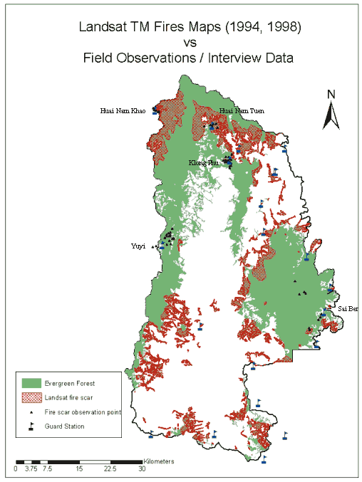
Field observations and interviews were conducted between February and April, 2001. Thirty-eight days were spent sampling. Several days were spent at each of five forest guard stations (Figure), which ranged in elevation from 500 to 1000 meters. The guard station was used as a base and excursions were made into the surrounding seasonal evergreen forests. Excursions were generally single day traverses, however multi-day trips were also undertaken. Forest conditions were monitored for species and canopy cover at 1 km intervals, with observations of burn marks on trees were made continuously. Guards were interviewed as to when each fire occurred, where and how it started, and where it spread.
Fire history (Landsat TM data) confirmed burning in seasonal evergreen forests. In most cases, fires only affected the edge of evergreen forests except in the northern part of the sanctuary where a fairly substantial area of seasonal evergreen forest was shown to have burned (Figure). Forests in these areas were considerably less `evergreen' than anticipated. Sampling near Huai Nam Khao and Huai Nam Tuen for example was often curtailed by the lack of seasonal evergreen forests. Mixed deciduous species and pockets of bamboo, a highly flammable species, were also frequently encountered. A large area of grassland abuts the forests to the north and west of Huai Nam Khao (Figure). Fires frequently burn through the grassland area and into the forest (Guard, pers., 2001).
The fieldwork and interviews revealed fires to have burned much more extensively through evergreen forests than indicated by the existing fire scar maps (Figure). Traverses across the evergreen zones of the sanctuary and interviews with Sanctuary guards indicated fires not shown on the maps, penetrated deep into `intact' seasonal evergreen forest. Guards recounted a major fire near Yuyi Guard Station in 1998. Signs of the fire were found on trees in moist, mature, closed canopy evergreen forests; for example, leeches, a fire sensitive species, were abundant. The Guard stated that the fire started in a small grassland area and moved through intact forest in a northwesterly direction. Some trees were candled. There was another major fire in the eastern block of seasonal evergreen forest near Sai Bur Guard Station in 1994 (Figure). Forests in this area are among the wettest in the sanctuary with more tropical rain forest elements such as palms present. The forests here appear too moist to burn, however burn marks are present on trees and pockets of successional banana indicating some previous disturbance. One Guard described how all the fires burning near the base of the mountain suddenly came together and moved up the mountain. Bunyavejchewin, a forest ecologist with the Royal Forest Department, observed burning through the 50 ha permanent plot near Klong Phu in 1990 (partially), 1992 and 1998 (pers. com, 2001). Forests in and around Klong Phu are primarily `intact' closed canopy evergreen forests which is the reason the permanent plot was established there in 1991 (Bunyavejchewin and Baker 1995). None of the fires reported by guards to have burned through `intact' seasonal evergreen forests is shown on the existing fire scar maps.
The most likely explanation for the difference between the relatively high resolution satellite sensor-derived fire scar maps, and ground observations and interviews is that the Landsat TM sensor was not able to detect low intensity surface fires beneath the evergreen forest canopy. In general, fires in deciduous forests are evident because the forest canopy is predominantly leafless in the fire season. This fact explains why fires were more apparent in the northern forest area of Huai Kha Khaeng. The forests near Huai Nam Khao and Huai Nam Tuen showed considerable disturbance and ecotone change towards a more mixed deciduous and even dry dipterocarp forest character. Some fires may also have been `missed' because some of the satellite images used to represent the fire season were obtained prior to the end of the fire season.
Satellite imagery is increasingly used to document areas of burn in Thailand and throughout southeast Asia. Often the sensors used have a much coarser resolution than the Landsat TM sensor such as 1 km AVHRR. Landsat TM is commonly used to validate other satellite sensor data in lieu of ground work.
There is no question but that extensive areas of `intact' seasonal evergreen forest have burned in recent years. Still, forest literature for the region suggests that `intact' evergreen forests do not burn. Recent satellite-sensor generated maps fail to show the extent of fire in closed canopy seasonal evergreen forests. The implications are that the remaining seasonal evergreen forests - those in protected areas - are burning much more extensively than we are currently aware. Ground truthing and the improved monitoring of fire in evergreen forests in the seasonal tropics are needed to determine the extent of the problem.
Batchelder, R. B. et al. 1966. Fire in Tropical Forests and Grasslands. Boston, Massachusetts, Boston University: 183.
Bunyavejchewin, S. and P. Baker 1995. Forest Fire and the Huai Kha Khaeng Wildlife Sanctuary. http://www.ctfs.si.edu/newsletters/inside1995/bunya1995.htm
Bunyavejchewin, S. et al. 1998. Topographic Analysis of a Large-scale Research Plot in Seasonal Dry Evergreen Forest at Huai Kha Khaeng Wildlife Sanctuary, Thailand. Tropics. Vol 2 (1/2): 45-60.
Elliott, S. and Ookaew B. 1992. The Importance of Doi Suthep - Pui National Park for Wildlife Conservation, Scientific Research and Education. Tiger Paper. Vol 19 (3): 1-6.
Elvidge, C. 2002. Pre-Workshop on NR-GOFC Fire Cal/Val. Global Observation of Forest Cover (GOFC). http://www.th.apan.net/abstract/jan23.ppt
Eyre, S. R. 1968. Vegetation and Soils. London, Edward Arnold Publishers Ltd.
Giri, C. and S. Shrestha 2000. Forest fire mapping in Huay Kha Khaeng Wildlife Sanctuary, Thailand. International Journal of Remote Sensing. Vol. 21 (10): 2023-2030
Goldammer, J.G. 1993. Historical Biogeography of Fire: Tropical and Subtropical. In: Fire in the Environment: The Ecological, Atmospheric, and Climatic Importance of Vegetation Fires. Eds. P.J. Crutzen and J.G. Goldammer. John Wiley & Sons Ltd. 297-314.
Kanjanavanit, S. 1992. Aspects of the Temporal Pattern of Dry Season Fires in the Dry Dipterocarp Forests of Thailand. Ph.D. Thesis. University of London, London, p.268.
KUFF 2000. Final Report: Reviewing Fire Management Policy in the Conservation of the Thung Yai and Huay Kha Kheng Wildlife Sanctuaries and World Heritage Areas of Thailand. Kasetsart University, Faculty of Forestry. Bangkok, Thailand
Nakhasathien, S. and B. Stewart-Cox. 1990. Nomination of the Thung Yai - Huai Kha Khaeng Wildlife Sanctuary to a UNESCO World Heritage Site. Wildlife Conservation Division, Royal Forest Department. Bangkok, Thailand.
Ofren, R.. 1999. Spatial Assessment and Hazard Modeling of Tropical Forest Fires. Ph.D. Thesis. University of Auckland, New Zealand.
Rabinowitz, A. 1990. Fire, Dry Dipterocarp Forest, and the Carnivore Community in Huai Khaeng wildlife Sanctuary, Thailand. Natural History Bulletin Siam Society. Vol. 38: 99-115.
Richards, P. W. (1952). The Tropical Rain Forest: an ecological study. London, Cambridge University Press.
Rundel, P. W. and K. Boonpragob (1995). Dry Forest Ecosystems of Thailand. In: Seasonally Dry Tropical Forests. S. H. Bullock, H. A. Mooney and E. Medina. Cambridge, Cambridge University Press: 93-123.
Stott, P. (1986). The Spatial Pattern of Dry Season Fires in the Savanna Forests of Thailand. Journal of Biogeography Vol. 13: 345-358.
Stott, P. (1988). The Forest as Phoenix: towards a biogeography of fire in mainland South East Asia. Geographical Journal. Vol. 154: 337-350
Stott, P. (1990). Stability and Stress in the Savanna Forests of Mainland South-East Asia. Journal of Biogeography. Vol 17: 373-383.
Stott, P. A., J. G. Goldammer and W. W. Werner (1990): The role of fire in the tropical lowland deciduous forests of Asia. In: Fire in the tropical biota. Ecosystem processes and global challenges (J.G. Goldammer, ed.), 32-44. Ecological Studies 84, Springer-Verlag, Berlin-Heidelberg-New York, 497 p.
Vibulsresth, S., S. Ratanasermpong and R. Suwanweerakamtorn. 1994 Forest Fires Monitoring and Assessment by Using TM Images. Proceedings of the 15th Asian Conference on Remote Sensing. Vol. 1. ACRS 1994, Nov 17-23. Bangalore, India.p. E-1-1 - 1-6.
Wharton, C. F. 1966. Man, Fire and Wild Cattle in north Cambodia. In: Man, Fire and Wild Cattle in southeast Asia. Wharton, Charles F. (ca. 1986). Monograph. Proc. 5th Ann. Tall Timbers Fire Ecology Conference: 23-65.
Whitmore, T. C. (1975). Tropical Rain Forests of the Far East. Oxford, Clarendon Press.
Bunyavejchewin, S. Royal Forest Department. Silviculture Division. March 2001.
Guard. Huai Kha Khaeng Wildlife Sanctuary. February 2001.
Ratanasermpong, Surachai. National Research Council of Thailand. May 2001.
1 PO Box 3050, Department of Geography, University of Victoria, Victoria, BC, Canada V8W-3P5. [email protected]