0505-B1
V.P. Mohan[1] and Vu Tan Phuong
Viet Nam, a country in transition that has been going through a process of economic renovation since 1986, is perhaps one of the countries most committed to ensuring that forestry supports poverty alleviation. In order to revamp the forestry sector and to counter the devastating deterioration of forests, in 1998 it launched an ambitious National Five Million Hectares Reforestation Programme (FMHRP) with three major objectives: (1) to restore forest cover to 43% by 2010; (2) to create employment opportunities, contribute to hunger elimination and poverty reduction (3) to provide forest products for industrialization, modernization and export.
With a view to assisting the Ministry of Agriculture and Rural Development in the effective implementation of the National FMHRP, the Food and Agriculture Organization of the United Nations is supporting a Technical Cooperation Project (TCP/VIE/0066) from March 2001 to March 2003. The Project seeks to create an enabling implementation framework by focusing on three interrelated outputs: (1) Generate a set of criteria and indicators (C&I) for forest land evaluation (FLE); (2) Develop guidelines for participatory forest land use planning; (3) Elaborate guidelines for monitoring and evaluating plantation establishment and natural forest regeneration.
As a case study, the paper elaborates the evolving methodology and emphasizes its potential for replication in other countries as well, for efficient planning and for orienting eventual implementation of reforestation to support rural livelihoods.
The Food and Agriculture Organization of the United Nations (FAO) had been a partner of Vietnam since 1978 in supporting agricultural development. Since the beginning of 1999, the multilateral and bilateral organizations that are most active in forestry have joined together with the Government in support of the National Five Million Hectares Reforestation Programme. This ambitious initiative launched to counter the devastating deterioration of forests aims to restore the forest cover of the country to 43% by 2010. FAO is an active partner in the Government -Donor Partnership, and is committed to its future success. More specifically, a Technical Cooperation Programme TCP/VIE/0066[2] has been designed to assist The Ministry of Agriculture and Rural Development for effectively implementing the National FMHRP. The Project of 24 months duration from March 2001 to March 2003 has a budget support of USD 333,230. The Forest Inventory and Planning Institute (FIPI) is responsible for its execution. The Project seeks to evolve an enabling implementation framework by focusing on the following three interrelated outputs:
I. Generate a set of Criteria and Indicators(C&I) for Forest Land Evaluation (FLE).
II. Develop Guidelines for Participatory Forest Land Use Planning. (PFLUP)
III. Elaborate Guidelines for Monitoring and Evaluating Plantation Establishment and Natural Forest Regeneration.
This paper reports on work carried out in Vietnam by highlighting conceptual issues and methodological learning of developing an enabling frame work of Criteria and Indicators for Forest Land Evaluation designed for improving eventual implementation of reforestation. The process of developing this methodology and testing was completed at all stages as a collaborative work based on consultancy inputs by V.P. Mohan, International Consultant, FAO and support of two national level institutions namely FIPI and Forest Science Institute of Vietnam (FSIV).
The key objective of evolving an enabling frame work of C & I for FLE is to improve the methodology for evaluating forest land in terms of its productive potential and suitability for specific purposes of natural regeneration and tree planting. It aims to provide simple guidelines to planners and implementing agencies to assess the potential productivity of a certain piece of land to determine whether or not it is suitable for intended silvicultural treatment/choice of given species.
The process of conceptualization, testing and finalization of the basic framework of Criteria & Indicators in its present stage has been completed from August 2001 to April 2002; having gone through stage wise refinements, broadly in three interlinked phases as follows:
?Conceptualization Phase
The initial stage of the process commenced with the first Mission of 60 days undertaken between August - October 2001 in completing the following activities:
Institutional contacts with National agencies and key International Projects,
Evaluation and analysis of available documentation,
Frequent internal discussions with FIPI, FSIV and other key related institutions for developing a shared vision,
Field visits to two sites namely Son Dong District, Bac Giang Province in North-East Region and An Khe District, Gia Lai Province in Central Highland Region; 13 consultative meetings at Province, District, Commune and village levels to assess existing practices and constraints,
Synthesis of all inputs for conceptualizing a basic framework to elaborate key issues,
Sharing in a Workshop in October 2001, the rationale and conceptual parametres necessary for developing a set of preliminary C & I,
Finalization of a preliminary set of C & I for FLE of bare lands, to be tested by FSIV and developing a Working Draft Report on the first Mission for comments and suggestions.
?Testing Phase
FSIV having been contracted for field testing and related activities has completed the process of preparatory field surveys and actual testing of the preliminary set of C & I from October 2001 to April 2002. Testing results at two sites had established the relevance of the preliminary C & I as a workable framework for assessing suitability of bare lands for forestry/agro forestry interventions. In addition many useful findings relating to field realities had emerged for fine-tuning its applicability for micro-level assessments in a practical manner
?Finalization Phase
In the finalization and validation phase, a second Mission of 30 days was undertaken during March - April 2002. The process of finalization of C & I integrates in a holistic manner the results of testing and necessary adjustments suggested during the following stages of validation and finalization.
Synthesis of results of testing by FSIV.
Adjustments of preliminary C & I.
Validation and consolidation process for documentation of final set of C & I including drafting of Guidelines for application of C & I in the field.
Consultations with FSIV/FIPI to incorporate minor adjustments.
An analysis of the current status of land use and key aspects of forestry sector formed the basis of developing this methodology in order to relate it more closely to ground realities.
Since 1986, Vietnam has embarked on an ambitious programme of reforms “Doi moi” as a process of transformation and an important part of a wider national process of change. The “Doi moi” philosophy encompasses the combination of policy and institutional adaptations associated with liberalization, opening up and reforms. Its adoption has resulted in rapid economic advances in all sectors particularly agriculture, forestry and fisheries. Recognizing the urgent need to promote development that balances environmental protection with economic progress for the benefit of the people, suitable strategies are being evolved.
According to the approved results of the overall inventory of land use in 2000 by Prime Ministerial Order No 24/2001/QD-TTg dated 1 March 2001, Vietnam has a total area of 32,924,061 ha (32.92 million ha)[3]. Three fourths of the terrain is hilly and mountainous, with a complex topography carved with many mountains, rivers, high plateaus and plains of different sizes. Hilly areas are relatively sparsely populated, with most of the 76 million2 people concentrated in intensively cultivated alluvial plains. The status of current land use is as follows:
Table 1. Existing land use statistics
Unit: Million hectares
|
Category |
Total Geog. Area |
Land Granted and for Rent |
||
|
Area |
% |
Area |
% |
|
|
Total area |
32.92 |
100.0 |
23.84 |
100 |
|
1. Forestry land covered by trees |
11.58 |
35.16 |
9.81 |
41.13 |
|
2. Agriculture land |
9.35 |
28.39 |
9.35 |
39.20 |
|
3. Unused land, springs, mountains |
10.02 |
30.46 |
2.71 |
11.38 |
|
4. Specially used land |
1.53 |
4.65 |
1.53 |
6.43 |
|
5. Homestead land |
0.44 |
1.34 |
0.44 |
1.86 |
Figure 1. Pie chart of existing land use statistics
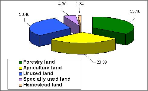
Source: Statistical Year Book 2000
Vietnam is experiencing a fundamental transition period whereby great demands are put on forests and other natural resources by the rapid economic growth. Sustainability in the management of forests and forestlands is a key environmental and social issue. The on-going policy reform, in particular the allocation of forestlands to farmers is providing new basis for future development strategies that have to be converted into actions. The Government of Vietnam is in the process of renovating its strategies for forestry development in order to bring these in line with new, broader socio-economic policies and orientation to a market economy.
· Forest Cover
The latest statistics[4] on forests according to the approved results of the overall inventory of forest in 1999 by Prime Ministerial Order No 03/2001/QD TTg dated 5 January 2001 are as under:
Table 2. Statistics of forest inventory results
|
Category |
Planned forest cover by 2010 |
Forested area |
Non forested land |
FMHRP targets |
||
|
Total |
Natural |
Planted |
||||
|
1. Protection forest |
6.0- 6.5 |
5.35 49% |
4.81 90% |
0.54 10% |
0.7- 1.2 |
1.0 |
|
2. Production forest |
8.0 |
4.04 37% |
3.17 78% |
0.87 22% |
4.0 |
3.0 |
|
3. Special- use forest |
2.0 -2.5 |
1.52 14% |
1.44 96% |
0.06 4% |
0.5- 1.0 |
1.0 |
|
Total |
16.0 - 17 |
10.91 |
9.44 87% |
1.47 13% |
5.2 -6.2 |
5.0 |
|
Percentage of geographical area |
50 |
33.14 |
28.67 |
4.46 |
15 |
15 |
Figure 2. Pie chart of forest areas of three categories
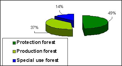
Source: Draft Forestry Development Strategy 2001-2010
The total forest area countrywide is 10.9 million ha. accounting for 33% of the total geographical area. The natural forests comprise 87% and plantations account for 13%. The above statistics indicate that forests are categorized into three functional categories:
In Vietnam, the entire thrust of reforestation activities is centered on the National FMHRP and consequently in relation to its objectives and key tasks, an effort has been made to develop the methodology of forest land evaluation and its intended application for improving planning and eventual implementation of reforestation activities. Conceptually the methodology would enable that agro forestry interventions effectively support rural livelihoods in a country having predominantly rural population which is considered as the driving force to re-create the forest asset.
?Objectives
In December 1997, the second session of the Tenth National Assembly of the Socialist Republic of Vietnam passed a Resolution on creation of five million hectares of new forest during the period from 1998 to 2010. The National Five Million Hectares Reforestation Programme (FMHRP) has been launched in accordance with a Prime Ministerial decision No 661 of July 1998. Subsequently a Joint Circular No 28/1999 of February 1999 elaborates targets, guiding principles and tasks of this programme. Another related Circular No 28/199 of March 1999 embodies detailed guidelines on management of State funds for FMHRP. The programme has three major objectives:
1. Establish five million hectares of new forest together with protection of existing forests in order to increase the forest cover to 43% of the national territory, protect the environment, decrease the severity of natural disasters, increase water availability, preserve gene resource and protect biodiversity.
2. Use open land and bare hills efficiently, create employment opportunities, contribute to hunger eradication and poverty reduction, support fixed cultivation and sedentarization, increase income for mountain rural people, create stable social conditions and strengthen national defence and security, especially in border areas.
3. Provide material for construction as well as raw material for production of paper, wood based panels, non-wood products and also fuel wood for local consumption as well as for export; develop the forest product processing industry, make forestry become an economic sector, and contribute to improvement in the socio-economic situation in mountain areas.
Conceptually the underlying approach followed in identifying most relevant bio-physical site characteristics and socio-economic parametres (Criteria) was mainly based on the existing site classification methods being followed in some Projects. To strengthen this analysis, an effort was made to make it consistent with concepts recommended under international practices. However standardized classification systems had to be adapted to match with country specific requirements.
?Definitions
· Forest Land
The definition of forestland as given in Decree 163/1999 of November 16, 1999 covering two types of lands is as follows:
Land which has natural or planted forest.
Land which does not have forest but should be afforested through planting, assisted natural regeneration, or protection of vegetation for forestry purposes.
· Non-forested Land (Bare Land)
According to Regulation No 84 on Forest Management and Planning issued by the former Ministry of Forestry, non-forested land (bare land) means that the vegetation on the land is not classified as forest.
Non-forested land consists of grass, shrubs or scattered woody trees with crown cover of less than 0.3 density. It is being followed by FIPI for preparing vegetation status maps and has three categories as follows:
I.a The vegetation cover typical for grass or banana plant.
I.b vegetation cover mainly bushes and some scattered timber trees or bamboo.
I.c The vegetation cover comprises regenerated woody trees. The number of regenerated woody trees is over 1000trees/ha and more than 1m high.
? Scope of Use
It should be clearly understood that the proposed Criteria and Indicators for Forest Land Evaluation have been developed basically for assessment of non-forested lands (bare lands) planned to be assessed for its suitability and potential for forestry/agro forestry interventions in:
Three categories of forests namely Production, Protection, and Special-use forests,
Home gardens, forest gardens, village forests, community forests, commune forests and mass organization forests.
The proposed frame work of C & I for FLE has two parts; the first part comprising 6 Biophysical Criteria and matching 23 Indicators(Verifiable quantitatively); and the second part comprising Socio-economic Criteria and Indicators(Qualitative information) It is necessary to explain that after completing field assessments for each land unit, the next step of consolidating and integrating results from all C & I has to be followed. Therefore, it is proposed to adopt a Positive Point Marking Method for consolidation of results by integrating assessments of indicators of 6 Biophysical Criteria. By this method each indicator is assigned a numerical point 4, 3, 2 and 1 as an index of its potential rating and suitability for FLE. For example point 4 assigned for Soil Type means that the individual rating of the indicator is the highest and in a descending order point 1 means that the rating is the lowest.(Table 3)
Weight age for Limiting Factors
Based on practical considerations, two Criteria namely Slope Class and Soil Depth, which strongly affect potential productivity, are given an over riding weight age as limiting factors while assessing overall grading of a site and adjusting it in three productivity classes as follows:
?Combination of Criteria and Grading of Indicators
For intended combination of C & I, the suggested system for assigning points for grading of indicators is as follows:
Table 3: Suggested system for assigning points for grading indicators
|
No |
Criteria |
Indicators |
Base point |
Adjusted point |
|
1 |
Soil type |
1.1. Loamy soil: Medium texture |
4 |
4 |
|
|
|
1.2. Clayey Soil: Heavy texture |
3 |
3 |
|
|
|
1.3. Sandy Soil: Light texture |
2 |
2 |
|
|
|
1.4. Eroded and stony soil |
1 |
1 |
|
2 |
Slope |
2.1. Slightly sloping: < 15° |
4 |
6 |
|
|
|
2.2. Moderately sloping: 16 - 25° |
3 |
3 |
|
|
|
2.3. Steep: 26 - 35° |
2 |
2 |
|
|
|
2.4. Very steep: > 35° |
1 |
0.5 |
|
3 |
Soil depth |
3.1. Deep: > 100 cm |
4 |
6 |
|
|
|
3.2. Moderately deep: 50 - 100 cm |
2 |
2 |
|
|
|
3.3. Shallow: < 50 cm |
1 |
0.5 |
|
4 |
Vegetation status |
4.1. Regrowth trees > 1000 trees/ha, H > 1m |
4 |
4 |
|
|
|
4.2. Regrowth trees 300-1000 trees/ha |
3 |
3 |
|
|
|
4.3. Regrowth trees < 300 trees/ha |
2 |
2 |
|
|
|
4.4. Mainly grass |
1 |
1 |
|
5 |
Altitude |
5.1. Low: < 300m |
4 |
4 |
|
|
|
5.2. Moderate: 300 - 700m |
3 |
3 |
|
|
|
5.3. High: 700 - 1700m |
2 |
2 |
|
|
|
5.4. Very high: > 1700m |
1 |
1 |
|
6 |
Rainfall |
6.1. High: > 2000 mm |
4 |
4 |
|
|
|
6.2. Moderate: 1500 - 2000 mm |
3 |
3 |
|
|
|
6.3. Low: 100 - 1500 mm |
2 |
2 |
|
|
|
6.4. Very low: < 1000 mm |
1 |
1 |
?Proposed Natural Potential Productivity Classes
Based on the above methodology, the potential productivity is proposed to be assessed and grouped into three classes as follows:
Table 4: Proposed natural potential productivity classes
|
Class of Potential Productivity. |
Total adjusted points of 6 Indicators as per Table 3 above. |
|
1. High- Land with few limiting factors for use. |
> 21 |
|
2. Medium- Land with some limiting factors for use. |
12-21 |
|
3. Low- Land with a number of limiting factors for use. |
< 12 |
By matching this classification with Socio-economic criteria, the next step of narrowing down priorities of forestry/agro forestry interventions according to location specific requirements is suggested.
In Vietnam a country wide classification of all regions, down to Commune level has been carried out into three categories reflecting the overall status of prevailing socio-economic factors by The Committee of Ethnic and Mountain Areas (CEMA). Three Regions are as follows:
I Primary Development Region.
II Relatively Stable Region.
III Difficult Region
The above classification is based on the following five criteria:
Based on results of assessment of natural potential productivity, and matching it with the classification of socio-economic conditions based on criteria and indicators of CEMA(Region I; Region II; Region III), present potential productivity can be assessed as follows:
Natural potential productivity of area of forest land in commune A is assessed high, but commune A is classified into Region III; therefore the present potential productivity of this area is considered medium.
Natural potential productivity of area of forest land in commune A is assessed low, but commune A is classified into Region I; therefore present potential productivity of this area is considered medium.
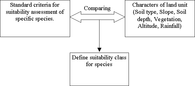
Finally for site and species matching, suitability of tree species is determined by comparing the actual results of field assessments based on biophysical C & I with standard criteria of suitability for each species. Suitability is classified into 4 categories:
(1) Highly suitable (S1)
(2) Moderately suitable(S2)
(3) Marginally suitable (S3)
(4) Not suitable or very limited(N)
Clearly each species requires certain environment for growing such as soil type, slope, climate conditions and altitude. Therefore based on research results of physio-ecological requirements of specific tree species it can be inferred that what condition is most suitable for planting.
After establishing standard criteria for suitability assessment for species, it will be followed by matching process as described below:
Figure 3: Suggested methodology of consolidating results
Innovative initiative: Conceptually the key objective of developing an enabling frame work of Criteria and Indicators for Forest Land Evaluation is to improve the methodology to be used for evaluating forest land for its potential and suitability for tree planting and natural regeneration.
Planning tool for implementation: In relation to degraded forest lands intended to be rehabilitated through reforestation, the application of C & I for FLE through analysis of the existing data and available maps supplemented with on- ground verification would certainly help implementing agencies to realistically assess potential productivity/suitability of the site and match suitable species for reforestation in a way that agro forestry interventions effectively support rural livelihoods.
Thus from a practical perspective, the suggested methodology could provide a strong technical basis for sustainability and economic efficiency of any major reforestation programme.
Scope for replication: The reforestation programmes in many developing countries are generally constrained by scarce financial resources coupled with poor site/species matching. Viewed in this context, the proposed methodology would facilitate efficient implementation through cost effective field activities of planting suitable species matching with potential productivity of the site and socio-economic factors.
Clearly the results of the above methodology backed by field testing suggest its scope and practicality for other countries as a model for replication with necessary adaptation for efficient planning and for orienting eventual implementation of reforestation to support rural livelihoods.
Agriconsulting S.p.a December 2000: Draft Final Report. Study on the Policy and Institutional Framework for Forest Resources Management (ADB 3255-VIE)
CIFOR 1999: The CIFOR Criteria and Indicators. Criteria and Indicators Toolbox Series.
FAO. 1983: Guidelines: Land Evaluation for Rain fed Agriculture. FAO Soils Bulletin 52. FAO Rome.
FAO. 1984: Land Evaluation for Forestry. FAO Forestry Paper 48. FAO Rome.
FAO. 1992: Land Evaluation for Forest Resource Development Planning at National Level. FAO Rome.
FAO 1998: Asia and the Pacific: National Forest Programmes: Update 33. FAO Bangkok.
FAO. 1999: Terminology for Integrated Resource Planning and Management. FAO, Rome.
FAO 1999: State of the World, s Forests, FAO Rome.
FAO 2001: A Compendium on Criteria and Indicators for Sustainable Forest Management. Working Paper FM/5.
FAO. 1999: Terminology for Integrated Resources Planning and Management.
FAO 2001: Country Profile for the Forum on “The Role of Forestry in Poverty Alleviation” Vietnam.
FSIV 2001: Assessment of Potential Productivity of Forestland in Vietnam.
Ministry of Agriculture and Rural Development 2001: National Five Million Hectare Reforestation Programme, Hanoi.
International Cooperation Department, Forest Sector Support Programme and Partnership, Part I Draft Memorandum Of Agreement. Hanoi.
Statistical yearbook 2000: Statistical Publishing House, Vietnam.
TCP/VIE/0066 Technical Support for the Five Million Hectares Reforestation Project, Project Implementation Plan 2001-2003.
To Dinh Mai 2001: Analysis of Policies of the 5MHRP.
| [1] Former Principal Chief
Conservator of Forests, Sunny Villa, Nigam Vihar, Shimla 171002-India. Tel/Fax:
0091-177-223753; Mobile: 0091-98160-23375; Email: [email protected];
[email protected] [2] Project Implementation Plan 2001-2003 - May 2001 Version [3] Statistical Year Book 2000 [4] Draft Forestry Development Strategy 2001-2010 |