0854-B3
Sarah Tewolde-Berhan 1,4, Ralph Mitlöhner 2, Bart Muys3 , and Mitiku Haile 4
Several interventions have been tried to tackle environmental degradation in Tigray, Northern Ethiopia. One of which is the establishment of closed areas. Establishing closed areas is a method, by which an area is protected from human and livestock interference. This study tries to analyse the improvement of the vegetation in the degraded sites of a Juniper-Olea afromontane forest. This was achieved by comparing the vegetation of different aged closed areas, of 25 years, 5 years, a grazing land, and an ancient forest that has not been disturbed for at least 500 years. To achieve the intended objective, samples of 0.16 ha were taken from the above four sites, where the number of trees, shrubs, grasses and herbs was counted, and their species was identified. In addition semi-structured interviews were undertaken and analysed to assess how the local people understand and feel about the intervention From the information collected the species composition, abundance, dominance and frequency of trees was computed; species similarity indices were calculated; and species area curves were drawn for trees, saplings and shrubs, seedlings, and herbs and grasses. It appears that the ancient forest is in a degraded state. Both closed areas and the grazing land have very different species compositions as compared to the forest. Moreover, all land use types show very few tree seedlings, indicating a future problem in the development of a forest. The closed areas were established with the full participation of the local community. Yet there are some gaps regarding the future management and utilization of the closed areas. It is clear that intensive forestry and silvicultural activities are needed in order to manage and improve the productivity of the closed areas in such a way, that the conservation of biodiversity, environmental sustainability, and the demands of the local people can be met.
The environmental degradation in the Northern part of Ethiopia, Tigray is a well-documented fact (TFAP 1996). To tackle this problem several interventions have been tried, one of which is the creation of closed areas. Closed areas are land units protected from human and livestock interference. Many degraded forests and woodlands have been set aside and closed for rehabilitation. In 1996 there was a plan to establish 128,000 ha of closed areas by 2001, and until then about 143,000 ha of closed areas were established (TFAP 1996). This methodology of environmental improvement appears to be successful (MUC 1996), but no substantive investigation to quantify the improvements has been attempted. This study tries to quantify the degree of rehabilitation of the vegetation in a degraded site, with a potential natural vegetation of Juniper-Olea afromontane forest (Friis 1992). This is done by comparing the vegetation in closed areas with ages, 25 and 5 years and a grazing land with an adjacent ancient forest and a grazing land.
Figure 1, Map showing the study site, and the Tigray region in Ethiopia
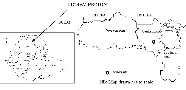
The study was undertaken in the highlands of Degu'a Tembien in Central Tigray, Northern Ethiopia (Figure 1). The bedrock of Degu'a Tembien is derived from volcanics of the Tertiary age, and consist of deeply weathered thick basalt flows (MUC 1996). The climate of Degu'a Tembien is classified as Dega - according to the traditional altitudinal climatic classification. This means that the area lies between 2,200 m.a.s.l. and 2800 m.a.s.l. The average annual rainfall at Hagere Selam, which lies in the centre of Degu'a Tembien, from 1973 to 1982 and 1992 to 1994, was 749 mm. The mean annual temperature during the same period was 15˚C. Hagere Selam lies 50 Kilometres southwest from Mekelle, the capital of Tigray region (MUC 1996).
To achieve the intended objective, a sample of 0.16 ha was studied in each of the above four sites. A cluster sampling method using 8 strips of 10 meter width, and 20 meter length was used. The strips were arraigned pointing out in north, northeast, east, southeast, south, southwest, west, northwest directions out of a central point. Sampling was done in 3 compartments namely A, B and C. Where A is 10 meters by 10 meter; B is 5 meter by 5 meter; and C is 1 meter by 1 meter. Each of these is arranged in a concentric manner, with the smaller compartments falling within the larger ones. In compartment A, the frequency, abundance and DBH of trees with a DBH greater than 10 cm were measured. In compartment B, the frequency and abundance of shrubs and saplings were recorded. In compartment C the frequency and abundance of seedlings, grasses and herbs were recorded. For all the plants sampled, the species were identified. Based on the collected data the species composition, abundance, dominance, frequency (Lamprecht 1990), and importance value index (IVI) (Curtis and McIntosh 1951 in Lamprecht 1990) of trees were calculated. The IVI is a sum of relative abundance, relative frequency and relative dominance. Subsequently, a species similarity index was calculated using the method of Weidelt (1968) that considers both presence, or absence, and abundance of species. The formula used to calculate the similarity index is as follows:
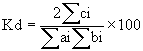
Where: Kd = similarity coefficient modified by Weidelt
Following, species area curves were drawn for trees, saplings and shrubs, seedlings, and herbs and grasses following Lamprecht (1990). Finally, semi-structured interviews were undertaken and analysed, and literature from other similar studies was looked at to assess how the local people understand and feel about the intervention.
Table 1 shows the species composition, abundance, dominance and frequency of trees found in the ancient forest is presented. Table 2 shows a species comparison using Weidlt's similarity index to compare the different land use types. Figures 2-5 are species area curves drawn for the trees, saplings and shrubs, seedlings, and herbs and grasses. These curves show the differences in species area distribution for the different land use types.
Table 1. Abundance, dominance, frequency and important value index for the trees in the Ancient Forest.
Species |
..........................Total............................. |
Average height |
Average basal area |
IVI |
Frequency Class | ||
Abundance N/ha |
Dominance sq.m/ha |
Frequency % | |||||
Acokanthera schimperi |
306.25 |
5.70 |
75 |
4.00 |
0.0186 |
93.99 |
IV |
Rhus natalensis |
106.25 |
4.65 |
68.75 |
5.14 |
0.0438 |
58.95 |
IV |
Rhus glutinosa |
56.25 |
3.58 |
31.25 |
4.46 |
0.0636 |
34.23 |
II |
Euphorbia abyssinica |
50 |
2.46 |
25 |
4.73 |
0.0492 |
26.34 |
II |
Maytenus arbutifolia |
87.5 |
1.22 |
25 |
3.62 |
0.0139 |
26.32 |
II |
Olea europeae subsp. cuspidata |
31.25 |
1.99 |
31.25 |
13.15 |
0.0637 |
23.86 |
II |
Ekebergia capensis |
25 |
2.42 |
12.5 |
18.35 |
0.0968 |
18.31 |
I |
Grewia ferruginea |
43.75 |
1.23 |
18.75 |
14.63 |
0.0281 |
17.99 |
I |
Total |
706.25 |
23.24 |
287.5 |
||||
The dominant species in the ancient forest are the understory trees which include Acokanthera schimperi, Rhus natalensis, and Rhus glutinosa (table 1). The ancient forest is found in a degraded status, as the dominant species are understory species with small heights and lower basal area per tree. Moreover, the few number of species, only 8, indicates the degradation level of the forest. From a total of 4.5 ha area, the land covered with trees is not greater than 2 ha, the rest being a highly disturbed forest. The disturbance of the forest had occurred as cattle were taken into the forest to drink from a spring. For this reason the water has now been diverted outside the forest, and made accessible to cattle. The surrounding has very few trees to provide pollen and seeds for regeneration. The fragmentation, and lack of other isolated trees in the surrounding might as well have contributed to the species depletion of the forest.
Table 2. Species Similarity Index
Land use types compared |
Weidelt (1968) 's index |
Ancient Forest vs. old closed area |
33.82 |
Ancient Forest vs. young closed area |
16.65 |
Ancient Forest vs. Grazing land |
1.97 |
Old closed area vs. young closed area |
60.65 |
Old closed area vs. Grazing land |
77.63 |
Young closed area vs. Grazing land |
79.08 |
As can be seen in table 2, the species composition in the forest is very different from all the other land use types. However, the oldest closed area is the closest to the forest in its species composition with 33.82 % of the species in common between the two vegetation types. This indicates that even though the distances among all the sites are not that wide; the major regeneration source (tree seeds or vegetative material) for the other land use types might not be the forest. The old closed area, the young closed area, and the grazing land show very high similarities in species composition among themselves. This might indicate that these land use types are covered by pioneer species or by paraclimax species typical for grazing land.
The species area curves for trees, saplings and shrubs, seedlings, and grasses and herbs for the different land use types are shown in the following figures.
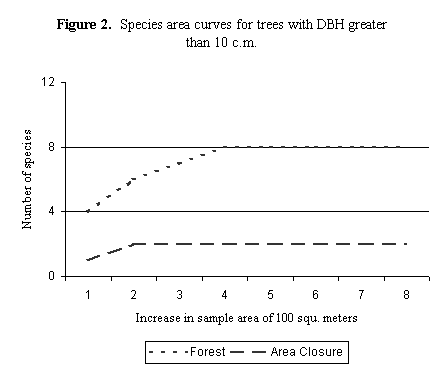
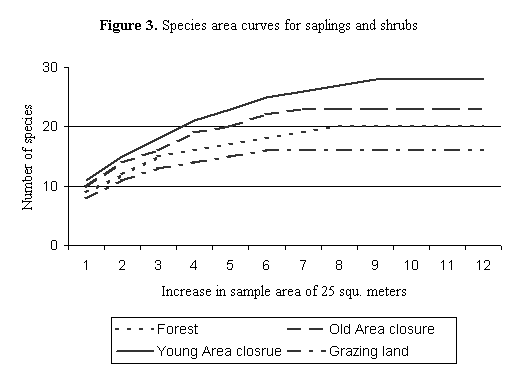
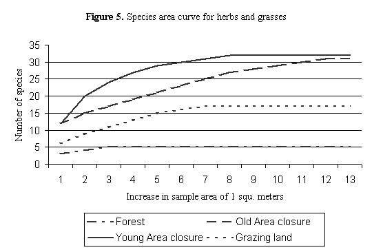
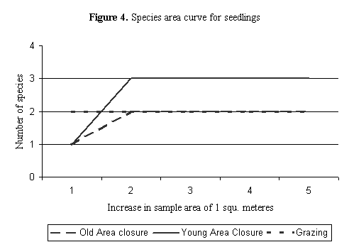
According to the species area curves, only the forest and the oldest closed area have trees with a diameter above 10 cm. Nevertheless, the two tree species in the old closed area have only one individual per species. 25 years is a long time to wait just to obtain two trees that could serve as a wood resource for a whole village community. As compared to the trees the sapling, shrub, grass and herb populations are doing better. What is astonishing rather, is the lack of seedlings in the forest, and the very few seedlings found in the other land use forms. Although further studies will be needed to verify this, the present circumstances in the forest and in the closed areas in terms of number of seed sources or success of germination and recruitment seem to be insufficient to produce enough seedlings for future forest regeneration.
According to the interviews conducetd, local communities in Tigray views closed areas more effective, and less demanding on resources than plantations. This is in agreement with previous studies (Aster 1998; MUC 1996). This is understandable as it would be easier for native pioneer grasses, herbs, shrubs, and trees to establish in the highly degraded lands as compared to nursery produced non-pioneer species. In addition to the small success of the planted trees, the additional labour cost of building soil and water conservations structures and planting of the seedlings makes closure areas more attractive. In the interviews carried out in the study site, and as indicated elsewhere (Aster 1998; Wisbourg et al 2000) the closed area intervention is carried out with the full participation of the local communities. The local community chooses which piece of land they want to close, and set up management rules and regulations regarding the utilization of the land. The local community is already benefiting form grass harvests, bee-fodder, and the improved environmental stability.
However, the local community is not clear as to what will happen with the land, and its management once it becomes more productive. The Bureau of Agriculture and the local administration (at levels higher than the village level) state that the closed areas belong to the local communities, and their fate needs to be decided by the local community. The bureau of Agriculture sees itself as an advisor, with the responsibility to guide the local community, and the administration sees itself as a means via which the advice is transmitted. So far the major focus is on the protection of the closed areas, and that is what the advice has focused on. The lack of plans for the future of the closed areas, and the lack of re-assurance that the management and utilization of these lands will fully be left to the local community result in insecurity. It is therefore mandatory that the Bureau of Agriculture, and the local administration focus on future plans, and re-assure the local community that the land utilization is fully theirs and that land re-distribution will not be carried out by the government. Such assurance is especially important, as the recent history in Ethiopia has seen so many land use changes.
The vegetation in the closed area is a long way from developing into a type of forest comparable to an ancient forest. 25 years is not a long time in terms of forest development and ecological succession, however it is a long time for land to be left for nature to heal itself. The significance of the cost of enclosing these areas can only be determined by looking at the opportunity values of the land. The ecological changes in increased species diversity have added to the value of the land. It is however clear that interventions are needed to improve the number of species, and seedlings of the species. In addition silvicultural management to improve the quality and status of the trees are needed. The closed areas were established with the full participation of the local community. Yet there are some gaps regarding the future management and utilization of the closed areas. These gaps need to be filled soon so that the local community will feel more secure and be ready to invest in the closed area. In this regard, silvicultural interventions should be oriented towards managing and improving the productivity of the closed areas, in such a way that the needs for conservation of biodiversity and environmental sustainability, and the demands of the local people for biomass resources and secondary `forest' products like honey can be met.
Firstly we would like to thank the German people and the government for establishing such a system making it possible for people like the first author to study in Germany. Special thank goes to the German Academic Exchanges Services (DAAD) and George August University of Göttingen for offering the scholarship and guidance to do the study. Thanks also goes to Mekelle University (Ethiopia) and K.U. Leuven (Belgium) who had provided logistic support during fieldwork in northern Ethiopia through a VLIR funded project on Forest Rehabilitation through Natural Regeneration in Tigray (Ethiopia).
Aster G., 1998. Local people's participation in reforestation; case study in Degua Tembien, Tigray, Northern Ethiopia. MSc thesis, Wageningen Agricultural University, Department of Forestry, Netherlands. 101 pp.
Friis, I., 1992. Forests and forest trees of northeast tropical Africa: their natural habitats and distribution patterns in Ethiopia, Djibouti and Somalia. Royal Botanic Gardens, Kew. London. 396 pp.
Lamprecht H., 1990. Silviculture in the Tropics. GTZ, Eschborn, Germany. 295 pp.
Million B., 2001. Country Report - Ethiopia; Forestry Outlook Studies in Africa. FOSA Working Paper. 39 pp.
MUC, 1996. Base-line Survey, to Assess Opportunities and Constraints for Future Reforestation Activities in Tembien, Tigray. Green Promotion Project in Tembien, Tigray. Mekelle University College (MUC), Mekelle, Ethiopia, 175 pp.
TFAP, 1996. Tigray Forestry Action Plan (TFAP). Tigray Bureau of Agriculture and Natural Resources Development, Regional Government of Tigray. Mekelle, Ethiopia. 122 pp.
Weidelt, H.-J., 1968. Der Brandhackbau in Brasilien und seine Auswirkungen auf die Waldvegetation. Diss. Forstwissenschaftlicher Fachbereich, Universität Göttingen, Germany. 163 pp.
Wisbourg, P., Shylendra, H., Kindeya, G., Shankar, R. Tilahun, Y. Ngothu, U. Sekhar, Tewolde-Berhan S. and Busi, P., 2000. Rehabilitation of CPRs through re-crafting of village institutions comparative study from Ethiopia and India. Paper presented at the 8th biennial conference of the International Association for Study of Common Property, IASCP, Bloomington, Indiana, USA; 31 May - 4 June, 2000. (http://dlc.dlib.indiana.edu/documents/dir0/00/00/03/81/dlc-00000381-00/wisborgp041400.pdf) 32 pp.
WRI, 2001. World Resource Institute. 2000/2001. Population and human development. A guide to the global environment. Oxford University Press, New York. 75-92 pp.
1 Corresponding Author: Georg-August Universität Göttingen, Institute of Tropical Silviculture, Büsgenweg 1, D-37077 Göttingen, Germany; e-mail: [email protected]
2 Georg-August Universität Göttingen, Institute of Tropical Silviculture, Büsgenweg 1, D-37077 Göttingen, Germany; e-mail: [email protected]
3 Laboratory of Forest, Nature and Landscape Research, K U Leuven Vital Decosterstraat 102, B-3000 Leuven, Belgium; e-mail: [email protected]
4 Mekelle University, Department of Land Resources Management and Environmental Protection, P.O. Box 231, Mekelle, Ethiopia; e-mail: [email protected]