0903-B2
M.L. Wilkie 1, S. Fortuna 2 and O. Souksavat 3
High population pressure in coastal areas has led to the conversion of many mangrove areas to other uses and numerous case studies describe mangrove losses over time. However, scarce information exists on status and trends in mangrove areas at the global level.
A recent initiative by the Food and Agriculture Organization of the United Nations (FAO) aims at facilitating access to comprehensive information on the current and past extent of mangroves in all countries and areas in which they exist. This builds on an earlier assessment by FAO/UNEP in 1980, the recent FAO Global Forest Resources Assessment 2000 (FRA 2000) and an extensive literature search.
More than 2800 national and sub-national data sets have been collected, covering 121 countries and areas, with the earliest estimates dating back to 1918. An updated list of the most reliable, recent estimate for each country has been compiled. Regression analyses of earlier data yielded estimates for 1990 and 1980 and an extrapolated estimate for 2000 for each country.
The analysis illustrated problems in generating reliable trends due to differences in methodology used over time as well as the lack of recent, reliable and comprehensive information - particularly for the extrapolation to Year 2000. This estimate is thus indicative only and is likely to change when results from on-going and future assessments become available.
The results suggest that the current mangrove area worldwide has now fallen below 15 million ha, down from 19.8 million ha in 1980, and that mangrove deforestation continues, albeit on a slightly lower rate in the 1990s (1.0 percent per annum) than in the 1980s (1.7 percent per annum) reflecting an increased awareness of the functions and values of mangroves. Most countries have now banned conversion of mangroves to other uses or require an environmental impact assessment prior to approval.
Mangroves are commonly found along sheltered coastlines in the tropics and sub-tropics where they fulfill important functions in terms of providing a large variety of wood and non-wood forest products and a number of environmental services such as coastal protection (against the effects of wind, waves and water currents); conservation of biological diversity - including a number of endangered mammals, reptiles, amphibians and birds; protection of coral reefs, seagrass beds and shipping lanes against siltation; and provision of habitat, spawning grounds and nutrients for a variety of fish and shellfish, including many commercial species.
High population pressure in coastal areas has, however, led to the conversion of many mangrove areas to other uses, including infrastructure, aquaculture, rice and salt production. Numerous case studies describe mangrove losses over time, but information on the status and trends of mangrove areas at the global level is scarce.
The first attempt at estimating the total mangrove area in the world was undertaken as part of the FAO/UNEP Tropical Forest Resources Assessment in 1980, where the world total was estimated as 15.6 million hectares. More recent estimates range from 12 to 20 million ha (refer to Table 1 below). For many of these studies, countries with small areas of mangroves were excluded due to lack of information and because their combined area of mangroves would not significantly affect the world total.
Table 1 Previous estimates of global extent of mangroves
Reference |
Reference Year4 |
Number of countries included |
Estimated World Total (ha) |
FAO-UNEP, 1981a,b,c |
1980 |
51 |
15 642 673 |
Saenger et al., 1983 |
1983 |
65 |
16 221 000 |
FAO, 1994 |
1980-1985 |
56 |
16 500 000 |
Groombridge, 1992 |
1992 |
87 |
19 847 861 |
ITTO/ISME5, 1993 |
1993 |
54 |
12 429 115 |
Fisher and Spalding, 1993 |
1993 |
91 |
19 881 800 |
Spalding et al., 1997 |
1997 |
112 |
18 100 077 |
Aizpuru et al., 2000 |
2000 |
1126 |
17 075 600 |
The objective of this paper is to present new and comprehensive information on the current and past extent of mangroves in all countries and areas in which they exist. This information was compiled as part of a recent FAO initiative aimed at facilitating access to such information by policy-makers, planners and managers worldwide. The paper also describes the results of a preliminary trend analysis and provides an estimate of the global mangrove area as of Year 2000. The study was not designed to provide information on the rate of mangrove degradation i.e. on changes in the health and quality of existing mangrove areas.
This study builds on the earlier FAO/UNEP assessment and on the recent FAO Global Forest Resources Assessment 2000 (FRA 2000), where all countries were asked to provide information on current forest area according to forest types, using their own classification system. Since mangroves form a distinct and relatively easy forest type to define, most countries, which have mangroves provided specific information on their extent.
An extensive literature search and requests for information sent to mangrove networks and individual specialists worldwide yielded additional information. More than 2800 national and sub-national datasets have been collected so far, covering 121 countries and areas where mangroves are known to exist, with the earliest estimates dating back to 1918 and the 1920s. The information has been analysed with the assistance of mangrove experts throughout the world. One of the results is an updated list of the most reliable, recent estimate for each country, mostly based on inventories or analysis of remote sensing imagery.
An initial screening of results included weeding out duplicates, discarding rough "guesstimates" and selecting just one estimate for those years where more than one was available. This was followed by regression analyses (best fit of linear, polynomial, logarithmic and exponential curves) of existing reliable data over time, which provided estimates for 1990 and 1980 and an extrapolated estimate for 2000 for each country. Where insufficient information was available, i.e. only one estimate within the last 30 years (less than 1 percent of the total mangrove area), the area was assumed to have remained constant unless qualitative information indicated otherwise.
Where recent information was unavailable (about 5 percent of the total mangrove area), the extrapolation to Year 2000 was based on the overall forest change rate as reported in the Global Forest Resources Assessment 2000 (FAO 2001) applied to the latest reliable estimate.
For details on reference sources and the methodology used for individual countries refer to FAO, in press a,b or to www.fao.org/forestry/mangroves. All primary datasets are accessible at the above website.
The regional and world totals are shown in Table 2 below. The year given for the regional total of the most recent, reliable estimate is the area-weighted average. The most reliable, recent estimates by country are shown in Table 3. Country level estimates for 1980, 1990 and 2000 can be found in FAO, in press b or at www.fao.org/forestry/mangroves.
Three examples of the trend analysis generated from the data are illustrated in Figures 1, 2 and 3.
Table 2: Status and trends in mangrove area extent by region.
Region |
Most reliable, recent estimate |
1980 |
1990 |
Annual change 1980-1990 |
2000 |
Annual change 1990-2000 | |||||||
000 ha |
Ref Year |
000 ha |
000 ha |
000 ha |
% |
000 ha |
000 ha |
% | |||||
Africa |
3 390 |
1993 |
3 659 |
3 470 |
-19 |
-0.5 |
3 351 |
-12 |
-0.3 | ||||
Asia |
6 662 |
1991 |
7 857 |
6 689 |
-117 |
-1.5 |
5 833 |
-86 |
-1.3 | ||||
Oceania |
1 578 |
1995 |
1 850 |
1 704 |
-15 |
-0.8 |
1 527 |
-18 |
-1.0 | ||||
N & C America |
2 103 |
1994 |
2 641 |
2 296 |
-35 |
-1.3 |
1 968 |
-33 |
-1.4 | ||||
South America |
2 030 |
1992 |
3 802 |
2 202 |
-160 |
-4.2 |
1 974 |
-23 |
-1.0 | ||||
World Total |
15 763 |
1992 |
19 809 |
16 361 |
-345 |
-1.7 |
14 653 |
-171 |
-1.0 | ||||
As with all analyses, the results depend on the quality of the inputs. In this particular case, changes in definitions and methodologies between assessments and surveys make it difficult to compare results over time. For some countries, the most recent estimate is a composite of sub-national figures due to lack of recent national figures and for others, the borders have changed or additional mangrove areas have been discovered recently, making such analyses very challenging.
The combined mangrove area of four countries (Indonesia, Brazil, Nigeria and Australia) has a strong influence on the global total, as these countries together account for an estimated 5 892 000 ha or 40 percent of the total mangrove area in the world.
Estimating the area of mangroves in Indonesia proved particularly difficult due to the lack of recent comprehensive information covering the whole country. Sub-regional estimates for eight main groupings of islands (Bali, Irian Jaya, Java, Kalimantan, Maluku, Nusa Tenggara, Sulawesi and Sumatra) were thus used to generate trends for Indonesia. However, estimates over time vary tremendously and no recent estimate exists for Irian Jaya. The area-weighted average year for the latest available estimate is thus 1988. For Brazil, Nigeria and Australia, the most recent figures date from 1991, 1995 and 1997 respectively.
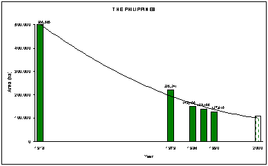
Figure 1. Mangrove area changes over time in The Philippines
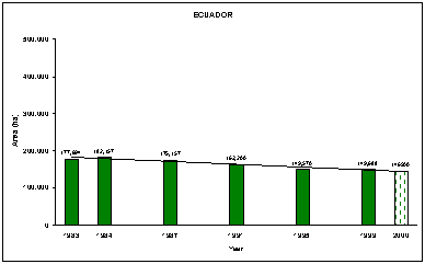
Figure 2. Mangrove area changes over time in Ecuador
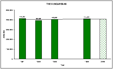
Figure 3. Mangrove area changes over time in The Sundarbans Reserved Forest, Bangladesh
Keeping the above caveats in mind, the results indicate that previous estimates of the total mangrove area made in the early 1980s were too low (mainly due to the limited number of countries included), whereas those made in the 1990s were too high. While the new estimates provided by this study for 1980 and 1990 and the most recent reliable estimate for 1992 (area weighted average year) are presumed to be the best available and fairly reliable in that they are primarily based on information from inventories and aerial surveys, the extrapolation to Year 2000 is, by nature, less reliable - particularly where few or no recent assessment results were available. This estimate is thus only indicative and likely to change as and when results from on-going and future assessments become available.
Nevertheless, the results indicate that the current mangrove area worldwide has now fallen below 15 million ha - down from 19.8 million ha in 1980 - and that mangrove deforestation continues, albeit on a slightly lower rate in the 1990s (around 170 000 ha, or 1.0 percent, per annum) than in the 1980s (around 345 000 ha, or 1.7 percent, per annum).
In absolute terms, the highest rates of mangrove deforestation in the 1980s were found in Brazil, Indonesia, Pakistan, Australia and Mexico. The same countries (except for Pakistan which has been replaced by Papua New Guinea) top the list of countries with the largest losses of mangroves in the 1990s, although the rates have diminished substantially in most of these. In relative terms, countries with high deforestation rates include Singapore, Benin, Dominica, Brazil and Côte d'Ivoire in the 1980s and Benin, Honduras, China, Congo and Barbados in the 1990s.
Conversely, a number of countries have registered a positive change over time, including Bangladesh, where the largest mangrove area (The Sundarbans Reserved Forest) is well protected and substantive and successful efforts have been made in coastal afforestation, particularly on land formed by accretion. Kuwait also registers a positive trend as mangroves have been planted as an introduced species. For other countries, an apparent positive trend may be due to changes in methodology or definition - or due to the discovery of new mangroves areas not previously included (e.g. United Arab Emirates).
The relatively large mangrove deforestation rates in Asia, the Caribbean and Latin America in the 1980s reflect large scale conversion of mangroves for aquaculture and tourism infrastructure. Most countries have now banned the conversion of mangroves for aquaculture purposes and require environmental impact assessments prior to large-scale conversion of mangroves areas for other uses.
Increased population pressures in coastal areas and lack of awareness of the many valuable functions provided by mangroves have lead to large scale conversion to other uses. Numerous case studies and anecdotal evidence exist describing mangrove losses over time. However, access to comprehensive information on the status and trends of mangrove areas at the global level has been limited.
The initiative by the FAO described in this paper aims at facilitating access to comprehensive information on the current and past extent of mangroves in all countries and areas in which they exist.
A preliminary analysis of available information indicates that the current mangrove area worldwide has now fallen below 15 million ha and that mangrove deforestation continues, albeit on a slightly lower rate in the 1990s than in the 1980s. The analysis also illustrated problems in generating reliable trends due to differences in methodology used over time as well as the lack of recent, reliable and comprehensive information.
In addition to providing access to all primary data and thus facilitating the analysis of these by others, the database also gives an indication of where information is lacking and efforts should be made to obtain more recent and reliable area estimates. Readers are strongly encouraged to provide additional information to help update and improve this data base for the benefit of all those who may have an interest in mangroves.
The authors gratefully acknowledge the very valuable information and insights provided by numerous mangrove and inventory experts worldwide. A list of people contacted is found in FAO (in press b).
Aizpuru, M, Achard, F. and Blasco, F., 2000. Global assessment of cover change of the mangrove forests using satellite imagery at medium to high resolution. In EEC research project n° 15017-1999-05 FIED ISP FR, Joint Research Center, Ispra.
Clough, B.F., 1993 The Economic and environmental values of mangrove forests and their present state of conservation in the South-East Asia/Pacific Region. Mangrove Ecosystems Technical Reports vol.1. ITTO/ISME/JIAM Project PD71/89 Rev.1 (F).
Diop, E.S.. 1993 Conservation and sustainable utilization of mangrove forests in Latin America and Africa regions, Part II - Africa. Mangrove Ecosystems Technical Reports vol.3 ITTO/ISME Project PD114/90.
FAO, in press a. FAO's database on mangrove area estimates. By Wilkie, M.L., Fortuna, S. and Souksavat, O. Forest Resources Assessment Working Paper No. 62. Forest Resources Division. FAO, Rome. (Unpublished)
FAO, in press b. Status and trends in mangrove area extent worldwide. By Wilkie, M.L. and Fortuna, S. Forest Resources Assessment Working Paper No. 63. Forest Resources Division. FAO, Rome. (Unpublished)
FAO, 1994. Mangrove forest management guidelines. FAO Forestry Paper 117, Rome. 319 pp.
FAO/UNEP, 1981a Los Recursos Forestales de la America Tropical Proyecto de Evaluación de los Recursos Forestales Tropicales, Rome, 343 pp
FAO/UNEP, 1981b Tropical Forest Resources Assessment Project, Forest Resources of Tropical Africa. Part II: Country Briefs. Rome, 586 p
FAO/UNEP 1981c Tropical Forest Resources Assessment Project, Forest Resources of Tropical Asia Rome, 475 pp
Fisher, P. and Spalding, M.D., 1993. Protected Areas with Mangrove Habitat. Draft Report. World Conservation Monitoring Centre, Cambridge, UK. 60 pp.
Groombridge, B., 1992 Global biodiversity: status of the earth's living resources. WCMC/The National History Museum/IUCN/UNEP/WWF/WRI. Chapman & Hall, London. 594 pp
Saenger, P., Hegerl, E.J. and Davie, J.D.S (Eds), 1983. Global Status of Mangrove Ecosystems. Commission on Ecology Papers No. 3. International Union for Conservation of Nature and Natural Resources (IUCN), Gland, Switzerland. 88 pp.
Lacerda L.D., 1993 Conservation and sustainable utilization of mangrove forests in Latin America and Africa regions, Part I - Latin America. Mangrove Ecosystems Technical Reports vol.2 ITTO/ISME Project PD114/90.
Spalding, M.D., Blasco, F. and Field, C.D. (Eds), 1997. World Mangrove Atlas. The International Society for Mangrove Ecosystems, Okinawa, Japan. 178 pp.
Table 3 Most reliable, recent mangrove area estimates by country
AFRICA |
ASIA |
OCEANIA |
||||||||
Country/Area |
ha |
Reference Year |
Country/Area |
ha |
Reference Year |
Country/Area |
ha |
Reference Year | ||
Angola |
60 700 |
1992 |
Bahrain |
100 |
1992 |
American Samoa |
52 |
1976 | ||
Benin |
1 700 |
1989 |
Bangladesh |
622 482 |
1992 |
Australia |
955 277 |
1997 | ||
Cameroon |
227 500 |
2000 |
Brunei Darussalam |
17 100 |
1992 |
Fiji |
42 464 |
1991 | ||
Comoros |
2 600 |
1976 |
Cambodia |
72 835 |
1997 |
Guam |
70 |
1993 | ||
Congo |
12 000 |
1995 |
China |
36 882 |
1994 |
Kiribati |
258 |
1995 | ||
Côte d'Ivoire |
15 000 |
1995 |
East Timor |
3 035 |
2000 |
Marshall Islands |
n.a. |
n.a. | ||
Dem. Rep. of Congo |
22 600 |
1995 |
India |
487 100 |
1997 |
Micronesia |
8 564 |
1983 | ||
Djibouti |
1 000 |
1985 |
Indonesia |
3 493 110 |
1988 |
Nauru |
1 |
1993 | ||
Egypt |
482 |
1998 |
Islam. Rep. Of Iran |
20 700 |
1994 |
New Caledonia |
20 250 |
1987 | ||
Equatorial Guinea |
25 700 |
1995 |
Japan |
400 |
1980 |
New Zealand |
22 200 |
1996 | ||
Eritrea |
6 400 |
1997 |
Kuwait |
2 |
2000 |
Niue |
3 000 |
1981 | ||
Gabon |
115 000 |
2000 |
Malaysia |
587 269 |
1995 |
Northern Mariana Islands |
7 |
1984 | ||
Gambia |
59 600 |
1993 |
Maldives |
n.a. |
n.a. |
Palau |
4 708 |
1985 | ||
Ghana |
10 000 |
1995 |
Myanmar |
452 492 |
1996 |
Papua New Guinea |
464 000 |
1993 | ||
Guinea |
296 300 |
1995 |
Oman |
2 000 |
1992 |
Samoa |
752 |
1993 | ||
Guinea-Bissau |
248 400 |
1990 |
Pakistan |
207 000 |
1990 |
Solomon Islands |
52 500 |
1995 | ||
Kenya |
52 980 |
1995 |
Philippines |
127 610 |
1990 |
Tokelau |
n.a. |
n.a. | ||
Liberia |
19 000 |
1995 |
Qatar |
500 |
1992 |
Tonga |
1 305 |
1990 | ||
Madagascar |
325 560 |
1987 |
Saudi Arabia |
20 400 |
1985 |
Tuvalu |
40 |
1993 | ||
Mauritania |
104 |
1993 |
Singapore |
500 |
1990 |
Vanuatu |
2 519 |
1993 | ||
Mauritius |
7 |
1991 |
Sri Lanka |
8 688 |
1992 |
Wallis and Futuna Islands |
n.a. |
n.a. | ||
Mayotte |
668 |
1989 |
Thailand |
244 085 |
2000 |
|||||
Mozambique |
392 749 |
1997 |
United Arab Emirates |
4 000 |
1999 |
Total Oceania |
1 577 967 |
1995 | ||
Nigeria |
997 700 |
1995 |
Viet Nam |
252 500 |
1983 |
|||||
Sao Tomé and Principe |
n.a. |
n.a. |
Yemen |
927 |
1993 |
|||||
Senegal |
182 400 |
1985 |
||||||||
Seychelles |
2 000 |
1995 |
Total Asia |
6 661 717 |
1991 |
|||||
Sierra Leone |
156 500 |
1986 |
||||||||
Somalia |
10 000 |
1975 |
||||||||
South Africa |
673 |
1991 |
||||||||
Sudan |
500 |
1995 |
||||||||
United Rep. of Tanzania |
143 284 |
1987 |
||||||||
Togo |
1 000 |
1999 |
||||||||
Total Africa |
3 390 107 |
1993 |
||||||||
NORTH AND CENTRAL AMERICA |
SOUTH AMERICA |
|||||
Country/Area |
ha |
Reference Year |
Country/Area |
ha |
Reference Year | |
Anguilla |
90 |
1991 |
Brazil |
1 012 376 |
1991 | |
Antigua and Barbuda |
1 175 |
1991 |
Colombia |
379 954 |
1996 | |
Aruba |
420 |
1986 |
Ecuador |
149 688 |
1999 | |
Bahamas |
141 957 |
1991 |
French Guiana |
55 000 |
1980 | |
Barbados |
14 |
1991 |
Guyana |
80 400 |
1994 | |
Belize |
65 767 |
1995 |
Peru |
4 791 |
1992 | |
Bermuda |
16 |
1992 |
Suriname |
98 121 |
1998 | |
British Virgin Islands |
587 |
2001 |
Venezuela |
250 000 |
1986 | |
Cayman Islands |
7 268 |
1991 |
||||
Costa Rica |
41 330 |
1992 |
Total South America |
2 030 330 |
1992 | |
Cuba |
529 700 |
1992 |
||||
Dominica |
10 |
1991 |
||||
Dominican Republic |
21 215 |
1998 |
||||
El Salvador |
26 800 |
1994 |
||||
Grenada |
255 |
1992 |
||||
Guadeloupe |
2 325 |
1997 |
||||
Guatemala |
17 727 |
1998 |
||||
Haiti |
15 000 |
1990 |
||||
Honduras |
54 300 |
1995 |
||||
Jamaica |
9 731 |
1997 |
||||
Martinique |
1 840 |
1998 |
||||
Mexico |
488 000 |
1994 |
||||
Montserrat |
5 |
1991 |
||||
Netherlands Antilles |
1 138 |
1980 |
||||
Nicaragua |
282 000 |
1992 |
||||
Panama |
158 100 |
2000 |
||||
Puerto Rico |
6 410 |
2001 |
||||
Saint Kitts and Nevis |
79 |
1991 |
||||
Saint Lucia |
200 |
2002 |
||||
Saint Vincent and Grenadines |
51 |
1991 |
||||
Trinidad and Tobago |
7 150 |
1991 |
||||
Turks and Caicos Islands |
23 600 |
1991 |
||||
United States |
197 648 |
2001 |
||||
United States Virgin Islands |
978 |
1991 |
||||
Total North and Central America |
2 102 886 |
1994 |
||||
1 Forestry Officer (Forest Management), Food and Agriculture Organization of the United Nations (FAO), Rome, Italy. Email: [email protected]
2 FAO Consultant. Email: [email protected]
3 FAO Consultant. Email: [email protected]
4 Except for FAO, 1981 and Aizpuru et al., 2000, the reference year is the year of the publications on which the estimate is based, not the weighted average of all the area estimates.
5 Combined figure from 3 publications by Clough, 1993; Diop, 1993 and Lacerda 1993
6 New data was provided for 21 countries, for the remaining countries the estimate is based on Spalding et al., 1997