
Food
and
Agriculture
Organization
of
the
United
Nations

by
Carlo Travaglia
FAO
Ljudmila
Milenova
Roumen Nedkov
Vassil Vassilev
Pavel Milenov
Radko
Radkov
Zlatka Pironkova
BASA
|
|
Food |
Environment and Natural Resources Service
Sustainable
Development Department
FOOD AND AGRICULTURE ORGANIZATION
OF THE UNITED NATIONS
Rome, 2001
|
The designations employed and the presentation of material in this information
product do not imply the expression of any opinion whatsoever on the part of the
Food and Agriculture Organization of the United Nations concerning the legal status
of any country, territory, city or area or of its authorities, or concerning the
delimitation of its frontiers or boundaries. |
© FAO 2001
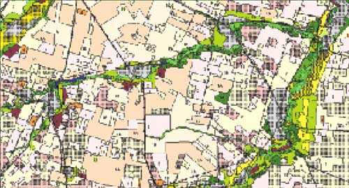
Land cover maps constitute a necessary tool for development planning and management of the territory. Furthermore, land cover maps depicting the current reality are a must in countries where, due to political changes, rapid dynamic phenomena have taken place, resulting in a complete restructuring of the agricultural and other sectors, as in the case of Bulgaria. The scale of such maps should be large enough to provide detailed information; however it should allow for regional assessment, statistics and subsequent planning. The 1:50 000 scale is the most suited for this exercise.The FAO project TCP/BUL/8922 “Strengthening Capacity in Agricultural Development through Remote Sensing and GIS” has produced 14 land cover maps at 1:50 000 scale for selected test areas of the country, covering 5 600 km2. These maps were prepared using Landsat satellite data, acquired in 1998 and 1999 as the main data source, and thus represent the land cover existing at that time. The land cover classification was performed using the FAO Land Cover Classification System (LCCS).
To each mapped unit (polygon), soil type and erosion features were linked as attributes into the GIS system. This created a comprehensive database, which is unique in Bulgaria. The database provides very useful information for agriculture, forestry and urban development planning, for environment protection and for many other applications. The data collected in the database provide the possibility for different kinds of spatial analysis, which is necessary in land management.
TC/D/Y0785E/1/7.01/500
Preparation
of land cover database of Bulgaria through remote sensing and GIS, by C. Travaglia,
L. Milenova, R. Nedkov, V. Vassilev, P. Milenov, R. Radkov, Z. Pironkova,
57pp,
11 figures, 4 tables, 1 annex, Environment and Natural Resources Working Paper
No. 6, FAO, Rome, 2001
1.1. Objectives of the project
1.2. Expected results
1.3. Test areas descriptionMontana test area
Sofia test area
Plovdiv test area
Sandanski test area
2.1. Satellite data selection
2.2. Satellite data pre-processing
2.3. Satellite data classification
2.4. Satellite data interpretation and vectorization of the resulting units
2.5. LCCS classification
2.6. Field checking
2.7. Composition of final land cover maps
2.8. Generation of the GIS database
2.9. Metadata
3.1. Land cover maps at scale 1:50 000
3.2. Land cover map at scale 1:5 000
3.3. State of vineyards/orchards for part of Sandanski region
3.4. Estimation of surface coverage of winter crops and grassland
3.5. Creation of DEM and slope class map
3.6. Statistics by administrative unit