![]()
![]()
![]()
Overview of land and water resources
information systems (LWRIS) in FAO
Over the last two decades the Land and Water Development Division (AGL) has been at the forefront of the development and application of computer-based data analysis and information systems to support decisions on various land and water issues . Soil and land as well as water systems have been developed. The soil and land systems focus on methodologies and tools for the assessment of global, regional, national and sub-national land resources potentials. The water systems concern irrigation water use and management at field level and regional and national water resources assessment .
AGL has been cooperating with various units within FAO and numerous international agencies and national institutions in developing and applying the systems.
Initially, in the late seventies and early eighties, the systems were developed for mainframe and mini-computers. From the late eighties they were gradually adapted to microcomputers. At the same time computer tools for managing spatial data, including geographic information systems (GIS), remote sensing and global positioning systems (GPS) were introduced. Since the last few years the availability of networked PC workstations, rapid application development and multimedia tools and the Internet have opened an era of new possibilities in the development and application of the systems.
Table 1 summarises some of the main issues related to sustainable land and water resources management which concern FAO.
Currently AGL systems comprise a set of tools to store and analyse information and generate and disseminate information products for land and water decision. The systems integrate tools of essentially five kinds (Figure 1):
|
Jacques Antoine |
These include database programme shells for the creation of soil, water, climate, crop and land use databases; and also some databases that have been created using the programmes. Geographic Information Systems (GIS) databases and analytical and visualisation tools for rapid production of information products are used to an increasing extent. GIS are useful because of three main qualities:
TABLE 1
Scales of land and water use planning and management
Level of analysis |
Scale 1) |
Issues |
Field/production unit (site specific) |
<1:5 000 |
Productive crops and animals; conservation of soil and water; high levels of soil fertility; low levels of soil and water pollutants; low levels of crop pests and animal diseases. |
Farm or village (local) |
1:1 000-1:50 000 |
Viable production systems; food requirements, economic and social needs satisfied; awareness by farmers. |
Country (national or sub-national) |
1:25 000-1:2 500 000 |
Judicious development of agro- ecological potential and use of irrigation water resources; drought and flood risks; food production and food security; conservation of natural resources and bio-diversity; land degradation; public awareness. |
Continent/world (regional or global) |
1:1 000 000-1:5 000 000 |
Land degradation and desertification; preservation of bio-diversity; water sharing; water pollution; population development and food security; climate change and agricultural potential; awareness of regional and global institutions. |
1A range of scales is indicated at each level of analysis. In practice the scale of an application is selected according to the extent of the area and the availability of maps.
FIGURE 1
Information and Decision-Support Systems in AGL
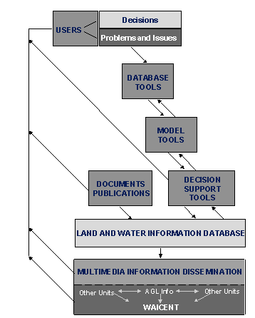
Models for crop growth and estimation of both potential and actual yields. Crop modeling has proved a valuable and multipurpose tool in land resources management, which can assist in the estimation of crop yields and the prediction of crop shortfalls due to environmental hazards.
Models for water balance, crop water requirements and irrigation requirements. Water modeling is an essential tool of quantitative assessment of water resources for the purpose of planning and managing the efficient use of the resource.
Remote sensing techniques to characterize and map land cover, and land use patterns and to evaluate and monitor soil and water resources. Remote sensing techniques offer a unique way of quickly assessing land cover and the situation and trends in implementing land management plan. In particular, they can be used to detect biophysical degradation of the land due to improper use or mismanagement. Remotely sensed data can be integrated with other data layers stored in a GIS to derive various kinds of maps, such as of soil moisture condition or land degradation.
Expert systems tools to provide advice on deciding on land and water use and management options, based on available information and knowledge.
Multi-Criteria Decision Support (MCDS) to analyse optimal land and water use scenarios. MCDS tools facilitate interactive negotiations on land and water use. This is because feasible real-world solutions in interactive negotiations are compromise solutions resulting from trade-offs between various conflicting objectives, in order to find an efficient and acceptable balance between the requirements of the different stakeholders in the land and water resources.
AGL has a documentation centre that collects and maintains two kinds of documents:
The AGL Documentation Centre uses an adaptation of the ISIS software to manage its database. The Centre has a direct link with FAO's main Library databases (FAOBIB and SERIAL) and uses on-line Virtual Library databases (AGRIS, CABI, etc.) for more comprehensive searches; lends and internally circulates documentation, books and serials; and disseminates information and publications produced by AGL.
AGL uses Internet and Intranet facilities to disseminate information under the umbrella of the World Agriculture Information Centre (WAICENT), FAO's corporate information dissemination system. In this way AGL reaches its target audiences more effectively at reduced processing costs in all phases of receiving, treating and disseminating land and water information.
AGL takes advantage of the three principal interactive and complementary components of WAICENT:
FAOSTAT, for the storage and dissemination of statistical information,
FAOINFO, which covers hypermedia information (text, images, audio and video), and
FAOSIS covering specialized information systems.
In particular AGL uses the services of the FAOINFO Group of WAICENT to prepare the textual, graphic, statistic and tabular information to be placed on the Web.
There are three kinds of systems, corresponding to the three areas of applications mentioned above:
Details of the information systems are provided at the following internet site:
http://www.fao.org/WAICENT/FAOINFO/AGRICULT/AGL/Aglhomep.htm
Six systems are selected and described below.
The SDBm Plus : FAO-CSIC Multilingual Soil Profile Database is being developed by the Consejo Superior de Investigaciones Cientifícas/ Instituto de Recursos Naturales y Agrobiologia de Sevilla (CSIC/IRNAS) with the collaboration of AGLL through a joint project. Its development is funded mainly by the Spanish Ministry of Environment through the programme SEIS.net: Sistema Español de Informacion de Suelos sobre Internet. Some financing is also provided by AGL through a letter of agreement with CSIC/IRNAS. SDBm Plus is a component of AGLL computer-based decision support tools for land resources analysis. This new database draws on the SDBm database previously prepared jointly by FAO, CSIC and ISRIC (International Soil Reference and Information Center, the Netherlands). SDBm itself was based on a programme called SDB, the original version of which was developed by FAO and ISRIC in the late 1980s.
SDBm is a collection of programmes incorporated into a menu-based interactive user interface to enter data and manage the database. Data storage is greatly facilitated by the multilingual function providing help menus in English, French and Spanish.
SDBm is a database tool useful for storage of primary soils information assembled at national level, or data collected in subnational or local soil surveys. SDBm data are used in the computerised AEZ land evaluation systems.
Soil scientists, land evaluators, agricultural extension officials and environmental modellers.
Calculation of weighted averages or dominant values of selected variables by soil unit, depth range and group of soil profiles; graphic presentation of soil analysis data, such as pie chart image of relative percentages of selected groups of attributes in a given soil profile.
Soil profile data: location and soil physical and chemical properties.
AGLL in collaboration with CSIC/IRNAS, through letters of agreement
SDBm has been extensively tested in the field and quality assessment carried out through user feedback.
Dbase
JBM compatible PCs
MS-DOS (Windows Beta version now being distributed (End of December 2000) Clipper 5.2, C)
CD-ROM
About 100 worldwide
At least 500 copies on diskette sold or distributed by FAO. New Windows version distributed on CD-ROM and downloadable from FAO and CSIC/IRNAS web sites.
AGLL in collaboration with CSIC/IRNAS
1990
English, French and Spanish
Provide spatial interpolation and mapping capability.
URL: http://www.fao.org/WAICENT/FAOINFO/AGRICULT/AGL/agll/infotech.htm#sdbm
WOCAT's mission is to provide tools that allow Soil and Water Conservation (SWC) specialists to share their valuable knowledge in soil and water management, that assist them in their search for appropriate SWC technologies and approaches, and that support them in making decisions in the field and at the planning level.
WOCAT was established as a global network of SWC specialists. It is organized as a consortium of national and international institutions and operates in a decentralized manner. (core members are CDE - Centre for Development and Environment, University of Bern; DLD- Department of Land Development, Ministry of Agriculture and Cooperatives, Thailand; FAO; ISRIC- International Soil Reference and Information Centre, The Netherlands; OSS - Observatoire du Sahara et du Sahel, Tunisia; and RELMA - Regional Land Management Unit, Kenya)
A set of three comprehensive questionnaires and a suite of databases have been developed to document all relevant aspects of SWC technologies and approaches, including area coverage. These tools have been tested in many workshops worldwide, and they have been systematically optimised for five years through application in a context of international expertise. WOCAT results and outputs are accessible via the Internet, in the form of books and maps, or on CD-ROM.
The WOCAT knowledge base is in the public domain, i.e. everyone is invited to share it and use it. The WOCAT network is open to all individuals and organizations with a mandate or an interest in SWC.
WOCAT Technologies Database (this is the major part of a suite also including the WOCAT databases: WOCAT Approaches Database, WOCAT Images Database, WOCAT Addresses Database).
At the field level, SWC specialists work under very different bio-physical, socio-economic and institutional conditions. They search for SWC technologies successfully practised elsewhere under a set of similar conditions. Querying the WOCAT Technology database will return technologies that are most likely adaptable to their specific situation and needs.
Soil and Water Conservation (SWC) specialists and decision makers searching for appropriate SWC technologies and approaches supporting them in making decisions in the field and at the planning level
The query system provides access to SWC technologies at various points. The 27 search criteria (21 criteria in the www-version) comprise, for example, agro-ecology, climatic and slope conditions, degradation processes to be tackled, farming systems, cost and input levels. Thus, a choice can be made among relevant SWC options.
Presently, the results of approx. 50 SWC Technology questionnaires (mid 2000).
Soil and Water Conservation Technologies data are gathered during WOCAT workshops by means of an approx. 50 pages questionnaire. These data are then verified and entered into the WOCAT Technologies Database (MS-ACCESS version) and subsequently uploaded into Oracle via an automated procedure, thus becoming available in the www version.
CD-Version: MS-ACCESS 97
www-Version: Oracle
CD-Version: IBM compatible PCs
www-Version: FAO web server environment
CD-Version: MS-ACCESS 97
www-Version: HTML and ASP (Active Server Pages)
500 WOCAT CD-ROMs (version I) were produced in 1998 and distributed within weeks; distribution of the 2000 copies of the new version II started October 2000. Web access is not being monitored yet as the www.wocat.net site was not yet fully implemented before mid-January 2001.
AGL in Cooperation with the Centre for Development and Environment of the University of Berne, Switzerland
Data collection of SWC questionnaire data started approx. 5 years ago as a set of MS-WORD documents. The first WOCAT database was presented 2 years ago. The www version was introduced this year.
CD-version:Trilingual, English, French, Spanish
Web-version: English only
Trilingual web version
URL: http://www.fao.org/WAICENT/FAOINFO/AGRICULT/AGL/agll/wocat.htm
3. AQUASTAT - Information system on water in agriculture and rural development
In 1993, FAO initiated an activity to meet the considerable demand for data on rural water use from national governments and development agencies. This resulted in the AQUASTAT Programme, the objective of which is to generate data at country and sub-country level in a systematic and standard form. The programme currently contains data on Africa, the Near East, Former Soviet Union, Asia, and Latin America and the Caribbean.
AQUASTAT
The system presents a description of the rural water situation in Africa, Near East, Former Soviet Union, Asia and Latin America and the Caribbean. The information is presented as regional surveys and country profiles in 5 FAO-publications containing charts, tables, graphs and maps. All information, except for the survey on Latin America and the Caribbean is also available on the World Wide Web.
FAO and other international agencies, academic institutions and general public.
Provides information on the state of water resources and use at global, regional and country level in relation to agriculture and food security
More than 100 variables on water resources, irrigation and drainage
Ad-hoc by AGLW officer and feed-back from the field.
HTML / Oracle (planned)
Web server
HTML
Through FAO publications and on the Internet
AGLW
1995
English, French and Spanish (planned)
Global directory on institutions dealing with water in agriculture; coverage of OECD-countries; statistical and query functions; expansion of the system through on-line map viewing and map query facilities.
URL: http://www.fao.org/ag/AGL/aglw/aquastat/aquastat.htm
4. Gateway to Land and Water Information
The World Food Summit in November 1996 and the 15th session of the FAO Committee on Agriculture (COAG), in January 1999, emphasized the importance of land and water resources assessment and monitoring at all levels for food security and Sustainable Agricultural and Rural Development (SARD).
FAO needs to monitor and project the capacity to produce the food required in the future at regional and global levels, and also the domestic potential in the least developed countries with inadequate food supplies and limited market demand. Member countries and the international community need consistent and easily accessible information for assessment of the situation, projections and decisions. Country-level information on land and water is the foundation for national planning and also provides the building blocks for regional and global systems monitoring food security and the health of the planet.
This information must not only be gathered but also transferred to the users, including decision makers, planners, scientists and rural land users. The COAG committee recognized the need for periodic reporting on the State of The World's Land and Water Resources, synthesising information from the vast amounts of existing data, maps, statistics and documents. Such reporting should enhance awareness about land and water development problems and facilitate decisions on the sustainable use of land and water.
It is the primary responsibility of Member Nations themselves to collect information and prepare the reports. FAO has a role in supporting methods and data standards, ensuring consistency of information and promoting the exchange and dissemination of information.
This is the context within which the Land and water Development Division of FAO (AGL), as part of its normative programmeme, is collaborating with other FAO units, national institutions and other partners in building up this land and water information Gateway.
The Gateway is designed as a globally networked information base on the present use and the trends in use of land and water resources in relation with food security.
It is meant to contain national and regional reports on the state of land, water and plant nutrition resources management in FAO member countries. The reports are compiled in the form of a digital atlas to be made available through the Internet and on CD-ROM.
The reports are addressed to FAO Governing bodies, planners and decision makers in Government ministries, donor agencies, researchers and University students, but also to the public at large.
The Gateway has two functions:
Text, maps, charts, tables and photos.
AGLL maintains and updates FAO internal links and global links and organises such links. The network institutions are responsible for updating the national and regional information, and together with users are expected to participate in amplifying possible new links by using the feedback function of the site.
AGLL assists in reviewing reports prior to posting on the sites. The feedback function of the AGLL site is also intended for gathering comments and suggestions on improving the quality of the reports.
Various
IBM compatible PCs
Windows NT and Windows 95/98
HTML 4.0
Internet
Potentially: 10,000-20,000 worlwide
Number of hits at FAO site: 500/month
AGLL in collaboration with participating network institutions
1999
English and Spanish, (French in preparation). Country reports in several languages
The Gateway site has recently been redesigned and is continually being upgraded to increase interactivity and access to information and improve information quality standards. It is planned to gradually expand the network to include most countries in Africa, the Near East, Latin America and the Caribbean, Asia and the Pacific Islands.
URL: http://www.fao.org/WAICENT/FAOINFO/AGRICULT/AGL/swlwpnr/swlwpnr.htm
5. AEZWIN :Agro-Ecological Zoning System
Since the early 1980s, FAO and the International Institute for Applied Systems Analysis (IIASA) have been collaborating on expanding FAO's Agro-Ecological Zones (AEZ) methodology of land resources appraisal by incorporating computer-based decision support tools for optimizing the use of land resources. Agro-ecological zoning involves the inventory, characterization and classification of land resources for assessments of the potential for agricultural production systems.
This effort culminated in the publication in 1994 of AEZ software for MS-DOS PCs for national and sub-national applications, based on a Kenya AEZ study. The decision support tools included in the software consisted of the application of linear optimization techniques for analysing land use scenarios with regard to single-objective functions, such as maximizing agricultural production or minimizing the cost of production under specific physical environmental and socio-economic conditions and constraints.
AEZWIN is an upgraded, multi-objective version for WINDOWS 95 and NT of the Kenya AEZ software.
AEZWIN is an interactive multi-objective and multi-criteria analysis tool for land resources appraisal. When evaluating the performance of alternative land utilization types, often the specification of a single objective function does not adequately reflect decision-makers' or stakeholders' preferences, which are of a multi-objective nature in many practical problems dealing with resources. AEZWIN implements interactive multi-criteria model analysis (MCMA) in the analysis of AEZ models.
The software package is a specialised tool meant primarily for two kinds of use:
Land use specialists, agricultural and environmental planners in Government ministries and research institutions, University teachers, students and researchers.
The software incorporates the FAO AEZ methodology, a Linear Programmeming package and a multi-criteria analysis tool. The AEZ models are applied on a land resources database to analyse potentials of land for various kinds of use. The main functions include: database management, calculation of length of growing period, irrigation requirements, crop biomass, land suitability and productivity analysis, multi-objective and multi-criteria optimization.
AEZWIN databases integrate various kinds of geo-referenced data sets generated using a GIS, and which can include the following:
AGLL in collaboration with IIASA, through letters of agreement
The software has recently been reviewed by two visiting scientists and is continually assessed through user feedback.
IBM compatible PCs
Windows NT and Windows 95/98
FORTRAN and C++ and GIS (IDRISI)
Off-line
About 50 (estimated) worldwide, but number continuously increasing
At least 700 CDs sold or distributed by FAO. Number of hits at FAO and IIASA sites from where the software can be downloaded still to be determined
AGLL in collaboration with IIASA
1991
English
The software reviews show that there is a need to:
Future development of AEZWIN depends on the possibility of further collaboration with IIASA or other partners. AGLL does not have the in-house capability to maintain alone such a complex package.
URL: http://www.fao.org/WAICENT/FAOINFO/AGRICULT/AGL/agll/aez.htm
6. GAEZ - Global Agro-ecological Zones 2000
Documented methodology to evaluate the productive capacity of the land resource based on its soil, terrain and climatic characteristics, applied to the whole world. Many data, maps, pictures etc.
Crop growth simulation modellers, Universities, regional and environmental planners. Perspective studies on agriculture, food security, global climatic change.
Provides a global inventory of (agro)climates, soil and terrain conditions and evaluates land resources potential and constraints and productivity possibilities for more than 250 combinations of crop and management level.
Global Soil and terrain constraints for agriculture. Global Climatic data parameters. Potential productive land by country. Suitability for each crop considered by country. More than 100 maps and tables downloadable and compatible with report and GIS (IDRISI/Arc/INFO) requirements
Jointly with IIASA. Will only be undertaken if one of the major layers is updated (climate or soil most likely).
Feedback from users. Earlier models tested. Quality depends partly on resolution and base material which can only be improved slowly. Warnings included.
Most maps are in bnm format and can be viewed on screen, all tables are in EXCEL. All maps also come in Arc/Info and IDRISI compatible formats.
Pentium PC with Windows 95/98/NT with browser installed.
GIS software (IDRISI or Arc/Info for maps)
On CD-ROM and via web, both IIASA and FAO: http://www.fao.org/WAICENT/FAOINFO/AGRICULT/AGL/agll/gaez/index.htm
http://www.iiasa.ac.at/Research/LUC/GAEZ/index.htm
Number of users
Potentially 5 - 10 000 scientists plus organizations such as World Resources Institute, IFPRI, World Bank.
1500/month (IIASA website since August)
AGLL and IIASA
August 2000 on the web. December 2000 on CD ROM
English only
A number of related products are being prepared for additional data release and for publication as a FAO Soils Bulletin and IIASA Research Bulletin.
The AEZ system has been applied in various countries in the last two decades. An example of a current application in a Latin America regional project can be viewed in a slide show on the AGL web site at the following address:
http://www.fao.org/WAICENT/FAOINFO/AGRICULT/AGL/lwrisdoc.htm
![]()
![]()
![]()