![]()
![]()
![]()
GIS applications for agricultural planning in Bangladesh
In the period 1980-1987 a national Agro-Ecological Zone (AEZ) database was successfully developed in Bangladesh. The database contains information on the country's land resources, including physiography, soils, climate, hydrology, cropping systems and crop suitability. The database is housed in the Bangladesh Agricultural Research Council's (BARC) computer center at Dhaka, Bangladesh. It has been used to generate readily accessible information on the physical land resources of the country for use by researchers, extension workers and decision makers in land and agricultural resources management as well as agricultural development planning.
The AEZ database constitutes the foundation for a new effort to develop a comprehensive multiscale GIS-based Land Resources Information System (LRIS). This system is designed to better deal with the intricacies of land resource planning under the complex environmental conditions that prevail in large parts of Bangladesh. The LRIS includes additional databases and procedures, in particular data on socio-economic and demographic factors influencing agricultural production. The system is being implemented by BARC with financial support from the United Nations Development Programmeme (UNDP) and technical support from FAO.
The technology being used to establish the LRIS includes ArcView GIS, the ArcView Spatial Analyst and Dialog Designer extensions, and Avenue, ArcView GIS software's programming language, as well as multicriteria analysis tools.
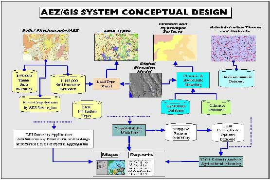
At the start of the new development efforts in 1997, an overall system design (Figure 1) was established to allow for a dynamic analysis and modeling capability. In the past, natural resources modeling systems were based on static GIS overlays. Due to the limited capacity of computers at the time, the overlay of individual maps, such as soil, climatic and flood zones was cumbersome and much time was needed to refine the resulting layer. With the advent of more powerful desktop computer systems and more powerful software tools, such as ArcView GIS and ArcView Spatial Analyst, it has become possible to develop more flexible and dynamic modeling tools.
The approach taken in Bangladesh is to create a dynamic multilayered GIS database in which the component layers are modeled as variables that change over time. Due to the inherent variability of climatic and hydrologic conditions in Bangladesh, an open-ended system that
Michael D. Broten |
allows for modeling of a wide range of dynamic scenarios, from the historical record as well as predicted future scenarios, will be of greater use and will yield higher quality results than a static system.
The land resources inventory (LRI) application allows for the classification and mapping of soil characteristics from the LRI database. The LRI contains several attributes describing physical soil characteristics. Since LRI attribute data have a many-to-one relationship to soil mapping units, the data must first be summarized by mapping unit and the resulting mix of LRI characteristics classified for mapping purposes.
FIGURE 1
AEZ/GIS system conceptual design
The LRI Summary Application was developed using the ArcView Dialog Designer extension. It allows the user to specify the study area, the data to be classified, and the number of classes to be created. The user is then able to edit the resulting mix of classes based on the percentage area covered by each class. Classes can be merged and renamed to provide for more effective map output.
The output of this application is a new grid-based Soil Inundation Land Type layer in which the number of many-to-one relationships between soil attributes and soil mapping units is greatly reduced.
An ArcView GIS-based application has been developed to dynamically combine a user-specified digital elevation model (DEM) with the national (reconnaissance level) soil association layer to create a more detailed "Soil/Inundation Land Type" layer. The application is written in Avenue and uses the ArcView Spatial Analyst extension. It has been programmemed to handle future updating of both the soil and the DEM layers.
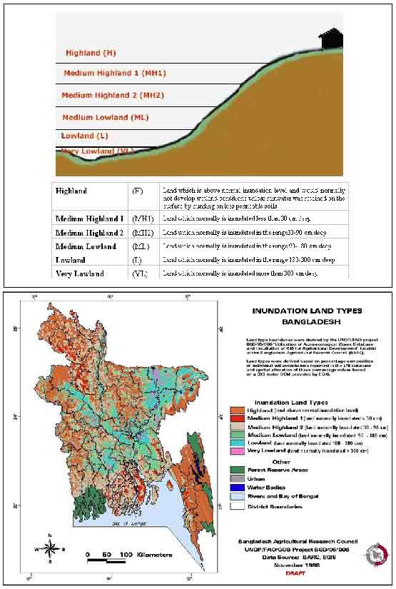
The first step in development of this application was to refine a previously generated 300-meter DEM by filling in areas of missing elevation with values taken from a 1,000-meter DEM. Then, an Avenue programme was written to assign soil association- and topographically-derived "inundation land type" designations to each 300-meter grid cell. In Bangladesh, the following designations are used to specify a range of inundation depths based on the average peak water depth: highland, medium highland 1 and 2, medium lowland, lowland, and very lowland (Figure 2). This new layer provides for a more explicit, accurate, and dynamic soil mapping capability.
A database containing detailed information on the various cropping systems of Bangladesh has been created by this project. The database lists the cropping pattern details within each of the physiographic sub-zones of the country. Details include the approximate planting and harvesting dates for each crop, the inundation land type on which it is grown, and whether the crop is irrigated.
A GIS application named "CropViewer" was created to provide a GIS-based interface to this database. It allows the user to view the spatial distribution of each cropping pattern within a given sub-zone or for the entire country. It also "looks-up" the full name of the numerically coded crops and can create detailed maps showing the distribution of each crop.
The system includes a component that permits the evaluation of crop suitability. First, individual crop suitability ratings are analysed and then suitabilities for various cropping patterns are rated using a database of known and potential cropping patterns (rotations). This suitability modeling takes into account individual crop characteristics, input/management levels, soil physical characteristics, hydrologic and climatic conditions, and seasonal variability. Extrapolations of existing cropping system technologies can also be made to delineate suitable areas on a national scale.
The ArcView Spatial Analyst and Dialog Designer extensions are used for the crop suitability modeling. A main dialog allows the modeler to specify thematic layers and other options associated with each model run.
Much effort has been devoted to expand existing historical climatic data with recent records obtained from various institutions. Procedures have been developed to perform quality control and enhance database management and modeling capabilities. Meteorological station data are analysed using the APT (Agricultural Planning Tools) calculator and the resulting data are used to create GIS surfaces showing important climatic properties related to plant growth by season, such as the average starting date of the kharif (monsoon) growing seasons, as well as the variability of these properties.
On average, about 60 to 70 percent of Bangladesh is inundated by rising water table levels between July and September of each year. Previous AEZ assessments indicated that the year-to-year variation in inundation regime is affecting long-term suitability and productivity of land. The enhanced system now in place enables quantification of year-to-year variation in extent, depth and timing of inundation. This information will greatly improve the suitability assessment of individual inundation land types for single crops and cropping patterns.
Another primary goal of this project is the analysis of land use scenarios integrating the physical suitabilities for various cropping patterns and socio-economic factors of agricultural production. Relevant socio-economic and farming system databases are being constructed for this purpose. The analysis will involve three steps: the formulation of scenarios, each scenario represented by a core model; the analysis of solutions of the core model using a linear programming solver based on multi-objective linear optimization; and the application of multicriteria analysis to the core model solutions to determine compromise solutions that adequately reflect the preferences of decision-makers in real-life situations. Various software tools have been put in place for this application, and GIS plays a pivotal role in all aspects of this work.
FIGURE 2
Inundation land types
![]()
![]()
![]()