![]()
![]()
![]()
Cuba is the largest island in the West Indies and is also the westernmost-just west of Hispaniola (Haiti and the Dominican Republic), and 145 km south of Key West, Florida, at the entrance to the Gulf of Mexico. The country also includes 4195 smaller islands, islets, and cays. The island is 1 250 km long and its width ranges from 32 km at its narrowest point, to 210 km at its widest. It is mountainous in the southeast and south-central area, Sierra Maestra, and flat or rolling elsewhere. Total land area is 110 922 km2. There are about 11 million inhabitants with an annual growth rate of 0.5 percent and a population density of 99.6 persons per km2. Approximately 2.2 million persons live in the capital, Havana. The country is divided into 14 counties. Mean annual rainfall is 1375 mm and mean annual temperature is 25°C.
The National CLAWRENET comprises the Instituto de Suelos, Instituto de Riego y Drenaje, Instituto de Investigaciones Forestal, Instituto de Agraria de la Habana, CENICA, La Agencia del Medio Ambiente and the Instituto de Meteorología. The Instituto de Suelos is the lead institution, providing the scientific base for the sustainable use and protection of soils in the agricultural sector. Its main functions are the execution or participation in research and development projects linked to the agricultural sciences and the protection of natural resources and the environment. The Institute also offers technical and methodological soil services on soil and fertilizer use. Research is also conducted in soil genesis, classification, cartography and evaluation, as well as soil conservation, agricultural management, soil fertility and biology. There are soil research stations located throughout the country as well as provincial technical and soil analytical services.
The main scientific results of the Institute include national soil maps at scales of 1: 250 000, 1: 50 000 and 1:25 000. Detailed maps have also been drawn to characterize soil fertility and fertilizer recommendations for the main crops; soils affected by erosion, salinity, compaction, acidity and poor drainage; as well as methods to improve these problems.
The Institute has developed technologies for the production of organic manures from industrial domestic and agricultural solid wastes and for the production of biological fertilizers such as Rhizobium and phosphate solubilizers. Additionally, to enhance soil physical properties,
Sigfredo
Hernandez-Ortega |
the Institute promotes minimum tillage technologies based on the use of the horizontal cutting plough and technologies to restore degraded soils and vegetation at the river basin and watershed levels.
The main factor contributing to natural resource degradation in Cuba is low soil productivity caused by salinity, sodicity, erosion, poor external and internal soil drainage, low fertility, compaction, low organic matter content, low soil moisture retention, rockiness and stoniness. Table 1 shows the extent of these land degradation problems in the island.
TABLE 1
Total soil area affected by soil degradation processes
|
Limiting Factor |
Area affected (million ha) |
Percentage of Agricultural area |
|
Salinity and sodicity |
1.00 |
14.9 |
|
Erosion (strong and medium) |
2.90 |
42.2 |
|
Poor drainage |
2.70 |
40.3 |
|
Poor internal drainage |
1.80 |
26.9 |
|
Low fertility |
3.00 |
44.8 |
|
Compaction |
1.60 |
23.9 |
|
Acidity (pH KCl < 6) |
1.66 |
24.8 |
|
(pH KCl < 4.6) |
0.47 |
7.00 |
|
Low organic matter content |
4.66 |
69.9 |
|
Low water retention |
2.50 |
37.3 |
|
Stoniness and rockiness |
0.80 |
11.9 |
Salinity is caused by unsuitable management of the saline water table, overexploitation of subterranean water, poor drainage systems and inappropriate soil management techniques. Low adoption rates of soil conservation measures, deforestation, shifting cultivation, poor land management and overgrazing are the main reasons for soil erosion. Poor drainage is attributable to natural and artificial soil water drainage, lack of geographic studies which consider the watershed as a unit in which to establish irrigation and drainage systems and low rates of rectification of drainage systems. Inappropriate use of agricultural machinery, continuous tillage at a constant depth, overgrazing and inadequate use of irrigation systems are the main causes of soil compaction.
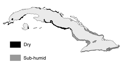
FIGURE 1
Dry and Sub-humid Zones of Cuba
Soil organic matter is reduced by erosion processes, lack of incorporation of crop residues in the soil, burning, low application rates of organic matter and inappropriate crop rotations. Low soil fertility is generally due to monocropping, indiscriminate use and application of inorganic fertilizers, overexploitation of soils by crops which impoverish the soil and little use of sustainable agricultural practices. This poor soil management also results in soil acidity.
Fourteen percent of Cuba's total land area, approximately 1.58 million ha, is also affected by dry conditions and threatened by desertification. These dry conditions are distributed over 24 climatic zones as shown in Figure 1.
Table 2 shows the areas and periods of execution of measures against the factors which contributed to land degradation.
TABLE 2
Periods of execution and extent of reclamation and improvement measures
MEASURE |
TIME PERIOD |
AREA (thousand ha) |
Soil Erosion |
|
|
Simple anti erosion measures |
1986 - 99 |
839 |
Planting on the contour |
1997 - 99 |
314 |
Planting perpendicular to the slope |
1986 - 99 |
634 |
Live barriers |
1986 - 99 |
72 |
Dead barriers |
1989 - 99 |
298 |
Live ground cover |
1986 - 99 |
160 |
Dead ground cover or plastic mulch |
1992 - 99 |
191 |
Dams |
1087 - 99 |
45 |
Terraces using ploughs |
1989 - 99 |
38 |
Individual terraces |
1993 - 99 |
66 |
Maintenance and complementing measures |
1992 - 99 |
40 |
Other measures |
1992 - 99 |
175 |
Salinity and Poorly Drained Soils |
|
|
Control of quality of irrigation water |
1986 - 99 |
23 396* |
Application of gypsum |
1987 - 89 |
1.6** |
Simple drainage on parcels of land |
1987 - 99 |
157 |
More technical drainage on parcels of land |
1987 - 99 |
19 |
Modernization of rice |
1988 - 95 |
7 |
Levelling |
1986 - 99 |
372 |
Soil Compaction |
|
|
Subsoiling |
1986 - 99 |
466 |
Minimum tillage |
1986 - 99 |
1064 |
Soil Acidity |
|
|
Calcareous amendments |
1976 - 99 |
1697 |
*Springs
**Million Metric tonnes
Cuba uses a multidisciplinary approach to generate integrated natural resources management methods and these methods are used on the basis of hydrographic units. Researchers are currently working to develop an indicator to evaluate the true extent of natural resource degradation.
Other areas of work are the development and introduction of technologies to harvest and manage rainwater for agricultural and domestic use and the training of farmers and civil society by applying appropriate regional agricultural extension methods.
The application of GIS to evaluate and process available data for a more rapid response to the problems and to follow the evolution of the effects of applied practices is also important.
![]()
![]()
![]()