![]()
![]()
![]()
Thierry
Bélouard
National Forest Inventory, Lattes,
France
Frédéric Coulon
Solagro Association, Toulouse, France
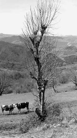
Photo 49. Pruned tree in Auvergne, France (© Bellefontaine/Cirad)
In the aftermath of World War Two, food self-sufficiency became the prime target of French agriculture. Farm mechanization developed as a means of intensifying production, with land consolidation as an instrumental component of mechanization. The ensuing rise in productivity was such as to produce agricultural surpluses and drive a rural/urban exodus, reinforced by the pull of the city lights. Compared to the year 1936, when half of the people of France lived in the countryside, three-fourths of today's population are now urban.
In this new farm context in which production had become more highly specialized, a great many agroforestry practices fell into disuse. Trees outside forests now cover only 1.7 million ha - which is three percent of the land area, compared to 4.5 million ha at the turn of the twentieth century. Nonetheless, trees remain remain a major component of the rural landscape, and as such are inventoried. They have gained renewed legitimacy from their environmental role and scenic impact, which is reflected in official policy and in the implementation of programmes to promote trees outside forests and support reforestation. The inventory of these tree systems under the NFI (National Forest Inventory - inventaire forestier national) is an illustration of efforts to boost awareness among stakeholders on this issue.
The two main entities monitoring trees outside forests in France are the NFI, which has been inventorying them since 1998, and SCEES, the Central Bureau of Surveys and Studies (Service central des études et des enquetes), which has been running the Teruti land use survey, (Utilisation du territoire), since 1981. A typology2 of Trees outside forests was established based on these sources:
The changing pattern of trees growing in non-forested areas of France is reflected in the various inventories done since the 1960s.
Hedgerows and scattered trees: The aggregate figure for hedgerow length dropped from 1 244 110 km to 707 605 km between 1975 and 1987 (Pointereau and Bazile, 1995). Hedgerow regression, repeated in 1981-1990, seems to have tapered off since 1992 to an annual figure of less than 0.3 percent (SCEES, 1999). A similar trend is reported for scattered trees. Found on 342 500 ha in 1998: the drop was less than 3.6 percent between 1993 and 1998. Trees planted in the last 20 years have not yet offset the large-scale elimination of scattered trees and hedgerows between 1960 and 1980.
Agroforestry areas: from 1982 to 1990, fruit-tree meadows shrank by nearly 20 percent, then by 30 percent from 1991 to 1998, and now cover only 163 000 ha. The Lower Normandy region lost 63 percent of its tree orchards from 1963 to 1990, a total of 8 million trees. At that rate, this type of formation would disappear by 2020. Moreover, tended walnut, olive and chestnut groves now cover only 36 000 ha, compared to a figure of 265 000 in 1929.
Roadside trees: the aggregate linear length of roadside trees fell by 23 000 km from 1975 to 1987. This 42 percent drop amounted to some 3.5 million trees. While there has been a reported 14 percent increase in trees bordering roads since 1992, the frailty of this aging legacy is heightened by security constraints. It is also inadequately managed.
Agricultural modernization accounts for 52 percent of the drop in Trees outside forests. Land consolidation to facilitate mechanization has affected over 15 million ha since 1945. And 2.7 million ha of grasslands have been brought under the plough since 1970. Farm subsidies under the Common Agricultural Policy (CAP) for cereal crops favoured this transformation. At the same time, the "disappearance" of 40 percent of non-forest trees is attributable to agricultural set-asides and the incorporation of hedgerows into forest lands and wooded moors. Lastly, a small (eight percent) portion of this shrinkage can be traced to urbanization (Pointereau and Bazile, 1995). Because French forestry resources are not fully exploited, the development of off.forest tree systems is not encouraged. And though it contributes to the economy and helps to sustain ecosystems, this largely self-consumed or bartered resource appears to be part of an "underground economy".
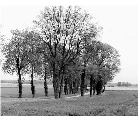
Photo 50. Trees lining rural roads are also under threat from agricultural intensification in France. (© Bellefontaine/Cirad)
Farmers report a harvest of 4.4 millions m3 of wood from hedgerows, which approaches the annual 4.5 million m3 annual output of Trees outside forests (Solagro, 1997. This amounts to 620 000 TOE/yr3 , or 11 percent of domestic fuelwood consumption. Not counted in this estimate are hedgerows harvested by private individuals and undeclared volumes of output. It would appear that TOF contribute some five percent of the total ouput of wood, although this is marginal lumber due to poor maintenance such as tree wounds or poor pruning, which compromises the quality of the product.
Fruit-tree meadows are a productive agricultural system. The traditional fruit-tree meadows of Lower Normandy supply 40 percent of the output of cider apples. The total figure comes to 300 000 tonnes and involves over 13 000 farmers. The income generated by a fruit tree orchard is four times that from a grassland in terms of milk and meat (Nevoux, Opezzo and Richert, 2000). Mirabella plum production was relaunched in Lorraine in the 1980s, and since then 200 farmers have successfully developed or maintained a product which brings in 30 to 40 percent of their income and diversifies their output as well.
Agricultural consolidation and intensification have also been a factor in erosion, yet another proof of the prominent role of trees in the protection of water and soil resources. In the Yonne watershed, the ploughing-under of grasslands and elimination of hedgerows halved the volume of ground storage water (Baumann, 1983). Flooding is more severe now and low-water discharge has fallen (Mérot et al, 1976). Rows of trees growing along water-courses (riparian buffers) improve water quality and take up 70-100 percent of the nitrates contained in surface waters and runoff, which amount to 900kg/ha of nitrogen each year (Hickie et al, 2000).
Windbreak hedgerows have a demonstrably beneficial agricultural impact, producing better and earlier yields and protecting crops. Trees outside forests have had a comparable impact on soil fertility (Hickie et al). They also help maintain biodiversity among bird populations (Moore, 1976, cited in Pointereau and Bazile, 1995) and insects useful to farmers (Karg, 1989, Karg and Ryszkowski, 1991; Blab, 1988), aiding crop pest control (Scapotjev, 1976, cited in Pointereau and Bazile, 1995).
The parallel and growing demand by society for scenic landscapes provides an incentive to preserve off-forest trees, and trees are essential for farmers wishing to diversify by introducing farm hospitality and agritourism on their land. The occupation rate of rural lodgings is higher by 30 percent in a landscape criss-crossed by trees and hedges than in an open one bare of trees (Armel, 1994). Local authorities are encouraging such activities as part of a broader rural development trend.
The rules and regulations for trees outside forested areas are laid down in various laws. The Civil Code establishes the principles and rules for establishing, harvesting and eliminating hedgerows. The Forest Code, however, devotes little attention to non-forest wooded areas and takes no note of scattered trees or agroforestry areas. A growing number of laws, decrees and regulations designed to protect hedgerows have been issued as environmental protection components under the Code governing rural areas and the environment. Aid from the European Commission since 1992, a stronger law to protect nature, and the land use planning law are also pertinent here.
Trees growing outside forests are primarily administered and managed by the Departmental Divisions of Agriculture and the Forest (DDAF - Direction départementale de l'agriculture et de la foret). Together with forestry agencies such as the Institute for Forestry Development and the regional centres for forest ownership, and agricultural bodies such as the Chambers of Agriculture, they provide oversight for tree-planting. The Regional Divisions of the Environment (DIREN - Direction régionale de l'environnement) support projects to conserve and restore hedgerows and trees.
The DDAF have been increasingly active in the last five years in promoting non-forest tree systems. They established a rural management fund in 1995 (FGER - Fonds de gestion de l'espace rural), and land use contracts (CTE - Contrat territorial d'exploitation) in 1998, as a follow-up to agricultural/environmental measures enacted in 1992. Working with the DIREN, they also headed a campaign to promote Trees outside forests.
The administrative role of these bodies is evolving and changing. The management of non-forest tree resources in the last two decades was the responsibility of the forest or farm services, but now local groups such as regional councils and the regions themselves are initiating environmental policies. They have been given responsibility for financing hedgerow operations and managing land development efforts within their sphere of competence. They are encouraged to develop area projects such as land-use contracts and State-Region Plan contracts. Several departments have pooled their resources and drawn up charters to promote and accentuate attention to trees in land development schemes. Incentive policies for replanting or maintaining bocage hedges and rows of trees in the rural landscape are now underway in 80 percent of France's departments. One remaining weakness of these promotion policies, however, is the lack of research on off-forest tree resources. Very few scientific teams are focussing on the significance of on-farm trees, or the interaction between trees and crops, or that between trees, pasture and animals.
There is a growing trend to give greater responsibility for non-forest tree management procedures to local authorities, and priority to broadly designed, collective operations whose objectives are tailored to social or environmental targets, including awareness-building, protection, replanting, maintainance and enhancement efforts. Also favoured are tree maintenance initiatives by associations, towns or districts (sometimes grouped together), and by farmers, who are, in the final analysis, the prime managers of trees and hedgerows in non-forest areas. Group purchases of maintenance equipment are another option.
Orchards are also the target of specific action. The Rénova Federation established a programme in 1995 in Ariège and in Haute-Garonne to restore and enhance old-fashioned fruit varieties. The rural social fabric of these regions was under threat following the widespread abandoment of agricultural lands, and local authorities and farmers were looking for ways to preserve the local fruit-tree legacy. An awareness-building campaign was followed by rejuvenation pruning in over 300 orchards in the region. More than 50 farmers are now responsible for a high-quality cottage industry which has sparked such enthusiasm that farmers belonging to the Rénova network are now building a plant to process fruit into cider and juice. The target is 80 000 bottles by 2004. An experimental orchard programme to enhance never-before-studied local varieties is now in the planning stages.
As we saw in section two, the main statistical bodies in charge of assessing off-forest tree resources are the NFI and the land use survey. They are increasingly attuned to environmental concerns, identifying and implementing environmental indicators.
The NFI, headed by the agency of the same name, is designed to assess forest resources. Spurred by the growing importance of off-forest tree formations since the 1960s, the NFI undertook to parallel the general inventory with special inventories of hedgerows, line plantings and scattered trees in the relevant departments (Chevrou, 1988). Methods suited to each type of formation, based on the interpretation of aerial photos and ground plots, were adopted. The intersection method was adopted for inventorying linear formations such as hedgerows. Circular plot sampling was used for line plantings like poplars, which are usually found in the same geographical areas. A sampling method similar to that used for forest formations: point sampling with site-specific plots, was used for scattered trees.
In the late 1990s these three inventories were combined into a single, cost-cutting, inventory of trees outside forest areas, to better meet user needs without blurring the accuracy of the data.
The Teruti survey, begun by the surveys and studies service of the Ministry of Agriculture in 1981, monitors changes in non-forest treed areas and shows what is happening in wooded areas. It is based on a systematic two-stage sampling. The first stage is comprised of a systematic series of aerial photographs covering the entire country, overlain by a second stage made up of a 36 dot regular grid. Physical and functional use of the area is recorded for each point. The Teruti survey includes permanent sampling so that any change in land use patterns can be monitored.
Community-financed companion assessments to the NFI and the Teruti survey, which are both national in scope, now meet the needs of local communities, especially in western France. The DDAF did a 1995 inventory of existing hedgerows in Mayenne (cf. Annexe), where a former bocage landscape had been transformed by the elimination of hedgerows. Another survey done in Brittany sought to relate farming practices to water quality.
The NFI inventory of Trees outside forests covers formations not included in either the general inventory or in the poplar inventory. Excluded are orchards, vineyards, walnut groves and truffle sites. The inventory covers line plantings (distinguishing between poplars and other row plantings), hedgerows (tree and non-tree hedgerows), and scattered trees. Not included in the inventory are formations found on manmade sites (such as settlements or leisure areas), or sites where access is dangerous (such as busy highways and railway lines) or difficult (such as private properties and enclosed grounds).
The associated strips method used to inventory linear formations consists of attributing an area to the formation in question, in which a set of points is located at a distance of less than r from the formation, (r being roughly 25 metres). The length is then estimated by dividing the area by the length of the strip (2r, ). Practically speaking, circular plots with a radius of r are used: A hedgerow or other line planting is taken into account where the point in this formation closest to the centre of the plot belongs to the plot of the radius r, and is not one end of the formation. The method used for scattered trees remains unchanged: point sampling with a control plot.
A two-stage sampling method with stratification is used. Stage one consists of the photo-interpretation of points on aerial photographs (noting the clear presence, where possible, of the numbers and kinds of formations). Stage two consists of systematic ground monitoring, perhaps accompanied by a description such as configuration, environment, permeability, etc., and eventual tree measurements such as volumes and growth where external financing is available. Lastly, the statistical data are accompanied by confidence intervals (cf Annexe).
The inventory with its now fully operational design is currently being applied country-wide. It should afford a better response to user expectations because it addresses environmental concerns and tailors the detail of the data to local interests.
The lack of specific legal status for Trees outside forests can be a constraint to conservation where CAP subsidies apply to treeless areas, because most such trees are growing on farmland. The establishment of an agroforestry working group within the Ministry of Agriculture is a positive step toward broader discussion of the role and status of Trees outside forests. Bearing in mind the amenities trees offer to society, agriculture could come to be seen as providing services as well as goods. Support for Trees outside forests could also be indirectly expressed through modern economic channels such as labels, guarantees of origin, the `agroforestry' stamp of approval, or subsidies for group acquisitions of maintenance equipment such as saw blades and the like, or the establishment of channels for fruit collecting and processing. Such measures would help to preserve the quality of rural areas and diversify rural activities, plus enhancing rural income and thereby fostering local development.
Despite the diverse range of actions, there are still very few areas where specific, pluriannual targets for replanting, restoration or maintenance have been clearly defined. The establishment of monitoring indicators would likewise facilitate the evaluation of ongoing efforts, enhancing the effectiveness of future programmes and offering guidlines for future policies at the local level. One weak point of the policies thus far implemented is the absence of venues for an exchange of views and discussion of trees growing outside forests, particularly for the benefit of local stakeholders. Research programmes should be developed to evaluate modern forms of agroforestry such as tailoring bocage to the current farm context; tree/crop and tree/meadow interactions, and new developments in maintenance practices.
Armel, M.J. 1994. Valeurs des paysages agricoles et tourisme rural. Forecasting Service of the Ministry of the Economy. University of Toulouse. France. 29 pp.
Baudry, J and Burel, F. 1995. De la haie au bocage: changement de perspective dans l'analyse écologique. Dossier de la revue de géographie alpine. 8 pp.
Baumann, O. 1983. Le Haut Bassin de l'Ouanne: approche méthodologique d'un bocage en mutation. Conséquences des transformations du paysage agraire sur la capacité de stockage de l'eau dans les sols. Doctoral thesis. Physical Geography Laboratory. University of Paris VII. 418 pp.
Blab, J. 1988. Sauvons les papillons. Editions Duculot. 192 pp.
Burel, F. and Baudry, J. 1994. Reaction of ground beetles to vegetation changes following grassland.
Chevrou, R. 1973. Inventaires des haies. Revue forestière française, XXV(1): 47-53.
Chevrou, R. 1988. Inventaire forestier national, méthodes et procédures. 105 pp.
Hickie, D., Miguel, E., Pointereau, P. and Steiner. 2000. Arbres et eaux: rôle des arbres champêtres. Solagro. Toulouse, France. 32pp.
IRD (Institut de recherche pour le développement). 1999. Contribution à l'état des connaissances sur les arbres hors forêt. France. 185 pp.
Karg, J. 1989. Comparison of insect biomass in maize crops with biomass in other agricultural ecosystems. Acta phytopathologica Hungarica, 24 (1-2): 129-133.
Karg, J. and Ryskowski, L. 1991. The effect of the structure of agricultural landscape on biomass of insects of the above-ground fauna. Ekologia Polska, 39 (2): 171-179.
Merot, P. et al. 1976. Comparaison des écoulements sur deux bassins versants élémentaires bocagers et ouverts. In Table ronde CNRS «Les Bocages». Rennes, France. 586 pp.
Nevoux, L., Opezzo, P. and Richert, A. 2000. Protection des vergers de poiriers du Domfrontais. CAUE de l'Orne et de la Manche. 117 pp.
Pointereau, P. and Bazile, D. 1995. L'arbre des champs: haies, alignements et prés-vergers ou l'art du bocage. Editions Solagro. 139 pp.
Riedacker, A. and Robins, S. 1987. La consommation de bois de feu en France après le second choc pétrolier. Revue forestière française, 2: 81-100.
SCEES (Service centroal des études et des enquêtes). 1999. L'utilisation du territoire en 1998. Nouvelles séries de 1991 à 1998. Agreste Agriculture, no114, 85 pp.
SOLAGRO. 1997. Actions de gestion des structures bocagères. Survey of thirty departments. Ministry of Agriculture, France.
Brief description. The Department of Mayenne in the northern administrative division of Pays de la Loire covers 521,352 ha. Mayenne lies in the eastern portion of the Armorican massif. The highest point is Mont Avaloirs (417 m) in the northeastern sector of the department. The department has no coastline, but its oceanic climate has fostered the development of agriculture and cattle production. The oceanic climate and cattle sector have helped to create a bocage landscape. Very little of the area is forested (33 814 ha -Second Mayenne Forest Inventory of 1983, a rate of only 6.5 percent).
Operations of the inventory The inter-regional level of the NFI was responsible for operations.The first stage, in 1998, involved photo-interpretation of 17 786 points based on aerial photos taken in 1996 ; 30,7 percent of the points (5 457 in number) included one or more segments of Trees outside forests. Sampling, ground verification and description were done in late 1999 and early 2000. For lack of external financing, no dendrometric measurements such as diameter, height and growth were taken. The second stage involved visits to 645 plots including 842 segments of trees outside forested areas (global sampling rate 11.8 percent, strata with at least one segment appearing in the photo-interpretation stage). Spot and ground photo-interpretation operations were timed as follows : the photo-interpretation of points with TOF takes about 20 seconds compared to 60 seconds for a point located in a forest area (forest formations inventory). In ground operations a two-agent team was able to take readings on about 15 plots per day.
General situation of the Department of Mayenne
Selected findings
Table 11. Extent of linear formations
Type of formation |
Length (km.) |
Confidance interval: threshold 95%* (%) |
Rows of poplars |
641 |
54,9 |
Other line plantings |
289 |
83,2 |
Tree hedgerows |
22 011 |
7,0 |
Non-tree hedgerows |
4 463 |
21,1 |
Total linear formations |
27 404 |
6,5 |
*Corresponds to twice the ratio of the standard deviation and the estimated length | ||
Table 12. Length of hedgerows by presence of embankments or low walls, and ditches or streams
Embankment low wall |
Ditch or stream |
Length (km.) |
Confidence
interval at |
Embankment or low wall |
Stream |
339 |
82,0 |
Embankment or low wall |
Ditch |
3 807 |
27,0 |
Embankment or low wall |
Neither |
10 552 |
14,8 |
Sub-total |
|
14 698 |
11,2 |
No embankment or low wall |
Stream |
1 661 |
44,0 |
No embankment or low wall |
Ditch |
1 626 |
37,8 |
No embankment or low wall |
Neither |
4 026 |
25,4 |
Sub-total |
|
7 313 |
18,2 |
Total Mayenne |
22 011 |
7,0 | |
Corresponds to twice the ratio of the standard deviation to the estimated length | |||
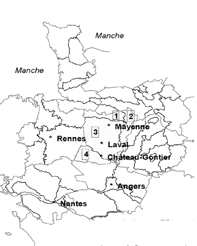
Figure 5. General situation of the Department of
Mayenne. The forest regions:
1. Normandy hills
2. Avaloirs-Coëvrons
3.
Bas-Maine
4. Bocage area of Angers
2 The typology can vary somewhat depending on the data source.
3 Energy equivalent: one stere = 0.147 ton oil equivalent (TOE).
![]()
![]()
![]()