Current harvesting practice in Suriname has considerable potential for improvement both in terms of efficiency of harvesting operations and in terms of environmental impact of logging activities. Whiteman (1999b) identifies skidding and long-distance transport as the two most important aspects of current practices in terms of their impact on production costs. The absence of proper harvest planning in the majority of concessions further contributes a low level of inefficiency and productivity.
Planning of timber harvests is one part of overall forest management planning, which is itself a component of comprehensive land-use planning (Dykstra & Heinrich 1996). To be effective, harvest planning must be based on a general forest inventory for the concession area and a comprehensive pre-harvest survey including terrain reconnaissance of each cutting unit prior to harvesting. This permits the development of accurate plans, which in turn will permit operators to improve operational control, optimise harvesting production rates, and reduce environmental impacts. All planning of harvesting operations should be guided by the consideration that unless the forest is left in a condition that will permit the attainment of a desired future condition, sustainability cannot be assured.
As far as forest inventory requirements are concerned, the Forest Management Act of 1992 (FMA) requires that inventories be conducted on newly granted concessions. However, implementation of FMA has been very limited to date (Eckelmann 1999). Before an application for a new concession can be submitted, FMA requires that an exploration inventory be conducted on the area. This first assessment is meant to serve as a basis for determining the AAC and for subsequent zoning of the concession into operating classes. However, the AAC is more commonly based on the number of years of the concession agreement and local experience from the past.
Mitchell (1998) found that the majority of forest operations in Suriname are managed either by small to medium-sized sawmills or by some of the larger independent logging companies. Most of the concessions operated by these companies were granted before FMA 1992 came into force. The area on these older concessions, many of which are still being operated, averages about 12,000 ha. For a cutting cycle of 25 years, this suggests that on a "typical" forest concession in Suriname, the area logged averages about 480 ha per year.
However, according to Mitchell (1998) it is believed that many concessionaires repeatedly cut over a much smaller area, focusing only on the more accessible portions of their concessions. Discussions with forest managers confirmed that generally only small areas are harvested each year. Mitchell (1998) finally used in his analysis an annual cutting area of only 220 ha per concession. This was the annual area harvested as determined by Hendrison (1990) for a large and relatively well-equipped forest concession in Suriname.
Results from the CELOS experiments suggest that a yield of 20-30 m³/ha on a cutting cycle of 20-25 years may be possible, although this depends in part on the application of silvicultural measures that appear to be completely unapplied in Suriname at present. Mitchell (1998) therefore used in his analysis a harvesting intensity of 17.5 m³/ha based on observations made by Hendrison (1990) regarding the yields that can be expected without silvicultural interventions.
Multiplying this average harvesting intensity by 136 ha, the estimated annual cutting area of Concession 387, suggests that the current level of production in Mr Doerga's concession might be around 2,380 m³/year. Results from the field study, however, suggest that the harvesting intensity may be lower-perhaps only three-quarters of the average level used by Mitchell (see Table 5). The average level of production estimated by Mitchell (1998) of around 3,850 m³/year for a "typical" forest concession in Suriname of about 12,000 ha also suggests that the actual annual level of timber production is probably much lower than the above-mentioned value for Concession 387. According to old LBB records available for the concession, annual production of roundwood averaged only about 1,000 m³ during the period 1978-88. This is probably driven more by markets and operating considerations than by the productivity of the forest, which appears capable of sustaining higher annual levels of harvest.
New concession agreements issued under FMA 1992 not only require forest inventories but also include conservation clauses that prescribe species to be harvested (or protected) and mandate the delineation of conservation zones. Thus the first steps are being taken towards comprehensive forest planning, an essential component of sustainable forest management.
In general, harvest plans are of two types (Dykstra & Heinrich 1996): long-term (strategic) and short-term (tactical), with the latter always to be based on the strategic plan to ensure coherence throughout the whole planning and implementation process.
The strategic harvest plan for an operating area demarcates non-harvest zones such as preservation blocks and non-forest areas; divides the production forest into annual operating areas, often referred to as "coupes"; and shows both the existing and proposed transportation systems. A coupe is not necessarily a single, contiguous block, as areas to be harvested within a given year may be dispersed throughout the concession for various reasons.
The tactical plan provides details of operations that are to be carried out during a period of one year and is therefore associated with the annual coupe. However, at present only one company in Suriname is known to demarcate annual cutting blocks (Eckelmann 1999). It is SBB's policy to define management units of 100-500 ha which will then be divided into 12.5-ha plots, referred to as "cutting units", which are the smallest administrative units. Under favourable terrain conditions where only one harvesting system is used (e.g., ground skidding) and the cutting units are contiguous, planning the layout of landings and skidtrails for all cutting units within a management unit can be done simultaneously.
In order to draw up a tactical plan for selection harvesting in a tropical forest, a pre-harvest inventory, often referred to as stock survey, has to be carried out and each cutting unit must be mapped individually. The boundaries of the cutting unit and all features that may influence harvest planning (water courses, swampy areas, slopes, or other problem sites) should be shown on this map, for which the recommended scale is between 1:1,000 and 1:10,000. Furthermore, the location of each individual tree that might be harvestable is marked on the map (see Figures 3 and 4). In forests with a high density of climbing vines, it is generally recommended that the pre-harvest survey be done well in advance of harvesting and that climber cutting be done at the same time as the trees are being marked for felling. The climbers, which tend to bridge across tree crowns, will then die and become brittle, reducing the chance that a felled tree will pull over neighbouring trees as it falls (Dykstra & Heinrich 1996).
The new concession agreements issued under FMA 1992 require that pre-harvest inventories be conducted, but only one concession holder at present is known to carry out such surveys (Eckelmann 1999). Other licensees only undertake conventional prospecting, often referred to as "tree spotting", which involves identifying potential trees but not mapping their locations.
All information about each harvestable tree that is recorded on inventory sheets in the field should then ideally be entered into a database for the concession. This would facilitate harvest planning by permitting the concession holder to evaluate silvicultural alternatives and use information about market acceptance of various tree species to plan the cut. It would also assist in determining which species are locally rare or regenerate poorly under current harvesting regimes.
All trees to be harvested are to be marked on the tree location map (stock map) for the cutting unit. The spatial distribution of the harvest can then be adjusted as necessary to avoid large canopy openings that would be caused by felling several neighbouring trees. The final map of the cutting unit, which shows terrain features as well the location of harvestable trees, future crop trees, and each tree to be felled, should finally serve as the basis for the layout of skidtrails and landings. The logging supervisor can then use the map, together with field checking, to ensure that the harvesting plan is feasible and that the operation can be undertaken safely, efficiently, and economically.
A copy of the harvest map and accompanying information about the trees to be harvested should be provided to the felling crew. This will reduce or eliminate time spent searching for the trees to be felled (see Section 6.1.1). In order to detect hidden internal decay, an investigative cut with the chainsaw blade should be made into each tree selected when the presence of decay is suspected. This helps avoid unnecessarily felling trees that cannot be utilised, improving felling productivity and reducing needless canopy opening.
All trees cut during felling operations should be marked on the map. Each log cut from the tree should be tagged and recorded in order to ensure that it is not missed by the skidding crew. An updated map of the cutting unit showing the location of the felled trees and the associated log numbers should then be provided to the skidding crew. Actual locations of skidtrails and landings should also be drawn on the map after they have been established in the field. This will facilitate their reuse during future harvest entries.
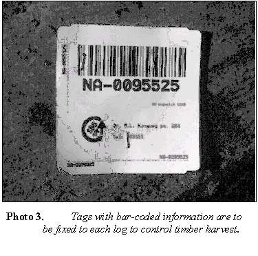
According to a recently introduced system, licensees are required to keep logging registers and fix tags with bar-coded information to each log (Photo 3). Corresponding tags are also to be attached to tree stumps so that each log's origin can be traced if necessary (personal communication with SBB). Log movement by truck is monitored by SBB/LBB during scaling, which occurs during the transit of logs from the forest to the sawmill (Eckelmann 1999).
The concept of opening up forests by a permanent road network, as a precondition for forest management and sustainable utilisation, is widely accepted both to specialists and to the public at large, but it is a difficult concept to put into effect. From the environmental point of view, forest roads are unquestionably the most problematic features of timber harvesting operations. They are complex engineering structures upon which transport efficiency depend and are essential to reliable access to the forest for management and monitoring purposes (Dykstra & Heinrich 1996).
Therefore, comprehensive planning is required for proper location, design, construction, and maintenance of forest roads and subsidiary structures, in order to meet environmental and economic objectives. Another important fact to be considered in road planning activities in remote areas of Suriname is that, as in the case of the Bruynzeel Road, forest roads not only serve timber harvesting purposes but are also an integral part of the local development infrastructure.
The general layout of the forest road network as the basic component of the transport system varies considerably due to many factors such as:
· size of the area to be opened up;
· geological, morphological and hydrological terrain features;
· timber resource and growing stock;
· labour workforce and cost;
· road construction equipment; and
· anticipated harvesting systems.
The planner's main objective is to find a feasible and economical system with the lowest cost in the long run while serving the needs of multiple-use management and environmental protection.
In this context it should be mentioned that some forest concessions in Suriname use barges or pontoons to transport timber. Water transport is often considered much cheaper per kilometre than road transport because large volumes of timber can be transported on each trip. However, the cost of water transport might also be much higher than road transport due to the need to unload and re-load roundwood from trucks onto barges. Whiteman (1999b) found that in Suriname water transport becomes financially more attractive than road transport at distances of around 150 km, depending on the level of forest utilisation.
Independent of any consideration of cost, a combination of road and water log transport is sometimes the only option in Suriname to transport timber to the market due to bottlenecks in the road infrastructure. As one example, all timber from concessions west of the Saramacca River along the Bruynzeel Road in the District of Para must be offloaded from trucks onto barges for subsequent transport by water because of a bridge that is impassable by heavy timber trucks.
For opening up the annual compartments in the most efficient way, the following should be kept in mind:
· forest roads are constructed where access to individual compartments is required but the transportation system as a whole should be designed for the entire concession area;
· road density for ground-skidding operations is planned for an average skidding distance of 500-600 m and a maximum skidding distance of 800 m;
· the total length of roads and skidtrails should be minimised to keep costs of construction and maintenance low and to reduce environmental impacts;
· difficult terrain and streams, and problem areas such as swamps, should be avoided to minimise environmental problems;
· year-round access must be provided where forest roads are part of the local infrastructure;
· the planned driving speed for loaded logging trucks should be about 40 km/h;
· a storage capacity of at least 800 m³ is needed on each landing that serves several cutting units, taking into account the current level of harvesting intensity and the fact that cutting units are planned for a size of 12.5 ha.
Following these general considerations, the planning forest engineer at a forest estate in the Brazilian Amazon, where terrain and forest conditions are generally similar to those in Concession 387 and the Kabo area as a whole, developed the following standards for road and skidtrail densities (Winkler 1997):
· Forest roads 8-9 m/ha (· average spacing between roads of 1,100-1,250 m)
· Skidtrails 120 m/ha (· average spacing between skidtrail of 83 m)
Due to the favourable terrain conditions on the Brazilian estate, the generally recommended straight alignment of skidtrails (see Dykstra & Heinrich 1996) was followed wherever site conditions permitted, in order to keep the total length of skidtrails to the absolute minimum. The distance between adjacent skidtrails was planned at 100 m, yielding a maximum winching distance during extraction of 50 m (Winkler 1997). Landings were established about 500 m apart on both sides of the forest roads with each 40 m x 40 m landing intended to serve as a collection point for timber from four cutting units.
Whiteman (1999b) assumed an existing road density of 5 m/ha in forest concessions in Suriname. As regards the proper drainage of forest roads in this region of high precipitation, no special rules for establishing culverts seem necessary due to the generally favourable terrain conditions for forest road construction. Determination of proper size and spacing of culverts is to be decided for each site individually according to terrain condition and runoff rates expected.
In recent years there have been few road-building activities in the concession areas of the District of Para. Concessionaires rely almost completely on the Bruynzeel Road, for access to their concession areas. Proper maintenance of the Bruynzeel Road is thus essential to ensure that access to the forest is available when needed. Road maintenance is done either with machinery of the Bruynzeel company or with machines hired from a local construction company. Re-shaping and re-surfacing of the road is done with motor graders. However, as in other wet tropical areas, lack of gravel means the road is largely unavailable for use during rainy periods. The cost of maintenance is shared among the concessionaires and other users of the road.
A construction site in a concession in the District of Brokopondo, neighbouring on the south-eastern edge of Para, shows that road construction operations basically do not differ from elsewhere in primary tropical rain forests, with such projects involving clearing vegetation and moving soil in order to create structures capable of supporting heavy vehicles. However, the very large trees common in some parts of the tropics occur only very infrequently in Suriname's rainforests.
When required, the machinery used in road construction is normally hired by concessionaires from construction companies. Typically this would be either a Caterpillar D6 or D8 bulldozer, the latter providing higher performance but at considerably higher cost.
As mentioned in Section 3.1, new concession agreements issued under FMA 1992 include a requirement that pre-harvest inventories be conducted. Although not yet implemented at the time of the study reported here, this requirement will include a 100% stocking survey to develop tree location maps at a scale of 1:1,000. Eventually this will be obligatory before a concession license can be issued (personal communication with SBB).
After having demarcated areas where timber harvesting is to be prohibited or restricted due to the general concept of the sustainable management plan, a regular grid (north-south/east-west) must be laid out over the entire concession area. The grid will permit all administrative units, coupes, and cutting units to be conveniently referenced on the ground.
Each block as defined by the grid system will then be subdivided into cutting units. According to Eckelmann (1999), cutting units of 12.5 ha in size are envisaged. However, experience in the field will show the most appropriate size. In smaller concessions, the survey crew will probably only open and mark the borderlines of individual cutting units. On larger concessions a proper permanent grid for the whole concession area is to be opened, with all main gridlines permanently marked and kept open by clearance of undergrowth when necessary. On both large and small concessions, temporary grids of 50 m x 50 m or 50 m x 100 m will be established within each cutting unit in order to facilitate the work of the inventory crews.
In this study a commercial forest inventory, which normally should be conducted during the dry season two years before harvesting, was carried out by staff of SBB for the two sample units, Plot/01 and Plot/02, just before harvesting commenced. The inventory crew used for the survey was considered representative in terms of the number and level of education of crew members for current and future stocking surveys in Suriname's forests. The inventory crew consisted of five persons, a crew leader (forester) and four assistants (tree identifiers).
During the survey, the crew members moved parallel to one another through the rows of the cutting unit formed by the 50 m x 100 m grid system, searching for trees of commercial interest with dbh > 40 cm and Bruinhart trees with dbh > 25 cm. To obtain information on potential crop trees in the study area the inventory crew also searched for trees of commercial interest with dbh between 25 and 40 cm on Plot/01, and of principle tree species between these diameter limits on Plot/02.
Each tree found was marked and the following parameters were assessed in the field and recorded by the crew leader on data sheets:
· tree location and tree number
· botanical identification of tree species
· girth or diameter at dbh
· quality features and visible defects
· other pertinent information
In addition, the following information was recorded in order to provide reliable information for comprehensive planning of harvesting operations:
· the location and size of any utilisable dead trees
· topographic features that may influence harvest planning
Other tasks normally performed by the inventory crew include the following:
· drawing a map showing tree locations and topographic features
· cutting climbers attached to trees selected for felling or to their immediate neighbours
As already mentioned in Section 3.1, in forests where climbers that interconnect tree crowns are frequent, it is recommended that the climbers be cut well in advance of the felling operation (Dykstra & Heinrich 1996). In order to avoid the need of revisiting the area before felling, climber cutting is normally done by the inventory crew at the same time as harvestable trees are registered.
Based on field work at the study site, the following performance can be expected in field surveying and tree mapping of individual cutting units with an inventory crew as outlined above:
Sample unit |
Types of trees located and measured |
Production rate | ||
Plot/01 |
commercial species with dbh > 40 cm and |
2.5 person-days/ha | ||
commercial species with dbh 25-40 cm |
||||
Plot/02 |
principal tree species with dbh > 40 cm and |
1.5 person-days/ha | ||
principal tree species with dbh 25-40 cm |
Individual field activities undertaken by the survey crew included line cutting to establish the border of the sample unit (250 m x 400 m), line cutting to establish the temporary grid of 50 m x 100 m rectangles, and conducting the actual inventory, including mapping. Limiting the inventory to just the principal tree species in Plot/02 significantly increased the production rate of the crew. However, a crew involved in inventory field work throughout the season might achieve considerable higher production rates. For a similar type of inventory in Brazil, a production rate of about one person-day/ha was obtained under similar terrain and timber conditions (Winkler 1997).
Felling, one of the most hazardous of occupations, is in Suriname generally carried out by poorly equipped and untrained workers who are frequently hired by a concessionaire only for a single job on a piece-rate basis.
The felling crew usually consists of one chainsaw operator and one assistant, often using the concessionaire's felling equipment. Many chainsaw operators start out as assistants and learn to cut timber by working with a more senior person whose own knowledge of felling and cutting techniques as well as chainsaw maintenance may be very limited. Lack of training in proper felling techniques, of supporting tools such as wedges and axes, and of helmets and other safety equipment make felling operations both difficult and hazardous. The crew and equipment actually observed in this study were as follows:
Felling crew |
Equipment used | |
1 chainsaw operator |
1 Stihl AV 070 chainsaw | |
1 assistant |
1 maintenance toolkit | |
1 machete |
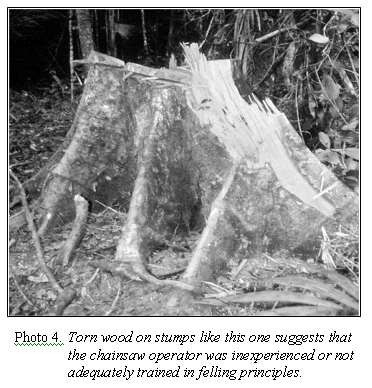
The intended felling direction of each tree is decided by the chainsaw operator based on his judgement of how the tree can be felled safely without becoming hung up in the crowns of neighbouring trees. However, misjudgement and poor understanding of felling principles frequently result in unnecessary breakage (Photo 4), damage to residual trees, and personal danger to the felling crew. On this study, a poorly maintained chainsaw frequently broke down at critical points during felling.
In order to achieve felling operations that meet ergonomic, economic, and environmental objectives, the following measures should be considered:
Objectives |
Recommended measures |
Achieve a high standard of felling safety |
· hire personnel fully qualified for the work task, in good health, able to recognise hazardous situations, and with personal responsibility · provide appropriate safety gear and properly maintained equipment · provide training in proper felling techniques · provide training in maintenance of equipment · require climber cutting prior to harvesting · supervise operations closely |
Minimise damage to residual trees and stand |
· require directional felling · require climber cutting sufficiently in advance of harvesting (perhaps 6-18 months) to ensure that the vines become brittle and break easily · ensure that a tree location map is provided to the felling crew |
Maximise volume of wood utilised from each felled tree |
· ensure the use of proper felling and crosscutting techniques · require climber cutting sufficiently in advance of harvesting · ensure that operators follow bucking and grading rules · supervise operations closely |
Facilitate efficient extraction |
· provide a tree location map to the felling crew that shows skidtrails · require the use of directional felling · supervise operations closely |

Photo 5. Filing the cutting chain, using techniques that violate all safety instructions in the chainsaw manual.
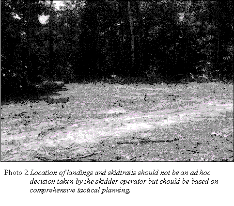
The skidding operation is normally planned to begin several days after completion of felling operations. However, due to the time constraints in carrying out this study, extraction of logs started immediately after the felling crew had left sample unit Plot/01 to commence felling on Plot/02. Starting from the existing forest road, the skidder operator opened a short road up to 8 m in width to provide access to the harvest area. Clearing vegetation and moving soil was done by means of the skidder's blade. At the end of this short access road, a landing was established on both sides of the road to serve as a collection point for logs extracted from the sample units.
On Plot/01, skidding was done in the conventional way. Having established the landing, the skidder operator got off the skidder and walked the area in the vicinity of the landing, searching for logs in order to decide how to arrange the work. The skidder operator then drove the skidder into the stand in the general direction of the felled trees.
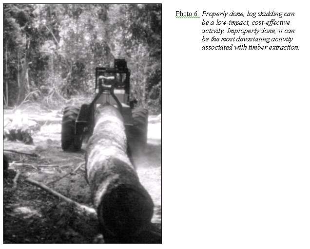
In the conventional logging system, the skidder operator drives to each felled tree. The winch line is then wrapped directly around the log to be skidded. To enable the skidding assistant to push the winch line under the log, the skidder operator often uses the skidder's blade to raise the log by pushing it against nearby trees. As a consequence, the neighbouring trees are often bent or broken, or their bark is stripped off. In some cases, more than one log may be skidded at a time. To accomplish this, the logs are manoeuvred into alignment by the skidder, an activity that may cause extensive soil disturbance and damage to residual vegetation in the vicinity of the felled tree. This could be avoided by attaching a choker cable to each log and then gathering the choker cables with the winch line, a technique that is commonly used in industrialized countries.
Another procedure that was observed on the study area to have a significant negative impact on the residual stand is the fact the skidder operator often followed a different route to the landing than the one followed to reach the felled tree. This practice results in substantially more soil disturbance and damage to residual vegetation than if designated skidtrails were used. In addition, the skidder operator sometimes searched for felled trees by driving the skidder through the forest, rather than by walking. In the aggregate, these unplanned searching and skidding activities contributed to a dense criss-crossing network of skidtrails, some of which even led to natural canopy gaps in which no tree was felled.
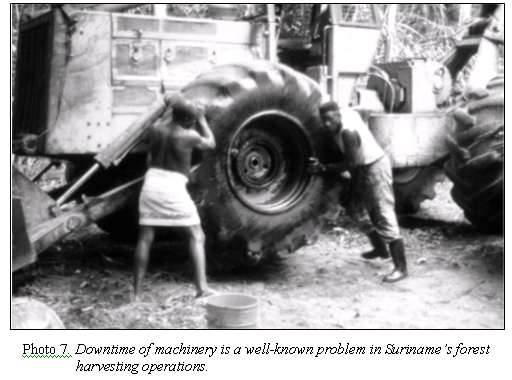
On both sample plots, extraction was carried out by means of wheeled skidders. After about two-thirds of the logs had been extracted from Plot/01, the Caterpillar skidder being used on that study plot broke down and replacement parts had to be ordered from abroad. Skidding was therefore shifted to a smaller Franklin skidder that was available nearby. This necessitated a change in the skidding crew as well. Details of the skidding crews and equipment used during the study are as follows:
Study Plot |
Skidder |
Skidding Crew |
Plot/01 First 2/3 of area |
Caterpillar 528C wheeled skidder with winch |
1 skidder operator (Crew A) 1 assistant (Crew A) |
Final 1/3 of area Plot/02 |
Franklin 170 wheeled skidder with winch |
1 skidder operator (Crew B) 1 assistant (Crew B) |
In contrast to the conventional skidding system used in Plot/01, skidding on Plot/02 was carried out in the manner of planned harvesting supported by use of the tree location map that had been prepared during the pre-harvest survey. All trees felled in Plot/02 were marked on the map, including their approximate direction of fall. Using this information, a skidtrail system was designed and drawn on the map, utilising old skidtrails where appropriate.
After receiving instructions from the person carrying out the work and time studies, the skidder operator moved from the landing into the stand, opening the designated and pre-marked skidtrails and using the skidder's blade as needed to clear obstacles. Logs lying across the skidtrail were skidded to the landing before opening of the trails continued.
Turning at the end of the opened skidtrail, the skidder moved to the first stop for attaching logs as determined by the assistant. The assistant's decision was based on the tree location map and an inspection of the field situation, considering the location of future crop trees, regeneration, understory vegetation, and obstacles.
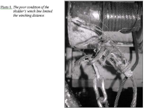
The planned procedure was for the assistant to pull the winch line to the log and attach it while the wheeled skidder remained on the designated skidtrail. The log would then be winched to the skidder. Normally, in easy terrain where the recommendation of straight alignment of skidtrails is followed, the distance between adjacent skidtrails would be planned at 100 m and the winching distance would be a maximum of 50 m. A chainsaw would be available to crosscut logs too heavy to be winched, to trim branches from improperly topped trees, or to remove smaller trees from the cableway when necessary. However, due to the unplanned use of the Franklin skidder, which was equipped with a badly frayed winch line so that only a short section could be used, the planned extraction procedure had to be altered. Instead, the skidder operator reversed the skidder to the felled tree along the planned cableway. Only the final eight trees could be skidded in the planned way, due to the arrival of a new winch line for the skidder.
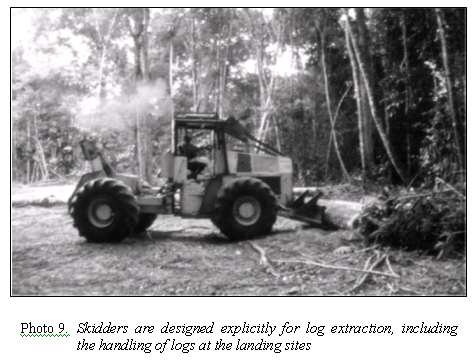
Landings are collection areas to which logs are delivered during the extraction process and represent the interface between extraction and transport of logs (Dykstra & Heinrich 1996). The location and design of landings should be done during harvest planning, at the same time that the forest roads are located and designed. At the landing the logs may be sorted, possibly stored temporarily, and then assembled for transport to the processing facility or other final destination. Temporary storage of logs should be considered in case of:
· frequently occurring delays in extraction which do not allow for loading activities to be carried out simultaneously with extraction;
· the need for a timber "buffer" in order to ensure continuous timber supply either to a company-owned sawmill or to fulfil contractual obligations;
· a significant benefit would be achieved through loss of log weight during storage (e.g., due to the capacity of the transport equipment to be used);
· bucking (crosscutting into logs) is to be done at the landing and the logs separated according to tree species or utilisation groups.
However, storage time of logs in the forest is limited many species risk deterioration in quality due to insect or fungal attack. The maximum storage time for softwood species is normally about one month, and for most hardwood species about two months might be planned. Due to different storage times they should be stored in separate log decks. The log loading at the landing is carried out by means of a company-owned front-end loader; the transport of logs to the riverside by means of the company-owned truck.
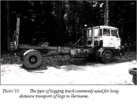
The log transport from the forest of Concession 387 to the Saramacca River is carried out with the company-owned logging truck (Photo 10). The only transport infrastructure used is the Bruynzeel Road. Since no long-distance transportation occurred from the study area during the time of the case study, it was not possible to observe log hauling from the landing to the river However, discussions with the concessionaire and workers indicate that up to about 20 mB3 of roundwood are transported each trip depending on the different species' weight. This information is consistent with findings by Whiteman (1999b), who indicated that the typical forest operation in Suriname uses trucks, often home-made, with a carrying capacity of about 20 m3.