

Annexe 4. Field excursion
(Excursion sur le terrain) 12 - 13 October 2000
M. Igue. R. Sant'Anna and J. Diels
Time schedule
Geology and geomorphology
Overview of
landscapes and soils
Soil profile descriptions and analysis
12/10/2000
7.30: |
Introduction to the biophysical environment of south-central Benin (Geology. Geomorphology. Climate and Soils ) |
7.45: |
Departure to Aplahoué and Eglimè (150 km. Mono Department) |
8.45: |
Toposequence 3 with profiles 9 to 11 on gneiss and migmatite (BJ EGLI 7. BJ EGLI8 and BJ EGLI 9) |
10.10: |
Toposequence 1 with profiles 1 to 3 on Continental Terminal (BJZOUZ1. BJZOUZ3 and BJZOUZ4) |
13.10: |
Lunch |
14.10: |
Toposequence 2 with profiles 4 to 8 on gneiss and migmatite (BJEGLI1. BJEGLI2. BJEGLI3. BJEGLI4. BJEGLI5) |
17.30: |
Departure to Abomey (60 km. Zou Department) |
18.15: |
Arrival and night at Abomey |
13/10/2000
7.45: |
Departure to Dassa-Zoumé (80 km) |
9.00: |
Toposequence 4 with profiles 12 to 14 on colluvium. gneiss and migmatite: (BJIGM1. BJIGM2. BJIGM3) |
11.00: |
Toposequence 5 with profiles 16 to 18 on basalt (BJIGM5. BJ CS 6 and BJ CS 7). |
13.00: |
Lunch |
Benin is situated on the Precambrian crystalline rocks. usually known as "Basement complex"; petrographically. it is largely composed of acid metamorphic rocks of the Dahomeyen series (gneiss. migmatite. granite). Included are basalt. gabbro. quartzite and volcano-sedimentary intrusive mylonite as well as rhyolite.
Migmatites cover more than 60 percent of the study area. They show a great variety of morphology. In this unit are grouped gneiss with biotite and amphibole. amphibolite and gneiss which are characterized by intensive migmatisation.
The South is covered by sediments of Cretacean to Quarternary ages.
The particular geomorphology of great zones is closely linked to lithology and geological history. The landscape is characterized by peneplains with scattered inselbergs. plateaux and the valleys of three rivers. The southern border is formed by the Cretacean plateau.
This peneplain is crossed in the South-East by the Couffo river. in the West by the Ouémé which receives important affluents as the Okpara from North-East and the Zou from North-West. It is dominated by a string of mountains. These form units which are positioned NS: Dassa. Gobada. Logozohe. Tchetti. Savalou. Lanta. and Badagda. The study area is overlooked by Dassa and Savalou mountains (mean altitude 400 m. higher elevations are up to 465 m).
The peneplains seem to correspond with an old levelling surface or old pediment and the mean altitude is about 200 m. It stretches from a piedmont with gentle slope hills to rivers. But the slope from the Cretacean plateau to the crystalline basement is very abrupt. The plateau distinctly overlooks the peneplain by more than 50 m (100 m in some places). Some relics and some outcrops of ferrugineous crusts indicate this old surface in the Savalou zone. With the incision of the actual hydrographic network this old surface is mainly eroded. The hydrographic network follows the geological formations.
In the West of the study area. the topography is very gentle. The basement outcrops are very frequent but inselbergs are rare.
In the East. the landscape is formed by hills and the hydraulic network is dense.
In the South. the landscape forms a more pronounced topography with short rectilinear glacis. This zone corresponds with the younger part of the Crystalline basement.
Generally. the peneplain can be considered as surrounded by two higher altitude levels: Sedimentary plateau series in the South with more than 200 m and limited by a ledge ; Mountain range of Savalou in the North.
The peneplain is composed of two levels: (1) medium level altitude (120-200 m) with very few marked landforms and convex slopes flank the granitic zones and short concave slopes elsewhere. In this way. the landform consists of small domes (interfluves) with 2-3 percent slope where rill erosion is intensive and gully erosion starts from minor bed of backwaters. (2) low level altitude (< 120 m) with less than 1 percent slope.
On the plateau the major soils are Ferrali-haplic Lixisols (60 percent) and Ferrali-haplic Acrisols (40 percent) with medium pH (» 6.0). low CEC (7.0. apparent CEC 19.8 for Bt horizons) and base saturation of about 60 percent (Bt horizons). On gravelly escarpments Leptosols and further downslope colluvial Arenosols occur. Valleys on Continental Terminal are dominated by Fluvisols and Gleysols.
The distribution and variability of soil types within terrain components can be derived from transects. Accordingly. most soils of the high peneplain on gneiss. migmatite. rhyolite and sandstones basement are Ferric Luvisols with a CEC of more than 24 meq/kg clay. Haplic Acrisols. Ferric Alisols and Ferric Lixisols are also found. sometimes associated with Haplic Arenosols on the transect. The B horizons of these ferric soils have a high content of Fe-Mn concretions. quartz gravel and stone fragments which are sometimes baked into ironstone. Plinthosols are also common in the sequence.
Removal of surface materials due to erosion forms skeletic or petroplinthic phases. which encourage water stagnation (Stagnic Luvisols) in the lower slopes of the transects.
When the soils are formed from granitic and quartzitic basements. the major soils are Haplic Arenosols with Eutric Regosols associated. These soils occupy great areas in the Agouna. Paouignan and Savè zones.
In the low peneplain the major soils are Mollic Gleysols. Eutric Vertisols. Eutric Cambisols and Mollic or Stagnic Solonetz. These soils. which are developed on basic rocks. have a high clay content and CEC. often with iron concretions. Organic matter occurs down to 0.5 - 0.6 m. Mollic Fluvisols sometimes occupy shallow valleys along rivers and streams.
Iron nodules and concretions are formed in the kaolinitic as well as in non kaolinitic matrix. But normally they are residually concentrated in the stoneline that is emplaced during slope evolution. Two types of nodules co-exist in the soils: pisolithic concretions on the one hand and lateritic materials and the nodules which must be considered as relics of an ancient weathered lateritic mantle on the other. The latter provides evidence of a former large extension of this mantle over the basement. The mantle seems to have been irregularly removed by drainage rejuvenation.
Relief seem to be an important factor of soil formation at the flanks of inselbergs where Mollic Leptosols are associated with Umbric Cambisols.
ZOUZ 1
Soil Classification:
WRB: Eutri-Ferralic Nitisol (Chromic Lixisol ?)
Soil Taxonomy (1998): Fine-clayey Isohyperthermic Typic Kandiustalf
CPCS (1967): Sol ferralitique faiblement désaturé
Authors: E. Mathé and A.M. Igué (4/5/98)
Location:
Vodjihoué village (Zouzouvou). Département du Mono. Benin
6o 54.041' N. 1o 41.560' E; Elevation: 160 m
Land system:
Parent material: Sandy clay of Continental Terminal formation
Physiography: Dissected plateau (Plateau d' Adja) with steepest slopes between 2 and 8 percent
Position in land system: The site is located on the plateau on a 500 m long gentle linear slope (0.5 percent)
Vegetation: maize. oil palm and Eucalyptus trees (reforestation)
Climate: Subhumid Tropical with bimodal rainfall (1084 mm per annum) and average temperature 27.3 °C
Moisture regime:
Moisture condition at the time of examination: moist
Depth of groundwater level: >2 m
Drainage: well drained
Internal drainage: rapid
Runoff: slow to very slow
Surface features:
Presence of surface stones or rock outcrops: none
Water erosion: sheet erosion. class 1
Other features:
Root distribution: up to 60 cm
Effective soil depth: 120 cm
Soil fauna: krotovines. insect nests
Surface sealing and crusting: none
Surface cracking: none
Brief soil description:
Deep. dark reddish brown to red sandy loam on sandy clay soil with moderately developed subangular polyedric structure. showing many pores and well developed rooting pattern
Detailed soil description
Ap 0-14 cm |
Dark reddish brown (5 YR 3/3) when moist. loamy sand; friable when moist; weakly developed very fine granular structure; many fine vesicular and interstitial pores; many fine roots; clear smooth boundary. |
E 14-40 cm |
Dull reddish brown (2.5 YR 4/4) when moist. sandy loam; friable when moist; weakly developed fine and medium subangular blocky structure; many fine vesicular. interstitial and tubular pores; many fine and medium roots; gradual smooth boundary. |
Bt1 40-62 cm |
Reddish brown (2.5 YR 4/6) when moist. sandy clay loam; friable to firm when moist; moderately developed medium to coarse subangular blocky structure; many fine to medium vesicular and tubular pores; continuous clay and Fe/Al cutans on root channels; common fine and medium roots; clear smooth boundary. |
Bt2 62->120cm |
Red (10 R 4/6) when moist. sandy clay; strongly developed medium to coarse subangular blocky structure; many fine and medium vesicular and tubular pores; continuous clay and Fe/Al cutans on root channels; few fine and medium roots. |
ZOUZ 3
Soil Classification:
WRB: Epipetric Plinthosol
Soil Taxonomy (1998): Fragmental Isohyperthermic Lithic Ustorthent
Authors: E. Mathé and A.M. Igué (6/5/98)
Location:
West of Vonnouhoue Village (Zouzouvou) in area with ironstone outcrops. Département du Mono. Benin
6o 54.420' N. 1o 40.332' E; Elevation: 120 m
Land system:
Parent material: Sandstone of Continental Terminal formation
Physiography: Dissected plateau (Plateau d' Adja) with steepest slopes between 2 and 8 percent
Position in land system: The profile is located just below a scarp on the upper valley side on a 200 m long convex slope (12 percent).
Vegetation: maize. oil palm
Climate: Subhumid Tropical with bimodal rainfall (1084 mm per annum) and average temperature 27.3 °C
Moisture regime:
Moisture condition at the time of examination: moist
Depth of groundwater level: >2 m
Drainage: moderately well drained
Internal drainage: rapid
Runoff: medium
Surface features:
Between 15 and 90 percent of surface is covered with stones; stones are 0.75 to 1.6 m apart; no rock outcrops
Water erosion: sheet and rill erosion. class 2
Other features:
Root distribution: up to 100 cm
Effective soil depth: >100 cm
Surface crusting: present
Surface cracking: none
Brief soil description:
Shallow red loamy sand on sandy clay loam. with many petroferric sandstone gravels. stones and boulders. structureless. porous and with well developed rooting pattern
Detailed soil description
AP 0-10 cm |
Dark reddish brown (5 YR 3/3) when moist. gravelly loamy sand; loose when moist; weakly developed fine granular structure; many fine and medium vesicular and interstitial pores; 40 percent 5-10 mm irregular red hard Fe-Mn nodules; common very fine and fine roots; clear smooth boundary. |
ABsm 10-27 cm |
Dark reddish brown (5 YR 3/4) when moist. very stony loamy sand; friable when moist; no structure; many medium interstitial pores; 30 percent 5-10 mm irregular red-black hard Fe - Mn nodules; 60 percent 50-150 mm angular red-black Fe/Mn/kaolinite stones; common very fine and fine roots; clear wavy boundary. |
Bsm1 27-70 cm |
Dark reddish brown (2.5 YR 3/6) when moist. very bouldery sandy loam; friable when moist; no structure; many fine interstitial pores; 30 percent 5-10 mm irregular red/black hard Fe/Mn nodules; 60 percent 50-300 mm angular red/black/yellow hard Fe/Mn/kaolinite stones; common very fine. fine and medium roots; gradual wavy boundary. |
Bsm2 70->100 cm |
Reddish brown (2.5 YR 4/6) when moist. very bouldery sandy clay loam; friable when moist; no structure; many interstitial pores; 30 percent 5-10 mm irregular red/black hard Fe/Mn nodules; 50 percent 300 mm angular red/yellow hard Fe/kaolinite stones; common fine and medium roots. |
Soil analysis of profile 2
ZOUZ 4
Soil Classification:
WRB: Eutric Regosol ?
Soil Taxonomy (1998): Fine-loamy Isohyperthermic Typic Ustorthent
CPCS (1967): Sol ferrallitique faiblement désaturé
Authors: A.M. Igué and E. Mathé (4/5/98)
Location:
West of Vonnouhoué village (Zouzouvou) near stream. Département du Mono. Benin
6o 54.560' N. 1o 40.247' E; Elevation: 100 m
Land system:
Parent material: Colluvial material derived from sandstone of Continental Terminal formation
Physiography: Dissected plateau (Plateau d' Adja) with steepest slopes between 2 and 8 percent
Position in land system: the site is located on the lower valley side (near stream) on a 150 m long concave slope (3 percent).
Vegetation: Maize. cassava. oil palm
Climate: Subhumid Tropical with bimodal rainfall (1084 mm per annum) and average temperature 27.3 °C
Moisture regime:
Moisture condition at the time of examination: moist
Depth of groundwater level: >2 m
Drainage: well drained
Internal drainage: rapid
Runoff: medium
Surface features:
Presence of surface stones or rock outcrops: none
Water erosion: sheet and rill erosion. class 1 and 2
Other features:
Root distribution: up to 90 cm
Effective soil depth: >120 cm
Human influence: pottery fragments
Soil fauna: krotovines. insect nests
Surface sealing and crusting: none
Surface cracking: none
Brief soil description:
Deep. dark reddish brown sandy loam on gravelly sandy clay loam soil. with moderately developed structure. showing few greyish mottles below 90 cm. many pores and well developed rooting pattern. A stoneline at 50 cm depth separates older from more recent alluvial deposits
Detailed soil description
Ap 0-10 cm |
Brownish black to dark reddish brown (5 YR 2.5/2) loamy sand; friable moist; weak fine to medium subangular blocky structure; many fine and medium vesicular and tubular pores; few fine roots; clear smooth boundary. |
C1 (B1) 10-40 cm |
Dark reddish brown (2.5 YR 3/6); sandy loam; friable when moist; moderate medium to coarse subangular blocky structure; many fine and medium vesicular and tubular pores; common fine and medium roots; clear wavy boundary. |
C2 (B2) 40-90 cm |
Dark reddish brown (2.5 YR 3/6); slightly gravelly sandy clay loam; firm when moist; strong medium to coarse subangular blocky structure; many fine and medium vesicular and tubular pores; continuous thin clay/organic matter cutans on root channels; 5 percent 5-10 mm irregular red/black hard Fe/Mn nodules; common fine and medium roots; gradual smooth boundary. |
C3 90->125 cm |
Dark reddish brown (2.5 YR 3/6); gravelly sandy clay loam; few fine distinct clear greyish yellow brown mottles; friable when moist; moderately developed medium subangular blocky structure; many fine and medium vesicular. interstitial and tubular pores; 30 percent 5-15 mm irregular red/black hard Fe/Mn nodules; few very fine and fine roots. |
Soil analysis of profile 3
EGLI 1
Soil Classification:
WRB: Endoskeleti-Endoleptic Cambisol (Eutric) ?
Soil Taxonomy (1998): Loamy-skeletal Isohyperthermic Typic Ustropept
Authors: A.M. Igué and E. Mathé (21/4/98)
Location:
Eglimé village (toposequence 1). Département du Mono. Benin .
7o 4.078' N. 1o 39.512' E; Elevation: 200 m
Land system:
Parent material: Gneiss (Basement Complex)
Physiography: undulating plateau (steepest slopes between 2 and 8 percent)
Position in land system: the site is located on the interfluve crest on a 150 m long linear slope (4 percent).
Vegetation: maize. cassava. oil palm
Climate: Subhumid Tropical with bimodal rainfall (1084 mm per annum) and average temperature 27.3 °C
Moisture regime:
Moisture condition at the time of examination: moist
Depth of groundwater level: >2 m
Drainage: moderately well drained
Internal drainage: rapid
Runoff: slow
Surface features:
Presence of surface stones or rock outcrops: between 2 and 10 percent of area covered with rock outcrops (between 35 and 100 m apart); between 0.1 and 3 percent of area covered with surface stones (between 0.75 and 1.6 m apart)
Water erosion: sheet erosion. class 2
Other features:
Root distribution: up to 75 cm
Effective soil depth: 90 cm
Human influence: cultivation
Soil fauna: insect nests
Surface sealing and crusting: none
Surface cracking: none
Brief soil description:
30 cm thick humus-rich sandy loam to sandy clay loam horizon on very gravelly sandy loam to loamy sand over continuous rock at 90 cm.
Detailed soil description
Ap 0-18 cm |
Black (10 YR 2/1) moist. slightly gravelly sandy loam to sandy clay loam; very friable; moderate medium subangular blocky; many fine vesicular and tubular pores; 5 percent 5-10 mm angular red/black hard Fe/Mn nodules; many very fine. fine and medium roots; clear wavy boundary. |
AB 18-27 cm |
Brownish black (10 YR 3/2) moist. gravelly sandy loam to sandy clay loam; very friable; moderate medium subangular blocky; many fine and medium vesicular and interstitial pores; 15 percent 5-10 mm angular red-black hard Fe/Mn nodules; 15 percent 10-60 mm angular white-yellow hard quartz gravels; many very fine. fine and medium roots; clear wavy boundary. |
Bw 27-46 cm |
Dull yellowish brown (10 YR 4/3) moist. very gravelly sandy loam; soft; weak fine to medium subangular blocky structure; many fine. medium and coarse vesicular and interstitial pores; 60 percent 10-60 mm angular white-yellow hard quartz gravels; few very fine and fine roots; gradual wavy boundary. |
C 46-93 cm |
Brown (10 YR 4/6) moist; very gravelly loamy sand; soft when dry; no structure; many medium and coarse vesicular. interstitial and tubular pores; 80 percent 10-60 mm angular white-yellow hard quartz gravels; few very fine and fine roots. |
R >93 cm |
Rock. |
Soil analysis of profile 4
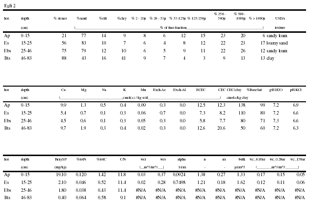
EGLI 2
Soil Classification:
WRB: Episkeleti-Endoleptic Luvisol
Soil Taxonomy (1998): Clayey-skeletal Isohyperthermic Oxyaquic Paleustalf
Authors: E. Mathé and A.M. Igué (21/4/98)
Location:
Eglimé village (toposequence 1). Département du Mono. Benin
7o 4.0455' N. 1o 39.6264' E; Elevation: 190 m
Land system:
Parent material: Gneiss (Basement Complex)
Physiography: Undulating peneplain (steepest slopes between 2 and 8 percent)
Position in land system: the site is located on the upper valley side on a 300 m long linear slope (5 percent).
Vegetation: maize. cowpea. cassava. oil palm
Climate: Subhumid Tropical with bimodal rainfall (1084 mm per annum) and average temperature 27.3 °C
Moisture regime:
Moisture condition at the time of examination: moist
Depth of groundwater level: >2 m
Drainage: moderately well drained
Internal drainage: medium
Runoff: medium
Surface features:
Presence of surface stones or rock outcrops: less than 2 percent of area covered with rock outcrops (> 100 m apart); less than 0.1 percent of area covered with surface stones
Water erosion: sheet erosion. class 2
Other features:
Root distribution: up to 80 cm
Effective soil depth: 100 cm
Human influence: cultivation
Soil fauna: termite burrows
Surface sealing and crusting: none
Surface cracking: none
Brief soil description:
Reddish brown gravelly loamy sand to sandy clay with weak structure and medium drainage
Detailed soil description
Ap 0-15 cm |
Brownish black (10 YR 3/2) moist; slightly gravelly loamy sand; very friable; moderate fine to medium subangular blocky; many fine and medium vesicular. interstitial and tubular pores; 2 percent 2-10 mm angular red-black hard Fe/Mn nodules; 3 percent 5-10 mm angular white-yellow hard quartz gravels; many fine and coarse roots; abrupt smooth boundary. |
Es 15-25 cm |
Greyish yellow brown (10 YR 4/3) moist; gravelly loamy sand; very friable; weak fine subangular blocky; many fine and medium interstitial and tubular pores; 40 percent 2-10 mm angular red-black hard Fe/Mn nodules; 10 percent 5-20 mm angular yellow hard quartz gravels; common fine and coarse roots; clear smooth boundary. |
EBs 25-46 cm |
Brown (10 YR 4/4) moist; very gravelly sandy loam; friable; no structure; common fine and medium vesicular and interstitial pores; 50 percent 2-10 mm angular red-black hard Fe/Mn nodules; 20 percent 5-20 mm angular yellow hard quartz gravels; common fine and coarse roots; gradual smooth boundary. |
Bts 46-83 cm |
Reddish brown (2.5 YR 4/6) moist; very gravelly sandy clay; soft; no structure; weak cementation; common fine and medium vesicular and tubular pores; 50 percent 5-10 mm angular red-black hard Fe/Mn nodules; 30 percent 10-50 mm angular yellow hard quartz gravels; few very fine and fine roots. |
Soil analysis of profile 5
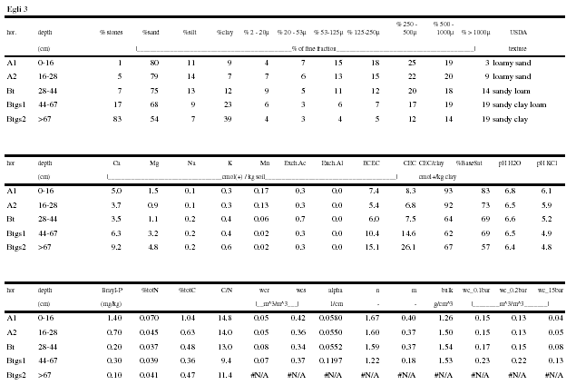
EGLI 3
Soil Classification:
WRB: Stagni-Endogleyic Luvisol (Ferric. Endoleptic)
Soil Taxonomy (1998): Loamy Isohyperthermic Oxyaquic Haplustalf
Authors: A.M. Igué and E. Mathé (23/4/98)
Location:
Eglimé village (toposequence 1). Département du Mono. Benin
7o 4.0570' N. 1o 39.7680' E; Elevation: 185 m
Land system:
Parent material: Gneiss (Basement Complex)
Physiography: Undulating peneplain (steepest slopes between 2 and 8 percent)
Position in landscape: the site is located on the upper valley side on a 300 m long linear slope (4 percent)
Vegetation: cowpea. oil palm
Climate: Subhumid Tropical with bimodal rainfall (1084 mm per annum) and average temperature 27.3 °C
Moisture regime:
Moisture condition at the time of examination: moist
Depth of groundwater level: >2 m
Drainage: moderately well drained
Internal drainage: medium
Runoff: slow
Surface features:
Presence of surface stones or rock outcrops: none
Water erosion: sheet erosion. class 1
Other features:
Root distribution: up to 57 cm
Effective soil depth: 70 cm
Human influence: cultivation (ridges)
Soil fauna: termite burrows
Surface sealing and crusting: none
Surface cracking: none
Brief soil description:
Yellowish brown loamy sand over sandy clay. hydromorphic below. having a crumby to massive structure and a well developed rooting system. A petroferric layer is present at 50 cm in part of the profile.
Detailed soil description
Ap1 0-16 cm |
Brownish black (10 YR 2/2) moist; loamy sand; friable; moderate fine granular structure; many fine and medium vesicular; interstitial and tubular pores; many fine and medium roots; gradual smooth boundary. |
Ap2 16-28 cm |
Greyish yellow brown (10 YR 4/2) moist; slightly gravelly loamy sand; friable; weak fine granular structure; many fine and medium vesicular and tubular pores; 3 percent 5-15 cm irregular red-black hard Fe/Mn nodules; 2 percent 10 mm angular white hard quartz gravels; many medium and coarse roots; clear smooth boundary. |
Bt 28-44 cm |
Brown (10 YR 4/4) moist; sandy clay loam; slightly hard; structureless; common fine vesicular and tubular pores; common fine and medium roots; gradual smooth boundary. |
Btgs1 44-67 cm |
Brown (10 YR 4/4) moist; slightly gravelly sandy clay; common fine distinct clear bright reddish brown (5 YR 5/6) and bright brown (7.5 YR 5/8) mottles; very firm; structureless; common fine vesicular and interstitial pores; 5 percent 2-5 mm nodules; 2 percent 5-10 mm quartz gravels; common medium roots; gradual wavy boundary. |
Btgs2 >67 cm |
Brownish grey (10 YR 5/1) moist; very gravelly sandy clay; many medium distinct clear bright brown (7.5 YR 5/8) mottles; sticky. plastic; structureless; common fine vesicular and interstitial pores; 50 percent 2-15 mm irregular red-black hard Fe/Mn nodules; few fine roots. |
Soil analysis of profile 6
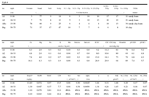
EGLI 4
Soil Classification:
WRB: Luvi-gleyic Phaeozem (Endoskeletic. Endostagnic)
Soil Taxonomy (1998): Clayey-skeletal Isohyperthermic Aquic Argiustoll
Authors: E. Mathé and A.M. Igué (23/4/98)
Location:
Eglimé village (toposequence 1). Département du Mono. Benin
7o 4.0145' N. 1o 39.9817' E; Elevation: 175 m
Land system:
Parent material: Migmatite (Basement Complex)
Physiography: Undulating peneplain (steepest slopes between 2 and 8 percent)
Position in landscape: the site is located on the lower valley side on a 300 m long linear slope (1 percent).
Vegetation: maize. cowpea. oil palm. mango trees
Climate: Subhumid Tropical with bimodal rainfall (1084 mm per annum) and average temperature 27.3 °C
Moisture regime:
Moisture condition at the time of examination: moist
Depth of groundwater level: >2 m
Drainage: imperfectly drained
Internal drainage: medium
Runoff: medium
Surface features:
Presence of surface stones or rock outcrops: none
Water erosion: sheet erosion. class 1
Other features:
Root distribution: up to 35 cm
Effective soil depth: 50 cm
Human influence: cultivation
Soil fauna: termite burrows. insect nests
Surface sealing and crusting: none
Surface cracking: none
Brief soil description:
50 cm of black to dark brown sandy loam over dark greyish yellow clay. gravelly below 18 cm. moderately developed granular structure near the surface and well developed subangular blocky below; well developed rooting system in the upper 50 cm.
Detailed soil description
Ap1 0-18 cm |
Black (10 YR 2/1) moist; sandy loam to sandy clay loam; friable; moderate fine to medium granular structure; many fine and medium vesicular and tubular pores; common fine. medium and coarse roots; gradual smooth boundary. |
Ap2 18-33 cm |
Brownish black (10 YR 3/2) moist; slightly gravelly sandy clay loam; friable; moderate fine to medium granular structure; many fine and medium vesicular and tubular pores; 5 percent 2-5 mm irregular red-black hard Fe/Mn nodules; common fine. medium and coarse roots; clear smooth boundary. |
AB 33-50 cm |
Dark brown (10 YR 3/3) moist; very gravelly sandy clay; friable; weak medium subangular blocky; common vesicular and interstitial pores; 50 percent 2-5 mm irregular red-black hard Fe/Mn nodules; 20 percent 10-50 mm angular yellow hard quartz gravels; few fine roots; clear wavy boundary. |
Btg 50-75 cm |
Dark greyish yellow (2.5 Y 4/2) moist; gravelly clay; firm when dry; structureless; few very fine and fine interstitial and tubular pores; 15 percent 10-50 mm angular white-yellow hard quartz gravels; few very fine roots. |
C >75 cm |
Olive black (5 Y 3/2) moist; very gravelly clay; very firm; structureless; 50 percent 1-50 mm angular white-yellow hard quartz gravels. |
Soil analysis of profile 7
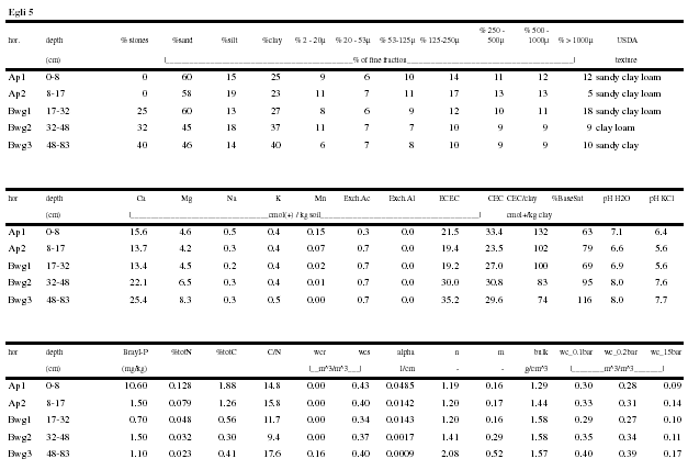
EGLI 5
Soil Classification:
WRB: Eutri-Endocalcari Gleysol ? (Epicalcaric-Mollic Cambisol)
Soil Taxonomy (1998): Clayey-skeletal Isohyperthermic Fluvaquentic Endoaquoll
Authors: A.M. Igué and E. Mathé (22/4/98)
Location:
Eglimé village (1 km north of Lagbave. toposequence 2). Département du Mono. Benin
7o 4.0632' N. 1o 40.2030' E; Elevation: 170 m
Land system:
Parent material: Gneiss (Basement Complex)
Physiography: Undulating peneplain (steepest slopes between 2 and 8 percent)
Position in landscape: the site is located on the lower valley side on a 200 m long linear slope (3 percent).
Vegetation: maize. oil palm
Climate: Subhumid Tropical with bimodal rainfall (1084 mm per annum) and average temperature 27.3 °C
Moisture regime:
Moisture condition at the time of examination: entire profile moist
Depth of groundwater level: >2 m
Drainage: imperfectly drained
Internal drainage: medium
Runoff: slow to medium
Surface features:
Presence of surface stones or rock outcrops: none
Water erosion: sheet erosion. class 1
Other features:
Root distribution: up to 60 cm
Effective soil depth: 85 cm
Human influence: cultivation
Soil fauna: termite burrows. insect nests
Surface sealing and crusting: none
Surface cracking: none
Brief soil description:
Brown clay with calcareous nodules from a depth of 30 cm onwards. with moderately developed polyedric subangular structure. overlaying weathering rock at 80 cm depth. Presence of slickensides and cracks.
Detailed soil description
Ap1 0-8 cm |
Brownish black (10 YR 3/1) moist; clay loam. friable when moist; moderate fine to medium granular; many fine vesicular and tubular pores; common fine. medium and coarse roots; clear smooth boundary. |
Ap2 8-17 cm |
Brownish black (10 YR 3/1) moist; loamy clay. fine; strong medium to coarse subangular blocky; common fine and medium vesicular. interstitial and tubular pores; common fine. medium and coarse roots; gradual smooth boundary. |
Bwg1 17-32 cm |
Brownish grey (10 YR 4/1) moist; slightly gravelly clay; very fine; strong medium to coarse subangular blocky ; common fine and medium vesicular. interstitial and tubular pores; 10 percent 2-10 mm angular red-black hard Fe/Mn nodules; 5 percent 2-10 mm angular yellow hard quartz gravels ; common medium and coarse roots; clear smooth boundary. |
Bwg2 32-48 cm |
Grey (5 Y 4/1) moist; slightly gravelly clay; extremely firm; strong coarse subangular blocky; few fine vesicular pores; 5 percent 2-10 mm irregular white hard CaCO3 nodules; few fine and medium roots; clear smooth boundary. |
Bwg3 48-83 cm |
Grey (5 Y 5/1) moist; slightly gravelly clay; extremely firm; strongly developed coarse subangular blocky; few fine vesicular pores; 10 percent 5-10 mm irregular white hard CaCO3 nodules; few fine and medium roots; clear smooth boundary. |
Cg > 83 cm |
Light grey (10 Y 7/2) moist; yellowish brown (2.5 Y 6/8) mottles; gravelly clay; 40 percent 2-5 mm red round quartz gravels; 1 percent 2-5 mm red Fe/Mn nodules. |
Soil analysis of profile 8
EGLI 7
Soil Classification:
WRB: Endoskeleti-Arenic Regosol (Eutric)
Soil Taxonomy (1998): Sandy Isoperthermic Typic Ustorthent
Authors: A.M. Igué and E. Mathé (24/4/98)
Location:
Eglimé main village (toposequence 3). Département du Mono. Benin
7°5.1236' N. 1°40.7640E ; Elevation: 160m
Land system:
Parent material: Gneiss (Basement Complex)
Physiography: Undulating peneplain (steepest slopes between 2 and 8 percent)
Position in land system: the site is located on the upper valley side on a 300m long linear slope (5 percent)
Vegetation: maize. cassava. oil palm
Climate: Subhumid Tropical with bimodal rainfall (1084 mm per annum) and average temperature 27.3°C
Moisture regime:
Moisture condition at the time of examination: entire profile moist
Depth of groundwater level: > 2m
Drainage: somewhat excessively drained
Internal drainage: rapid
Runoff: slow to medium
Surface features:
Presence of surface stones or rock outcrops: less than 2 percent of area covered with rock outcrops (35-100 m apart)
Water erosion: sheet erosion. class 1
Other features:
Root distribution: up to 50cm
Effective soil depth: 90cm
Human influence: cultivation
Soil fauna: krotovines. insect nests
Surface sealing and crusting: none
Surface cracking: none
Brief description:
yellowish brown sand over sandy clay loam. gravelly. very porous and weakly structure. overlaying weathering rock (saprolite) at 90cm.
Detailed soil description
Ap1 0-15 cm |
Brownish black (10 YR 2/2) moist; loamy sand ; friable; weak fine granular; many fine interstitial and tubular pores; common fine and medium roots ; gradual smooth boundary. |
Ap2 15-28 cm |
Dull yellowish brown (10 YR 4/3) moist; slightly gravelly sand ; friable ; weak fine granular; many fine interstitial and tubular pores ; 2 percent 2-10 mm angular hard quartz gravel; common fine roots ; clear smooth boundary. |
BE 28-57 cm |
Brown (7.5 YR 4/4) moist; slightly gravelly sand; friable; structureless; many fine vesicular ; interstitial and tubular pores ; 10 percent 2-10 mm angular yellow white hard stones ; medium and clear boundary. |
Bcs 57-80 cm |
Bright reddish brown (5 YR 5/6) moist; very gravelly loamy sand ; friable; weak medium subangular blocky; many fine interstitial and tubular pores ; 50 percent 5-15 mm irregular red/black hard Fe/Mn nodules ; 10 percent 5-10 mm angular yellow hard quartz gravels; few very fine and coarse roots; clear and wavy boundary. |
Btcs 80-90 cm |
Reddish brown (2.5 YR 4/6) moist; gravelly sandy clay loam ; friable ; moderate medium subangular blocky; many fine. medium and coarse vesicular. interstitial and tubular pores ; few very fine roots ; patchy thin clay/ Fe/Al cutans on pores and root channels ; 50 percent 5-15 mm irregular red/black hard Fe/Mn nodules ; 10 percent 5-10 mm angular yellow hard quartz gravels; clear and wavy boundary. |
C > 90 cm |
Saprolite. |
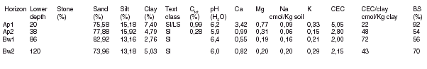
Soil analysis of profile 9 (Egli 7)
Horizon |
Lower Depth |
Stone(%) |
Sand(%) |
Silt(%) |
Clay(%) |
Text class |
Ctot(%). |
PH(H2O) |
Ca cmol/Kg soil |
Mg cmol/Kg clay |
Na(%) |
K |
CEC |
CEC/clay |
BS |
A1 |
15 |
7 |
84 |
12 |
4 |
ls |
0.58 |
6.5 |
2.5 |
1.2 |
0.0 |
0.2 |
3.3 |
78 |
122 |
A2 |
28 |
15 |
85 |
9 |
5 |
ls |
0.36 |
6.5 |
1.8 |
0.4 |
0.0 |
0.1 |
2.4 |
46 |
97 |
B |
57 |
20 |
82 |
12 |
6 |
ls |
0.21 |
6.7 |
1.4 |
0.4 |
0.0 |
0.1 |
2.4 |
40 |
83 |
|
Bc1 |
80 |
41 |
86 |
9 |
5 |
ls |
0.18 |
6.8 |
1.2 |
0.5 |
0.0 |
0.1 |
2.4 |
46 |
77 |
|
Bc2 |
90 |
58 |
77 |
8 |
15 |
sl |
0.18 |
6.2 |
1.6 |
0.9 |
0.0 |
0.1 |
4.8 |
31 |
56 |
EGLI 8
Soil Classification:
WRB: Eutri-Endogleyic Fluvisol
Soil Taxonomy (1998): Coarse-loamy Isohyperthermic Aquic Ustifluvent
Authors: A.M. Igué and E. Mathé (24/4/98)
Location:
Eglimé main village (toposequence 3). Département du Mono. Benin
7°4.9216' N. 1°40.9898E ; Elevation: 140m
Land system:
Parent material: Gneiss (Basement Complex)
Physiography: Undulating peneplain with steepest slopes between 2 and 8 percent
Position in landscape: the site is located on the valley bottom on a 150m long linear slope (2 percent)
Vegetation: maize. cowpea. cassava and oil palm
Climate: Subhumid Tropical with bimodal rainfall (1084 mm per annum) and average temperature 27.3°C.
Moisture regime:
Moisture condition at the time of examination: entire profile moist
Depth of groundwater level: > 2m
Drainage: poorly drained
Internal drainage: very slow
Runoff: slow
Surface features:
Presence of surface stones or rock outcrops: no outcrops (35-100m apart)
Water erosion: sheet erosion. class 1
Other features:
Root distribution: up to 35cm
Effective soil depth: 100cm
Human influence: cultivation
Soil fauna: insect nests
Surface sealing and crusting: none
Surface cracking: none
Brief description:
Deep brownish grey loamy sand over greyish yellow brown sandy clay loam. showing clear bright brown mottles below 50m. Granular structure near the surface. angular blocky below. Roots present up to 35cm.
Detailed soil description:
|
Ap1 0-17 cm |
Brownish black (10 YR 3/1) moist; few small faint sharp bright brown (7.5 YR 5/8) mottles. loamy sand. friable; weak fine granular; many fine vesicular and interstitial pores; many fine and medium roots ; gradual smooth boundary. |
|
Ap2 17-29 cm |
Brownish grey (10 YR 4/1) moist; common small distinct clear bright brown (7.5 YR 5/8) mottles; loamy sand; friable; moderate medium granular; many fine and medium vesicular and tubular pores ; many fine and medium roots ; gradual and wavy boundary. |
|
Cgt 29-52 cm |
Dull yellowish brown (10 YR 4/3) when moist. sandy loam ; many medium distinct clear greyish brown (7.5 YR 4/2) mottles. friable when moist ; moderately developed; medium subangular blocky structure ; many fine medium and coarse vesicular and tubular pores ; common fine and medium roots; clear wavy boundary. |
|
Cg2 52-68 cm |
Greyish yellow brown (5 YR 5/6) moist; many medium distinct clear greyish brown (7.5 YR 4/2) and bright brown (7.5 YR 5/2) mottles; sandy clay loam ; firm; moderate coarse subangular blocky; common fine and medium vesicular and tubular pores ; few fine roots ; clear smooth boundary. |
|
Cg3 68- 83 cm |
Greyish yellow brown (10 YR 4/2) moist; distinct clear brown (7.5 YR 4/4) mottles; gravelly sandy clay loam; firm; structureless ; common fine and medium vesicular and interstitial pores; 10 percent 2-10 mm irregular red/black hard Fe/Mn nodules ; 5 percent 5-10 mm angular yellow hard quartz gravels ; clear and smooth boundary. |
|
Cg4 83-100 cm |
Greyish yellow brown (10 YR 5/2) moist; abundant coarse distinct clear bright brown (7.5 YR 5/6); mottles; sandy clay; firm; structureless. massive; common fine and medium vesicular and tubular pores. |
Soil analysis of profile 10 (Egli 8)
|
Horizon |
Lower |
Stone |
Sand |
Silt |
Clay |
Text |
Ctot. |
pH |
Ca |
Mg |
Na |
K |
CEC |
CEC/clay |
BS |
|
|
depth |
(%) |
(%) |
(%) |
(%) |
class |
(%) |
(H2O) |
cmol/Kg soil |
|
|
cmol/Kg clay |
(%) |
|
|
|
Ap1 |
17 |
2 |
80 |
9 |
11 |
sl |
0.69 |
6.5 |
3.1 |
1.3 |
0.0 |
0.2 |
5.1 |
46 |
92 |
|
Ap2 |
29 |
4 |
86 |
8 |
7 |
ls |
0.27 |
6.1 |
1.4 |
0.6 |
0.0 |
0.1 |
0.2 |
3 |
178? |
|
Cg1 |
52 |
7 |
81 |
13 |
6 |
ls |
0.24 |
6.3 |
1.6 |
0.6 |
0.0 |
0.1 |
2.8 |
45 |
83 |
|
Cg2 |
68 |
10 |
71 |
15 |
14 |
sl |
0.23 |
6.3 |
2.6 |
1.3 |
0.0 |
0.1 |
5.6 |
40 |
72 |
|
Cg3 |
83 |
27 |
76 |
7 |
17 |
sl |
0.21 |
6.5 |
3.1 |
2.7 |
0.0 |
0.2 |
7.1 |
43 |
84 |
|
Cg4 |
100 |
21 |
74 |
7 |
19 |
sl |
0.17 |
6.6 |
3.9 |
2.1 |
0.0 |
0.2 |
9.6 |
51 |
66 |
EGLI 9
Soil Classification:
WRB: Epigleyi-bathipetrolithic Arenosol (Eutric)
Soil Taxonomy (1998): Isohyperthermic Aquic Ustipsamment
Authors: A.M. Igué and E. Mathé (6/5/98)
Location:
500m south of Kocouhoué. Eglimé area (toposequence 3). Département du Mono. Benin
7°3.571' N. 1°41.124E ; Elevation: 170m
Land system:
Parent material: Gneiss (Basement Complex)
Physiography: Undulating peneplain (steepest slopes between 2 and 8 percent)
Position in land system: the site is located on the upper valley side on a 500 m long linear slope (2 percent).
Vegetation: maize and oil palm
Climate: Subhumid Tropical with bimodal rainfall (1084 mm per annum) and average temperature 27.3°C.
Moisture regime:
Moisture condition at the time of examination: entire profile moist
Depth of groundwater level: 100 cm
Drainage: excessively drained
Internal drainage: rapid
Runoff: very slow
Surface features:
Presence of surface stones or rock outcrops: none
Water erosion: sheet erosion. class 1
Other features:
Root distribution: up to 100 cm
Effective soil depth: 100 cm
Human influence: cultivation
Surface sealing and crusting: none
Surface cracking: none
Brief description:
Grevish brown loamy sand with hydromorphic mottles. moderately well structured. very porous and well developed rooting system on petroferric layer at 100 m.
Detailed soil description:
|
Ah 0- 6cm |
Black (10YR2/1) when moist, loamy sand; friable when moist; weakly developed fine granular structure; many fine and medium vesicular and tubular pores; many very fine and medium roots; clear smooth boundary. |
|
ABg 16-32cm |
Brownish black (10 YR 3/2) when moist, loamy sand; few medium faint clear brown (7.5 YR 4/6) mottles; friable when moist; moderately developed medium subangular blocky structure; many fine and medium vesicular and interstitial pores; many fine and medium roots; gradual smooth boundary. |
|
ABg1 32-58cm |
Dull yellowish brown black (10 YR 5/2) when moist, slightly gravelly. loamy sand; many medium distinct clear bright brown (7.5 YR 5/6) mottles; friable when moist; weakly developed to medium subangular blocky structure; many fine and medium vesicular and interstitial pores; many fine and medium roots; gradual smooth boundary. |
|
ABg2 58-80cm |
Greyish yellow brown (10 YR 5/2) when moist, slightly gravelly loamy sand; many medium distinct clear bright brown (7.5 YR 5/6) mottles; friable when moist; weakly developed fine to medium subangular blocky structure; many fine and medium vesicular and interstitial pores; 5% 5-15 mm irregular red-black hard Fe/Mn nodules; many fine and medium roots; gradual wavy boundary. |
|
Bg2 80-100cm |
Greyish yellow brown (10 YR 6/2) when moist, gravelly sandy loam; many medium distinct clear bright brown (7.5 YR 5/6) mottles; friable when moist; weakly developed. fine to medium subangular blocky structure; many fine and medium vesicular and interstitial and tubular pores; 20% 5-15 mm irregular red-black hard Fe/Mn nodules; few fine and medium roots; gradual wavy boundary. |
|
Bsm > 100cm |
Petroferric layer. |
Soil analysis of profile 11 (Egli 9)
|
Horizon |
Lower |
Stone |
Sand |
Silt |
Clay |
Text |
Ctot. |
pH |
Ca |
Mg |
Na |
K |
CEC |
CEC/clay |
BS |
|
|
depth |
(%) |
(%) |
(%) |
(%) |
class |
(%) |
(H2O) |
cmol/Kg soil |
|
|
cmol/Kg clay |
(%) |
||
|
Ah |
16 |
1 |
86 |
7 |
7 |
ls |
0.87 |
6.9 |
3.7 |
1.1 |
0.0 |
0.3 |
4.6 |
66 |
114 |
|
ABg |
32 |
2 |
88 |
6 |
7 |
ls |
0.41 |
6.7 |
2.2 |
0.6 |
0.0 |
0.1 |
2.8 |
42 |
104 |
|
ABg1 |
58 |
4 |
88 |
8 |
4 |
s |
0.19 |
6.7 |
1.3 |
0.2 |
0.0 |
0.1 |
1.7 |
39 |
93 |
|
ABg2 |
90 |
5 |
88 |
7 |
5 |
s |
0.1 |
6.8 |
0.9 |
0.2 |
0.0 |
0.1 |
1.8 |
37 |
63 |
|
ABg3 |
100 |
8 |
89 |
7 |
4 |
s |
0.1 |
6.7 |
0.7 |
0.2 |
0.0 |
0.1 |
1.9 |
54 |
51 |
DAIG M 1
Classification:
FAO: Arénosol gleyique
CPCS: Sol sableux hydromorphe
Prospection: BENSOTER
Date de la description: 12/05/97
Auteur: A.M. Igué
Localisation: Tagui à 100 m de la colline
Altitude: 180 m
Géomorphologie: Vallée entre collines
Pente: quasi nulle (1 %)
Végétation: Savane arbustive
Utilisation du sol : Culture maïs. manioc. manguier.
Informations générales:
Roche-mère: Colluvions
Drainage: légèrement excessif
Erosion: en nappe
Influence humaine: labour
Description des horizons:
|
Ap 0-20 cm |
Brun foncé (7.5 YR 3/2); sable fin limoneux; structure faiblement développée polyédrique subangulaire; friable; très poreux; assez nombreuses racines; transition distincte et régulière. |
|
Bg1 20-38 cm |
Brun grisâtre foncé (10 YR 4/2) ; taches 20 percent brun foncé (7.5 YR 3/2). sable fin limoneux; structure faiblement développée polyédrique subangulaire; friable très poreux; assez nombreuses racines; transition distincte et régulière |
|
Bg2 38-86 cm |
Brun foncé à frais (10 YR 5/2); taches 40 percent brun foncé (7.5 YR 4/4); sable fin; structure moyennement développée polyédrique subangulaire; friable; très poreux; peu nombreuses racines ; transition graduelle et régulière. |
|
Bg3 86-120 cm |
Brun foncé (10 YR 5/2) taches brun foncé (10 YR 3/3) sable fin; structure massive; peu ferme; très poreux; rares racines |
Résultats analytiques: profil 12 (Daig M1)
DAIG M 2
Classification:
FAO: Solonetz verti-stagnique
CPCS: Sol gris argileux alcalin
Prospection: BENSOTER
Date de la description: 12/05/97
Auteurs: A.M. Igue & Offi
Localisation: entre Tagui et Volontaire.
Altitude: 160 m position
Géomorphologie: pénéplaine
Pente: 1 pour cent
Végétation: Savane
Utilisation du sol: anacardiers, niébé, piment, arachide, manioc;
Informations générales:
Roche-mère: gneiss à amphibolite
Drainage: pauvre / imparfait
Etat hydrique du sol: frais
Profondeur de la nappe phréatique: non visible
Traces d'érosion: en nappe
Influence humaine: plantation
Description des horizons:
|
Ap1 0 - 15 cm |
Brun grisâtre très foncé (10 YR 3/2); sable limoneux. grumeleux; friable; très poreux; nombreuses racines; transition ondulée. |
|
AE15-20 /36 cm |
Brun foncé (10 YR 3/3); sable limoneux; structure moyennement développée polyédrique subangulaire; friable; très poreux; nombreux nodules et concrétions Fe-Mn; assez nombreuses racines; transition ondulée et discontinue. |
|
Bgn1 20/36-40/50 cm |
Brun grisâtre (2.5 YR 5/2) ; taches (10 YR 5/2) ; argile ; structure en colonnette et prismatique; peu nombreuses concrétions Fe-Mn ; transition distincte et irrégulière |
|
Bgn2 40/50-75 cm |
Brun olive (2.5 Y 5/4) argile; structure massive; transition graduelle |
|
BCn 75 - 110 cm |
Brun olive clair (2.5 YR 5/4); argile; structure massive; débris de roche. |
Résultats analytiques: profil 13 (Daig M2)
|
Horizon |
Lower |
Stone |
Sand |
Silt |
Clay |
Text |
Ctot. |
pH |
Ca |
Mg |
Na |
K |
CEC |
CEC/clay |
BS |
|
|
depth |
(%) |
(%) |
(%) |
(%) |
class |
(%) |
(H2O) |
cmol/Kg soil |
|
|
cmol/Kg clay |
(%) |
|
|
|
Ap1 |
15 |
7 |
59 |
27 |
11 |
LS |
0.98 |
6.5 |
1.9 |
1.3 |
0.4 |
0.2 |
6.1 |
3 |
61 |
|
AE |
20 |
9 |
67 |
18 |
12 |
LS |
0.61 |
6.6 |
1.2 |
1.1 |
0.6 |
0.1 |
6.8 |
7 |
43 |
|
Bgn1 |
40 |
30 |
45 |
26 |
28 |
LAS |
0.67 |
7.3 |
1.6 |
4.6 |
3.9 |
0.2 |
12.7 |
28 |
80 |
|
Bgn2 |
75 |
45 |
25 |
30 |
45 |
A |
8.7 |
3.9 |
13.1 |
9.5 |
0.4 |
21.2 |
59 |
100 | |
|
BCn |
120 |
44 |
26 |
25 |
50 |
A |
8.7 |
2.8 |
14.1 |
10.7 |
0.4 |
24.0 |
56 |
100 |
DAIG M 3
Classification:
FAO: Lixisol ferrique (Lixisol plinthique)
CPCS : Sol rouge gravillonnaire
Prospection: BENSOTER
Date de la description: 12/05/97
Auteur: A.M. Igué
Localisation: 1.8 km de Erokoari vers Itagui
Altitude: 170 m
Géomorphologie: interfluve - versant (High peneplain)
Pente: 2-3 pour cent
Végétation: savane
Utilisation du sol: maïs. anacardiers. manguiers.
Informations générales:
Roche-mère: migmatite.
Drainage: modéré à normal
Etat hydrique du sol: frais
Profondeur de la nappe phréatique: non visible
Traces d'érosion: en nappe
Description des horizons :
Ap 0-12/30 cm Brun foncé (7,5 YR 3/4). sable fin-limoneux; structure faiblement développée polyédrique subangulaire; friable; très poreux; sans gravillons; transition distincte et irrégulière.
BEc 12/30-32/40 cm Rouge jaunâtre (5 YR 4/6). sable fin limoneux; structure autour des gravillons; friable; très poreux; 60 pour cent de concrétions Fe -Mn et quartz; transition distincte et régulière.
Btcs1 32/40-60 cm Rouge (2,5 YR 4/6). limon-argilo-sableux à argile sableuse; structure massive; 60 à 80 pour cent de concrétions Fe-Mn et quartz; transition distincte et régulière.
Btcs2 60- 20 cm Carapace; argile sableuse; massive avec structure de la roche et débris de roche; nodules Fe- Mn et quartz 60-80 pour cent.
Résultats analytiques: profil 14 (Daig M3)
|
Horizon |
Lower |
Stone |
Sand |
Silt |
Clay |
Text |
Ctot. |
pH |
Ca |
Mg |
Na |
K |
CEC |
CEC/clay |
BS |
|
|
depth |
(%) |
(%) |
(%) |
(%) |
class |
(%) |
(H2O) |
cmol/Kg soil |
|
|
cmol/Kg clay |
(%) |
|
|
|
Ap |
12 |
27 |
78 |
15 |
5 |
LS |
0.43 |
6,2 |
3,1 |
0,9 |
0,1 |
0,6 |
4,9 |
68 |
97 |
|
AB |
32 |
82 |
67 |
12 |
12 |
LS |
0.39 |
6,2 |
2,1 |
0,8 |
0,2 |
0,6 |
4,1 |
23 |
90 |
|
Bts |
54 |
93 |
49 |
34 |
34 |
SL |
6,8 |
4,1 |
2,1 |
0,2 |
0,5 |
14,8 |
44 |
46 | |
|
Btc |
80 |
26 |
67 |
21 |
21 |
LAS |
6,6 |
2,8 |
1,6 |
0,2 |
0,5 |
9,6 |
46 |
53 | |
|
BCc |
120 |
80 |
60 |
26 |
26 |
LAS |
6,4 |
3,8 |
2,2 |
0,2 |
3,6 |
13,2 |
51 |
74 |
DAIG M 5
Classification:
FAO: Cambisol gleyique
CPCS: Sol brun argileux eutrophe hydromorphe
Prospection: BENSOTER
Date de la description: 16/04/1997
Auteurs: A.M. Igué et Offi
Localisation: entre Ekokoari et colline Sozoun
Altitude: 160 m
Géomorphologie: bas de pente de colline
Pente: 2 à 3 pour cent
Végétation: savane arbustive. pâturage
Utilisation du sol: coton. pâturage
Informations générales:
Roche-mère: basalte
Drainage: imparfait
Profondeur de la nappe phréatique: non visible
Traces d'érosion: en nappe
Description des horizons:
|
0 - 20 cm |
Brun jaunâtre foncé (10 YR 3/3) et (2.5 YR 3/4). taches 10 pour cent; limon sableux; structure moyennement développée polyédrique subangulaire; friable; très poreux; nombreuses fines racines; transition distincte et régulière. |
|
20 - 32 cm |
Brun jaunâtre (10 YR 5/4). taches 10pour cent (5 YR 3/3); limon argilo-sableux; structure moyennement développée polyédrique subangulaire; friable; assez nombreux pores de toutes tailles; nombreuses fines et moyennes racines; transition distincte et régulière. |
|
|
|
|
32 - 52 cm |
Brun olive (2,5 YR 4/4). taches 40 pour cent (5 YR 4/8); argile; structure massive. faiblement polyédrique subangulaire; très ferme; peu poreux; peu nombreuses racines; transition distincte et régulière. |
|
52 - 100 cm |
Brun olive (2,5 YR 4/4). argile; petites concrétions ferromanganiques 10 pour cent. structure massive; très ferme; peu poreux; rares racines; petites concrétions ferromanganiques 10 %. |
Résultats analytiques: profil 15 (Daig M5)
|
Horizon |
Lower |
Stone |
Sand |
Silt |
Clay |
Text |
Ctot. |
pH |
Ca |
Mg |
Na |
K |
CEC |
CEC/clay |
BS |
|
|
depth |
(%) |
(%) |
(%) |
(%) |
class |
(%) |
(H2O) |
cmol/Kg soil |
|
|
cmol/Kg clay |
(%) |
||
|
Ah |
20 |
4 |
69 |
23 |
8 |
LS |
0,57 |
7,2 |
2,6 |
0,8 |
0,2 |
0,2 |
5,3 |
66 |
73 |
|
Abg |
32 |
6 |
53 |
23 |
23 |
LAS |
0,50 |
6,8 |
4,2 |
1,7 |
0,7 |
0,2 |
11,0 |
48 |
62 |
|
Bwg |
52 |
8 |
34 |
27 |
39 |
LS |
0,46 |
6,8 |
7,2 |
3,2 |
1,5 |
0,2 |
19,4 |
50 |
62 |
|
CBwg |
100 |
11 |
29 |
22 |
48 |
LS |
7,3 |
11,9 |
1,7 |
2,9 |
0,5 |
27,8 |
58 |
72 |
BJCS6
Classification:
FAO: Cambisol sodi-vertique
CPCS: Sol brun eutrophe tropical peu évolué ; vertique
Auteurs: A.M. Igue et G.Ch. Gnangoli
Position: 7 52'.708 Long-2° 06'.749 Lat.
Localisation: dans la teckeraie. à 100 m environ de la colline sur l'axe Dassa - Logozohè à 2 km avant Logozohè.
Roche-mère: roche basique (microsyénite avec amphibole et microcline ou gabbros quartzifères).
Géomorphologie: haut de versant.
Hydrologie: profil à drainage modéré.
Pédologie: couverture discontinue. sol brun eutrophe peu évolué.
Climat: subéquatorial avec influence du climat du type soudano-guinéen.
Température: moyenne annuelle: 27°C; pluviométrie: 1200 mm
Végétation et occupation humaine: teckeraie
Aptitude culturale:
Ce sont des sols très riches chimiquement qui présentent en outre des propriétés physiques excellentes dues à une argile à très bonne structure. Les teneurs en eau compensent largement la faible profondeur d'utilisation du sol par les racines. Ces sols conviendraient à toutes les cultures exigeantes en eau.
Description synthétique:
Sol brun limoneux sableux sur argile brune à brun olive. à structure polyédrique à massive. contenant des concrétions noires (plomb de chasse) et des nodules calcaires de 1 à 3cm de diamètre ; apparition de la roche à 160 cm.
Description morphologique:
|
A11 0 - 12cm |
Horizon brun foncé 10 YR 2/2 à l'état frais; limon; structure grumeleuse fine et moyenne; meuble; très nombreux pores très fins et fins; très nombreuses racines fines et moyennes; peu nombreuses grosses racines; activité biologique intense; transition distincte et régulière. |
|
A12 12-40cm |
Horizon brun grisâtre 10 YR 4/2 à l'état frais; argile ; structure polyédrique subangulaire à cubique. peu nombreux pores très fins. fins et moyens; assez nombreuses racines de toutes tailles; peu nombreuses concrétions ferro-manganifères. et peu nombreux graviers de quartz; activité biologique assez intense; transition distincte et progressive. |
|
(B) 40-80cm |
Horizon brun grisâtre foncé 2.5 Y 4/2 à l'état frais; argile; structure massive à polyédrique subangulaire; peu nombreux pores très fins et fins; peu nombreuses concrétions (ou plomb de chasse). et peu nombreux graviers de quartz ; activité biologique peu intense; transition distincte et progressive. |
|
Ckc 80- 60cm |
Horizon brun olive foncé 2.5 Y 4/4 à l'état frais; argile d'altération ; structure massive et compacte; peu nombreux nodules calcaires ou blancs. et peu nombreuses concrétions noires; activité biologique peu intense; transition distincte et irrégulière. |
|
160- 190cm |
Horizon roche en voie d'altération. |
Résultats analytiques : profil 16 (BJCS6)
|
Horizon |
A11 |
A12 |
Bw |
C kc |
|
Profondeur cm |
0-12 |
12-40 |
40-80 |
80-160 |
|
Refus % (2 mm) |
0,6 |
2,6 |
3,1 |
1,2 |
|
0 - 2 µ % |
11,87 |
49,85 |
53,23 |
54,76 |
|
2 - 20 µ % |
15,49 |
17,71 |
17,14 |
18,62 |
|
20 - 50 µ % |
26,51 |
14,12 |
12,08 |
12,81 |
|
50 - 200 µ % |
36,22 |
11,38 |
7,70 |
8,27 |
|
200 - 2000 µ % |
9,21 |
5,79 |
5,25 |
5,35 |
|
Humidité |
- |
- |
- |
- |
|
pF 2.5 |
20,3 |
44,3 |
48,4 |
- |
|
pF 4,2 |
9,7 |
28,3 |
30,4 |
- |
|
Eau utile |
10,6 |
16,0 |
18,0 |
- |
|
C % |
1,43 |
0,74 |
0,41 |
- |
|
N % |
0,107 |
0,063 |
0,042 |
- |
|
C/N |
13,4 |
11,7 |
9,8 |
- |
|
M.O % |
2,47 |
1,28 |
0,71 |
- |
|
pH eau (1/2,5) |
7,2 |
7,4 |
8,7 |
9,2 |
|
pH KCI (1/2,5) |
5,7 |
5,5 |
6,8 |
7,2 |
|
Ca ++ éch. méq/100g |
6,73 |
10,67 |
11,85 |
16,97 |
|
Mg++ éch. méq/100g |
4,13 |
13,48 |
14,97 |
16,81 |
|
K- éch. méq/100g |
0,43 |
0,55 |
0,54 |
0,45 |
|
Na- éch. méq/100g |
0,41 |
2,89 |
4,13 |
5,61 |
|
Somme cations |
11,70 |
27,59 |
31,49 |
39,84 |
|
CEC méq/100g |
12,00 |
29,00 |
20,45 |
30,70 |
|
CEC Argile (méq) |
59 |
53 |
36 |
56 |
|
% V = ST x 100 |
98 |
92 |
100 |
100 |
|
P. ass. Truog ppm |
7 |
2 |
2 |
3 |
|
ESP % |
3 |
10 |
20 |
18 |
BJCS 7
Classification:
FAO: Gleysol verti-eutrique
CPCS: Sol hydromorphe peu humifère à pseudogley
Auteurs: Igue. A.M.; Gnangoli. G. Ch.
Localisation: 1,3 km de l'axe Dassa-Logozohè en allant vers Glazoué
Roche-mère: roche basique (microsyénites avec amphiboles ou gabbros quartzifères)
Géomorphologie: bas de versant de la colline de Logozohè sur une pente de 2 pour cent
Hydrologie: profil à drainage mi-parfait
Pédologie: couverture pédologique discontinue. sol hydromorphe à pseudogley
Climat: subéquatorial avec influence du climat du type soudano-guinéen ;
Température: moyenne annuelle 27° C; pluviométrie 1200 mm
Végétation: savane arbustive a Pteurocarpus. Terminalia. Combretum. Tectona
Aptitude culturale:
Ces sols conviennent très bien pour les plantes supportant un engorgement partiel (bananier. riz. maïs). De plus la présence de limon en fait des terres faciles à cultiver.
Description synthétique:
Sol brun jaunâtre. limon sableux sur argile concrétionnée et blanchie a mi-profondeur avec d'assez nombreuses taches ocre-rouille à rouges démarrant après les 12 premiers centimètres. l'horizon argileux de profondeur contient des nodules de calcaire et des concrétions en forme de plomb de chasse.
Description morphologique:
|
Ah1 0 - 5 cm |
Horizon brun foncé (10 YR 3/3) à l'état frais. limon sableux ou sable fin limoneux. structure faiblement développée polyédrique subangulaire. fin à moyen; meuble. très nombreux pores. très fins et fins et peu nombreux moyens pores; nombreuses racines très fines et fines; peu nombreuses moyennes racines; activité biologique peu intense. nids de fourmis; transition distincte et régulière. |
|
Ah2 5-12 cm |
Horizon brun olive clair (2,5 Y 5/4) à l'état frais. à brun jaunâtre clair (10 YR 6/4); limon sableux. friable; structure faiblement développée polyédrique subangulaire. fin à moyen. très nombreux pores très fins et fins et nombreux moyens pores; assez nombreuses fines et moyennes racines. activité biologique assez intense. nids de fourmis ; transition distincte et régulière. |
|
Bg 12-32 cm |
Horizon brun jaunâtre clair (2,5 Y 6/4). peu nombreuses taches ocre rouille (7,5 YR 5/6) devenant assez nombreuses à la base de l'horizon. fines (2 mm). distinctes et assez nettes; limon argileux. structure moyenne développée polyédrique subangulaire; friable. nombreux pores très fins et fins. et peu nombreux moyens pores; assez nombreuses fines et moyennes racines et quelques grosses racines. très peu nombreux nodules ferrugineux; activité biologique intense. krotovines. galeries de fourmis. racines pourries; transition distincte et ondulée. |
|
Bgcs 32-58 cm |
Horizon blanchi ou gris clair (10YR 7/2) à l'état frais. assez nombreuses taches ocres (7,5YR 5/8) fines à moyennes. distinctes. assez nettes; argile sableuse; structure moyennement développée polyédrique subangulaire. fin à moyen. peu collant; assez nombreux pores fins et moyens; assez nombreuses racines fines à moyennes et quelques grosses racines. très nombreuses concrétions à patines. ferro-manganifères petites à grosses. dures. de couleur rouge noirâtre; activité biologique peu intense; quelques galeries de fourmis; transition distincte et ondulée. |
|
Bg 58-70 cm: |
Horizon gris brunâtre clair ( 2,5Y 6/2). nombreuses taches rouges (2,5YR 4/6) fines. distinctes. assez nettes; argile; structure massive à débit polyédrique. peu collant à l'état humide et ferme à l'état frais; présence de minces cutans argileux. localisés à la face des agrégats. peu nombreuses concrétions ferro-manganifères. activité biologique intense; transition distincte et régulière. |
|
58- 180cm |
Horizon brun olive (2,5Y 4/4) argileux; on observe quelques taches rouges diffuses. peu nettes. à la partie supérieure de l'horizon; structure massive compacte; peu nombreux pores fins et moyens. rares racines ; peu nombreuses concrétions ferro-manganifères petites à grosses. dures. de forme arrondie. de couleur noirâtre; peu nombreux nodules calcaires. de couleur blanchâtre. de 1 à 3 cm de diamètre ; assez nombreuses fines fentes subverticales et horizontales. |
Résultats analytiques: profil 17 (BJCS7)
|
Horizon |
Ah1 |
Ah2 |
Bg |
Bgcs |
Bg |
Ck |
|
Profondeur cm |
0-5 |
5-12 |
12-32 |
32-58 |
58-70 |
70-180 |
|
Refus % (2 mm) |
0,2 |
0,2 |
1,0 |
27,3 |
7,4 |
4,0 |
|
0 - 2 µ % |
10,28 |
10,83 |
21,13 |
28,26 |
54,34 |
51,45 |
|
2 - 20 µ % |
20,56 |
20,37 |
23,22 |
22,08 |
15,65 |
12,80 |
|
20 - 50 µ % |
26,64 |
23,51 |
23,04 |
17,16 |
12,11 |
14,37 |
|
50 - 200 µ % |
40,86 |
36,63 |
25,51 |
19,45 |
11,48 |
14,64 |
|
200 - 2000 µ % |
2,17 |
7,38 |
5,94 |
11,81 |
7,00 |
6,97 |
|
Humidité |
- |
- |
- |
- |
- |
- |
|
pF 2,5 |
18,6 |
13,5 |
- |
- |
- |
- |
|
pF 4,2 |
6,8 |
6,0 |
- |
- |
- |
- |
|
Eau utile |
11,8 |
7,5 |
- |
- |
- |
- |
|
C % |
0,96 |
0,60 |
0,49 |
- |
- |
- |
|
N % |
0,074 |
0,053 |
0,051 |
- |
- |
- |
|
C/N |
13,0 |
11,3 |
9,6 |
- |
- |
- |
|
M.O % |
1,66 |
1,03 |
0,84 |
- |
- |
- |
|
pH eau (1/2,5) |
7,1 |
6,4 |
6,6 |
6,7 |
6,8 |
7,9 |
|
pH KCI (1/2,5) |
5,7 |
4,9 |
4,6 |
4,6 |
4,6 |
6,4 |
|
Ca ++ éch. méq/100g |
3,97 |
2,60 |
4,29 |
5,68 |
12,23 |
18,44 |
|
Mg++ éch. méq/100g |
1,51 |
1,10 |
1,58 |
2,03 |
4,40 |
5,90 |
|
K- éch. méq/100g |
0,37 |
0,25 |
0,29 |
0,37 |
0,44 |
0,38 |
|
Na- éch. méq/100g |
0,18 |
0,21 |
0,34 |
0,51 |
1,01 |
1,80 |
|
Somme cations |
6,03 |
4,16 |
6,50 |
8,59 |
18,08 |
26,52 |
|
CEC méq/100g |
9,20 |
6,00 |
9,05 |
12,65 |
25,10 |
25,10 |
|
CEC Argile (méq) |
57 |
36 |
35 |
45 |
46 |
49 |
|
% V = ST x 100 |
66 |
69 |
72 |
68 |
72 |
>100 |
|
P. ass. Truog ppm |
2 |
1 |
1 |
|||
|
ESP % |
2 |
4 |
4 |
4 |
4 |
7 |
