![]()
![]()
![]()
The irrigated areas are located in three climatic zones, northern, central and southern.
1. The northern climatic zone comprises the Republic of Karakalpakstan, the Khorezm region and the foothill districts of Tashkent and Samarkand. This zone has the shortest vegetative growth period (180 to 200 days); the sum of temperatures does not exceed 3 600 °C to 4 000 °C, i.e. the sum of temperatures above 10 °C during the growing period. In this zone crops such as cotton, rice, melon, vegetables and different fruit trees are grown. The summer temperatures range from 35 °C to 42 °C during the day and 20 °C to 28 °C at night.
The first subzone of the northern climatic zone includes the northern districts of the Republic of Karakalpakstan and Khorezm region. The soils are old-irrigated, hard and loamy. The average water penetration is low and the water is highly saline. The ground water has a high salt content (12 to 30 g/litre).
The second subzone (foothill areas of Tashkent and Samarkand) of the northern climatic zone has sierozems and sierozem meadow soils, with a low salt content. The ground water contains little salt (1 to 3 g/litre); the vegetative period is of 200 days; the sum of temperatures does not exceed 3 600 °C to 4 000 °C; the amount of rainfall is 360 to 400 mm a year, falling mostly in the winter and early spring.
2. The central climatic zone includes the Fergana valley, Tashkent and Samarkand. In this zone, the vegetative period is 200 to 220 days, the sum of temperatures 4 000 °C to 4 200 °C; evaporation is higher than rainfall.
In this climatic zone, crops such as cotton, wheat, barley, grapes, tobacco, potatoes, tomatoes and other vegetable and fruit crops are grown.
In the first subzone of the central climatic zone (the Fergana Valley, Tashkent, Sir-Darya and Samarkand regions), the soils are gleysols and meadow soils, non-saline or of low salinity, with good hydro-physical properties. The vegetative period is of 190 to 200 days, rainfall 320 to 380 mm, falling mainly in winter and spring. The sum of positive temperatures is 4 000 °C to 4 200 °C.
In the second subzone (Sir-Darya, Jizzakh and Samarkand regions), the vegetative period is 190 to 200 days, the rainfall 240-270 mm per year. The soils are typical gleysols, non-saline, gleysol-meadow soils and meadow soils.
In the third subzone (the new irrigation zone of Jizzakh, Samarkand and part of Kashkadarya), the soils are typical gleysols and meadow soils, non-saline or of low salinity. In this zone, the average temperature fluctuates during the vegetative period from 16 °C to 20 °C, the sum of temperatures is 4 200 °C to 4 400 °C, the annual rainfall from 220 to 240 mm, 75 percent falling outside the vegetative period.
3. The southern climatic zone includes the Bukhara and Surhandarya regions. The vegetative period is 240 to 260 days and the sum of temperatures 4 600 °C to 5 000 °C.
In this zone, subtropical crops such as melons, fine fibre cotton and various vegetable and fruit crops are grown.
In the first subzone (Kashkadarya region and the southern districts of Bukhara), typical gleysols, light gleysols and desert soils are well developed. The climatic conditions of this subzone are characterized by a long vegetative period of 230 to 260 days; the rainfall of 140 to 180 mm per year is insufficient. The maximum temperature reaches 45 °C to 50 °C. This explains the high degree of evaporation.
In the second subzone, soils are meadow gleysols, old-irrigated land, slightly alkaline. The climate is severely continental. The vegetative period is 250 to 260 days and the annual rainfall does not exceed 80 to 120 mm.
In the third subzone, subtropical crops and late ripening varieties of fine fibre cotton are grown on irrigated land. The vegetative period is 250 to 260 days; rainfall is insufficient at 70 to 100 mm.
According to the regional classification system, Uzbekistan is in the Middle Asian soil climatic zone, characterized by a continental (dry) climate, with soils that differ from those of the more northern regions of Euro-Asia.
Information on the main soil types in the different regions is given in the Annex.
The main factor in the qualitative assessment of land is its fertility and this is determined by 'bonitation'. The 'bonitation' of land is the comparative assessment of the land quality, and productivity with a representative level of agricultural activity. Bonitation involves an analysis of the soil properties, both natural and human-induced, that determine its crop carrying capacity, both its natural productive capacity and that obtained through agricultural activities.
The bonitation carried out in the period 1989 to 1990 for irrigated land has a 100-degree scale. The highest score is attributed to soils with the highest fertility, or 40 centners of cotton per hectare. A yielding capacity of 0.4 centners/hectare gives a value of one. Table 4 classifies the land according to these assessments.
The categories of land suitable for irrigation (Table 5) are defined as:
i. Very good land capable of producing 81-100 percent of the potential yield
ii. Good land capable of producing 61-80 percent of the potential yield
iii. Moderate quality land capable of producing 41-60 percent of potential yield
iv. and iv. Poor land capable of producing 40 percent of potential yield
Table 4
Land suitable for irrigation ('000 ha)
|
Zone |
Total area |
Total area suitable for irrigation |
Present irrigated area |
|
Karakalpakstan Republic |
16 659 |
1 540 |
502 |
|
Oblasts |
|||
|
Andijan |
423 |
70 |
282 |
|
Bukhara |
14 335 |
1 700 |
347 |
|
Djizak |
2 049 |
560 |
288 |
|
Kashkadarya |
2 858 |
1 320 |
470 |
|
Namangan |
744 |
90 |
273 |
|
Samarkand |
2 467 |
870 |
407 |
|
Surkhandarya |
2 010 |
170 |
315 |
|
Sirdarya |
500 |
150 |
300 |
|
Tashkent |
1 558 |
170 |
401 |
|
Fergana |
676 |
150 |
355 |
|
Khorezm |
605 |
240 |
262 |
|
Total |
44 884 |
7 030 |
4 202 |
Table 5
Quality of land suitable for irrigation
|
Zone |
Quality of land suitable for irrigation(% of irrigated land) |
|||
|
I |
II |
III |
IV, V |
|
|
Karakalpakstan Republic |
0 |
7 |
39 |
54 |
|
Oblasts |
||||
|
Andijan |
16 |
54 |
20 |
10 |
|
Bukhara |
12 |
37 |
32 |
19 |
|
Djizak |
2 |
29 |
54 |
15 |
|
Kashkadarya |
3 |
24 |
60 |
13 |
|
Namangan |
26 |
30 |
26 |
18 |
|
Samarkand |
19 |
51 |
24 |
6 |
|
Surkhandarya |
25 |
46 |
21 |
8 |
|
Sirdarya |
1 |
33 |
41 |
24 |
|
Tashkent |
18 |
47 |
30 |
5 |
|
Fergana |
29 |
31 |
23 |
17 |
|
Khorezm |
40 |
26 |
19 |
15 |
Tables 6 and 7 show different land qualities and grades of land by region.
Table 6
Areas of land of different qualities by region ('000 ha)
|
Zone |
Poor |
Low |
Average |
Good |
Best |
Total |
|
Karakalpakstan Republic |
2 |
267 |
119 |
31 |
0 |
419 |
|
Oblasts |
||||||
|
Andijan |
* |
36 |
76 |
109 |
9 |
230 |
|
Bukhara |
* |
49 |
69 |
92 |
1 |
211 |
|
Djizak |
* |
44 |
192 |
38 |
3 |
277 |
|
Navoiy |
2 |
25 |
36 |
33 |
2 |
98 |
|
Namangan |
* |
59 |
84 |
66 |
19 |
228 |
|
Samarkand |
* |
31 |
160 |
97 |
18 |
306 |
|
Sirdarya |
* |
70 |
125 |
34 |
0 |
229 |
|
Surkhandarya |
2 |
54 |
110 |
86 |
18 |
270 |
|
Tashkent |
0 |
39 |
153 |
120 |
16 |
328 |
|
Fergana |
1 |
67 |
115 |
101 |
6 |
290 |
|
Khorezm |
2 |
42 |
78 |
79 |
5 |
206 |
|
Kashkadarya |
0 |
75 |
285 |
74 |
9 |
443 |
|
Total |
9 |
858 |
1 602 |
960 |
106 |
3 535 |
* Below 500 ha.
Table 7
Average grades of land by region
|
Zone |
Average grade* |
|
Karakalpakstan Republic |
41 % |
|
Oblasts |
|
|
Andijan |
60 % |
|
Bukhara |
53 % |
|
Djizak |
50 % |
|
Navoiy |
52 % |
|
Namangan |
59 % |
|
Samarkand |
57 % |
|
Sirdarya |
49 % |
|
Surkhandarya |
60 % |
|
Tashkent |
59 % |
|
Fergana |
56 % |
|
Khorezm |
54 % |
|
Kashkadarya |
51 % |
|
Total |
55 % |
* Average grade: the percentage ratio of the crop (cotton) yield obtained in a given zone compared with the crop yield on the land of best quality across the country.
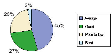
Figure 5: Land of different qualities in Uzbekistan
The Central Asian countries, especially Uzbekistan, are important cotton exporters. The area of irrigated land grew by more than 3.0 million hectares between 1950 and 1988, mostly in Uzbekistan and Turkmenistan. In order to support this massive increase in the irrigated area, water withdrawals were made indiscriminately, reducing the river flow until 97 percent of annual water resources were consumed, leaving only four cubic kilometers to flow into the Aral Sea. In some dry years in the 1980s, no water at all fl owed into the Aral Sea.
One of the reasons for this above-average usage is the heavy salinization of soils in the region, which requires intensive leaching or washing of fields newly under irrigation, and periodic leaching of almost all irrigated land.
Until about 1960, the volume of the Aral Sea was more or less in equilibrium, with evaporation from the surface counterbalanced by inflow from rivers, groundwater and rainfall. Since the mid-1960s, demand for the water resources of the basin has risen dramatically. The irrigated area expanded by over one-fifth between 1960 and 1990, while the consumption of water tripled to meet the increasing needs of agriculture and the population. Water use often exceeded the stream flow of the rivers, as water used for irrigation upstream was reused downstream.
The near total diversion of the water destined for the Aral Sea has resulted in extreme consequences for the Sea, its tributaries and the surrounding ecosystems. Historically the natural fluctuations of the sea level due to climatic changes in its basins were between 1.5 and 2 meters. Since 1960, the Aral Sea has lost almost 75 percent of its volume, and has shrunk to 50 percent of its previous surface area. Its shores have receded dramatically, in some places more than 120 kilometers. Over 33 000 square kilometers of former seabed are exposed. The exposed sea bed is coated with agricultural chemical residues and salt, which are carried by strong winds and deposited over a wide radius, affecting crops, natural vegetation, soil quality, water supply, air quality, and the health of animals and people.
The excessive use and the dumping of agricultural chemicals have seriously damaged water and soil quality. Huge quantities of agrochemicals were used; herbicides and insecticides to combat pest and diseases which had acquired immunity due to monoculture practices; fertilizers to supplement the nutrient content in exhausted and over-washed soils and defoliation to facilitate the mechanical harvesting of cotton. Central Asian cotton was treated with as much as 50 kg of pesticides and 430 kg of fertilizer nutrients per hectare. On cotton fields in the coastal area of the Karakalpakstan Republic, pesticides were used at a rate ten times the FSU average.
Since independence, economic and environmental constraints have resulted in a significant decrease in the amount of fertilizers and pesticides being used in all the basin states, but figures remain high by international standards.
Countries of the Aral Sea basin are committed to following the path of sustainable development and improving the environment conditions of the affected region to the greatest extent possible. Along with international organizations, they have sought and received global support for the initial phase of a far-reaching multi-sectoral program of action to address the ecological and social aspects of the crisis. The Aral Sea Program has four major objectives:
to stabilize the environment of the Aral Sea;
to rehabilitate the disaster zone around the Sea;
to improve the management of international waters of the basin;
to build the capacity of regional institutions to plan and implement these programmes.
![]()
![]()
![]()