


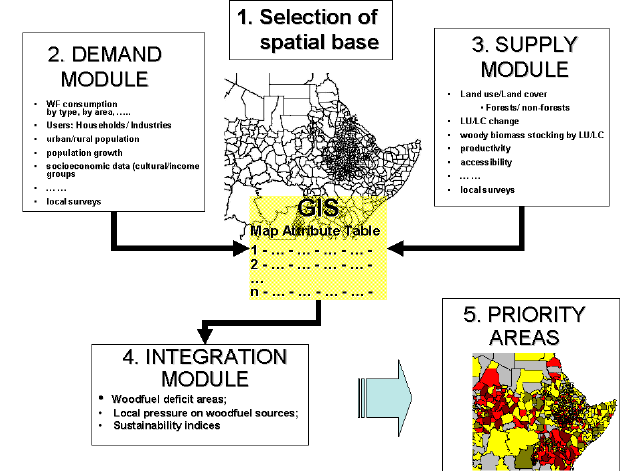
The use of WISDOM involves five main steps (See Figure 1):
1. Definition of the minimum administrative spatial unit of analysis.
2. Development of the DEMAND module.
3. Development of the SUPPLY module.
4. Development of the INTEGRATION module.
5. Selection of the PRIORITY areas or woodfuel hot spots.
Figure 1. WISDOM Steps
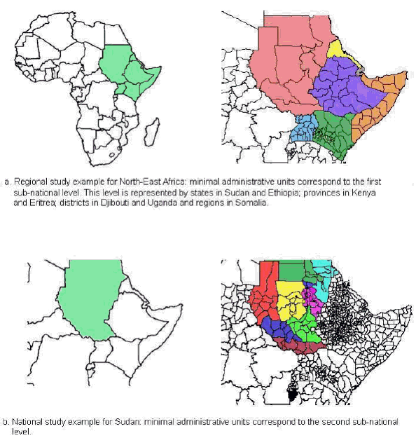
For national level studies the analysis would be carried out at the lowest administrative level for which demographic, social and economic parameters are available, e.g. municipality. At regional level, whereby a number of countries are studied, the sub-national administrative data set is still essential but a lower administrative level may be preferred. The first or second sub-national level may be appropriate, depending on the size of the countries involved, which could correspond to state, district or provincial level (Table 1). Figure 2 shows map examples of the minimal administrative units of analysis that should at least be considered in both regional and national WISDOM approaches.
Table 1. Information needs at different scales of analysis
Scale |
Regional WISDOM |
National WISDOM |
World |
X |
|
Region |
X |
|
Sub-region |
X |
|
Country |
X |
X |
1st level sub-national units (state, federal unit, ) |
X |
X |
2nd level sub-national units (district, province, ) |
(X) |
X |
3rd level sub-national units (county, municipality, ) |
(X) | |
4th level sub-national units (village, ) |
(X) | |
The sub-national administrative base map will determine the spatial resolution of the demand and supply module and, consequently, the WISDOM level of analysis and priority zoning. Many countries already have their administrative units in digital data sets, which facilitates the analysis. Censuses and other socio-economic information are also being increasingly provided in digital form, and in considerable detail. In Mexico for example, socio-demographic data at the municipal level is available on the internet.7
In the last few years, considerable progress has been made in the development of regional population density maps providing discrete population distribution originally derived from sub-national census data. The Global Population Database produced by the LandScan Global Population Project of Oak Ridge National Laboratory, which is a worldwide population database at 30 x 30 (arc second) resolution, is particularly interesting. If such a product is used as the basis for the development of the demand module, the spatial unit of reference will be the 30 x 30 cell or its aggregations. Case by case, WISDOM will have to adapt to the available information, the latter being either direct (woodfuel consumption and trends, sustainable woodfuel productivity) or indirect (proxy variables related to woodfuels demand and supply). Therefore, it is difficult to identify a fixed data set.
In this step, a tool for spatial representation and analysis needs to be put in place, as it is the key for the implementation of WISDOM. In fact, the possibility of linking statistical and spatial information is an essential feature of the whole process. The Geographic Information System (GIS) technology developed in the last few decades offers unprecedented possibilities to combine statistical and spatial information and to display the results of spatial analysis in easily understood ways to public officials and private citizens as well as to the scientific community (Marble, 1998). Because the GIS is an environment and land related technology, when used together with other databases and models it is a very useful tool in the formulation and implementation of sustainable development strategies (Yeh, 1997; Pakharel & Chandrashekar, 1997; Kersten et al, 1997).
Figure 2. Map examples of minimal administrative units (Northeast Africa (regional) and Sudan (national) examples)
The basic link between spatial and statistical data is done at the map attribute table level (Figure 1). This table, which has a database structure with rows and columns, contains the basic geographic attributes and identifiers of all individual elements of the digital map (identity codes and names, area, perimeter, coordinates, etc.), and can be expanded indefinitely by the addition of thematic attributes referring to the same set of map elements. Each row identifies a unique element of the map, such as an administrative unit or a settlement, while the columns report the geographic and thematic attributes associated to all of them. As an example of a map attribute table, Table 2 shows the first few records (rows) and fields (columns) of the digital map of Brazilian Municipalities (4579 units).
A salient feature of the WISDOM methodology is the progressive expansion of the map attribute table to include all the available information directly or indirectly related to woodfuel demand and supply (Steps 2 and 3).
Table 2. Example of a map attribute table
GIS attributes |
Thematic attributes (Demand, Supply and Integration modules) | ||||||||
ID # |
Area |
Perimeter |
ID_CODE |
Admin_NAME |
Theme 1 Census91 |
Theme 2 Census80 |
Theme 4 Forest2K |
Theme 5 Def902K |
Theme n .. |
1 |
13635896.5 |
28173.8 |
1400407 |
NORMANDIA |
11170 |
7713 |
0.86784 |
-0.07845 |
..... |
2 |
46755967.6 |
68430.2 |
1400100 |
BOA VISTA |
142813 |
51662 |
0.95823 |
-0.00840 |
..... |
3 |
23863175.3 |
31792.4 |
1600501 |
OIAPOQUE |
7543 |
5028 |
0.98250 |
-0.01750 |
..... |
4 |
15030224.0 |
29873.7 |
1600204 |
CALCOENE |
5185 |
2834 |
0.97482 |
-0.02518 |
..... |
5 |
27039699.2 |
38606.4 |
1400050 |
ALTO ALEGRE |
11195 |
3475 |
0.98127 |
-0.00879 |
..... |
6 |
15170360.4 |
20716.7 |
1400159 |
BONFIM |
9453 |
4524 |
0.94874 |
-0.01138 |
..... |
7 |
24876483.3 |
30872.8 |
1400308 |
MUCAJAI |
13148 |
3163 |
0.98695 |
-0.00985 |
..... |
8 |
76832247.1 |
60527.8 |
1500503 |
ALMEIRIM |
33270 |
33082 |
0.95450 |
-0.02209 |
..... |
9 |
113375415.0 |
71985.0 |
1505304 |
ORIXIMINA |
41089 |
29594 |
0.95539 |
-0.01800 |
..... |
n |
..... |
..... |
..... |
..... |
..... |
..... |
..... |
..... |
..... |
Modified from IBGE 1994
The Demand module is aimed at visualizing the spatial distribution of woodfuels consumption (if possible disaggregated by sectors and main types of users) and its overall dynamics. It also aims at identifying those areas showing distinctive consumption dynamics (e.g. increasing woodfuel needs). Several aspects specifically related to woodfuels need to be taken into account in the design of the module (Table 3).
We should stress that WISDOM is not a tool for predicting the evolution of woodfuel demand8; rather, it attempts to highlight those features of the woodfuel demand itself (or of their associated proxy variables) that are important in identifying priority areas later on. The main sources of information in developing this module are the statistics on demography and other socio-economic parameters collected and maintained by national statistical services, and technical studies and surveys with information on unit consumption by type of users and devices.
Table 3. General Characteristics of Woodfuel Demand in Developing Countries
|
Main sectors of users: households (rural and urban); Main uses: cooking, water heating, space heating, process heat for industrial users. Main types of woodfuels: fuelwood and charcoal; Main features of the consumption patterns: Rural users are
spatially scattered; normally consumption is highly resilient and
related to population growth. Woodfuels are mostly collected and come
from a variety of sources, including branches and dead wood. Other general issues: In general, a large proportion of woodfuels is extracted from non-commercial tree species, both from forests and trees outside forests. |
Several criteria can be set in order to determine priority areas in terms of woodfuel demand. For example, one might be interested in areas that show:
High woodfuel consumption.
High density of woodfuel users.
High growth rates of woodfuel consumption or users, either by households or industrial users.
High resistance to change to other fuels.
The precise criteria, and the corresponding prioritization of areas, will depend on the specific objective of the study. For example, one might be interested in identifying places with the potential larger market opportunities for new technologies, places where there are major health impacts, etc.
A number of variables can be used for the different criteria. For example, woodfuel consumption is a function of the total population, the percentage of woodfuel users and per capita (or unit) consumption; resilience of woodfuel use (defined here as the ability or willingness to switch to other fuels) is a function of household incomes and cultural practices, the latter usually related to cultural groups. Estimating users growth rates implies having historical series of the variables of interest; for example, at least two country censuses or national surveys. Table 4 shows potential variables that can be used in the analysis.
Whenever possible, it is important to assess the demand by woodfuel commodity (fuelwood, charcoal, black liquor, pyrolitic oil, etc.), since each one has a different impact on supply sources and supply sustainability, which call for separate lines of analysis. For example, fuelwood and charcoal, the two most common woodfuel commodities, come from sources which are at times quite distinct and exert very different impacts on such sources.
As shown in Table 4, the sources of the data are very different. A major challenge for the development of the module is to integrate consumption data coming from surveys ,usually covering only part of the country, regions, with socio-demographic variables coming from the census information.
Table 4. Potential Variables for use in the Demand Module
Variable/ issues |
Required breakdown |
Possible sources and remarks |
Woodfuel Consumption | ||
Households Woodfuel use per capita Number of users at time t |
By fuel type (fuelwood, charcoal, etc.). |
Estimates are available at national level, rarely
at sub-national level; often based on project level data. Estimates may
differ from source to source. |
Industrial users a Woodfuel use per unit of product |
By type (and size) of industries. |
Estimates usually based on project or survey level
data. |
Density of Users | ||
Saturation |
Urban/rural. |
National census and/or indirectly through surveys. |
Users by km2 |
Same as above. |
National census, could be assessed through GIS analysis. |
Growth Rates of consumption/users | ||
Users/Consumption Annual Average Growth Rates |
Urban/rural. |
UN population projections are available at national level only. Sub-national time series from national statistical services. Population growth maps (from LandScan) are expected to be developed shortly. |
Resistance to change to other fuels | ||
Relevant Cultural Groups |
Ethnic groups. |
National census. |
Income levels |
Income groups within urban/rural population. |
Income-Expense National Household surveys. |
Table 5 shows a brief description of the characteristics of woodfuel supply in developing countries. The WISDOM Supply module aims at a spatial representation of natural and man-made woodfuel sources, their stocking capacity, their change over time and their production capacities. Woodfuels are not produced or harvested exclusively from forests; rather, they are obtained from all land cover/land use types which imply the growth of woody biomass, e.g. farmland trees (RWEDP, 2000). In this respect, agricultural areas and marginal woodlands may be as important as forests in guaranteeing a steady supply of woodfuels to satisfy demand (RWEDP, 1996).10
Woodfuels can also be obtained directly from land areas (such as in the case of harvesting wood from forests or from trees outside forests) or can be a by-product of other activities (such as residues from forest industries or as recovered wood from construction/demolition activities) (RWDEP, 2000).
Table 5. General
Characteristics of Woodfuel Supply in Developing Countries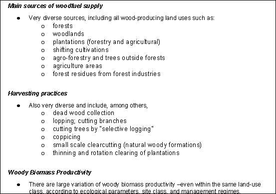
The analysis of woodfuel supply and the identification of priority areas can also be performed according to different criteria. If the analysis is directed to identify areas with potential current or future woodfuel shortages, then one might look at areas that show:
Rapid depletion rates of forests and woodlands due to land use changes;
Rapid degradation and fragmentation rates due to high pressure;
Low biomass productivity;
Accessibility aspects that limit the production (distance, slope, legal restrictions) or that, on the contrary, may favor overexploitation;
Alternatively, areas with the larger potential for woodfuel production will be those showing well preserved and accessible forests or other areas with high productivity.
Table 6 lists and briefly describes the main variables to be used for the development of the Supply Module.
Table 6. Potential Variables to be used in the Supply Module
Variable |
Required breakdown |
Possible sources and remarks |
|
Land Use/Land Cover (LU/LC) class |
All LU/LC classes must be considered, including croplands. |
Global maps are too coarse. High resolution maps with detailed classification systems should be preferred (e.g. FAO LCCS)11. |
|
Land use/Land cover change |
Crude deforestation rates should be avoided. Land cover transitions (i.e. using land use transition matrices) are better suited for this type of analysis. |
Consistent land cover change studies are rare. The most promising sources at the international level are FAO RSS12 and TREES II HRS13. |
|
Woody biomass stocking by LU/LC |
Biomass stocking for all LU/LC classes must be considered, including croplands, scrublands, etc. |
Biomass studies are rare. Inventory estimates (volumes of biomass) may be used to assess biomass values for reference LU/LC classes and infer all others. It is important to include estimates of total woody biomass as inventories are very often restricted to commercial biomass from forests. Estimates should also include dead biomass. |
|
Average Biomass Production by LU/LC class |
Productivity indices to be developed for all LU/LC classes, based on existing references. |
Accurate quantitative estimates are difficult to find. Yield data from inventories and ecological zoning will guide a productivity indexing. Potential sources include: AEZ, Soil Fertility Indices, and others. It is essential to include total (rather than commercial) woody biomass productivity. Estimates of dead wood productivity are also important. |
|
Accessibility |
Areas inaccessible for legal reasons (i.e. protected areas) and for physical reasons (slope, distance). |
National or global data sets (IUCN protected area maps, terrain models, e.g. GTOPO 30, DCW-derived products, etc.). |
In general terms, it may be assumed that the woodfuel supply capacity (WSC) at any given location (l) and at any given time (t), is a function of several factors:
WSClt = f [(Land Use/Land Cover, Biomass Productivity, Accessibility)lt ,Wf demand, ]
The quantitative WSC value is extremely difficult to determine accurately since it depends on the capacity (potential) of an area to produce biomass, which may vary significantly (ESMAP, 2001). Moreover, the majority of research in this field has concentrated on establishing the amounts of usable timber produced by commercial tree species (i.e. annual increment of stems), which is not of interest for the rural woodfuel supply (Kaale, 1990). On the other hand, estimating the woodfuel supply of non-forest areas is particularly complicated, again because of the high degree of variability in the woody cover and productivity of these areas. In many instances, the capacity of agricultural farming systems to produce woodfuels depends on the level of demand and accessibility of alternative sources, which might bring their production to a higher or lower priority level with respect to other products (Mahapatra & Mitchell, 1999).
Since the scope of WISDOM is not to quantify accurately the demand-supply balance but rather to help conduct a general assessment of the current situation and likely trends, the analysis of the supply module could include indicative biomass productivity indices based on climate/soil characteristics, and concentrate mainly on the analysis of Land Use/Land Cover (LU/LC) information and its derived spatial/statistical layers.
Having developed the demand and supply modules in the GIS system, the next step is to integrate the information, in order to subsequently identify the relevant woodfuels hot spots. At this stage, for each minimum administrative unit of analysis, a set of variables related to both woodfuel consumption and supply should already be in place.
Several variables (or indicators) can be designed for combining woodfuel supply and demand in order to have a better understanding of its potential impact. The selection of the indicators will be decided separately for each case, depending on the availability and accuracy of the data. Potential indicators include:
Woodfuel deficit areas = [ Wf supply Wf Demand ]
where, strictly speaking, deficit areas are those with negative values However, due to difficulty in obtaining accurate information on both supply and demand, different thresholds could be defined so that woodfuel deficit areas are actually units that show a range of values around zero.
Potential Pressure on Forests = [ Wf Demand / Total Forest Area]
This indicator is given in ton/ha/yr (or m3/ha/yr); therefore, it gives an idea of the average local forest productivity needed to cope with the existing woodfuel demand. If the demand is higher than the usual ranges for forest productivity in the area, then a large pressure on forest resources may be assumed. The analysis can also be refined to incorporate non-forest areas as well.
The final step is the identification of those areas where action is more urgently needed either in terms of issues related to demand or supply or both. Diverse multivariate statistical procedures could be used for the final grouping of the sub-national areas in terms of priority. These procedures include: a) data grouping techniques; b) factor analysis (e.g. principal components); c) cluster analysis; d) indexing, and others. We refer readers to the vast literature on these issues for a complete description of the approaches, their main comparative advantages and their shortcomings.14
An alternative procedure is the construction of an overall index (e.g. woodfuel priority index) (Masera et al, 2003) that reflects the key aspects of the areas of analysis in terms of both woodfuel demand and supply. A positive effect of indexing is the reduction of the inaccuracy derived from weak data sets. Such an index may be defined first for each of the variables:
Wfij = X
where X = 1, 2 n
and Wfij is the woodfuel index by unit of analysis i (e.g. a county) , according to a grouping of the variable j in a given number of categories n (for example, in terms of three levels of consumption: low, medium, high). The groups (values of the index) can be obtained by dividing the variable concerned into equal intervals or natural groups. Indexes can be discrete or continuous.
In order to highlight the spatial pattern of specific aspects, individual indexed demand/supply parameters may be combined, e.g. current consumption vs. accessible forest and woodland resources, urbanisation trends vs. natural wood resources change rates, etc. Then, an overall index for each spatial unit, reflecting the priority of the unit in terms of woodfuel consumption, production and impacts, can be defined as:
WFj = S ( Wfij* wij )
where:
WFj is the overall woodfuel index by spatial unit j, and
wij the priority given to each of the variables i.
Finally, the spatial units can be ranked according to the value of the overall index in a series of categories, from low to high priority, allowing the determination of the woodfuel hot spots.
After conducting the five steps, WISDOM should result in:
A geo-referenced database, disaggregated at the smallest administrative unit of analysis, containing information relevant to understanding the state and evolution of woodfuel demand and supply.
A set of maps covering the different aspects of woodfuel demand and supply.
A zoning of the country/regions according to its priority regarding woodfuel use and its associated or potential impacts.
7 Mexican National Bureau of Statistics
(INEGI),
http://www.inegi.gob.mx, SIMBAD
DataBase.
8
Several models have been used and tested for this purpose, both at the national and international level. See for example Broadhead et al. (2002) for a global model, and Devadas (2001)
and Díaz (2000) for national-level models.
9 Global Population
Database produced by the LandScan Global Population Project of Oak Ridge
National Laboratory, which is a worldwide population database at 30 x 30
(arc second) resolution.
10 An extensive study conducted by
the Regional Wood Energy Programme (RWEDP) in 8 countries within Asia showed
that the percentage of woodfuels coming from outside forests ranged from 87%
(for Bangladesh) to 34% (for Nepal) (RWEDP, 1996).
11 FAO Land Cover
Classification System (LCCS) developed in the framework of the AFRICOVER
Project.
12 Pan-tropical remote sensing survey
carried out under FRA 1990 and 2000, covering 10% of tropical regions over the
period 1980-1990-2000.
13 High resolution
survey of humid tropical forests carried out by JRC TREES II Project, covering
the period 1990-1997
14 For example, Hair, J.F. et al. (1992) provides a good description of the most common multivariate statistical analyses. Standard statistical texts usually provide a section on multivariate analysis. The web site : http://trochim.human.cornell.edu/tutorial/flynn/multivar.htm
provides a step by step tutorial on how to conduct a multivariate
analysis.