


Based on the work of Cyriaque Nzojibwami
Parks for Peace Project, National Institute for Nature
Conservation and the Environment, Burundi
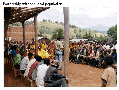
This national park contains Burundis only montane forest. Village communities participate in its management through a community conservation plan, which is a pledge of partnership among the people, the administration and conservationists. In addition, a new consultative body, the local park watchdog committee, set up in each of the communes around the park, appears to be a solution to the question of how to involve the people in managing the park. This management scheme is part of a process under which conservation is incorporated into the consolidation of peace in Burundi.
DESCRIPTION OF THE KIBIRA NATIONAL PARK
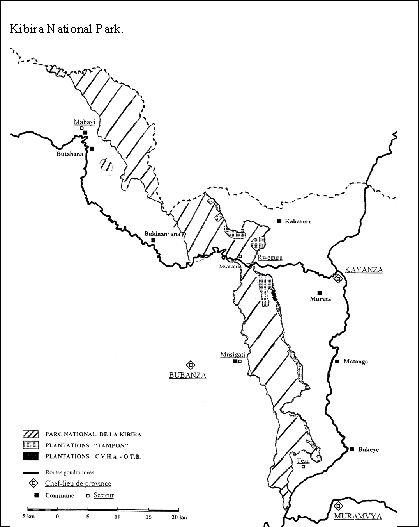
The Kibira National Park straddles four provinces in Burundi and has an area of 40 000 ha. It is composed of montane rain forest containing several vegetation strata: Entandrophragma excelsum and Parinari excelsa stands, Parinari excelsa var. holstii and Polyscias fulva stands, Polyscias fulva, Macaranga neomildreadiana and Syzygium parvifolium stands, Hagenia abyssinica and Faurea saligna secondary forest stands, Philippia benguelensis and Protea madiensis high-altitude stands on ridges, Arundinaria alpina (pure bamboo) stands, stands along thalwegs and stands formed by recolonization of previously cultivated and grazed land. It is a zone rich in both animal and plant biodiversity: 644 plant species have been found in the park, as well as about 98 species of mammal (primates, servals, African civets, etc.). Bird life is also rich and varied, with 43 families and more than 200 species identified.
More than three-quarters of the water in the countrys largest dam providing more than 50 percent of the hydroelectric energy consumed comes from this forest. Thus the park, situated as it is on the Congo-Nile ridge, plays a fundamental role in regulating the hydrological system and protecting against soil erosion.
THE BURUNDIAN POLITICAL CONTEXT AND THE VARIOUS STAKEHOLDERS
The Forest Code promulgated in 1985 (Law 1/02 of 25 March 1985) provides the basis for the various Burundian laws on forests, notably Law 1/010 of 30 June 2000 containing the environmental code for the country. The Kibira National Park was granted legal status in 2000 with Decree 100/007 of 25 January, establishing the park and four nature reserves.
The Kibira forest at present comes under the Ministry of Regional Development, the Environment and Tourism and the National Institute for Nature Conservation and the Environment (INECN). Management has led to the subdivision of the park into small management units, i.e. four sectors (one sector for each province) and 32 subsectors. It has a park supervisor and four sector heads, while each subsector has a forest warden and an assistant. Lastly, the INECN and the Parks for Peace Project have established watchdog committees elected by the people at various levels hills (the smallest administrative unit), sectors, zones and communes. The park supervisor supervises all activities in the park, the sector heads implement them in their respective zones, and the watchdog committees closely monitor the way the park is managed. Thus, the INECN, the local administration, the local population and the watchdog committees are the main actors in park management. Nearly 50 000 people from communes adjacent to the park are involved directly or indirectly in management of the park.
MANAGEMENT OF THE KIBIRA NATIONAL PARK
Until 1933, this forest was a hunting reserve of the Kings of Burundi. The local people respected the forest, investing it with a magical power. Rights of use for livestock grazing and the gathering of forest products were recognized. The sacred character of the forest, even prior to the colonial era, helped to conserve it. Between 1933 and 1980 Kibira was classified as the Congo-Nile Ridge Forest Reserve, first under Belgian rule, then after Burundian Independence in July 1962. Only the extraction of high-value timber (Entandrophragma excelsum and Prunus africana) was regulated and controlled. Between Independence and 1980, the right to allocate new land for cultivation within the defined boundary was abolished, although grazing rights were retained.
The Kibira management project dates from 1979, with the objectives of controlling the erosion of slopes, regulating river flows, and promoting ecotourism. At that time Burundi obtained funding from the Aid and Cooperation Fund and the Central Fund (now the French Development Fund). In 1979, 2 000 ha were used to establish planted forests in the park. Between 1980 and 1993 Kibira was officially designated a national park, and management was initiated in 1982, with zoning, development of tourist and educational paths, camping grounds and shelters, preparation of community conservation plans following participatory diagnosis, and establishment of local watchdog committees at various levels. The parks boundaries were redrawn between 1980 and 1985 and tracks opened within it. In 1993 the political crisis deteriorated into armed conflict. Some of the monitoring staff abandoned their jobs and some of the local inhabitants seized the opportunity to cut timber and clear some areas of the park.
The Kibira National Park management plan has been in existence since 1996. It goes into detail regarding the planted forests that act as buffer zones and the various silvicultural tasks to be carried out until 2023, and also sets out production norms and lists the types of forest product to be harvested. It provides a detailed map of plots for each planting season, a schedule of activities for each hill and plot, and a programme of clearing and harvesting for each year and plot.
A vegetation map was prepared by the SCETAGRI consulting firm from 1984 photographs, and this allowed a census to be made of plantations established prior to the parks creation. Researchers from the University of Burundi and other institutions have also worked on the vegetation of the park. Different activities were defined according to the particular characteristics of certain zones. Harvesting is carried out on 2 000 ha of plantation (Pinus, Cupressus, Grevillea and Eucalyptus). However, the main purpose of the park is ecotourism, as it is the only montane forest in Burundi. Twenty-five km of tourist trails have thus been opened up and developed on the steep slopes. Three camping areas have been prepared. Tourist activities help to raise the awareness of visitors regarding nature conservation. Scientific activities lead to long-term conservation of distinctive and endemic plant and/or animal wildlife.
Working with the INECN, the Parks for Peace Project is in the process of setting up a new type of consultative body, the local watchdog committee, in all the communes around the Kibira park. These committees are already up and running in two communes. The people themselves were worried by certain destructive practices being adopted in the park and asked to participate in denouncing these and in the seizure of products stolen from the park. The INECN and the Parks for Peace Project welcomed this initiative and asked the people to elect representatives, from hill to commune level. Establishment of these committees first entails a participatory diagnosis in which extension workers meet the people at hill level. The people of each hill then elect a committee of ten people, who in turn elect a committee of ten people per sector. These sector committees include both men and women and a representative of the Batwa (the indigenous people). Representatives from the various sectors then elect a committee of ten to represent the zone. A community plan of action is then drawn up on the basis of the five main constraints identified by the zone committees, which draw up a community conservation action plan for the park at commune level. This community conservation action plan is a pledge of partnership among the local people, the administration and conservationists, and is used as the basis for the activities of all those involved in conservation (NGOs, private sector or donors).
Some activities are permitted at park level within reasonable limits (gathering fuelwood and NWFPs). However, regulations seem to be needed to govern harvesting of the most widely used forest products, such as live wood and bamboo. Trees may not be felled in the park without the wardens authorization. In order to address the problem of fires caused in the process of honey gathering, beekeepers groups have carried out trials with a view to reconciling their needs and those of the park. Hunting has been forbidden in Kibira since 1980, but poaching persists.
The formation of ecological-type groups around the Kibira park is encouraged, and the people are starting to join forces to ask for support in improving their living conditions. The INECN and the Parks for Peace Project are sensitizing the various services working around the park so that they give special attention to the local population, for conservation of the park depends on improvement in their living conditions.
In consultation with the elected committees, a warning system has been developed and consideration given to a code of conduct that could be adopted around the Kibira park. A person or a group of people who becomes aware of a violation advises the watchdog committees, who in turn inform the local-level wardens, who can in turn inform the administration and the police to request assistance. The INECN is the centre for all information and finds solutions to the various violations. These decisions must be transmitted down to the lowest level, i.e. the local population. Those committing violations pay fines and the object of the violation is confiscated.
ASSESSMENT AND CONCLUSIONS
The first requirement for preparing the Kibira National Park management plan is a real national political will and also an international one. Kibira is one of the rare African forests located in a heavily populated region undergoing armed conflict. A return to peace is essential, and the international community has a role to play in resolving conflicts. In a country as overpopulated as Burundi, conservation also entails the consultation and empowerment of all actors.
Donors interventions do not always take account of the regional or cross-border character of natural resources. The Kibira National Park borders on the Nyungwe forest in Rwanda, and Rwandans cross into the park to clear land for agriculture or search for gold. The intervention strategies and activities of the various technical services involved in biodiversity conservation therefore need to be coordinated and harmonized at regional level. Similarly, an efficient regional-level coordination service for the management of protected areas is needed.
A system for the exchange of information between countries is also essential. A forest symposium is organized in Burundi every ten years. A programme is needed to improve and update information and knowledge for conservationists at all levels which would also allow the approaches of different countries to be harmonized. Local NGOs are themselves recent and not yet in a position to foster this type of initiative.
A management plan must respond to the ecological, economic and social concerns of the people living around the park. It has been recognized that sustainable forest resource management cannot succeed without the participation of the local population, and there is no such participation without dialogue and the sharing of information and experience. Identification of partners and good communications are preconditions for conserving the biodiversity of the Kibira National Park. Moreover, a management plan should not be static, but must be revised when necessary. At the park level, new boundaries should be fixed, the INECNs capacities strengthened to ensure park management, and current initiatives (for example the Parks for Peace Project) supported. Ecotourism infrastructures need rehabilitation. Inventories should be made of species of economic interest that are in danger of disappearing and of the plants most used in traditional medicine. It is also important to record all consumable and usable products and support the programme for the domestication of indigenous species. An inventory of wildlife and a study of its dynamics would also be helpful.
Supervision and monitoring must be carried out by park officers and rangers with at least a minimum of resources (which do not as yet exist). The other partners who could undertake monitoring are the local population through their elected committees. Setting up local watchdog committees thus seems the best way of involving the local population in management of the park.
BIBLIOGRAPHY
Biodiversity Support Program. 2001. La gestion transfrontalière des ressources naturelles en Afrique sub-sahélienne.
FAO. 1995. Participatory approach, communication and management of forest resources in Sahelian Africa: present situation and outlook. Rome.
INECN. 1992. Plan global pour le programme récréatif et de linterprétation. Gitega.
INECN. 2000. Vingt ans dexistence de lINECN 1980-2000. Gitega.
MATET. 2001. Convention cadre des Nations Unies sur les changements climatiques. First national communication. Bujumbura.
MATET/PNUD. 1999. Stratégie nationale et plan daction en matière de diversité biologique: analyse de la diversité biologique végétale nationale et identification des priorités de sa conservation. Bujumbura.
Michel, A. 1992. Parc national de la Kibira, état des réalisations. INECN, Caisse française de développement, Gitega.
Michel, A. 1996. Parc national de la Kibira. Plan de gestion de la Kibira, descriptif. Gitega.
Ministry of the interior. 1990. Résultats provisoires. Recensement général de la population et de lhabitation. Bujumbura.
Nindorera, D. 2000. Etude sur la gestion des conflits au parc national de la Kibira. IUCN/ INECN, Gitega.
Nzigidahera, N. & Misigaro, M. 2002. Plan communautaire de conservation du parc national de la Kibira en commune Muramvya. INECN, Gitega.
Based on the work of Paulino Bololo Ekobo
Equatorial Guinea Institution
Management of the Luba Crater Scientific Reserve helps to ensure the conservation of its remarkable biological wealth, encompassing ecosystems and habitats unique in Equatorial Guinea. The management system described in this example was established in 1995 by an NGO and entails a biodiversity conservation programme focusing on protection of the green turtle.
DESCRIPTION OF THE LUBA CRATER SCIENTIFIC RESERVE
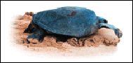
The Luba Crater Scientific Reserve has an area of 51 000 ha and is located on Bioko Island in Equatorial Guineas Bioko Sur Province. The main forms of vegetation are low- and medium-altitude closed rain forest (up to 700 m) with great specific diversity, montane forest (between 700 and 2 000 m) with an abundance of creepers and epiphytes, high-altitude Araliaceae forest, Aricaceae forest and secondary formations. Its position on an island makes this reserve a refuge for many species of terrestrial and aquatic wildlife. The zone has a great density of primates, some of them endemic, and also shelters one of the last remaining populations of drills. Green turtles can be observed in the beach areas. The Luba crater has striking landscapes, with waterfalls, black sand beaches, etc.
THE CONTEXT OF NATURAL RESOURCE CONSERVATION IN EQUATORIAL GUINEA
Various laws have been promulgated in Equatorial Guinea to ensure the conservation of forest resources. For example, Law 8/1988 of 31 December 1988 lays down regulations for forest wildlife and protected areas, while Law 1/1997 of 18 February 1997 deals with the use and rational management of forests, establishing two forest categories: protected forests (a system of protected areas) and production forests intended for the sustainable production of forest products. The latter law also specifies a maximum production volume in order to ensure sustainability, as well as setting up the National Institute for Forest Development as an autonomous organization responsible for sustainable forest development. Statutory Order 6/1990 of 22 August 1990 established the National Committee for Environmental Protection, which has the primary task of applying the resolutions of the Conference of Heads of State on the Environment and the United Nations Convention, as well as other conventions signed by Equatorial Guinea on similar subjects. Law 4/2000 of 22 May 2000 deals with protected areas and is intended to create a national system of 13 such areas, covering a total of 586 000 ha. It distinguishes four categories of protected area: scientific reserves, national parks, natural monuments and nature reserves. It also establishes the National Institute for Protected Areas as an autonomous structure for the management of the national system and guarantees the participation of the local population in the management of these areas.
Protected areas come under the Ministry of Forests, Fisheries and the Environment, which is also responsible for forest resources throughout the country. The General Directorate of Forests is responsible for implementing forest development policies and strategies, working in collaboration with the National Committee for Environmental Protection, the various ministerial departments involved in forest resource management, national and international scientific institutions, and bilateral and multilateral organizations. NGOs also play a considerable role.
A conservation and ecodevelopment programme was started in the El Sur Protected Area on Bioko Island in 1995, thanks to a Spanish NGO, the Asociación Amigos de Doñana (AAD). An initial analysis of the various areas covered by Law 8/1988 was carried out by the Forest Planning Bureau of the Ministry of Forests, Fisheries and the Environment in 1996. In 1997, the Conservation and Rational Use of the Forest Systems of Equatorial Guinea Project revised and expanded on earlier studies with new field information and the interpretation of remote sensing images. This resulted in a detailed analysis of areas considered critical for the conservation of biological diversity, the maintenance of ecological resources and a rational and sustainable approach to forest species and forest ecosystems, including those found in the Luba crater zone.
However, only two protected areas in the national system have received any real attention with regard to protection, conservation and management. These are the Monte Alén National Park (under the ECOFAC Programme), established in 1996, and the Luba Crater Scientific Reserve. AAD is responsible for conservation, education and awareness-building for the latter. The great biological wealth of the Luba crater has made it the subject of many studies by a variety of institutions. In particular, the National University of Equatorial Guinea and Arcadia University in the United States have been carrying out a joint research programme on primate populations since 1996.
The Luba Crater Scientific Reserve affects 7 200 people within its borders and in adjacent villages. The main activity of the local population is agriculture, using traditional methods and intended mainly for household consumption. There are also cocoa plantations.
MANAGEMENT OF THE LUBA CRATER SCIENTIFIC RESERVE
The management of protected areas is a new activity in Equatorial Guinea. However, studies have been carried out since the 1980s, especially by the Spanish aid organization and IUCN, with a view to identifying areas that should be declared protected, and these areas included the Luba crater because of its great biological wealth. The area was accordingly included in Law 8/1988 as a protected area. The main objective of management of the reserve is to ensure the conservation of its exceptional biological wealth, with ecosystems and habitats unique in Equatorial Guinea. In 1995, AAD launched a conservation programme focusing on a series of studies of species of exceptional biological interest, especially animals, implementation of an ecotourism programme, domestication of forest animals and environmental education. In 1997 the NGO submitted a management plan for the area to the forest administration for discussion. After this it carried out activities under its initial programme and sought to set up awareness programmes on the conservation of turtles and to build facilities for tourist development. However, its activities were suspended in 1998.
Law 4/2000 requires the preparation of a master plan for each protected area, to serve as a technical and administrative tool in specifying activities and associated protection measures. The law calls for the establishment of a managing committee to ensure the participation of the local population in the management of protected areas. Although AAD submitted a provisional working plan for the reserve to the administration in 1997, the master plan required by law still does not exist. No management plan has yet been implemented in Equatorial Guinea, apart from that for the Monte Alén National Park. However, a provisional management plan for each protected area has been prepared as part of the Conservation and Rational Use of the Forest Systems of Equatorial Guinea Project. This is the only technical document available for the management of protected areas and includes a diagnosis of each zone (state of conservation, problems noted and level of knowledge). Management covers objectives, zoning, infrastructures, anticipated activities, studies and planning. The diagnosis of the Luba Crater Scientific Reserve indicates a good state of conservation and describes all the activities and practices pursued in the zone.
Apart from ensuring conservation of the areas exceptional biological wealth, the objectives of the working plan include a ban on building access roads to the reserve from anywhere along the coast, a reduction in pressure from housing or indeed its elimination throughout the reserve, encouragement of the rehabilitation of agricultural zones, detailed demarcation of the traditional zone assigned to the local population, establishment of ecotourism facilities compatible with conservation of the area and facilitation of collaboration with any scientific expedition. Zoning has allowed definition of a traditional zone for the people, a special zone for tourist facilities, an open zone with trekking trails and a restricted zone covering the rest of the reserve.
The plan anticipates an agreement with AAD, under which management plans and any revision must be approved by the authority responsible for protected areas, while the NGO has autonomy in carrying out work within the reserve. The NGO has built premises to provide an institutional presence, coordinate activities, receive visitors, etc. Activities so far have focused on identification and elimination of house-building, patrols, re-establishment of tourist trails, promotion of scientific research, establishment of good relations with the local people and study of how they can participate in ecotourism, etc. Research includes study of the local population and sacred sites.
ASSESSMENT AND CONCLUSIONS
In recent years there have been some important events fostering the rational use, protection and conservation of natural resources in Equatorial Guinea, such as Law 4/2000, creating a national system of protected areas and establishing various categories of protected area. Apart from the Monte Alén National Park, the Luba Crater Scientific Reserve is the only one that has been the object of conservation activities. Since 1995, AAD has implemented a very broad programme of biodiversity conservation, centred on the protection of green turtles. However, the absence of an institution with responsibility for managing the reserve has prevented proper use of the infrastructures already established and effective coordination of the activities of the various groups and institutions active in the zone. On the contrary, activities running counter to the aims of the protected area have taken place (such as turtle catching).
The many studies carried out in the zone have led to fuller knowledge about it and its great biological wealth. However, all this information is scattered among various institutions, so that access is not easy although the centres and office that have been built should facilitate such access.
If the status of the Luba Crater Scientific Reserve is to be improved, the National Institute for Forest Development, which is responsible for the management of protected areas, must be got up and running. The agreement with AAD should also be re-established, or a new agreement made with another NGO with experience of management and the preparation of a master plan in the zone although the National Institute for Forest Development would retain the right of control and supervision of the NGOs activities. A special control and monitoring body should also be set up.
BIBLIOGRAPHY
CUREF/SAUC.37. 1999. Líneas directrices para la gestión del sistema nacional de areas protegidas.
Castroviejo, J. 1994. Estudio sobre la zonificación y usos múltiples de les areas protegidas de la Isla de Bioko.
Forest planning Cabinet. 2000. Legislación forestal.
Gail, W., Wayne, A., et al. 2001. La inminente extinción de los monos y antílopes de la Isla de Bioko, Guinea Ecuatorial, Africa.
Ministry of forests, fisheries and the environment. 2000. Programa nacional de acción forestal.
Nsue, E.E. 2001. Estudio sobre la necesidad de conservar las 7 especies de primates del Sur de la Isla de Bioko.
Onva, M.V. 2001. Estudio sobre las tortugas marinas en el sur de Bioko.
Based on the work of Norbert Gami
FTRP, the Congo

This pilot experiment in joint sustainable management of the gorilla resource brings together conservation and the local populations participation in management of this gorilla sanctuary. The advantage of a multidisciplinary approach to the sustainable development of a forest zone in Central Africa is described in this example, especially the anthropological approach in establishing and maintaining partnerships among the various stakeholders. The experiment, so far unique in the subregion, deserves encouragement and should be adapted to other similar contexts.
DESCRIPTION OF THE LOSSI GORILLA SANCTUARY
The Lossi Gorilla Sanctuary covers 35 000 ha on the edge of the Odzala-Kokoua National Park in the West Cuvette administrative region of Mbomo District in the northwest of the Republic of the Congo. The vegetation consists of a mosaic of closed semi-deciduous forest (7 percent of the total area), sparse Marantaceae forest on dry land (66 percent), with secondary vegetation on the sites of former villages, while swamp forest accounts for 26 percent of the total area, shrub savannah 0.6 percent and thickets 0.2 percent.
Besides gorillas and chimpanzees, which are the reason for the sanctuarys creation, the zone is rich in other wildlife (elephants, duikers, buffalo, etc.). Lossi offers exceptional conditions with very little pressure on gorilla and chimpanzee populations from hunting, a high density of gorilla groups and periodically flooded forest and other swamp zones, which makes it easier to monitor these groups.
THE CONGOLESE CONTEXT AND THE VARIOUS STAKEHOLDERS
The creation of the Lossi Gorilla Sanctuary by the local people had the advantage of a legal context favourable to this type of initiative. At that time, the Congolese Forest Code (Law 16/2000 of 20 November 2000) was being overhauled in order to take account of the various factors involved in sustainable participatory management of forests. The sanctuary falls into the category of special reserves with the aim of protecting typical animal communities (in this case Gorilla gorilla gorilla) and the biotopes essential for their survival.
The forest is officially managed by the Ministry of Forest Economy in charge of Fishing and Fishery Resources through the Warden of the Odzala-Kokoua National Park, who is appointed by the Directorate of Forests and Protected Areas. The warden handles relations with the various administrative offices and oversees the good running of the forest. At field level, the ECOFAC Programme, with funding from the EU, supports research on habituating gorillas to a human presence and on the involvement of the local population. The ECOFAC Programme has been working in six protected areas in Central Africa since 1992 to promote sustainable ecosystem management and has been developing a participatory approach (or co-management) involving the various stakeholders. The EU programme The Future of Tropical Rainforest Peoples (FTRP) has also contributed to the process of effective joint management of the sanctuary through the mediation of an anthropologist. ECOFAC is currently meeting the cost of the wages of the sanctuarys guides and trackers and suggesting improvements to the sanctuary.
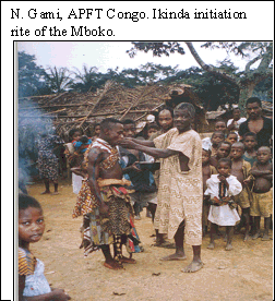
The local people, especially those who had rights to the Lossi lands and who gave up their land for conservation, have formed a Lossi Land Rights-holders Association, which will be represented on the board of directors in order to take part in any decisions regarding management of the sanctuary. At present the association controls access to the sanctuary for gathering and seasonal fishing and is responsible for management of the tourist site and upkeep of the access track. There is no active NGO in the zone with which the association could work. Three villages, Lengui-lengui, Ombo and Mouangui, are at present affected by the Lossi Gorilla Sanctuary.
THE EXPERIENCE OF THE LOSSI GORILLA SANCTUARY
An experiment on the habituation of lowland gorillas to the presence of humans has been taking place in the Lossi forest since 1992, and two groups of gorillas have become accustomed to the presence of humans through the work of two primatologists. This was the local populations main reason for creating a sanctuary whose primary purpose is game-viewing tourism. The people sent a letter to the Minister of Forest Economy explaining why they wanted this forest zone to be declared a reserve. EFOFAC requested the FTRP programme to carry out an anthropological feasibility study for such a sanctuary. This study permitted both identification of the lineages and families with land there and also their organization into associations. It also helped in finalizing the statutes and internal regulations of the sanctuary and the association and in formalizing agreements. This framework then made it possible to advise the local people on setting up community activities. The feasibility study indicated that they needed to harvest certain forest resources, especially NWFPs, seasonally.
The official decree establishing the gorilla sanctuary was signed by the Congolese Government on 10 May 2001. It clearly shows the authorities desire to implement natural resource co-management with the local people. The decree confirms the boundaries of the protected area according to the wishes of rights-holders in the Lossi lands, taking into account their need to harvest natural resources and also the concerns of primatologists, the ECOFAC Programme and the Ministry of Forest Economy regarding biodiversity conservation in the area, especially focusing on gorillas (a fully protected species in the Congo). Management of the sanctuary had begun in 1994, however, in order to promote game-viewing tourism and recreation, with the following features:
action to make a habituation zone for the gorillas secure and to raise the awareness of the local population regarding the importance of biodiversity and the need to conserve it;
creation of alternative activities to hunting for the people living in the zone;
research on gorilla groups and regular censuses of gorillas;
involvement of the village community in management and the sharing of benefits from tourism activities.
This pilot experiment is notable first for the fact that rights-holders decided to give up their ancestral lands to create the sanctuary and then for their involvement in managing the gorilla sanctuary in order to reap the financial benefits generated by ecotourism income that is then used for community initiatives. Those with customary rights over Lossi lands were identified in 1996. The boundaries to the zone were fixed in the same year by the local people with the supervision of the FTRP anthropologist and support from primatologists and the head of the ECOFAC-Congo component. The participatory mapping technique allowed rights-holders to define the zone to be declared a sanctuary, while keeping a large zone for subsistence activities.
The management master plan for the sanctuary was prepared in 2000, with the aims of assessing the various resources, the extent of the various forms of local use of forest resources, the impact of such use on the resources, the constraints on development that the sanctuary would face, and the potential impact of harvesting of the peripheral forest area on resources within the sanctuary.
An inventory of plant and animal wildlife resources and a survey of human activities were then carried out. A new computer tool, the cybertracker, was used to collect and analyse inventory data. This system uses a pocket computer (or palm pilot) linked to a global positioning system to collect data in the field and an automatic data transfer system to transfer data from the pocket computer to the databank on a desktop computer. The cybertracker allows mapping and the export of data in Excel format, either for statistical analysis or to represent them in a more powerful geographical information system. Indices of wildlife abundance, human activity and trees with fruit, commercial or medicinal value were obtained through this work. Thus, areas of activity by the local population within the sanctuary were mapped so that the various stakeholders can reflect better on the management techniques to be adopted.
Management and operational proposals were made in the management plan: registration at the Lossi Land Rights-holders Association office and the base camp of rights-holders carrying out activities in the sanctuary, questioning and expulsion of anyone found in the sanctuary with a weapon or illegal merchandise, setting of calendars of extraction and rotations for fishing areas and gathering areas. Certain conservation measures are anticipated, such as the creation of a buffer zone on the borders of the sanctuary. Furthermore, all rights of use within the sanctuary are suppressed, although exemptions are granted to Lossi land rights-holders for certain uses that have no negative impact on the gorillas. No authorization for logging, mining or agriculture may be granted within the sanctuary. The association is responsible for sensitizing other local inhabitants and for the prevention of poaching.
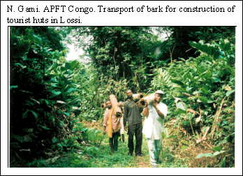
The association has built two tourist cabins and a restaurant for tourists. It is in charge of managing the tourist site and receives the income from this activity. The village community in the wider sense maintains part of the access track to the sanctuary, and this work is a condition for being chosen as a member of the porterage group that carries tourists luggage from the village to the sanctuary. Five local trackers have been trained, and two of them are now helping others in Gabon to learn from their experience.
Patrolling of the sanctuary is a major concern for the various partners. The management master plan stipulates two teams posted at the two main entrances to the sanctuary, two or three roving teams and an officer in charge of anti-poaching measures.
In 2000, the association mobilized the inhabitants of the three nearby villages to take part in carrying water and making bricks to build a dispensary. A health worker has been trained with support from the ECOFAC Programme.
ASSESSMENT AND CONCLUSIONS
The model of the Lossi Gorilla Sanctuary is interesting inasmuch as it combines conservation and the participation of the local population. It was established thanks to a forest legislation and a political will aimed at encouraging the local populations involvement in sustainable forest resource management. The strong motivation of the forest population should be stressed, and also the dialogue and mutual understanding among the various stakeholders. Another factor in the success of the programme is the location of the sanctuary far from cultivated village land so that it does not impinge on agricultural and hunting territory. Furthermore, there is a visible gorilla product that the local people can see and that can be marketed to tourists, and a slogan has been invented: A live animal brings in more than a dead one.
The continuing presence of an anthropologist in the field has allowed a better understanding of the various conflicts of interest. At present, the Lossi Land Rights-holders Association itself handles certain conflicts. The anthropological feasibility study identified the target group, i.e. the true landowners or those holding rights over the land on which the sanctuary has been established.
If forest management is to be profitable to all stakeholders, the start-up team must include the main interested parties, as must the consultation framework. A facilitator is needed to coordinate the various parties activities. There must be a written management agreement clearly defining not only the rights and duties of each party, but also the procedures for dividing the benefits generated by the jointly managed resource. Representatives of the village community must take part in the meetings held to close off the protected area. The political and administrative authorities must be brought to sign and publish a decree creating the conservation zone so that it is properly formalized. This legal basis will then allow stakeholders to defend their rights in case of litigation over any illegal use of the zone by a third party.
Certain elements can be adapted and applied to other conservation forests:
training of young trackers and guides from the locality;
long-term engagement of a facilitator familiar with the sociocultural context to train the local community and facilitate relations among the various parties;
establishment of a village association capable of representing the community in dealings with the other stakeholders;
identification of an economically viable tourist product to be developed, so that the local people feel involved;
presence of an international NGO, programme or project that will provide technical and financial support in the early stages of the initiative;
demarcation of the zone to be exploited with the people concerned in order to avoid subsequent conflicts over the use of resources and the goals of conservation;
establishment of a framework for consultation and coordination among the various stakeholders for management of the zone, development of community initiatives and resolution of conflicts.
However, the Lossi Land Rights-holders Association is not yet able to stand on its own feet and still needs technical and financial support from the ECOFAC Programme. There is little exchange of experience between the association and other projects in the country or associations working in the subregion. There is an urgent need to set up a coordination and management committee. The conclusion of a management agreement between the association and the other stakeholders is also vital. It is equally important that the other parties be willing to help the association to become independent and especially to seek supplementary funding.
BIBLIOGRAPHY
Bahuchet, S. 1997. Un style de vie en voie de mutation: considérations sur les peuples des forêts denses humides. In E. Guyot s.a. Civilisations, Vol. XLIV -1-2: p. 16-31. Les peuples des forêts tropicales. Bruxelles.
Bermejo, M. & Ilera, G. 1995. Programme de conservation, éducation environnementale et recherche scientifique de gorilles et chimpanzés de Lossi (Nord-Congo). Report of the first and second phase, AGRECO- GEI.
Bermejo, M. 1997. Expérience pilote de conservation communautaire du sanctuaire de gorilles de Lossi. AGRECO G.E.I.E. - BDPA-SCETAGRI - SECA - CIRAD Forêt in association with Fauna & Flaura International, ECOFAC report, Composante Congo.
Birraux-Ziegle, P. 1997. Culture, nature, nationalisme et internationalisme: lexemple des Yanomami et des peuples du bassin amazonien. In E. Guyot s.a. Civilisations, Vol. XLIV -1-2: p. 126-137. Les peuples des forêts tropicales. Bruxelles.
Borrini-Feyerabend, G. 1997. Gestion participative des aires protégées: ladaptation au contexte. IUCN, Gland, Switzerland et Cambridge, Royaume-Uni., United Kingdom
CAMPFIRE. 1997. Vivre avec la faune: comment les communautés CAMPFIRE conservent leurs ressources naturelles. Campfire fact sheet.
CANOPEE. 1999. LAfrique centrale et le tourisme de nature. Bulletin sur lenvironnement en Afrique Centrale, ECOFAC (Cellule de Coordination - Libreville).
Djombo, H. 1997. Discours de politique générale sur la relance des activités du secteur forestier au Congo-Brazzaville. Canopée, 10: 12-13.
Gami, N. 1996. Vérification de constitution dun secteur forestier villageois pouvant être géré avec laide de ladministration chargée de la faune et de la flore, par les populations exerçant un droit dusage sur les terres de la Lossi et de Lengui-Lengui dans la Sous-préfecture de Mbomo (Tourisme de vision de gorilles). ECOFAC, Brazzaville, Congo.
Gami, N. 1998. Rapport de la troisième mission (du 01 mars au 17 mars 1998) à Lengui-lengui, Mbomo et Lossi. AGRECO.
Gami, N. 1998. Rapport de mission sur la relance des activités de la composante ECOFAC-Congo et du sanctuaire de gorilles de Lossi (du 13 au 23 juin 98). AGRECO.
Gami, N. 1998. Rapport de mission spéciale Kéllé du 29 septembre au 10 octobre. AGRECO.
Gami, N. 1999. Rapport de mission: début du processus de classement (du 9 au 30 janvier 1999). AGRECO.
Gami, N. 1999. Rapport intermédiaire 1: encadrement et extension du PNO (du 16 mars au 03 avril). AGRECO.
Gami, N. 1999. Rapport intermédiaire 2: encadrement et extension du PNO (du 27 avril au 01 juin). AGRECO.
Gami, N. 1999. Rapport intermédiaire 3: encadrement et extension du PNO (du 12 juin au 17 juillet). AGRECO.
Gami, N. 1999. Rapport intermédiaire 4: encadrement et extension du PNO (du 25 septembre au 30 octobre). AGRECO.
Gami, N. 1999. Rapport intermédiaire 5: encadrement et extension du PNO (du 26 novembre au 12 décembre). AGRECO.
Joiris Daou, V. 1996. Importance des terroirs coutumiers pour la conservation: réflexion à partir du programme ECOFAC au Cameroun, au Gabon, au Congo et en République centrafricaine. Panafrican seminar on community management of natural resources and sustainable development. Harare, Zimbabwe, 24-27 June 1996.
Lanjouw, A. 1998. Programme international de conservation des Gorilles (PICG): résumé des activités du PICG pays par pays (RDC, Rwanda, Ounganda). Nouvelles sur la conservation des gorilles/Gorilla conservation newsletter, 12: 15-17.
Melissa J. Remis. 1998. Recherche sur les gorilles en République centrafricaine et résultats préliminaires sur limpact des activités humaines sur les gorilles (Gorilla gorilla gorilla) dans la réserve de Dzanga-Sangha. Nouvelles sur la conservation des gorilles/ Gorilla conservation newsletter, 12: 7-8.
Mampouya, A., 2000. Etude du terroir villageois à la périphérie du sanctuaire de gorilles de Lossi, Congo. Marien NGouabi University, Brazzaville.
Nguinguiri, J.C. 1997. Les approches participatives dans la gestion des écosystèmes forestiers dAfrique centrale - revue des initiatives existantes. Pointe-Noire, Congo-Brazzaville, Draft final report, FORAFRI et réseau Forêt de la CORAF.
Posey Darell, A. 1995. Indigenous peoples and traditional resource rights: a basis for equitable relationships? Oxford, Green College Centre for Environmental Policy & Understanding.
Schaffner, R. 2000. Plan directeur daménagement du sanctuaire de gorilles de Lossi, Congo. Louis Pasteur University, Strasbourg, France.