![]()
![]()
![]()
The median ridges of the Indian Ocean form three branches diverging from the area of the Rodriguez Island north-westwards (the Northwest Indian Ocean Ridge), south-westwards (the Southwest Indian Ridge) and south-eastwards (South-Eastern Ridge). The first two branches are typical mid-oceanic ridges and the last is a lower, wide mid-oceanic ridge, resembling a huge swell. The whole system of the ridges is generally described as the Mid-Indian Ocean Ridge. Figure 1 provides a bathymetric illustration of the study area.
Figure 1: Bathymetric map of the Southern Indian Ocean
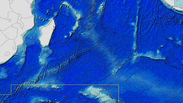
Credit: D. Barratt, Fisheries and Marine Sciences Program, Bureau of Rural Sciences, Department of Agriculture, Fisheries and Forestry – Australia
Red lines indicate boundaries of exclusive economic zones. The yellow line indicates the boundary of the Commission for the Conservation of Antarctic Marine Living Resources (CCAMLR) convention area.
Each branch of the Middle Indian Ocean Ridge divides into two parts: the north-western ridge into the Middle Aden Gulf Ridge and the Arabian-Indian Ridge; the south-western ridge into the Southwest Indian and the African - Antarctic Ridges. The south-eastern ridge divides into the Mid-Indian Ridge and the Australian - Antarctic Elevation. The border between two parts of each branch is the Owen Fracture Zone, Prince Edward Island and Amsterdam and Saint-Paul Islands (Kanaev, Neyman and Parin 1975). The principal scheme of the underwater ridges in the southern Indian Ocean is shown in Figures 2 and 3.
The Southwest Indian Ocean Ridge extends from the Central Massive south-westwards conjugating with the Mid-Atlantic Ridge. In the area of the Prince Edward Islands this branch is divided into two ridges: the Southwest-Indian and African-Antarctic Ridges. The latter ends in the Atlantic Ocean in close proximity to Bouvet Island. Madagascar Ridge is located southwards from the Madagascar. Breaks and seamounts are characteristic of the Southwest Indian and Madagascar Ridges and are found even at the bottom of the basins.
The Southeastern Mid-Ocean Ridge is represented by the Mid-Indian Ridge and Australian-Antarctic Elevation. The greater part of the ridge belongs to the Australian-Antarctic Elevation. The border between them is the south-eastern foot of the mountain system Amsterdam.
The Southwest Indian Ridge is a large underwater mountain system with highly cut terrain extending 1200 miles from the area of the Rodriguez Island to the Prince Edward Islands. It varies in from 200 to 300 miles in width (Shcherbachev, Kotlyar and Abramov 1989). The relative height of the base of the north-western part of the Ridge is 2 500 - 3 000 m and in the south-western part, 4 000 - 3 000 m over the bottom of the Agulhas and Mozambique Basins. Over the entire region, the relative elevation varies between 500 and 2 000 m over the bottom of the narrow gully extending between the middle ridge and the foot of the Prince Edward and Crozet Islands. The ridge depth varies from 1 000 to 4 000 m reaching a maximum height of 5 300 m on the 37 °S parallel (Kanaev, Neyman and Parin 1975). The minimum depths over the peaks of seamounts, found between 32 and 42 °S, are 102, 150, 250, 422, 690 and 710 m, etc. The slopes of the mounts are steep and rocky and the bottom sediments on the ridges are patchy in distribution. The principal sediments are foraminiferous ooze. The thickness of the sediments increases along the ridge from the north-east to the south-west in connection with the increased deposition of sediments due to the higher biological productivity of the Antarctic waters. However, in the axis part of the ridge, including the bottom of the rift canyons, sediments are generally absent.
The structure of the active layer of waters over the ridge is represented by the transitional zone of the interaction of two surface waters, the southern tropical and subtropical water masses. The southern tropical water mass lies northwards of region of the 30 - 32 °S parallels from the surface down to 500 - 600 m. Its distinctive temperature fluctuation are in the range 16 - 27 °C and salinity fluctuations are in the range of 34.8 - 35.3‰. The surface southern subtropical water mass is located between the 30 °S parallel and the Sub-antarctic front (located around 45 - 50°S). It is characterized by a temperature range of 17 - 24 °C and salinity range of 35.4 - 35.8‰. This water mass also has a subsurface structure with 12 - 17 °C temperature zones, a salinity of 35.0 - 35.5‰ and is separated from the surface water with layers of increasing vertical gradients of the oceanographic parameters. These three water structures have, in different seasons, from three to eight modifications when mixing with each other and intermediary Antarctic water mass. A particularly great variety of mixes of surface, subsurface and intermediary mater masses are distinguished at seamounts of the Western Indian Ridge (Seamounts 150, 251, 415 and 102) due to the specific oceanographic conditions (upwelling, oceanographic gyres, etc.) generated in the regions of these seamounts. The intermediary Sub-antarctic water mass in the area of the ridge is positioned in the layer deeper than 800 m. Its distinctive temperature range is 3 - 5 °C and salinity range of 34.3 - 34.6‰. In the area of seamounts this water mass may be found in depth range of 500 - 600 m (Burlenko 2001) due to local upwelling recorded at the seamounts.
Figure 2: Principal underwater features and seamounts at the Madagascar Ridge, Southwest Indian Ridge and Mid-Indian Ridge (northwest part) - FAO Area 51
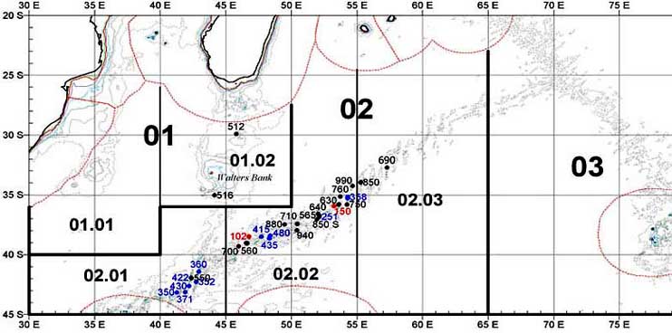
Proposed sub-areas for fisheries statistics purposes are also presented.
Figure 3: Principal underwater features and seamounts at Mid-Indian Ridge (southeast part), Ninety East Ridge and Broken Ridge - FAO Area 57
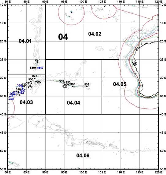
Proposed sub-areas for fisheries statistics purposes are presented also.
The Madagascar Ridge consists of a massive elevation of the bottom, extending between the micro-continent of Madagascar Island and the Western Indian Ridge for a distance of almost 700 miles. The ridge crest is wide and has depths from 1 000 to 2 500 m (at the positions of seamounts up to 567 m). The minimum depth falls on the Walters shoals (15 m). The shoals are cone-shaped with flat tops, its base is defines by the 800 m isobath. The flat top is covered by coral reefs with a broken and jagged relief, especially along the outer edges. The slopes of the shoal are steep; the angle of the incline ranges from 6 - 12 °. The sediments consist of foraminiferous ooze enriched with sand along the crests (Kanaev, Neyman and Parin 1975). The tops of other mounts rising over the ridge are located in depths from 84 m down to 567 m and deeper. In the southern part of the ridge between 31 and 35 °S parallels, depths of 900 - 1 100 m predominant. The ridge down to a depth of 1 500 m has mainly a flattened relief with the predominance of sloping-wave and stepped valleys. On the surface of these valleys hollows occur with amplitudes of 20 m as well as hills and furrows. At the eastern slope of the ridge there are several troughs and crests with sharp peaked mounts up to 250 m in height and more. The surface of the ridge down to depth 1 400 - 1 900 m is covered with sand, silty sand and in the deeper regions, with foraminiferous silt (Kanaev, Neyman and Parin 1975; Shcherbachev, Kotlyar and Abramov 1989).
The water masses over the ridge consist of surface southern subtropical water mass and its mixtures down to depths of 300 - 350 m and the intermediary Sub-antarctic water mass down to a depth m, a layer of 1 200 - 1 300 m.
The Mid-Indian Ridge differs from the other middle ridges of the Indian Ocean in being lower, slightly more dissected and it has no deep rift valley. The ridge is 1200 miles in length and 400 - 500 miles in width. The highest rises are Amsterdam and Saint-Paul mounts, which are near the south-eastern extremity of the ridge where they form the volcanic islands with the same names. The tops of the highest underwater mounts in the ridge are located in depths of 2 000 - 2 500 m. Sediments consist of foraminiferous mud (Kanaev, Neyman and Parin 1975; Shcherbachev, Kotlyar and Abramov 1989). The structure of water masses in the Mid-Indian Ridge is similar to that of the Southwest Indian Ridge as its ridges are located in the same climate zone.
The climate in the regions of the Southwest Indian, Madagascar and Mid-Indian Ridges depends upon their location as they occupy two climate zones: tropical and subtropical. In the tropical zone during the austral winter, air masses of the temperate latitudes predominant, i.e. tropical in summer and precipitation slightly exceeds evaporation. The distinctive features of the weather and climate reveal themselves in the interaction of the Southern Indian Ocean subtropical zone of high pressure, which is situated between 25° and 35°S, intra-tropical zone of convergence, located northwards from 10°S, and the southern polar front, which is located between 44° and 46°S. In the austral winter the Southern Indian Ocean subtropical zone of high pressure extends along the parallel 30°S with maximum pressure 1024gPa at the eastern border of the area. In summer it shifts to between 35 - 36°S with a simultaneous reduction in pressure down to 1016hPa. The air temperature decreases from north to south. The minimum temperatures of 18 - 26 °C are recorded in July - August in the region of the northern border of the area and of 4 - 18 °C along the southern border.
The greatest warming of the air takes place in February when temperature reach up to 30 °C in north and up to 22 °C in the south. The daily temperature variability is slight - in the range 0.5 - 1.0 °V. Short-term air temperature decreases are recorded during pressure cyclone troughs moving over the area. From July till September, anticyclone air movements predominant over the greater part of the area. From October until June slightly cloudy weather is observed northwards to the parallel 35 °S and to the south, cloudy conditions with a cloudiness of 6-8 points. Annual precipitation is about 1 135 mm with a minimum of 10 - 20 mm in July and a maximum of 140 mm during February - March. Fogs are common in winter. The area of ridges can be provisionally divided into three parts: northern by the nature of the wind regime (20 - 30 °S), central (30 - 38 °S) and southern (38 - 42 °S).
In the northern part of the area winds of the eastern direction predominant throughout the year with speeds of 6 - 10 ms-1 and a recurrence of 46 - 52% in winter and 32% in summer. In the central part the wind direction is not stable and from November until March winds of all directions occur with equal frequency. From June till October the northern, north-western, southern and south-western winds are mostly observed with a recurrence of 18 - 20%. In the southern part westerly winds (20 - 30%) predominate year round; northern winds occur with a frequency of 25%.
Mean wave height is about 1.5 m. During June - August southwards of 30° wave height can reach 15 m (recurrence 1%) and for the rest of the year sea roughness does not exceed 10 m (Anon., 1986).
Water circulation over ridges consists of an extensive eastwards and southwards gyre from Madagascar Island, with transport of warm waters from north by the southern branch of the South Equatorial Current, Mozambique Current and its continuation as the Cape Agulhas Current. The greater part of the Cape Agulhas current then turns to the south and east, forming the Agulhas Retroflection. One part of this current comes back to the system of the Cape Agulhas current, the other moves to the east. This chain of the southern subtropical gyre is called the Southern Indian Ocean Current and moves water to the east with a speed of 0.61.0 knots. In moving eastwards streams diverge from the South-Indian current, which forms meanders for the greater part of the area. In the southern part of the area, the Agulhas Retroflection and South Indian Ocean Current are confluent with the Antarctic Circumpolar Current, moving with a speed of 0.4 - 0.8 knots during November - March and up to 0.5 - 1.3 knots during May - September. As a result of the confluence of the three currents with the Sub-antarctic zone, there is an extension from the surface down to depths of 80 - 1200 m. Under the impact of the seasonal and synoptic variability of currents the frontal zone is subject to great latitudinal and longitudinal fluctuations. In general this scheme of circulation extends to 200 m depth (Kanaev et al. 1975; Shcherbachev et al. 1989). Over the seamounts of the ridges local rings are formed that are subject to changes under the affect of synoptic changes in water movement. The area of intense upwelling is greater in May - September than in November - March. As a result of this process the enrichment of the active layer with nutrients and oxygen takes place, which explains increased biological productivity of the seamounts.
The Ninety East Indian Ocean Ridge is the largest elevation of volcanic origin of the Indian Ocean seafloor and extends for more than 4 700km along of the 90°E meridian from the Bay of Bengal almost to the western extremity of the Australian - Antarctic Elevation. The ridge is narrow, approximately only 120 miles wide and consisting of a large amount of elevations as seamounts above its base. The least depths over seamounts discovered by YugNIRO expeditions in the southern part of the ridge were about 400, 540 and 620 m. Foraminiferous ooze predominates along the crests of the ridge (Kanaev et al. 1975).
Water masses over the ridge northwards from the equator are represented by the surface Northern Tropical Water Mass (0 - 400 m), the Bengal Intermediary Water Mass (400 - 1 500 m) and the North-Indian Deep Water Mass (1 800 - 3 500 m). The transitional zone of the interaction of the southern tropical and equatorial surface waters, intermediary waters of the Banda sea and Sub-antarctic waters (down to the depth 1600 m) extends southwards to the equator, up to 12°S. The Ninety East Ridge from the 14°S parallel to its southern tip is covered by surface tropical and subtropical waters (the interaction zone is about 23 - 25 °S) down to depths of 350 - 400 m. Tropical surface waters have higher temperatures (22 - 26 °C in summer and 20 - 22 °C in winter) and lower salinities (35.0 - 35.4‰) than the subtropical surface waters. The latter occupy the area from 25 to 38 - 39 °S and characteristically have temperatures of 20 - 22 °C in summer and 15 - 10 °C in winter with salinities of 35.2 - 35.9‰. They are distinguished by the presence of an intermediary salinity maximum of 35.9‰ and an oxygen minimum in the 25 - 200 m depth range. The intermediary structure is separated by a thermocline from the surface to depths of 300 - 700 m. The core of the intermediary Sub-antarctic waters (down to 1700 m) is distinguished by a salinity minimum of 34.4‰ and a temperature range of 3 - 8 °C and is located at depths of 200 - 1 000 m in the southern part and 700 - 800 m in the northern part. The increased salinity and decreased depth of the location of the core of the Sub-antarctic intermediary waters are caused by under flowing of the Bandà Sea waters, which have the same temperature and a higher salinity (35.6‰). The deep structure consists of central Indian Deep Water from 2 000 down to 4 000 m (Anon., 1982a, 1982b, 1982c).
The Broken Ridge is located approximately 600 miles from the underwater extremity of the Western Australia and is morphologically related to the Australian continent. The Broken Ridge borders the Eastern Indian Ridge at 30°S. This latitudinal massive mountain system is about 800 miles long and up to 300 miles wide, rising from the ocean floor to heights of 4 000 m and is sharply asymmetrically from south to north. The shallowest depth recorded over seamounts are in the range of 600 - 800 m. There is a possibility of finding unknown shallower seamounts with dense fish aggregations, which exist as a result of orgographic effect, like those at the Southwest Indian Ridge (Anon. 1979, 1982a). Sediments along the crest and the northern slope consist of foraminiferous ooze with vertical extents of up to 800m. On the southern slopes sediments occur on the gentle slopes and on the steeper bedrock stairs (Kanaev et al. 1975; Shcherbachev et al. 1989).
The water structure on the ridge consists of southern subtropical water (0 - 300 m), intermediary Sub-antarctic (500 - 1 700 m), Banda Sea Water (1 000 - 2 000 m) and Deep Central Indian Water (2 000 - 4 000 m). The water characteristics are described above.
The weather conditions in the south-eastern Indian Ocean are determined by the nature general atmospheric circulation, which depends on the season, location and intensity of the South Indian atmospheric pressures maximum. The geographical location of its centre occurs between coordinates of 25° - 30°S, 70 - 80°E. Moving southwards from the 35°S parallel, a high gradient baric field occurs with the pressure trough in the area of 50 - 60°E, often transforming into local cyclones with pressures in the centre down to 1 000 mb. The shift of the centre of the South-Indian maximum breaks through the low pressure region beyond 30°S and forms local cyclones that result in unstable weather and changeable wind. Easterly winds predominate.
In the area of the ridges a meridional-type atmospheric circulation reigns during the winter (June - August). The stratocumulus cloudiness of about 6 - 8 points predominates with low precipitation. Air temperature decreases by 5 - 6 °C during the passage of atmosphere fronts. The air temperature varies from 22 °C in north to 10 °C in south. The instability of the barometric field during this season results in a swell direction that does not always correspond to wind direction. Waves of southern directions predominate.
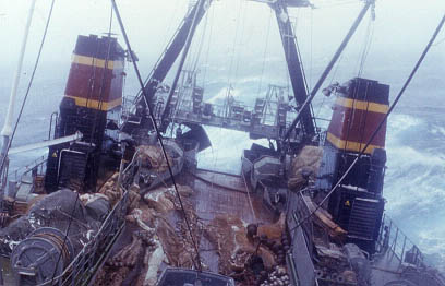
Gale force winds in the Southern Indian Ocean, home of the "roaring forties" can make fishing hazardous, if not impossible. Here the RTMS Zvezda Sevastopolya, a Super-Atlantic class trawler, dodges in heavy weather.
The wind regime in the area of ridges differs in summer (December - February). Easterly winds predominate in the region of the seamounts of the Ninety East Ridge located along the periphery of the centre with high pressures (occurrence 34%) and in the region of the seamounts of the Broken Ridge where weather conditions in this season form under the impact of the central part of the Southern Indian Maximum when there are southerly winds (occurrence 22%). The air temperature range varies greatly from the north to the south: from 27 °C at 20 °S to 12 °C at 40 °S. The mean extent of the sky coverage with clouds reduces from 6 - 7 points southwards from 33°S to 3 - 4 points in the region of 18 - 24° S. The occurrence of days with precipitation is less than 5%. Visibility is in the range of 8 - 9 points (Anon. 1979, 1982a, 1982b, 1982c).
The water circulation in the area is determined by the South Indian Ocean Current, which occurs along the southern periphery of the pertinent anticyclonic subtropical water gyre. When it reaches the western coast of the Australia southwards of 19°S it turns northwards forming the beginning for the Western Australian current and transport cold Sub-antarctic waters into the area of the southern tropics and in north into the anti-cyclonic gyre (Sukhovej and Baskaran 1995).
The oceanographic conditions of the south-eastern parts of the Ninety East and Broken Ridges are characterized by the active meandering and rings formation and the availability of the quasi-stationary frontal zones in the area of seabed elevations. The zones of upwelling and downwelling are peculiar for the area between 25° and 31°S. The general deepening of the subtropical waters on the way northwards is interrupted by upwelling in the zone between 27 and 29°S (Anon. 1982a).
![]()
![]()
![]()