![]()
![]()
![]()
Robert ROBEK and Mirko MEDVED\
Slovenian Forestry Institute, Ljubljana, SLOVENIA
Abstract
Road planning and design tasks for better integration of cable logging systems and access development are reviewed and illustrated with examples from Slovenia. In forest management plans the strategy for cable logging in mountainous terrain has to be drawn up. Within the integral opening up plans, the site specific match between cable and ground logging systems, existing infrastructure, reconstruction works and preliminary locations for new roads will be found. On cable logging terrain the road zero line must be adjusted for selected cable corridors layout from detailed terrain investigation. Contemporary cable systems require denser road networks. Therefore, minimization of site disturbance can be achieved with flexibility in profile, adjustments in plan view and adaptations in cross-section profile by using a set of templates for predefined yarder standings. Clearly formulated implementation requirements in documents provide the proper basis for construction works, contribute to feasible cable logging and facilitate sustainable forest management.
Introduction
In sustainable managed forests, roads, their network and technical specifications have to be in accordance with natural conditions and land uses (Abegg and Hünerwadel, 1983), expected logging operations (FAO. 1998) and landscape aesthetics (USDA Forest Service, 1995). In mountainous terrain suitable road networks in combination with cable logging are recommended (Dykstra and Heinrich, 1995) because of their favourable economical-ecological balance.
The established match between roads and cable systems in mountainous areas sooner or later become out of tune because of developments in cable systems, interventions in infrastructure, or spatial variations in applied harvesting technology. Although we are adapting cable systems to existing road networks during harvesting operations, the important part of the tuning may occur during changes in infrastructure. Among road construction activities, only during road planning and design can optimization be achieved. Optimization of the balance between road networks and cable systems in the planning process is difficult to obtain since different specialists and/or institutions are involved.
Tasks regarding implementation of the cable logging requirements in environmentally sound road construction occur at the strategic (policy), tactic (planning) and the operational (design) levels. Results are reported in corresponding documents so that the degree of implementation can be monitored. Tasks and solutions should be consistent and harmonized at various levels. Only then can the combination of apparently small adaptations at a particular level make a large and cost-effective contribution toward sustainability of forests. In this paper, different levels of road planning and design that yield a balanced match between road networks and contemporary cable systems are presented as checklists. The application of tasks at each level and the harmonization between levels are illustrated in examples from forestry practices in Slovenia.
Implementation at the strategic level
Forest management planning for implementation
Strategic plans should comprise the first step towards cable logging requirement implementation and future road networks. If there is no strategic plan for access and harvesting development, the regional forest management plan becomes a central document for periodic tuning of the harvesting system and infrastructure trends within forest management regions (FMR). The regional forest management plan is the basis for land use planning and environmental protection actions; hence it has to consist of directives for harvesting technology and access development.
Strategic directives must rely on present situation analysis and trend estimations. Both are based on available forest information systems and the qualifications of forest management planners. Usually they are not road or harvesting specialists. Therefore, the importance of road condition analysis and the role of infrastructure reconstruction and future traffic structure is often underestimated. These analyses affect the type of construction works, as well as the extent and type of cable logging. The comprehensive elaboration of a forest management plan for mountainous terrain must comprise the tasks presented in Table 1.
Table 1. Checklist for cable logging trends implementation in infrastructure development strategy
| Objective: Cable logging trends implementation in forest infrastructure development strategy | ||
| Past/present condition investigation tasks | task priority | |
| Land use, forest function and terrain classification | basic | |
| Present forest accessibility analysis | basic | |
| Recent harvesting technology allocation | basic | |
| Forest road and skid trail condition analysis | additional | |
| Guidelines and directives tasks | task priority | |
| Expected forest use mapping | basic | |
| Road improvements and reconstruction directions | basic | |
| Harvesting restricted area mapping | basic | |
| “Poor” forest access terrain mapping | additional | |
Formulated tasks provide the proper basis for roadnet and cable logging tuning within the next planning period. The basic tasks represent the minimal requirements. Together with optional tasks, they ensure the concretized implementation of cable logging requirements in general opening up plans. In the checklist, tasks are not listed hierarchically. The checklist can be used for guiding the planning process, as well as for a forest management plan evaluation and approval.
The absence of an infrastructure development strategy may favour ground skidding and skid trails in mountainous terrain. Besides their direct adverse site impacts, ground systems induce additional traffic in the forest stand which is undesirable in mountainous terrain.
An example: cable logging trend implementation in Slovenian State Forests
Problem areas and forest management systems
The total area of Slovenia is 2 025 400 ha. It has not changed since the liberation in 1991. At the end of the year 2000, there were officially 1 134 804 ha of forests in Slovenia, 31 percent of these State owned and located in large complexes, as well as spread among private forests. After the forest law was passed in 1993, the Slovenian Forest Service was established as a public service, responsible for all forests, and organized in 14 FMRs (approximately from 37 000 to 141 000 ha), regardless of ownership. FMRs are subdivided into forest management units (FMU) (approximately from 3 000 to 20 000 ha). The Slovenian Forest Service ensures public interest for the preservation and development of forests through 10-year strategic plans for FMR, 10-year forest management plans for FMU, as well as silvicultural plans.
All State forests are managed by the Slovenian Fund for Agricultural Land and Forests. The Fund, however, is not entrusted with operational management of State forests. It must contract out forest work in State forests to enterprises qualified for such jobs on a contract basis, or it must grant them a concession. Concession agreements, however, are not yet finalized. The majority of work in State forests is done by forestry companies, directly or with their subcontractors.
Cable logging and infrastructure situation in State forests
In Slovenia there is a long tradition of cable logging. Cranes were first used in Gorenjska (an alpine region near the Austrian border) in the second half of the nineteenth century. The data on cable cranes after 1950 (see Table 2) show that massive use of cable logging began with circled cranes.
Table 2. The number of cable cranes in Slovenian State forests
| Type of cable crane | 1950 | 1960 | 1970 | 1980 | 1990 | 2000 |
| Circled and others | 39 | 49 | ||||
| Classical cable cranes | 8 | 40 | 55 | 28 | 20 | - |
| Mobile skyline tower yarders | 14 | 15 | 35 | - |
After 1960 the “classical cranes” (Hinteregger, Wyssen, Gantner) appeared. They have fixed main ropes, separately mounted engines with drag ropes and different types of carriages. After intensive road construction in the period 1970 to 1990, as well as skid trails building and the implementation of tractors in the 1980s, their popularity decreased and mobile skyline tower yarders were fostered. At the beginning, they were mechanically driven (Urus, Mini Urus, Igland Telescope); but with the “Falke” tower yarder group, hydrostatic engines and radio-controlled carriages were used instead. There are four Syncrofalke cranes at the moment in Slovenia.
In the last 40 years, the amount of crane skidding in State forests has been constantly decreasing. From 1961 to 1965 the average annual amount of yarded wood by cable cranes in Slovenian State forests was 100 000 m3 but in the year 2000 it had dropped to around 45 000 m3. In the last five years, the share of cable logging in State forests was on average 6 percent - 82 percent of the volume was logged by tractors, 2 percent by horses and 6 percent manually (Kolšek, 2000).
The road construction boom occurred in the 1980s (see Table 3) and most skid trail construction occurred in the 1990s. At the end of 1992 the total amount of forest roads in Slovenia was 16 310 km, and 38 040 km of skid trails, respectively. Because of the lack of road construction investors in the 1990s, only skid trail construction took place. During the last four years in State forests only 15 km of new forest roads were constructed, and approximately the same amount reconstructed. At that time 739 km of skid trails were built and 329 km of skid trails reconstructed.
Table 3. Road construction intensity (average km per year) in Slovenia during the last 55 years
| Period | 1945–1950 | 1951–1960 | 1961–1970 | 1971–1980 | 1981–1990 | 1991–1993 | 1994–2000 |
| Newly built roads | 44 | 65 | 145 | 282 | 288 | 20 | 8 |
| Reconstructed roads | 19 | 40 | 91 | 99 | 56 | 14 | 9 |
| Total | 63 | 105 | 236 | 381 | 344 | 34 | 17 |
Road construction and cable logging trends
The road network in Slovene commercial forests does not provide economically feasible harvesting operations in steep terrain. In the State forests little new road construction in mountainous terrain and minor shifts in harvesting systems are expected in the next 10 years.
A steady rise in total yarded wood volume in Slovenian State forests is expected in the next ten years but the existing structure of cable logging technologies will not change significantly. Existing forest road networks in steep terrain will stimulate the use of cable mobile skyline tower yarders (see Figure 1). Line lengths from 200 to 400 m will predominate, implementing fan-like cable line networks wherever terrain conditions allow it.
Because of high construction costs and poor governmental support of new road construction, the majority of the “road business” will occur in the field of skid trail construction/reconstruction (see Figure 2). A minor part of these will take place in the moderate to difficult “tractor terrain” where modern tower yarders will be applied. These enable downhill skidding and have a bigger reach, but the constructed or improved low volume road will have to be suitably equipped/shaped for tower yarder standings and landings.
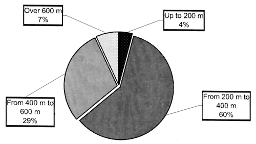
Figure 1. Planned wood volume from cable logging in Slovenian State forests in the year 2001
Since there is no general road access development strategy for Slovenian State forests, the corresponding regional forest management will be the basis for future activities on infrastructure. The implementation of cable logging requirements into regional access development strategies should be prepared and evaluated with the help of the checklist shown in Table 1 in order to achieve minimal impacts on stand, site and biological diversity.
Associated direct and indirect costs and collisions with other regional forest management objectives will also be kept to a minimum. Past investments in infrastructure and the present extent of cable logging (see Figure 2) show the importance of the implementation, which will differ significantly among forest management regions in the future also.
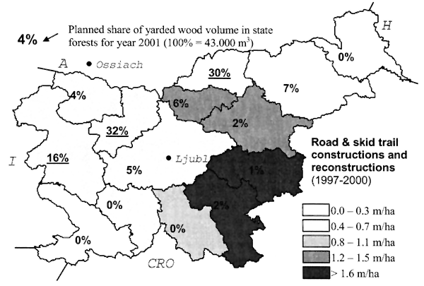
Figure 2. Differences in the amount of yarded wood by cable cranes and infrastructure investments among forest management regions in Slovenian State forests
Implementation at the road planing level
Integral opening up plan possibilities for implementation
Opening up plans are the most powerful tool for cable logging requirement implementation because they provide comprehensive and site-determined solutions regarding access development. Within the integral opening up plans, the site-specific match between cable and ground logging systems, existing infrastructure, reconstruction works and preliminary locations for new roads will be obtained.
Today the value of integral opening up plans are under-rated because of the general opinion that investment in low volume roads or skid trails does not pay. In contrast to road design projects, for which it is obligatory to obtain construction permission, opening up plans are usually prescribed only for main forest roads that are important for rural and local traffic, where environmental impact assessment and investment argumentation are requested.
Several possibilities for implementation of the cable logging requirements in integral opening up plans exist. Modern opening up plans cover smaller areas, therefore, situations are in fact less complex. Availability of the site condition data has increased in the information era. Utilization and availability of the GIS/GPS tool speed up analysis and sophisticated outputs including links to road and cable line design. Thus the influence range of the existing road or skid trail corridors can instantly be obtained by using buffer options. Structuring the study area by using classifications and overlaying is faster, and modelling the alternative routes through positive and negative cardinal points is easier.
Even when physical maps and the analogue approach is used, several benefits can be expected with integral opening up plans. During scooping, the objectives and issues are clarified and the parties involved activated, which is particularly important in areas with dense population and complex forest management goals. The environmental benefits of the entire system are more seriously considered. The existing infrastructure is analysed and often at least partially improved for future harvesting operations.
The major result of the opening up plan is conceptual harmonization of the access development and harvesting technology. Therefore, only site determined reconstruction guidelines and preliminary locations of new roads and skid trails are derived. Regarding cable logging requirement implementation, the following results can be obtained with the following opening up plan:
Table 4. Checklist for cable logging requirement implementation in opening up plans
| Objective: Site specific cable logging requirements implementation in integral opening up concept | ||
| Integral approach tasks | task priority | |
| Formulation the access concept in planing area | basic | |
| Harvesting prescription and limitation analysis | basic | |
| Existing infrastructure condition assessment | basic | |
| Site sensitivity mapping | basic | |
| Local logging tradition and cable system availability | additional | |
| Alternative evaluation tasks | task priority | |
| Concerned parties involvement protocol | basic | |
| Target harvesting system determination | basic | |
| Cardinal point determination and evaluation | basic | |
| Priorities in access development | basic | |
| Ecological and economical comparisons of the alternatives | additional | |
| No activity option analysis | additional | |
In order to achieve these results, the tasks listed in Table 4 are required. Implementation at road planing level goes through a process of identification of the need for an integral approach and process of evaluation of alternatives. A top down and bottom up approach is possible. Identification of the needs may occur within forest management plans, harvesting plans or individual road design projects. Part of the alternative evaluation tasks can occur at the planning stage, or are the first step in road design.
An example: urban forest opening up plan
Forest ecosystems need no roads, trails and paths, while in managed forests these communications become vital corridors for utilizing their economic and social values. The example shows an access plan for part of the urban forests of Celje, the third largest city in Slovenia. The opening up objective was oriented towards minimization of the conflicts between logging and recreation on the same ground. Each of them requires its own type, amount and layout of infrastructure. Visitors are guided through the desired corridors along trails and pathways, while silvicultural interventions may take place on the entire area. According to the opening up aims and constraints, we developed an access model with the following characteristics:
The entire area of the southern edge of the Celje urban forests has been partitioned into several study areas (usually delimited by public roads) with a uniform access model, i.e. the same concept of opening up. Here we report the general opening up plan for the study area Anski vrh (72 ha) which was further partitioned into seven infrastructure units. The proposed general opening plan is summarized in Table 5.
For cable logging terrain, uphill yarding (200–400 m) on the gravelled low volume intervention road was planned. Because of different harvesting directives issued during the eight years of the forest management plan for that area and the lack of a cable logging tradition in this area, the proposal was rejected by the District Forest Service authorities. Instead, 5 hectares of cable logging terrain was allocated into tractor skidding terrain and the rest into hand skidding terrain.
Table 5. Planned logging and the recreational infrastructure on Anski vrh
| Type of area | ha | Length structure (m) | |||||
| Landing/entry area | 2 | Planned measure | Recreational paths | Tractor trails | Intervention paved roads | ||
| Cable logging | 9 | marked | unpaved | ||||
| Tractor skidding | 40 | Abandoned | 3 115 | 140 | 385 | 0 | |
| Horse hauling | 2 | Periodic maintenance | 1 085 | 0 | 595 | 875 | |
| Recreational access | 9 | Reconstruction | 420 | 120 | 735 | 525 | |
| Inaccessible | 10 | Construction/use | 280 | 720 | 455 | 1 120 | |
The rejection of cable logging caused increased skid trail construction and enlarged inaccessible areas for economically feasible harvesting. Although forest management has a ten-year horizon, the consequences will last longer. Even if we could introduce cable systems into the area, skid trails will continue to disturb the site, they will require funds for maintenance, and additionally the implementation of cable logging will also require construction works and financing.
Implementation at the road design level
Road design project opportunities for implementation
The road design project is the last and the most precise compilation of the tasks required for tuning the road location and its characteristics for optimal cable system operation. It can be applied to new construction or reconstruction, but in the last case tasks regarding road location are irrelevant. The exceptions are short (<100 m) sections with ends shaped for cable corridor location, and they are often treated as reconstruction.
On cable logging terrain, selected preliminary locations have to be upgraded into suitable zero lines in a way to integrate selected cable systems, efficient cable corridors layout and available terrain possibilities. These tasks are carried out during reconnaissance and detailed terrain investigation. Road design is the most delicate task in cable logging requirement implementation regarding environmental and economic issues.
Contemporary cable systems require denser road networks. Therefore, minimization of the site disturbance can be achieved with flexibility in profile view, adjustments in plan view and adaptations in cross-section profile by using a set of templates for predefined yarder standings. The use of suitable software can speed up the process when it is in accordance with the surveying praxis and required data precision in forestry.
Tasks for mobile tower yarder requirement implementation into road design projects are presented in Table 6. Although they represent important technical improvements in the road, their role is overestimated in comparison to the tasks in higher/previous levels.
Table 6. Checklist for cable logging requirements implementation in a road design project
| Objective: Cable system requirement implementation in a road design project | ||
| Tasks for zero line adjustment for cable logging | task priority | |
| Harmonisation the road standard with traffic characteristics | basic | |
| Detailed delimitation between target harvesting systems | basic | |
| Field determination/fixation of the major locations for yarders | basic | |
| Reconnaissance minute | basic | |
| Extended terrain characteristics description at cross-section | basic | |
| Tasks for final adjustment of the location line | task priority | |
| Cross-section template determination | basic | |
| Slope and ditch adjustment around landings/yarder places | basic | |
| Reinforcement of fill slope at cable cross sections | basic | |
| Prescriptions for clearing width and anchoring requirements | basic | |
An example: cable logging adjusted low volume road “Ojstrovica”
Road layout adjustment
An opening up area was situated 2.7 km southwest from the village of Lokve (west Slovenia), about 1 200–1 400 m above sea level (a.s.l.) (see Figure 2). The proposed low volume forest road “Ojstrovica” is 901.60 m long and it will open up approximately 31 ha of commercial State-owned forests on the steep karst terrain, where no roads or skid trails exist so far.
Integral opening plans for the area do not exist. No public restrictions exist on the opening up area. Around the top of the hill the timberline limit is indicated and no harvesting expected. No collision with the local inhabitants or NGOs is expected.
Nineteen hectares are allocated for cable logging with Syncrofalke tower yarder, but the rest of the area will be logged with skidders. Delimitation between ground skidding and cable terrain was done in accordance with the district forester from the logging company.
The district forester proposed in the beginning two preliminary routes gravitating to another existing road, but because of their length and terrain sensitivity the access concept was changed, new cardinal points identified and a new preliminary location agreed. Skid trail construction will not be performed simultaneously.
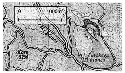
Figure 3. Situation of the forest road “Ojstrovica” opening up area and harvesting technology plan
Designed side-hill road is situated around the top of Ojstrovica hill (1 260 m a.s.l.) where the average terrain slope along the route is 67 percent (maximum 82 percent). Several shelves were identified during reconnaissance and the preliminary road location was adjusted to them. The origin of the compact fine-grained calcareous bedrock is Jurassic. There is no evident surface water sources or obvious muddy soils. The southeast side of the hill is steeper than the northwest side and evidently ribbed. Besides the hilltop, the most evident relief feature is the sharp ridge on the west side.
Road design adjustment
The target road standard is G3 (one lane, low volume, gravelled forest road). The target vehicle is the triple-axis truck; maximum allowed weight up to 30 tonnes. The planned driving speed is up to 30 km per hour. The minimal horizontal radius is 9 m and maximum vertical grade, 12 percent.
The positions for tower yarders were identified around the preliminary road location, some selected for positive cardinal points and fixed. Cardinal points were connected, preliminary grade lines staked and basic survey data obtained. No horizontal adjustment was performed at that time.
During computer assisted road design the standard cross-section for a low volume road was determined (see Figure 4a). Upon it the set of cross-section template was created for log landings, tower yarder standings (see Figure 4b) and variable slope/bedrock conditions. Mass balance was optimized with careful horizontal and vertical alignment. The road drainage objects were designed with special attention to “cable” cross-sections. The final version of the earth works was calculated and graphic output elaborated, together with the required documentation for construction permission. For low volume forest roads, no official environment impact assessment was needed at that time.
Conclusions
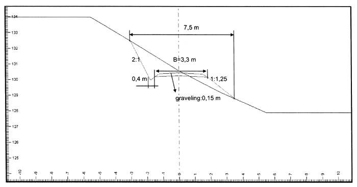
Figure 4a. Standard cross-secton for low volume road “Ojstrovica”
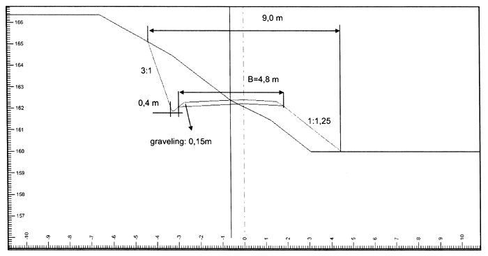
Figure 4b. Tower yarder location cross-section for low volume road “Ojstrovica”
References
Abegg, B. & Hünerwadel, D. 1993. Zur Methode der Walderschliessungsplanung - ein Erfahrungsnbericht. Berichte, Nr. 252, Eidgenössiche Anstalt für das forstliche Versuchswessen, CH 8903 Birmensdorf. 43 pp.
FAO. 1995. FAO Model Code of Forest Harvesting Practice, by D.P. Dykstra and R. Heinrich. FAO.Rome. 117 pp.
FAO. 1996. Forests and forestry in Slovenia, by A. Golob. Report of the FAO/Austria Seminar on Economics and Management of Forest Operations for Countries in Transition to Market Economies. Ort/Gmunden, Austria, 27 June–3 July 1994. FAO. Rome. p. 173–184.
FAO. 1998a. A manual for the planning, design, and construction of forest roads in steep terrain. Draft. FAO, Rome. 188 pp.
FAO. 1998b. Environmentally sound road construction in mountainous terrain, by N. Winkler. Applying advanced operating methods and tools. Forest Harvest Case Study, 10. FAO, Rome. 54 pp.
FAO. 1999. Environmentally sound forest operations in Slovenia for whom? by R. Robek and J. Marenče, p. 89–94. In Proceedings of the FAO/Austria Meeting on Environmentally Sound Forest Operations for Countries in Transition to Market Economies. Ort/Gmunden, Austria, 20–27 September 1998. FAO, Rome.
Hirt, R. 1989. Methoden zur Beuerteilung und Bewertung von Integrale Erschliessunen. Program Sanasilva: Integrale Erschliessugsplanung land-und forstwirtschaftlich genutzer Gebiete im Vorlapen- und Alpenraum, Vitznau, September 1989, Institut für Wald- und Holzforschung Fachbereich Forstlices Ingenieurwesen ETHZ, p. 2–14.
Kolšek, M. žično spravilo v državnih gozdovih (Cable logging in Slovenian State forests). Slovenian Fund for Agricultural Land and Forests, Ljubljana. 4 pp.
Košir, B., Medved, M., Dobre, A. & Bitenc, B. 1993. Stanje mechanizacije ter storilnosti in izkoriščenje delovnega časa delavcev v neposredni proizvodnji gozdarstva R Slovenije konec leta 1992 (a survey of mechanization, productivity and the utilization of working timestage in forestry manual workers in the Republic of Slovenia at the end of 1992). Gozdarski inštitut Slovenije, Strokovna in znanstvena dela, 114. p. 12–34.
Kuonen, V. 1989. Eunführungsreferat: Integrale Erschliessungsplanung. Program Sanasilva: Integrale Erschliessugsplanung land-und forstwirtschaftlich genutzer Gebiete im Vorlapen - und Alpenraum, Vitznau, September 1989, Institut für Wald-und Holzforschung Fachbereich.
Wästerlund, I. & Hassan, A. E. 1995. Forest harvesting systems friendly to the environment. Swedish University of Agricultural Sciences, Dept. of Operational Efficiency, Garpenberg, Research notes, No. 277, 30 pp.
Wästerlund, I., 1997. Poročilo Zavoda za gozdove Slovenije o gozdovih za leto 1996 (Slovenian Forest Service Report on Forests in 1996). Zavod za gozdove Slovenije.
Wästerlund, I., 1998. Poročilo Zavoda za gozdove Slovenije o gozdovih za leto 1997 (Slovenian Forest Service Report on Forests in 1997). Zavod za gozdove Slovenije.
Wästerlund, I., 1999. Poročilo Zavoda za gozdove Slovenije o gozdovih za leto 1998 (Slovenian Forest Service Report on Forests in 1998). Zavod za gozdove Slovenije.
Wästerlund, I., 2000. Poročilo Zavoda za gozdove Slovenije o gozdovih za leto 1999 (Slovenian Forest Service Report on Forests in 1999). Zavod za gozdove Slovenije.
![]()
![]()
![]()