![]()
![]()
![]()
There are four main soil-order types in Iran, i.e. Entisols, Aridisols, Inceptisols, and Alfisols. According to Dewan and Famouri (1964), the most important soils of plains and slopes consist of alluvial, colluvial, humic-clay and various kinds of salt-affected soils belonging to the major classes Aridisols, Entisols, Inceptisols, and Alfisols. Due to their origin, many soils of the country are rich in calcium carbonate and are classified as calcareous. Plant availability of most nutritional elements, especially micronutrients, is low. The proportions of the dominant soil types are shown in Figures 3 and 4.
FIGURE 3
Soil type distribution
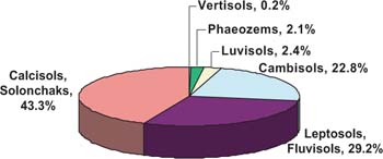
Source: Moameni, 2000.
Soil survey and land classification studies during the past 50 years reveal that the majority of land resources possess various degrees of limitations, either individually or in combination, related to soil properties, salinity and alkalinity, topography, erosion and drainage. Therefore, the production capacity of soil resources of the country depends not only on the degree of soil salinity but also on other soil deficiencies that hinder sustainable crop production.
In Iran, soil characterization and mapping are based on the standards given in the Guide for Soil Survey and Land Classification for Irrigation, prepared by the Soil Institute of Iran, affiliated to the Ministry of Agriculture, with the help of FAO experts. In accordance with the standards given in this guide, land areas were grouped into six classes, depending on their capabilities and limitations as regards the cultivation of annual crops under gravity irrigation, assuming that no land improvement is carried out which would remove the present limitations and improve the quality of the land.
FIGURE 4
Dominant soil map of Iran
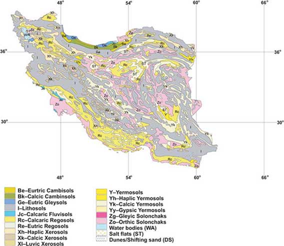
TABLE 1
Main land classes and subclasses
|
Land classes |
Basic subclasses |
|
Class I: Arable |
S = Soil limitation, (texture, dept, soil permeability, infiltration rate, etc.). |
|
Class II: Arable |
A = Salinity or alkalinity limitation. |
|
Class III: Marginal, Arable |
T = Topography/erosion limitation. |
|
Class IV: Restricted, Arable |
W = Drainage limitation (flooding, ponding, presence of groundwater, pseudo gley, etc.). |
|
Class V: Undetermined, Arable |
|
|
Class VI: Non-Arable |
|
Source: Moameni, 2003.
TABLE 2
Areas covered by land classes
|
Land classes |
Area |
|
|
('000 ha) |
(percent) |
|
|
Class I |
1 300 |
6.5 |
|
Class II |
4 290 |
21.5 |
|
Class III |
5 340 |
26.7 |
|
Class IV |
3 120 |
15.6 |
|
Class V |
2 700 |
13.5 |
|
Class VI |
2 250 |
11.3 |
|
Complexes (any cross bred of above land classes) |
1 000 |
5.0 |
|
Total |
20 000 |
100.0 |
Source: Moameni, 2003.
Depending on the type of limitation, land classes lower than class I land were subdivided into subclasses by appending to the class number a letter showing the type of limitation (Table 1).
The results of the soil survey and land classification activities in Iran (reconnaissance, semi-detailed and detailed), obtained from 1953 to 2000 are shown in Table 2. Of a total of 20 million hectares of land surveyed, which included most of the cultivated land, good-quality land (class I land) covers only 1.3 million hectares (6.5 percent). The remaining land areas have various degrees of limitations and/or hazards for irrigated farming.
Class I land has no limitations as regards salinity, topography or drainage, for irrigated farming under existing conditions. It is capable of producing sustained high yields of a wide variety of climatically adapted crops, at reasonable costs under good management. These land areas are considered to be highly sustainable for irrigated farming and have a high income potential under normal conditions of soil and water management.
However, in the semi-arid conditions of the country, their productive capacities are threatened by mismanagement. If crop production on these soils is to be sustainable, changes in their quality under irrigation farming must be monitored through long-term studies.
Land areas having slight to moderate hazards and/or limitations of soil, salinity, topography or drainage, for irrigation farming (class II + class III lands) cover about 9.5 million hectares or about 48 percent of the total land areas surveyed (Table 2). Moderately suitable land areas for irrigation (class II lands) are either suitable for a somewhat narrower range of crops compared with class I land areas or are more costly to prepare for irrigation (drainage, leveling, etc). Under present conditions, these land areas are expected to give lower yields, compared with class I land. Land areas that are marginally sustainable for irrigation (class III land) either have restricted crop adaptability or are expected to give lower yields than those of class II land, or require more costly land improvement and land preparation operations or more costly management practices.
The problematic lands (class IV, V and VI land areas) cover about eight million hectares or 40.5 percent of the surveyed area and undifferentiated land (complexes) cover about one million hectares or 5 percent.
Owing to their severe limitations of soil and/or topography for irrigation farming, class IV lands are considered to be unsuitable for irrigation under normal conditions of irrigation management. Under present conditions, they must be used for the cultivation of special crops or with special conditions of management that can cope with these limitations. Under normal conditions of management most of the common tilled crops cannot be grown profitably on these land areas. However, under special conditions (operation in units of abnormal size such as very intensive, or extensive cropping, irrigation from cheap sources of water, including flood waters, irrigation on steep slopes either after terracing, or by sprinkler, special crops such as vegetables, fruit trees, rice, pasture) irrigated farming can be profitable. This category of land also includes areas on which crops such as date palms, rice, etc. can be grown under severe limitations of salinity and/or drainage.
Class V land areas are considered to be at present unsuitable for irrigation because of their severe hazards and/or limitations of salinity and/or drainage for any type of irrigation farming. If freed from limitations such as salinity and excess water, these land areas could play an important role in crop production and hence in the economic development of the country. In most cases, however, they require substantial land improvement operations. It must be proven through investigations and trials that crop production on these land areas is not only possible but also economically feasible.
Class VI land areas possess hazards and limitations for any type of irrigated farming under present conditions. Since their reclamation is not technically and/or economically feasible at present, they are considered to be non-arable land areas.
TABLE 3
Provinces in the agro-ecological
zones
| |
Agro-ecological zone |
Provinces |
|
1 |
Central Zone |
Markazi, Qazvin, Qom, Semnan, Tehran |
|
2 |
Caspian Coastal Plain Zone |
Gilan, Golestan, Mazandaran |
|
3 |
North-Western Zone |
Ardabil, East Azarbaijan, Kordestan, West Azarbaijan, Zanjan |
|
4 |
Central Zagros Zone |
Hamedan, Ilam, Kermanshah, Lorestan |
|
5 |
Khuzestan Zone |
Khuzestan |
|
6 |
Arid Central Zone |
Esfahan, Yazd |
|
7 |
Southern Zagros zone |
Chaharmahal and Bakhtiyari, Fars, Kohkilooyeh and Boyerahmad |
|
8 |
Southern Coastal Plain Zone |
Bushehr, Hormozgan |
|
9 |
Arid Southern Zone |
Jiroft, Kerman, Sistan and Baluchestan |
|
10 |
Khorasan Zone |
Khorasan |
Source: Booker and Hunting, 1965.
Iran has been broadly divided into different agro-ecological zones in accordance with their similar conditions of climate and the type of crops grown (Table 3 and Figure 5).
In Table 4, the cultivated area and agricultural crop and orchard production in the different agro-ecological zones in 2001/02 are shown. Approximately 44 percent of the cultivated crops are rainfed and they produce only 12 percent of the total crop production. However, rainfed wheat accounts for about 35 percent of the total production and rainfed barley for about 34 percent. Ninety percent of the orchards are irrigated (ASSC, 2004; Agronomy Department, 2004; Malakouti et al., 2004).
|
Zone 1 - |
Central zone: The southeastern part of the zone is situated in dry climatic conditions while the vast western part has seasonal dry conditions. This zone has sedimented soils, calcareous Lithosols and saline swamps. |
| |
|
|
Zone 2 - |
Caspian Coastal zone: With wet and humid conditions this expanse covers the coast of the Caspian Sea. |
| |
|
|
Zone 3 - |
Northwestern zone: This zone covers the north west part of country. It has seasonal dry periods, moderate summers and extreme winters. |
| |
|
|
Zone 4 - |
Central Zagros zone: With good rainfall in winter, this region is characterized by dry, warm winds in May-June. |
| |
|
|
Zone 5 - |
Khuzestan zone: Extreme transpiration, very hot and humid, this zone in winter has temperatures which can go below 0°C. |
| |
|
|
Zone 6 - |
Arid central zone: To the east of this zone is the dry Dasht-e-Kavir desert. But there are parts to the west which receive good rainfall. |
| |
|
|
Zone 7 - |
Southern Zagros zone: The average rainfall crosses 270 mm. This region is characterized by extremely warm springs. |
| |
|
|
Zone 8 - |
Southern coastal plain zone: The average temperature rarely goes below 15°C and the rate of evapotranspiration is high in winter. This region has seasonal dry conditions. |
| |
|
|
Zone 9 - |
Arid Southern zone: With cold winter and warm summers, this zone has similar climatic conditions to zone 8 in that the temperature rarely falls below 15°C. |
| |
|
|
Zone 10 - |
Khorasan zone: This zone has an average rainfall between 240-270 mm per year. It is characterized by long cold winters and late rainfall. |
FIGURE 5
Map of agro-ecological zones of
Iran
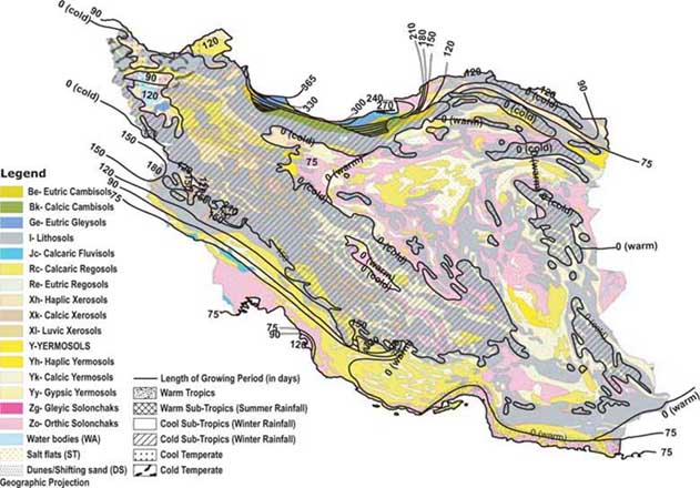
TABLE 4
Cultivated area and agricultural production by
agro-ecological zone, 2001/02
|
Zone |
|
Cultivated area |
Agricultural production |
||||
|
N° |
Name |
Irrigated |
Rainfed |
Total |
Irrigated |
Rainfed |
Total |
|
1 |
Central Zone |
881 |
269 |
1 151 |
7 445 |
188 |
7 633 |
|
2 |
Caspian Coastal Plain Zone |
840 |
640 |
1 480 |
4 598 |
3 110 |
7 708 |
|
3 |
North Western Zone |
1 829 |
2 357 |
4 186 |
9 655 |
1 930 |
11 585 |
|
4 |
Central Zagros Zone |
691 |
1622 |
2 313 |
5 333 |
188 |
5 521 |
|
5 |
Khuzestan Zone |
623 |
358 |
981 |
7 723 |
438 |
8 161 |
|
6 |
Arid Central Zone |
518 |
97 |
614 |
4 807 |
126 |
4 933 |
|
7 |
Southern Zagros Zone |
929 |
424 |
1 353 |
8 650 |
597 |
9 248 |
|
8 |
Southern Coastal Plain Zone |
197 |
183 |
379 |
2 130 |
102 |
2 231 |
|
9 |
Arid Southern Zone |
716 |
14 |
729 |
4 598 |
25 |
4 623 |
|
10 |
Khorasan Zone |
1 043 |
531 |
1 573 |
7 610 |
354 |
7 964 |
|
|
Total |
8 266 |
6 493 |
14 759 |
62 549 |
7 058 |
69 607 |
Table 5 presents the areas under the major crops.
Information on the main crops, irrigated and rainfed areas under cultivation, total fertilizer use and the fertilizer nutrient ratios, in each province of each agro-ecological zone, is given in the Annex.
Until recently, Iran relied heavily on wheat imports to meet its growing domestic demand. Annual imports have ranged from 2.5 to 7.5 million tonnes per annum during the past two decades, making Iran a major world wheat importer. A record production in 2004 following an already excellent crop in 2003 reduced imports in 2004/05 to 0.2 million tonnes. Over the past two years, the Government has sharply increased spending on wheat farming by supplying higher quality seeds, improving machinery services, augmenting fertilizer usage and enhancing water systems and pest management practices. The guaranteed procurement prices have been raised significantly. Strong government support for wheat production has played a large role in raising output but favourable weather during these seasons also has had a major impact. At least 40 percent of Iran's wheat is rainfed with an average yield of only 0.8 tonnes/ha. Even under irrigation the average wheat yield rarely exceeds 3 tonnes/ha, which is low by world standards. (FAO, Food Outlook, April 2005).
TABLE 5
Areas of the major crops in 2004
|
Crop |
Area ('000 ha) |
|
Wheat |
6 600 |
|
Barley |
1 600 |
|
Rice |
570 |
|
Maize |
250 |
|
Pulses |
1 185 |
|
Oil crops |
380 |
|
Fruit crops |
1 141 |
|
Vegetable crops |
550 |
|
Other crops and fallow |
4 224 |
|
Total |
16 500 |
Source: FAOSTAT.
Evidently a continuation of favourable weather cannot be guaranteed and efforts to improve yields by manageable means are clearly indicated. These means include balanced and efficient fertilization.
On the basis of the three criteria of moisture regime, winter type and summer type, a total of 28 agro-climatic zones has been differentiated, of which only six (A-C-W, A-C-VW, A-M-VW, SA-K-W, SA-C-W, and SAK-M) occupy nearly 90 percent of Iran (Figure 6 and Table 6).
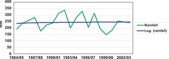
The annual rainfall in the past two decades is shown in Table 7 and Figure 7.
Of the 15.5 million hectares of cultivated land, over 7 million hectares or 45 percent are under irrigated agriculture (including fallow), with an average holding size of 2.9 ha. By far the most important irrigated crop is wheat.
Salinity and drought are among the most important environmental stresses that limit crop production in Iran. Low rainfall, high air temperatures and high evaporation rates are the main factors that cause water stress and contribute to the development of a saline environment surrounding the plant roots. Natural soil salinity and high concentration of salts in irrigation waters aggravate the situation.
To reduce the impact of these stresses on crop growth, agronomic and genetic approaches may be employed. The advances in biotechnology have made it possible to look for genes that control certain traits suitable for crop tolerance or avoidance of such stresses. Once they are identified, these genes can be transferred from the original genotype to other genotypes or cultivars of a certain crop using genetic engineering procedures. In many regions of Iran, freshwater resources are in short supply. However, saline surface streams or poor-quality groundwater sources are available in large volumes. In such regions, growing salttolerant crop species can dramatically increase agricultural output.
There are extensive areas where soils are potentially suitable for crop production but where water is inadequate for economic crop production. Growing drought-tolerant crops can greatly contribute to the economic development of such areas.
According to records in the Planning and Economics Division of Jahad-e-Agriculture Ministry (The Institute for Planning Research and Agricultural Economics), the area under irrigated agriculture has increased from 4.7 to 7 million hectares. It is planned that the area of irrigated land should increase to 10 million hectares by the year 2020. However, during the past 25 years only some 483 000 hectares have been added to irrigated farmland, despite a great deal of effort.
Surface irrigation techniques are used on 98.8 percent of the area equipped for irrigation, 1.2 percent using pressurized irrigation systems. In general, irrigation has a low efficiency, 30 percent as a national average, losses in conveyance and use being very high (FAO, AQUASTAT, Iran country report).
In some areas, a petrogypsic horizon is present in the soil profile, in which secondary gypsum has accumulated to such an extent that the horizon is cemented or indurated. Under these conditions, and if the natural soil drainage is poor, irrigated farming leads to soil salinization. Due to various problems associated with irrigated farming on such soils, it is recommended that such areas should be devoted to pasture.
FIGURE 6
Agro-climatic zones
Source: de Pauw, Gaffari and Gasenic, 2002.
TABLE 6
Agro-climatic zones of Iran, moisture,
temperature and area
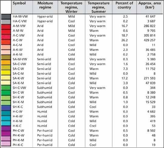
Source: de Pauw et al., 2002.
TABLE 7
Average annual rainfall during the last two
decades
|
Year |
Average rainfall (mm) |
Year |
Average rainfall (mm) |
Year |
Average rainfall (mm) |
Year |
Average rainfall (mm) |
|
1984/85 |
192 |
1989/90 |
223 |
1994/95 |
282 |
1999/00 |
148 |
|
1985/86 |
238 |
1990/91 |
238 |
1995/96 |
331 |
2000/01 |
182 |
|
1986/87 |
261 |
1991/92 |
314 |
1996/97 |
205 |
2001/02 |
254 |
|
1987/88 |
282 |
1992/93 |
339 |
1997/98 |
314 |
2002/03 |
247 |
|
1988/89 |
176 |
1993/94 |
202 |
1998/99 |
195 |
2003/04 |
243 |
FIGURE 7
Rainfall trends during the past two
decades
![]()
![]()
![]()