![]()
![]()
![]()
1.1.1 The coastal zone discontinuity
Coastal ecosystems, found along the margins of the world's large water bodies, are regions of remarkable biological productivity, high accessibility and great importance to society. They have been centres of human activity for millennia. Coral reefs, mangroves, tidal and non-tidal wetlands, sea grass beds, barrier islands, estuaries, peat swamps, lagoons, river reaches, deltas, coastally restricted forests, sea and land ice and other terrestrial ecosystems constitute the integrated, cross-boundary coastal zone. Each of these ecosystems, and its associated habitats and biota, provides its own distinct bundle of goods and services and faces somewhat different pressures from human activity, habitation, commerce and recreation; they provide agricultural products, fish, shellfish and seaweed for both human and animal consumption, and they are a considerable source of fertilizer, pharmaceuticals, consumer products and construction materials (Costanza, 1999; Cohen et al., 1997; Jackson, Kurtz and Fisher, 2000; Scialabba, 1998). Valuable ecological services come from a broad range of habitat types harbouring a wealth of species and genetic diversity (Christensen et al., 1996; MA, 2003). Coastal ecosystems store and cycle nutrients, filter pollutants from inland freshwater systems, and help to protect shorelines from erosion and storms. Furthermore, near-shore coastal waters provide another suite of ecological goods and services (UNESCO 2003c). Coastal zones are thus among the most important areas in the world to humans and one of the most sensitive to global change.
1.1.2 Global coastal monitoring needs
The global community's early recognition of the importance of coastal ecosystems and monitoring was shown in the outcomes of two conferences: the Convention on Wetlands held in Ramsar, Iran, in 1971, and the UN Conference on the Human Environment held in Stockholm, Sweden, in 1972. In 1992 the UN Conference on Environment and Development in Rio de Janeiro, Brazil, provided an international forum on the concept of sustainable development. The Agenda 21 plan was one of the major resulting products. Chapter 17 of Agenda 21 contained provisions for the protection of oceans, seas, coastal areas and related resources, providing a political instrument for including the sustainable development concept in the management of coastal areas. Commitments to sustainable use of coastal areas have been made since the Rio convention through such global instruments as the UN Convention on the Law of the Sea (UNCLOS), the Convention on Biological
Diversity (CBD), the Barbados Action Plan, the Global Programme of Action (GPA) for the Protection of the Marine Environment from Land-Based Activities, and the Food and Agriculture Organization of the United Nations (FAO) Code of Conduct for Responsible Fisheries, and associated action plans (Duda and Sherman, 2002). International organizations and nations alike responded to the new coastal resource management needs in a number of ways. UN agencies developed and endorsed guidelines for Integrated Coastal Area Management (ICAM) (Scialabba, 1998; UNESCO, 2003a; UNEP, 2004). Programmes such as the Regional Seas Programme (RSP) and the Large Marine Ecosystems projects (Sherman and Duda, 1999) drew multinational cooperation, and scientific programmes researched the social and environmental causes of the degradation of coastal resources (GESAMP, 2001).
All of these political instruments, management programmes and research activities require global and regional resource assessments, as well as associated data collection infrastructure. Furthermore, recent environmental targets set by the Millennium Development Goals and the World Summit on Sustainable Development (WSSD) in 2002 emphasize the need for ongoing mechanisms for monitoring coastal areas and strengthening Agenda 21 coastal initiatives. A number of existing and planned international initiatives are being developed in support of these coastal assessment needs. The three global observing systems (Global Terrestrial Observing System [GTOS], Global Climate Observing System [GCOS] and Global Ocean Observing System [GOOS]), in collaboration with their partner global monitoring and research programmes, are addressing this issue through the development of a Coastal Theme for the Integrated Global Observing Strategy (IGOS). This document presents a strategy for developing a Coastal Module of GTOS (C-GTOS) and describes how it will be initially implemented.
1.1.3 Integrating the coastal components of the global observing systems
The coastal zone presents particular challenges to observing systems; the environmental diversity is great, the ecosystems span a wide range of productivities and susceptibilities to disturbance, and human populations are dense in many coastal areas and their activities significantly use and modify habitats (Nixon, 1995; Bijlsma et al., 1996; UNEP, 1997). The oceanographic community conducted early planning efforts through the design of the Coastal GOOS Panel, Living Marine Resources, and Health of the Oceans programmes, under the auspices of the Intergovernmental Oceanographic Commission (IOC). These programmes are currently merged into a common programme using the Coastal Ocean Observations Panel (COOP) (UNESCO, 2000). The COOP strategic plan has been formulated (UNESCO, 2003c), and the implementation plan is being developed for the Coastal Ocean Observations Module of GOOS (C-GOOS). Many of the specific operational activities of these planning efforts are to be implemented through regional and national observing systems. The overall focus is on assessing aspects of global change within the ocean, particularly coastal waters. The land, wetlands and freshwaters are considered important determinants of inputs and boundary conditions for coastal waters. Information about land-based conditions is crucial to C-GOOS, but the acquisition of that information is outside the perceived realm of responsibilities of these oceanographic programmes. Furthermore, assessing socio-economic interactions with global and large-scale change in the coastal zone requires land-based assessments. Therefore, GTOS has initiated the coastal Module, which will be responsible for collecting and managing observations, including socio-economic information, concerning the terrestrial, wetland, coastal freshwater and, when appropriate, transitional water ecosystems.
The development of C-GTOS begins with a vision of its goals (see Section 1.2) and objectives. This vision suggests a strategic design, and details for implementation are established within the context of this design. The Coastal Panel of scientific experts have begun the process of defining goals and objectives for the observing system and establishing steps for its implementation. Several frameworks provide a structure to in which to consider the goals of C-GTOS. The primary one is the Driver-Pressure-State-Impact-Response (DPSIR) framework, which links ecological and human conditions and activities proposed through C-GTOS and the Coastal Theme of the IGOS. Other frameworks provide insight into other complexities of, and interactions within, the coastal zone.
Initially, the C-GTOS Panel of scientific experts identified selected "states" (sensu DPSIR) or attributes of the coastal ecosystems associated with state changes. Variables or observations to detect status and change in states were delineated and linked to prospective sources of information on these variables. The C-GTOS Panel members then examined networks of programmes known to sample the coastal environment in ways that can support the observing system. This information was placed in the context of the Terrestrial Environmental Monitoring Sites (TEMS) web database of GTOS, and gaps in our ability to make observations were noted.
Second, the group focused on identifying significant and appropriate questions and priority products for addressing these questions. This iteration narrowed the range of issues of consideration and observations. The group then proposed discrete products to structure the early activities of C-GTOS. These products are designed to provide clear evidence of the value of C-GTOS. Further, the panel members engaged user groups for C-GTOS products. The mature C-GTOS will build upon these initial activities and is envisioned as providing a more systemic approach in collaboration with C-GOOS.
The implementation plan developed through a series workshops and follow-up activities with the GTOS coastal panel of scientific experts. The final writing session and review included contributions from individuals of numerous international coastal management and research organizations. The first workshop occurred at East Carolina University in Greenville, North Carolina, USA, from 15 to 18 October 2002. The second workshop was held at the Joint Research Centre of the Institute for Environment and Sustainability in Ispra, Italy, from 3 to 6 March 2003. The third workshop was at the La Selva Biological Station, Costa Rica, from 19 to 22 October 2003. Participants at these workshops are listed in the Annex.
The primary goal of C-GTOS is to detect, assess and predict global and large-scale regional change associated with land-based, wetland and freshwater ecosystems along coasts. Understanding the coast has particular significance to the international community's ability to make wise policy because it is the focus of intensive human activity and has rich and diverse natural resources. The efforts of C-GTOS will be coordinated with those of other observing systems, particularly the Coastal Module of the GOOS. Products will be readily communicated to and in support of programmes responsible for making and implementing wise coastal policy.
C-GTOS has the following goals:
To meet the general GTOS mandate. GTOS is a programme for observing, modelling and analysing terrestrial ecosystems to support sustainable development. GTOS facilitates access to information on terrestrial ecosystems so that researchers and policymakers can detect global and regional environmental change and manage responses to it.
To identify users and establish products appropriate to user needs.
- population dimensions, land cover/land use and critical habitat alteration;
- sediment loss and delivery;
- water cycle/water quality;
- effects of sea level change, storms and flooding.
To identify a select group of critical, tractable, priority issues to address in the short and long term. This goal recognizes the need for an operational observing system that evolves and matures. Concerns include effects of climate and anthropogenically induced changes to coastal biota, habitats and processing of materials and energy. Thus, topics have human and natural components involve physical, chemical, and biological forcing, and have socio-economic implications.
To link remote and ground-based observations in the coastal zone.
1.4.1 Who are the users of C-GTOS?
Users and their needs drive the determination of issues and variables addressed by observing systems. Users are the final recipients of products produced (see Figure 1 for a diagram of the observing system structure). Wise policy on coastal issues depends on information derived from observing systems, and decision-makers make up an important component of G-GTOS users. Further, it is expected that some users may provide funding for operation of observing systems.
Information is required at a range of geographic scales, from local to global levels. Although local- and national-scale users are foreseen for C-GTOS, the majority of users will require regional and global information products, such as the programmes and initiatives identified in Section 2.1, with mandates addressing coastal issues (see Table 2).
The following is neither an exhaustive nor exclusive list of proposed users of C-GTOS. It includes the identified global initiatives, as well as national and non-governmental users who will benefit from the implementation of C-GTOS. The list uses research completed as part of the C-GOOS strategic plan (UNESCO, 2003c). It was modified to meet the objectives of C-GTOS (Christian 2003) and then vetted by the Coastal Panel of scientific experts and at the GTOS Secretariat.
Conventions (multilateral and bilateral) and policy instruments, including the UN Framework Convention on Climate Change, the United Nations Convention on the Law of the Sea, the Ramsar Convention on Wetlands, Agenda 21, the Convention on Biological Diversity, the GPA for the Protection of the Marine Environment from Land-Based Activities, various regional seas agreements and the Barbados Action Plan.
International organizations and their activities with a coastal focus, such as those of FAO. These include, for example, the GPA coordination office, Code of Conduct for Responsible Fisheries, Sustainable Fisheries Livelihood Programme, Sustainable Development Department coastal management initiatives such as the Integrated Coastal Analysis and Monitoring System (ICAMS), initiatives within the United Nations Environment Programme (UNEP) (e.g. the RSP and the World Conservation Monitoring Centre [UNEP-WCMC]) and programmes within the United Nations Educational, Scientific, and Cultural Organization (UNESCO) (e.g. IOC, ICAM).
GTOS and other observing system programmes themselves, particularly those associated with coastal waters as part of the IGOS Coastal Theme and C-GOOS (e.g. GOOS regional alliances and the Global Sea Level Observing System [GLOSS]).
Research, modelling and assessment programmes associated with global and regional coastal change and coastal issues: coastal components and projects of the Global Assessment of the Marine Environment (GMA), Millennium Assessment (MA), Global International Water Assessment (GIWA), Global Environmental Outlook (GEO), Earthwatch, the Joint Group of Experts on the Scientific Aspects of Marine Environmental Protection (GESAMP), Scientific Committee on Problems of the Environment (SCOPE), Land-Ocean Interactions in the Coastal Zone (LOICZ), UNEP-WCMC, Global Environment Facility (GEF)-funded Large Marine Ecosystems (LME) projects and the International Council of Science (ICSU).
Individual scientists and members of the research community, including those belonging to programmes such as the European Land-Ocean Interaction Studies (ELOISE) and the International Long Term Ecological Research Network (ILTER). This also includes modellers working at scales ranging from particular species populations of economic or social value to global climate change and biosphere response such as those involved in the project Tool to Assess Regional and Global Environmental and Health Targets for Sustainability (TARGETS).
Suppliers of information to policy-makers and environmental managers responsible for large-scale systems (e.g. European Environment Agency, National Oceanic and Atmospheric Administration of the USA (NOAA), National Aeronautics and Space Administration [NASA] and the European Space Agency [ESA]).
Non-governmental organizations for industry, transportation, tourism, agriculture, fisheries and environmentalism (e.g. European Chemical Industry Council, Wetlands International, Birdlife International).
National governments involved in both transboundary decisions and national policy-making and implementation.
The C-GTOS Panel has actively sought the inclusion of representatives of potential user groups in its deliberations. Representatives of GIWA, LOICZ, COOP, Ramsar Convention on Wetlands, NOAA and UNEP GPA have participated or are active members of the Coastal Panel. Users will be engaged throughout the development of each of the phase 1 implementation products and the advancement of a mature C-GTOS.
1.4.2 Linking C-GTOS to the IGOS Coastal Theme
Numerous national and international agencies, systems and programmes are dedicated to acquiring or utilizing multidisciplinary coastal zone observations. These include Committee on Earth Observation Satellites (CEOS) members (e.g. NASA, Japanese Aerospace Exploration Agency (JAXA), NOAA, German Aerospace Center (DLR), ESA), the coastal components of the GOOS and the GTOS, as well as the LOICZ Project of the International Geosphere-Biosphere Programme (IGBP) and the UNEP GPA for the Protection of the Marine Environment from Land-Based Activities. Independently, these and other related efforts are making important contributions to the global coastal science and management communities. Accordingly, the IGOS Partnership is in the process of developing a Coastal Theme to integrate the activities of the various programmes, particularly to ensure continuity across the land, sea and air coastal interface.
In particular, the IGOS Coastal Theme will coordinate and strengthen coastal observational capabilities (both in situ and space-based) and the attendant decision-making process by promoting the development of an integrated, sustainable global measurement strategy for the coastal zone. This effort will be an inclusive, coastal community-driven approach that brings together data providers and data users (e.g. space agencies and observing systems and programmes). A suite of objectives has been defined focusing on both research and applications, with a particular need to develop and sustain operational capabilities to support and integrate the activities of Coastal GOOS and Coastal GTOS, and related international programmes. The overall goal of this effort is to "develop a strategy for integrated global observations that will provide improved understanding of earth system variability and change in the coastal zone, with a particular emphasis on propagation of change and variability across the land-sea interface." (IGOS 2003)
TABLE 1
Links between C-GTOS priority products and IGOS
Coastal Theme priorities
|
C-GTOS PRIORITY PRODUCTS |
Coastal hazards and public safety |
Coastal urbanization and public health |
Coastal ecosystem health and productivity |
Coastal hydrological and biogeo-chemical cycles |
|
Enhancement of TEMS |
· |
· |
· |
· |
|
Distribution and rate of change of population, urbanization and land use in the coastal environment |
· |
· |
· |
· |
|
Vulnerability of ecosystem services in deltaic systems |
· |
_ |
· |
· |
|
Management of cultural and conservation sites |
· |
· |
· |
_ |
|
Distribution of sites appropriate for analyses of delivery systems |
_ |
· |
· |
· |
|
IGOS COASTAL THEME PRIORITIES |
||||
C-GTOS and the IGOS Coastal Theme are closely coupled, ensuring that the observing needs of C-GTOS are met, and placing C-GTOS within the context of the other observing programmes described above. For context of the interaction is shown in Table 1. The five priority C-GTOS products (discussed in Chapter 4) are considered in the context of the four key coastal user issues identified by the IGOS Coastal Theme. Each priority product addresses at least two of these key issues, with the human dimension and land-use and land-cover (LULC) products addressing all five. Thus these initial C-GTOS products will offer considerable added value and returns. Further, the IGOS Coastal Theme has identified the need for a strong C-GTOS programme to help implement the integrated coastal observing strategy it will put forward and thereby ensure effective management of coastal regions. Consequently, C-GTOS will have a continued incentive and need to expand upon this initial suite of products to support the growing needs of coastal users. One of the key means to promote integration is the establishment of the Coastal Data Assimilation Experiment (CODAE), a project to develop and test the various integrative activities of the coupled observing systems.
An observing system should be user-driven, or "end-to-end" in structure, providing the products required by the organizations and individuals who will use the data (GTOS, 1998a; UNESCO, 2003c). C-GTOS users (see Section 1.4.1) require products that provide information on conditions or changes in the coastal zone on a regional or global scale. The structure of C-GTOS is envisioned as a cycle that allows feedback between the various parts, especially allowing users to drive the identification and modification of observations and data collected (see Figure 1). Observations are linked through a series of processes to the final communication of products to the users and stakeholders for the purposes of policy decision-making, i.e. an "end-to-end" structure. Observing systems make field (in situ) and remote sensing (satellite) observations through the collection of data. The data are developed into various information and products required by users and stakeholders, and delivered through Web and PC-based information and communication systems. Information systems are central to the harmonization, management and modelling of data, and to the subsequent production of information products and their communication to users (see section 3.7). Frameworks have been used to determine the appropriate variables to include in observations and will be used to integrate this information and help communicate it to users. Subsequent chapters reflect this observing system structure.
FIGURE 1
The structure of the C-GTOS
system
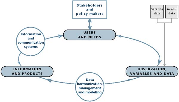
The structure of the C-GTOS system includes observations, variables and data, which are transformed into information and products to provide for users and their needs. In turn, users and their needs provide feedback influencing the further development of observations, variables and data. Each of these stages is dependent on additional components, shown in the white box and circles.
![]()
![]()
![]()