![]()
![]()
![]()
Paul Kiepe
Inland Valley Consortium, WARDA - The Africa Rice Center
Cotonou, Benin
Kiepe, P. 2006. Characterization of three key environments for integrated irrigation-aquaculture and their local names. In M. Halwart & A.A. van Dam, eds. Integrated irrigation and aquaculture in West Africa: concepts, practices and potential, pp. 1–6. Rome, FAO.181 pp.
Abstract
The paper provides a definition of wetlands and stresses the difference between wetlands as ecosystems and wetlands as production systems. The different classification systems available to refer to their specific usage are shown. Wetlands are defined as areas that are partly or completely inundated for some or all of the time. Tropical wetlands can be classified into four main groups: (coastal plains, inland basins, river floodplains and inland valleys). Inland valleys represent 36 % of total area covered by wetlands in sub-Sahara Africa; they are the upper reaches of river systems, in which alluvial sedimentation processes are almost or completely absent. The availability of a local classification of wetlands was is pointed out: local names can provide important and unexpected information in site-specific studies. There are however risks of mistranslating them as one local name may encompass several different wetland types as we know them. Bearing this in mind, local classification provides a valuable tool in describing integrated irrigation-aquaculture (IIA) locations. With particular regard to IIA in West Africa, three key environments encompass the majority of IIA systems: (1) irrigated systems, (2) floodplains and (3) inland valley bottoms.
Introduction
The common denominator of the three key environments for integrated irrigation-aquaculture (IIA) - irrigated systems, floodplains and inland valleys - is that they are all wetlands. However, classification and characterization of wetlands are problematic, because there are many classification systems. One of the conclusions of the FAO-sponsored “Wetland Development and Management (WEDEM) Workshop on Sustainable Inland Valley Use” in 1996 in Cotonou, Benin, was the lack of a common approach to classifying and characterizing wetlands. This conclusion was not new; the issue had been raised on several previous occasions and it was one of the factors motivating the launch of the Inland Valley Consortium (IVC) in 1993. A closer look at classification systems of wetlands that are relevant for this workshop may shed light on the matter.
Wetlands
Wetlands are areas that are partly or completely inundated for some or all of the time. They generally include swamps, marshes, bogs and shallow waters. Wetlands are site-specific, complex ecosystems and are critical to the survival of many communities throughout the world. Wetlands occupy about ten percent of sub-Saharan Africa (Table 1). There are two conflicting views about wetland management: one agricultural and the other ecological. From an agricultural point of view, wetlands are assumed to form the basis of robust production systems, less sensitive to degradation than the adjacent uplands due to the frequent inflow of water, nutrients and organic debris. On the other hand, ecologists regard the same wetlands as fragile ecosystems that should be handled with care. A distinction should therefore be made between a wetland ecosystem and a wetland production system.
Table 1. The extent of wetlands in tropical sub-Saharan Africa and proportion of wetland types in total wetland, arable land and total land area (Andriesse, 1986).
| Wetland type | Area | Proportion of wetland type | ||
| of total wetlands | of arable land | of total land | ||
| (km2) | (%) | (%) | (%) | |
| Coastal wetlands | 165 000 | 6.9 | 1.5 | 0.7 |
| Inland basins | 1 075 000 | 45.0 | 9.7 | 4.5 |
| River floodplains | 300 000 | 12.6 | 2.7 | 1.3 |
| Inland valleys | 850 000 | 35.6 | 7.7 | 3.6 |
Wetland ecosystems
The Ramsar Convention on Wetlands defines wetlands as “areas of marshes, fen, peat land or water, whether natural or artificial, permanent or temporary, with water that is flowing or static, fresh, brackish or salty, including areas of marine water the depth of which at low tide does not exceed six meters”. The Ramsar classification divides wetlands into three main categories:
The main categories have further subdivisions resulting in a total of about forty wetland types (Ramsar, 1999).
Wetlands have important ecological functions like water purification, groundwater recharge, carbon sequestration and protection against flooding and erosion. Wetlands also provide resting and nesting sites for many wildlife species. They can be regarded as a maternity ward and nursery for fish, amphibians, reptiles, birds and mammals, and are particularly important for shy and rare species.
Wetland production systems
The focus for this workshop is on wetland production systems. Wetlands have important economic functions like crop (e.g. rice) and vegetable production, as a source for thatching, fencing and basket weaving material, fishing and as a water source and grazing area for livestock in the dry season. While the Ramsar convention classified wetlands with the aim of safeguarding the biodiversity of sensitive ecosystems, agricultural research organizsations classify wetlands according to a number of other criteria, as described hereafter with a presentation of three existing classifications which are relevant to the three key environments selected in the context of this workshop for IIA development.
WURP classification of African wetlands
The Wetland Utilization Research Project (WURP), funded by the Dutch Government (DGIS) and executed by the International Institute of Tropical Agriculture (IITA) and the University of Wageningen in the early 1980s, had as its main objective the development of inland valley bottoms for wetland rice cultivation. The first phase of the WURP was an inventory of information to identify the extent and categories of wetlands in the humid and subhumid zones of West Africa (Windmeijer and Andriesse, 1993). Four major wetland types were distinguished, based on geomorphological considerations:
The extent of the four wetland types in Africa was estimated from extrapolation of the results from West Africa superimposed on the FAO soil map of Africa, as indicated in Table 1. WARDA classification of rice production environments
Table 2. Relative importance of rice production systems in West and Central Africa (WARDA, 1997).
| Rice production system | Area | Production |
| (%) | (%) | |
| Tidal water (mangrove swamps, coastal plains) | 4 | 4 |
| Deepwater or floating rice | 9 | 5 |
| Irrigated systems | 12 | 28 |
| Rainfed uplands | 31 | 25 |
| Rainfed lowlands | 44 | 36 |
WARDA (The Africa Rice Center) recognizes four major rice production systems in West Africa (Table 2):
Because the rainfed uplands, rainfed lowlands and irrigated systems account for the bulk of area and total production in western and central Africa, and because of their role in poverty reduction, priority was given to work in these three production systems. Relatively little direct attention was given to other systems such as mangrove and deepwater rice production, not because these systems were less important but merely because it was more resource-effective to concentrate on the three aforementioned production systems.
FAO classification
The FAO/World Bank Global Farming Systems Study recognizes eight different farming systems (Dixon and Gulliver, 2003):
The first three farming systems are relevant to rice-fish culture and coincide to a large extent with the three key environments selected for this workshop.
The IIA key environments
The classification used in the context of IIA development is:
This classification is thus based on a combination of geomorphology and water management considerations, as illustrated in Figure 1.
Irrigated systems
Irrigation can be described as the supply of land with water by means of artificial canals and ditches, to promote the growth of food crops. Irrigated systems are found in West Africa in inland basins, like the Senegal basin, the inner Niger delta, the Volta basin and along the floodplains of major rivers. Irrigation is about water supply on demand, independent of rainfall. Water retention by bunds without bringing in additional water, as often found in inland valleys, therefore cannot be considered as irrigation (Young, 1998).
Floodplains
A floodplain is ausually dry and relatively flat area of recent alluvial deposits alongside a stream or river and is subject to periodical inundation.Large floodplains are very suitable for irrigation, because they are more or less levelled, often fertile and close to a water source. Floodplain irrigation systems can be based on gravity, where water is delivered by a canal that runs upstream along the river to a point that allows water intake with sufficient pressure head. A disadvantage of these systems is that they depend on water level fluctuations in the river and intake may no longer be possible below a certain water level.
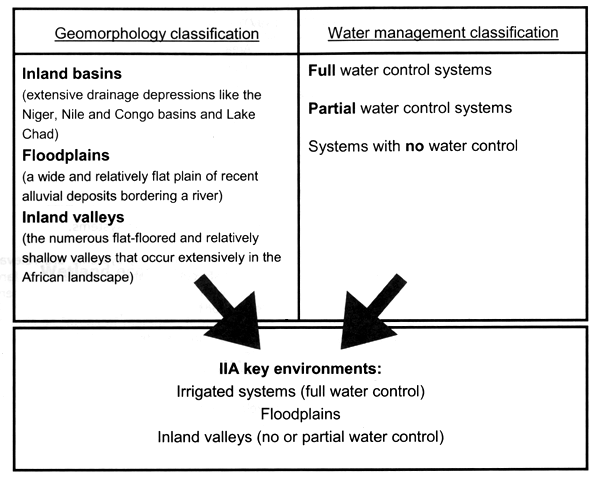
Figure 1. Classification of integrated irrigation-aquaculture (IIA) environments based on a
combination of geomorphology and water management considerations.
Inland valleys
Inland valleys are the upper reaches of river systems, in which alluvial sedimentation processes are almost or completely absent. Inland valleys include valley bottoms and minor colluvial floodplains, which may be submerged part of the year, their hydromorphic fringes and continuous upland slopes and crests extending over an area that contributes runoff and seepage to the valley bottom. The term partial water control is used for water retention by dikes or bunds in rainfed agriculture.
The classification chosen for IIA is pragmatic, as the three environments are not mutually exclusive. Full-control irrigation systems are often found in inland basins, but they are also encountered in floodplains or even in inland valleys. However, some confusion may arise regarding what to incorporate under the term “irrigation”. While full water control is evident, the area of “partial water control” is less well-defined.
Local classification of wetlands
Every rural population has its own interpretation and its own words for areas of specific interest. Local names, also called vernacular or indigenous names, often don't correspond to a formal scientific classification because they are based on other criteria. So, a word of caution must be expressed on the use of indigenous nomenclature. These problems may arise in inventories that are based on interviews with farmers. Any question posed in a local language that is related to a typology of the environment is likely to be answered with the vernacular name in the local language. Local names can provide important and unexpected information in site-specific studies, but if the objective is to relate the acquired information to a larger area, questionnaires should be designed to trace a category in a classification system and vernacular names should be used in such a way that they coincide with a unique category.
Some examples of indigenous wetland names
References
Andriesse, W. 1986. Area and distribution. In A.R.S. Juo & J.A. Lowe, eds. The wetlands and rice in sub-Saharan Africa. Ibadan, Nigeria, IITA , pp. 15–30.
Dixon, J. & Gulliver, A. 2003. Farm management systems and food production. Rome, Food and Agriculture Organization, 13 pp.
Mackel, R. 1985. Dambos and related landforms in Africa; an example for the ecological approach to tropical geomorphology. Z. Geomorphol. N.F. Supplementband 52: 1–23.
Ramsar. 1999. Classification system for wetland type. Key documents of the Ramsar Convention. Gland, Switzerland, Ramsar Convention Secretariat (available at http://www.ramsar.org/index_key_docs. htm).
Roberts, N. 1988. Dambos in development: management of a fragile ecological resource. Journal of Biogeography, 15: 141–148.
WARDA. 1997. Annual Report 1997. Bouaké, Côte d'Ivoire, WARDA The Africa Rice Center.
WARDA. 2003. Strategic Plan 2003–2012. Bouaké, Côte d'Ivoire, WARDA The Africa Rice Center, 56 pp.
Windmeijer, P.N. & Andriesse, W., eds. 1993. Inland valleys in West Africa: an agro-ecological characterization of rice growing environments. Publication 52, Wageningen, The Netherlands, International Institute for Land Reclamation and Improvement, 160 pp.
Young, A. 1998. Land resources: now and for the future. Cambridge, Cambridge University Press, 319 pp.
![]()
![]()
![]()