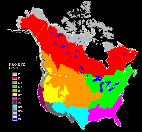
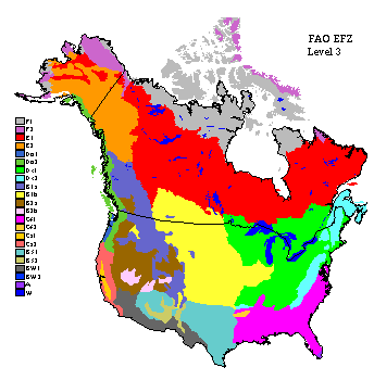
FAO level 1 |
FAO level 2 |
L2 code |
FAO level 3 |
L3 code |
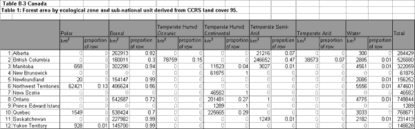
CEC Ecological Regions of North America (1997) |
USA Bailey’s Ecoregions of the United States (1998) |
|
1. Polar |
Polar |
F |
Plain |
F1 |
2.1: Northern Arctic 2.2: Alaska Tundra 2.4: Southern Arctic |
120: Tundra Division |
|
F |
Mountain |
F2 |
1.1: Arctic Cordillera 2.3: Brooks Range |
M120: Tundra Division – mountain provinces |
||
|
2. Boreal |
Boreal |
E |
Plain |
E1 |
3.1: Alaska Boreal Interior 3.3: Taiga Plains 3.4: Taiga Shield 4.1: Hudson Plains 5.1: Softwood Shield 9.1: Boreal Plains |
130: Subarctic Dvision, |
|
E |
Mountain |
E2 |
3.2: Taiga Cordillera 6.1: Boreal Cordillera |
M130: Subarctic Divison – mountain provinces |
||
|
3. Temperate |
Humid oceanic |
Do |
Plain |
Do1 |
240: Marine Division |
|
|
Do |
Mountain |
Do2 |
7.1: Marine West Coast Forests |
M240: Marine Division – mountain provinces |
||
|
Humid continental |
Dc |
Plain |
Dc1 |
5.2: Mixedwood Shield 8.1: Mixedwood Plains |
210: Warm Continental Division 220: Hot Continental Division |
|
|
Dc |
Mountain |
Dc2 |
5.3: Atlantic Highlands |
M210: Warm Continental Divison – mountain provinces M220: Hot Contientatl Divison – mountain provinces |
||
|
Semi-arid |
B1 |
Steppe/prairie plain |
B1b |
9.2: Temperate Prairies 9.3: West-Central Semi-Arid Plains 8.2: Cemtral USA Plains |
251: Parkland Prairie (Temperate) province 330: Temperate Steppe Division |
|
|
B1 |
Mountain forest/steppe |
B1a |
6.2: Westerm Cordillera |
M330: Temperate Steppe Divison – mountain provinces |
||
|
Arid |
B2 |
Desert plain |
B2a |
10.1:Western Interior Basin and Ranges |
340: Temperate Desert Division |
|
|
B2 |
Desert mountain |
B2b |
M340: Temperate Desert Division – mountain provinces |
|||
|
4. Subtropical |
Humid |
Cf |
Plain |
Cf1 |
230: Subtropical Division |
|
|
Cf |
Mountain |
Cf2 |
M230: Subtropical Division – mountain provinces |
|||
|
Summer dry |
Cs |
Forest/shrub plain |
Cs1 |
260: Mediterranean Division |
||
|
Cs |
Mountain |
Cs2 |
M260: Mediterranea Division – mountain provinces |
|||
|
Semi-arid |
BS |
Prairie/steppe plain |
BS1 |
310: Tropica/Subtropical Steppe Division |
||
|
BS |
Prairie/steppe mountain |
BS2 |
M310: Tropical Subtropical Steppe Division – Mountain Provinces |
|||
|
Arid |
BW |
Desert plain |
BW1 |
320: Tropcial/Subtropical Desert Division |
||
|
BW |
Desert mountain |
BW2 |
M320: Tropcial/Subtropical Desert Division – mountain provinces |
|||
|
5. Tropical |
Wet |
Ar |
Ar1 |
411: Everglades province |
||
|
Winter dry |
Aw |
|||||
|
Semi-arid |
||||||
|
Arid |
||||||
|
6. Water |
W |
W |
99 |
0 |
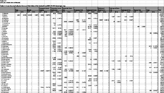
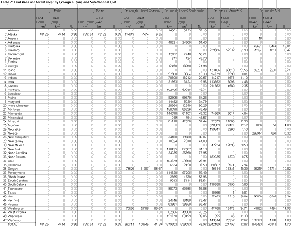
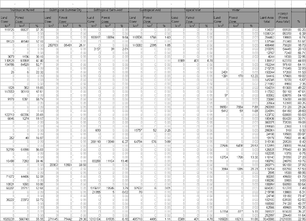
Table 2: continued