![]()
![]()
![]()
by
A.E. STARK
CSIRO Marine Laboratory
Cronulla, New South Wales, Australia
and
R.J. SLACK-SMITH
Department of Fisheries and Fauna
Perth, Western Australia
Abstract
To estimate the potential of a fishery, collation of several types of information is needed. These are: (i) size of the resource and its fluctuations; (ii) cost of fishing the resource and of subsequent marketing; and (iii) prediction of market demand conditions.
For an unexplored and unexploited fishery it is proposed that the survey be broken into two distinct phases: (i) exploratory fishing; and (ii) full-scale resource survey.
Idealization of surveys is discussed and methods of determining “surfaces of abundance” investigated.
Factors causing changes in distribution of areas of abundance and the relevance of these changes to survey design are also discussed. In the case of prawn resource surveys, these include: diurnal, within and between season variations; growth; migration; removal by fishing; and behaviour.
The need for comprehensive planning and strict adherence to the plan during the survey is stressed.
OBSERVATIONS GENERALES SUR LE PLAN, L'ANALYSE ET L'EVALUATION DES ENQUETES SUR LES RESSOURCES MARINES
Résumé
L'évaluation du potentiel d'une pêcherie, exige l'exploitation de plusieurs types de renseignements, portant sur les points suivants: i) importance et fluctuations de la ressource; ii) coût de la pêche de cette ressource et de la commercialisation ultérieure; iii) prédiction des conditions de la demande commerciale.
Pour une pêcherie non prospectée et inexploitée, on propose de procéder à l'enquê te en deux phases distinctes : i) pêche exploratrice; ii) enquête à grande échelle sur les ressources.
La communication traite de l'“idéalisation” des enquêtes, et étudie les méthodes servant à déterminer les “surfaces d'abondance”.
Les auteurs examinent également les facteurs provoquant des modifications dans la répartition des zones d'abondance et l'importance que revêtent ces modifications pour l'établissement du plan d'enquête.
Enfin, la communication insiste sur la nécessité d'organiser le travail de façon approfondie et de respecter scrupuleusement le plan durant l'enquête.
OBSERVACIONES GENERALES SOBRE LA PREPARACION, ANALISIS Y EVALUACION DE LOS ESTUDIOS SOBRE LOS RECURSOS MARINOS
Extracto
Para calcular el potencial de una pesquería se necesita recoger varios tipos de información, a saber: (i) volumen del recurso y sus fluctuaciones; (ii) costo de la pesca del recurso y de su comercialización posterior y (iii) pronóstico sobre las condiciones de la demanda del mercado.
Para una pesquería sin explorar y sin explotar se propone que se distribuya el estudio en dos fases distintas: (i) pesca exploratoria y (ii) estudio del recurso a escala natural.
Se discute la idealización de los estudios y se investigan los métodos de determinar las “superficies de abundancia”.
Se examinan igualmente los factores que ocasionan cambios en la distribución de las zonas de abundancia y la importancia que tienen estos cambios para la preparación del estudio.
Se insiste en la necesidad de realizar una planificación general y de seguir estrictamente el plan durante el estudio.
To judge whether an area contains a potential fishery, several kinds of relevant information must be collated: firstly, the present size of the resource must be estimated: secondly, the costs involved in exploiting the resource and marketing the catch must be worked out, and, thirdly, the demand for the product must be forecast.
In this paper we shall be concerned only with estimating the distribution and current size of the resource. We shall discuss the shape of what we call the “surface of abundance”, which is defined in greater detail below, but briefly denotes the spatial distribution of the resource. It is not proposed to discuss fully the practical details of a resource survey. Gulland (1962) has already given and excellent account of the sampling problems and techniques involved, and, although no attempt will be made to duplicate his work, it is inevitable that some of the same ground will be covered. The aim is simply to assist in the development of a set of concepts which may be useful to fisheries scientists engaged in planning resource surveys.
Initially, information on an unexplored and unexploited resource is sought from published literature and other sources of information. The latter may be in the form of unpublished reports, casual observations or even verbal reports from fishing skippers or mariners. Answers to the following questions should be sought: What is known of the physical, chemical and biological characteristics of the proposed survey area? What commercially important species are likely to be present? What are the habitat preferences of these species? If answers to the above questions are found, then it is possible to predict which portions of the total area are most likely to sustain a fishery.
2.1 Exploratory surveys
Usually, as adequate biogeographical and environmental data are not available, exploratory fishing is necessary to make the above predictions and to determine whether a full-scale survey is warranted. During exploration data collected are not usually sufficiently detailed to estimate the absolute size of the resource. These will merely point to the presence of certain commercial species and give some indication of the extent of their habitat. Gear for exploratory fishing, and indeed for survey fishing generally, should be selected to make the most efficient use of sampling time rather than to take high catches. For example, in the search for potential prawn fisheries, try-nets are preferable to commercial nets as they are more easily shot and hauled. Sampling frequency is thus increased. The area to be explored should be selected so that it can be sampled adequately with the survey equipment available, thus ensuring that meaningful results are obtained and that sampling over a large range of habitat types can be carried out.
Under suitable conditions of supply and demand for the product, demonstration of the presence of the resource will often be sufficient to induce commercial fishermen to enter the area. On the other hand, the results of an exploratory survey may be insufficient to attract industry into a particular area. If the survey authority believes that a potential fishery exists and it is desirable that industry be induced to exploit the resource, a full-scale survey should be commenced.
2.2 Full-scale resource surveys
The purpose of the full-scale survey is to determine the extent of the grounds and the variations in fish density over the grounds at different times and circumstances. It is particularly important that uncalibrated gear should not be used during this phase of the survey and that the fishing power of the vessel should not change. If such changes occur, there is a tendency for these to be confounded with variations within the population, often making comparisons between times and areas erroneous. If it is considered essential that different gear be used, then the new gear should be calibrated against the known gear in properly designed trials.
Careful planning is essential to achieve maximum efficiency. It is necessary to consider the following questions prior to detailed planning: How much work can be expected from available vessels, gear and staff? What is the variability of results from the sampling technique to be used, e.g., trawl-nets, longlines, traps, etc.? What data are to be collected and which design is most suitable for recording sheets? If computer analysis is anticipated, then sheets should be designed to simplify preparation of data for presentation to the computer.
An integral part of a resource survey is the collection of biological and environmental information during fishing. This assists in assessing the potential of the fishery and makes the current survey more efficient. Before deciding what information is to be collected, we must consider what biological or environmental questions require answers. Such questions may include: When and where are the fish at the most preferred size for marketing? Are there any parasites present that may cause market resistance? If the fish are migratory, what are the seasons of occurrence in the survey area and what is the path and rate of migration from the area? How does the occurrence or vulnerability of the fish vary with changes in the physical, chemical or biological environment?
Extreme caution should be exercised in the collection of data that is ‘interesting’ or ‘may be useful later’. These data are often left unused until they become outdated.
At best, surveys measure only the standing crop, and are not sufficiently comprehensive to make predictions of the dynamic response of the population to fishing. Nevertheless, collection of data required for the estimation of sustainable yield should be commenced at this stage and continued from commercial fishing units as these commence operations.
In this section we shall use an idealized survey to establish terminology and to set up criteria for designing, analyzing and evaluating resource surveys. We shall assume that the unknown distribution of the resource could be represented approximately by a smooth ‘surface of abundance’ (Fig.1). We assume that the aim of the survey is to estimate the shape of this surface by sampling over some grid of points superimposed on the space occupied by the resource. To make the model more realistic, we shall also assume that there are small-scale variations of density throughout the surface of abundance and that our sampling instrument will make errors of measurement which we cannot distinguish from such deviations in density.
If we first set up our grid over the whole space without reference to any prior knowledge of the distribution of the resource, we shall, in principle, be able to form an unbiased picture of the whole surface. Moreover, if the number of sample points is large enough to cope with deviations and error of measurement we shall form an accurate picture. Without going into the technicalities of procedure, we would construct this picture by using some objective method of surface fitting such as the method of fitting polynomials by least squares or by manual contouring methods. Computation of relative abundance would be consistent with the contouring procedure and derived by estimating the ‘volume’ of resource lying below the surface.
At the present level of technology, it is usually not possible to state precisely the area of effect (swept area) of a single operation of the particular sampling or fishing gear being used, nor is it possible to say exactly what proportion of animals within the area of effect are enumerated or removed by each operation of the gear. It is usually assumed that the swept area of a unit operation is constant and that the proportion of animals captured with it is also constant. If these assumptions are nearly true then the sampling procedure and method of surface fitting will yield a close approximation to the shape of the surface of abundance. Contours of abundance at different points in the space will then give relative measures of abundance. It is necessary to calibrate the sampling gear in some way to convert these to absolute measures. This conversion is far from simple, and may be complicated by variations in the behaviour of the fish in relation to the gear, so that the catch per unit of effort does not bear a constant relation to absolute abundance.
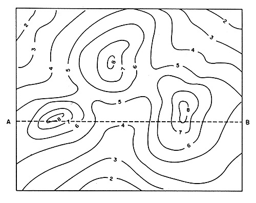
Fig. 1 Contoured representation of a hypothetical surface of abundance of a resource.
A multi-phase strategy is frequently the most efficient. We use a two-phase version of our idealized survey to illustrate this concept. Suppose that in the first phase our grid of sample points is uniformly spread over the whole space. In addition to recording the count or weight of animals, we record also a number of other characteristics at each point. It may then be possible to draw contours describing the distribution of these other variables. As a simple example, we may find from the first phase that the type of bottom may be classified broadly into two types and that the density of fish is relatively high on type A and low on type B. We may then decide that in the second phase we shall sample more intensively over areas of type A to chart more accurately the abundance of animals there.
The above procedure may be contrasted with that of a commercial fisherman just starting to trawl a new ground. His strategy might be as follows. He first makes a trawl shot completely at random. If this yields good results he marks the area with a buoy and fishes around it till the catches fall. If the first shot is unsatisfactory he moves some distance away and trawls again. We may analyze the charactoristics of such an operation with the aid of idealized resources. We first plot the assumed distribution of resource (Fig. 2) along the section AB from Fig. 1. We postulate that the deviations from the surface tend to be such that if we sample at two closely spaced points the deviations will be similar but that as the points are more widely-spaced the correlation diminishes. Our sampling strategy described earlier leads us to take samples at points x0, x1, x2, etc., at which spacings the correlation between deviations is negligible and we form a good picture of the shape of the surface along AB. The result of the fisherman's strategy (Fig. 3) may be shown in an enlarged view of section x2 to x5 of Fig. 2, illustrating the postulate about deviations from the surface stated above. Suppose the fisherman trawls at one of the points corresponding to the set of small circles and decides that the catch is too low. He moves on and by chance reaches a position corresponding to one of the set of crosses. He may then make several shots until the catch rate falls. Thus he will tend to make several shots wherever he finds a high level of abundance and only one at low levels. This point is of great importance when one is comparing catch rates of a survey vessel fishing on a preselected grid of points and a fishing vessel following the strategy just described. It is to be expected that a fisherman's overall catch rate will always be higher than that of a survey vessel.
The survey method described yields an estimate of relative abundance over the whole space, but it is virtually impossible to do this from a fisherman's results. This is not a condemnation of fishermen's methods, of course, but is mentioned merely to illustrate the different results which should be inferred by studying two sets of data.
Having established the broad shape of the surface of abundance, it may then be thought desirable to induce fishermen to enter the survey area by obtaining maximum survey vessel catches using fishermen's methods. It is important when studying these latter data to know the strategy of operations which produced them. Alternatively, it may be useful to employ a ‘mixed strategy’ of surveying, i.e., the survey vessel follows a systematic grid of stations, but, if a good catch is observed at any station, a number of follow-up shots are made at that spot before the unit moves to the next station.
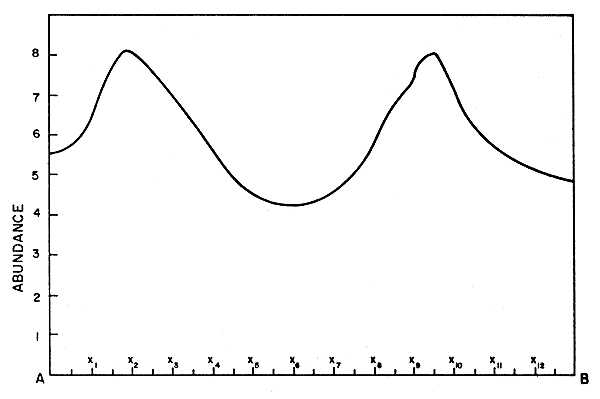
Fig. 2 Profile of surface of abundance along section AB of Fig. 1.
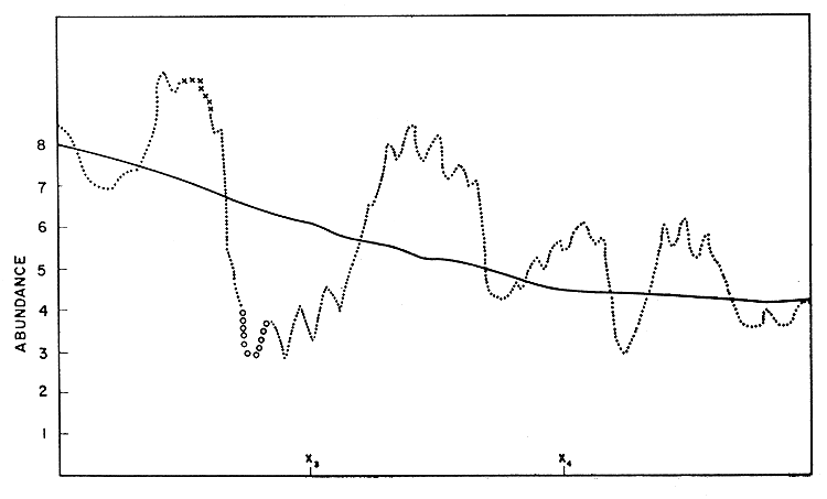
Fig. 3 An enlarged view of segment x2, x5 of Fig. 2.
In general, the surface of relative abundance of a resource will change in shape and absolute size from one instant of time to the next. It may, for example, have a slow long-term trend, underlying periodic fluctuations of varying frequencies, phases and amplitudes. A trend may be associated, for example, with slow environmental changes such as progressive pollution. Periodic fluctuations may relate to annual cycles of reproduction, growth, migration, etc. Apparent periodic fluctuations may be due to varying responses of the population, or some members of it, to the operations of the fishing unit, so that while the actual size and distribution of the population remain constant, they may appear to change. The surveying equipment may also be subject to outside influences, e.g., rough weather may affect fishing efficiency.
To illustrate the way in which several types of biological and behavioral factors affect the distribution of abundance (or apparent abundance) we can examine the results of various research programs in Shark Bay (Slack-Smith, in press; Slack-Smith and Stark, in press).
A factorial trawling experiment was carried out to examine the variability of trawling results in a restricted area. Lunar and diurnal changes were the variates considered. Four daily periods and four lunar periods were used on four adjacent randomized blocks. It was observed that catches of both king prawns (Penaeus latisulcatus Kishinouye) and tiger prawns (P. esculentus Haswell) were significantly greater during the hours of darkness and at the time of the new moon. It is unlikely that changes in actual abundance occurred, but probably that these variations were due to catchability changes. This indicates that before any meaningful comparisons could be made between trawling results from different areas, these cyclic variations must be eliminated.
Violent annual fluctuations in penaeid recruitment are well known, and these, as well as variations of time of recruitment within the year, must also be considered when a trawling survey is being planned or the results analyzed.
Further sources of variation to be considered include the rapid growth and high mobility of these animals. Both affect the distribution and abundance of prawns quite markedly. Every endeavor should be made to account for all such sources of variation when surveys are being planned.
What has been written perhaps adds weight to what is already well-known: that the planning of an effective resource survey is a very complex operation. It is therefore worthwhile to see whether there exists any established body of methodology which would aid planning, even if only with respect to general principles rather than to details. We believe that some of the methods devised for studying response surfaces and the general theory of statistical designs underlying these methods are relevant. An account of these techniques can be found in Davies (1954). Clearly, the situations for which these methods were developed are much simpler than those facing the scientist who is charting wild populations, but the concepts are valuable. A brief outline of response surface concepts will show the similarities.
Much of the work on response surfaces has been done in connection with problems arising in the chemical industry, where manufacturers have wanted to find, for example, the levels of several imput factors which will produce the optimum yield of a product. It is postulated that the yield or response is a function of several quantitive factors. A typical example of such a yield surface is shown in Fig. 4 and represented by contours in Fig. 5. An obvious method of finding the shape of this surface would be to make observations corresponding to a grid of points spread over the time-concentration space. A contour surface in a three-dimensional factor space is shown in Fig. 6. Its shape also could be studied by taking observations over a grid of points in the whole factor space.
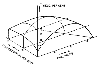 | Fig. 4 A typical yield surface |
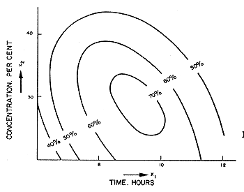 | Fig. 5 Yield contours for surface shown in Fig. 4 |
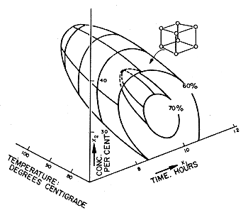 | 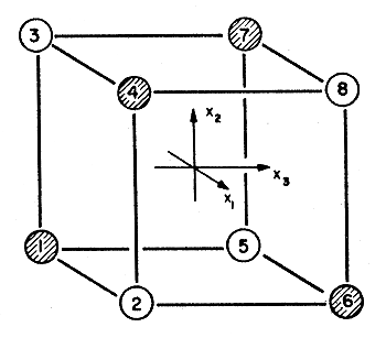 |
Fig. 6 Contour surfaces in a 3-dimensional factor space with a 23 factorial design (after Davies, 1954). | Fig. 7 A 23 factorial design showing the division into half-replicate designs (after Davies, 1954). |
The similarity between a surface of abundance (our earlier idealization) and yield or response surfaces, will now be apparent. The population density of animals corresponds with yield, and the spatial, time and biological variables correspond with the factors determining yield. In most response surface studies, the object is to locate the co-ordinates of the maximum of the surface rather than to chart the whole surface. Thus the two contrasting aims correspond respectively with those of the fisherman and the scientist charting the surface of abundance. Nevertheless some of the concepts for determining the maximum of the response surface, in particular the use of fractional factorial experimentation, are useful for the wider problem of charting the shape of the whole space. Davies (1954: 507) shows how a two-level fractional factorial design can be used to find the slope of the surface over a small region of the factor space. The cube of points is shown in miniature in Fig. 6, and in detail in Fig. 7. This gives the two possible experimental designs. The point of interest here is that it is not necessary to carry out the full factorial array of observations to give the required answer.
We do not pretend that survey planning can be simplified to the extent suggested by this discussion, but we do suggest that survey efficiency would be greatly enhanced if an attempt were made to incorporate some of these concepts.
Gulland, J.A., 1962 Manual of sampling methods for fisheries biology. FAO Fish.Tech. Pap., (40) Revision 1: 66 p.
Davies, O.L., 1954 Design and analysis of industrial experiments. London, Oliver and Boyd, 636 p.
Slack-Smith, R.J., (in press) The prawn industry in Shark Bay, Western Australia. Paper presented to FAO World Scientific Conference on the Biology and Culture of Shrimps and Prawns, Mexico, 12–21 June, 1967.
Slack-Smith, R.J. and A.E. Stark, (in press) Automatic processing of Western Australian prawn fishermen's log books. Paper presented to FAO World Scientific Conference on the Biology and Culture of Shrimps and Prawns, Mexico, 12–21 June, 1967.
Acknowledgments
Mr. A.J. Fraser, Dr. R.G. Chittleborough and Mr. B.K. Bowen read the manuscript and Mrs. E.H. Barker prepared the figures.
![]()
![]()
![]()