![]()
![]()
![]()
| Rf Page | Cat. | Date | Water Inlet | Sd CM | Pond No. | Tem °Cel | pH | Total Area M2 | Altitude M | Latitude | Longitude | Cq |
| 8 | IFF | 4/7/96 | 5 | 18 | 2 | 31 | 6.5 | 375 | 1316 | 00°06'22"N | 034°29'55E | 6 |
| 9 | IFF | 4/7/96 | 5 | 20 | 7 | 28 | 7.0 | 496 | 1426 | 00°05'56"N | 034°30'32E | 7 |
| 10 | IFF | 4/7/96 | 5 | 30 | 1 | 28 | 7.0 | 378 | 1231 | 00°06'37"N | 034°30'53E | 7 |
| 13 | IFF | 5/7/96 | 5 | 39 | 4 | 27 | 7.0 | 941 | 1190 | 00°20'35"N | 034°08'33E | 8 |
| 15 | AFFG | 5/7/96 | R | 25 | 3 | 29 | 7.5 | 1014 | 1229 | 00°17'54"N | 034°06'52E | 9 |
| 17 | AFFG | 5/7/96 | G | 30 | 5 | 22 | 7.5 | 1455 | 1020 | 00°15'44"N | 034°05'40E | 9 |
| 21 | IFF | 8/7/96 | P | 15 | 5 | 26 | 8.5 | 500 | 1500 | 00°23'32"N | 034°00'45E | 8 |
| 28 | IFF | 9/7/96 | R | 16 | 3 | 25 | 8.5 | 1080 | 1368 | 00°45'37"S | 034°35'53E | 9 |
| 29 | IFF | 9/7/96 | R | 18 | 1 | 25 | 8.0 | 700 | 1443 | 00°45'24"S | 034°35'31E | 9 |
| 30 | IFF | 9/7/96 | 5 | 40 | 5 | 27 | 7.0 | 1879 | 1543 | 00°56'38"S | 034°32'30E | 9 |
| 32 | IFF | 9/7/96 | 5 | 40 | 2 | 24 | 6.0 | 250 | 1386 | 00°59'15"S | 034°30'15E | 9 |
| 33 | IFF | 9/7/96 | R | 20 | 4 | 26 | 7.6 | 600 | 1354 | 00°59'20"S | 034°31'03E | 9 |
| 35 | AFFG(W) | 9/7/96 | R | 20 | 6 | 26 | 7.0 | 2780 | 1367 | 00°59'53"S | 034°32'34E | 9 |
| 40 | IFF(W) | 10/7/96 | S+6 | 30 | 5 | 21 | 5.7 | 976 | 1385 | 00°41'36"S | 034°41'03E | 9 |
| 41 | FFG(W) | 10/7/96 | S+6 | 40+ | 5 | 25 | 6.0 | 1476 | 1653 | 00°40'45"S | 034°43'49E | 9 |
| 45 | FFG(W) | 10/7/96 | S+6 | 40+ | 3 | 24 | 6.0 | 620 | 1616 | 00°40'37"S | 034°43'30E | 9 |
| 46 | FFG | 10/7/96 | S | 40+ | 2 | 20 | 7.5 | 414 | 1377 | 00°39'34"S | 034°42'12E | 9 |
| 50 | AFFG(W) | 11/7/96 | S | 25 | 5 | 21 | 6.0 | 879 | 1850 | 00°44'16"S | 034°53'33E | 7 |
| 51 | AFFG(W) | 11/7/96 | S | 20 | 2 | 21 | 6.5 | 125 | 1876 | 00°44'16"S | 034°53'34E | 8 |
| 52 | AFFG(W) | 11/7/96 | S | 20 | 4 | 25 | 7.5 | 1028 | 1947 | 00°44'29"S | 034°54'22E | 8 |
| 54 | IFF | 11/7/96 | S | 18 | 3 | 26 | 8.0 | 744 | 1930 | 00°43'34"S | 034°55'39E | 8 |
| 58 | AFFG | 12/7/96 | S+R | 17 | 7 | 25 | 7.0 | 1515 | 1733 | 00°07'42"N | 034°53'14E | 9 |
| 63 | AFFG | 15/7/96 | S | 21 | 4 | 29 | 7.0 | 677 | 1491 | 00°17'38"N | 034°44'53E | 9 |
| 65 | AFFG(W) | 15/7/96 | S | 27 | 2 | 25 | 7.5 | 360 | 1396 | 00°18'07"N | 034°45'16E | 7 |
| 66 | AFFG | 15/7/96 | S | 20 | 6 | 24 | 8.0 | 1384 | 1460 | 00°19'54"N | 034°41'31E | 9 |
| 71 | IFF | 16/7/96 | S | 18 | 7 | 26 | 7.0 | 2916 | 1630 | 00°46'57"N | 034°43'41E | 9 |
| 74 | IFF | 16/7/96 | S | 40 | 3 | 24 | 6.0 | 555 | 1460 | 00°37'31"N | 034°32'18E | 7 |
| 75 | AFFG(Y) | 16/7/96 | S | 20 | 6 | 26 | 7.5 | 2640 | 1403 | 00°35'44"N | 034°33'49E | 8 |
| 80 | IFF | 20/7/96 | R | 30 | 3 | 21 | 6.5 | 4232 | 1812 | 00°07'55"N | 034°56'04E | 9 |
| 82 | AFFG | 20/7/96 | R | 20 | 8 | 25 | 8.0 | 950 | 1663 | 00°07'01"N | 034°52'51E | 9 |
| 83 | AFFG | 20/7/96 | S | 30 | 3 | 25 | 7.0 | 1850 | 1719 | 00°06'32"N | 034°52'50E | 7 |
| 31 SITES | 125 | 35789 | ||||||||||
| A | 71%S | 26 | 4 | 1154 | 1510 | |||||||
| A2 | 1 | 284 |
Category of Fish Farmer
| IFF | = Individual Fish Farmer |
| AFFG | = Advanced Fish Farmer Group |
| (W) | = Women |
| (Y) | = Youth |
Water Inlet
| S | = Spring |
| R | = River |
| G | = Ground water |
Other Items
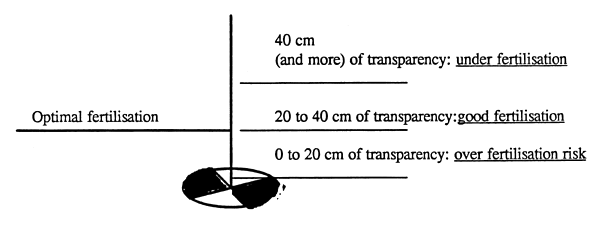
| SD | = Transparency with Secchi Disk (in cm) as indicator for fertilisation level evaluation in ponds as following: |
| Q | = Quality of information collected from Global Positional system from 0 (bad) to 9 (very good) Information collected on GPS |
![]()
![]()
![]()