![]()
![]()
![]()
THE MANAGEMENT OF TROPICAL WATERSHEDS
Sir H. Charles Pereira, FRS
Consultant in Tropical Agricultural Research and Land-Use Hydrology Kent,
England
SUMMARY
The same hydrological processes researched for watersheds in the Temperate Zone also operate in the tropics, where the higher inputs of energy result in more extreme hydrological cycles. Field studies of tropical watersheds, using combined budgets of energy and water, have already permitted the calibration of predictive computing models for streamflow.
Floods and droughts are intrinsic climatic features characteristic of the Inter Tropical Convergence Zone. Both can be alleviated by good land use. This also controls the flow of sediment and debris, thus protecting the long term investment in reservoirs which can control all but the most extreme floods.
Tropical mountain watersheds with both high rainfall and temperatures permitting all year round plant growth show ecological advantages for forests or for tree crops. Many well engineered estates where tea, rubber, cocoa, or oil palm replaced forest have demonstrated for more than a century the stable control of soil and water regimes. Paired-valley (catchment or watershed [ed.1) experiments in tropical Africa have demonstrated that with skilled development both tea estates and pine plantations could be hydrological equivalent to natural forests.
An urgent tropical problem is the invasion of forest lands in steep upland watersheds by subsistence farmers, cropping without replacement of nutrients and destructive overgrazing by uncontrolled livestock.
Acute and widespread shortages of fuelwood in most countries of Asia and of Africa provide a vast lowland market which offers opportunities to restore mountain watersheds to productivity and to provide employment by the replanting of steep wastelands. Here economics and ecology are complementary.
Viable systems are based on growing both fuel and fodder as crops rather
than free goods, restraining livestock by tethering or by stall feeding.
Improvements in land use can reduce the present unnecessary poverty and
resource destruction, but can only buy time while governments achieve
stabilization of population numbers. Science offers no land use policies
which will sustain continuation of present growth rates of tropical populations.
INTRODUCTION
We all live at some point in a watershed so that, if interpreted literally,
this title would embrace all land-use problems in the tropics, and would
be beyond the scope of a single paper. However, for an audience concerned
principally with forestry, the watershed management we are concerned with
is that of the forested areas, or of areas which could usefully bear trees.
We need to consider the environmental role of forests, especially their
hydrological effects and their importance as sources of clean water, fuel,
fodder and minor forest gatherings as well as of major commercial timber
crops.
All parts of a watershed are inescapably linked together by the behavior
of the river. Wise land-use in steep headwater valleys can reduce flood
dangers to the larger communities downstream, while misuse of the steep
lands can intensify floods bringing damage and misery to those below.
The capital to build roads and to provide education and medical services
for hill populations is usually generated by commercial and industrial
enterprises in the valley bottoms and plains.
This concept is not yet adequately recognized in the political philosophies
of many developing countries in the tropics. It was, indeed, of only minor
concern while populations were small and the more remote streamsource
areas were under dense cover of undisturbed forests. Extremely rapid growth
of populations throughout the tropical latitudes in the past three decades
has sharply increased the scale of watershed management problems. The
role of forests and the responsibilities of foresters are, all to slowly,
receiving increased recognition. Penalties for misuse of hill lands are
paid on an increasing scale throughout tropical river systems. In some
countries management of watersheds is already becoming an urgent matter
for national action, but the basic facts are not yet widely understood.
The "state of the art" is reviewed in this paper from the aspects
of most concern to forestry staff with responsibilities for watershed
management.
FORESTS AND CLIMATE
The Inter-Tropical Convergence Zone
The aspects of climate which dominate watershed management in the tropics are the great input of solar energy and the characteristic irregularity of rainfall. In comparison with the higher latitudes, radiation produces warmer temperatures which greatly enhance the growth rates of vegetation, but also, through greater evaporation rates, increases the intensities of droughts. Erratic and unpredictable droughts are, inescapably, a feature of the Inter-Tropical Convergence Zone (ITCZ), which is the broad trough of unstable, low-pressure moist air which results from the convergence of the Trade Winds from the northern and southern hemispheres. The ITCZ fluctuates seasonally across the Equator, following the sun, not as a continuous trough but with an irregular and turbulent pattern which produces an erratic incidence of rainfall. Some meteorologists prefer the term "Intertropical Confluence" (Barry and Chorley, 1982). In addition to the solar radiation input there are major releases of latent energy as vast masses of water vapor, evaporated from warm tropical oceans, condense into rainfall. Storms are characteristically heavy and rainfall intensities are high. Flood and drought incidence are therefore unalterable climatic characteristics of the broad tropical belt dominated by the ITCZ.
Flows of moist air are lifted by mountains or high hills to altitudes at which cooling and condensation produce rainfall. In the tropics, where the hill slopes remain warm, the combination of high temperature with high rainfall characteristically produces the vigorous growth of tropical closed forest.
The Influence of Forests on Rainfall
The foresters of the 19th century believed that the presence of the forest itself caused an increase in rainfall. They used this argument sincerely to defend their forests against invasion and destruction. Scientific study of the atmosphere was not then capable of testing this theory, which was enshrined in the early forestry textbooks. Today we are used to seeing satellite photographs of the world's weather systems, with vast swirling patterns of convergence generating rainfall on a scale several orders of magnitude greater than that of the forested areas. The scale of these atmospheric processes is such that only the oceans present evaporation surfaces large enough to provide sufficient water for continental precipitation.
Over the continents of Asia (Budyko, 1958) and North America (Benton et al.,. 1950) meteorological studies conclude that some 90% of the precipitation is of water evaporated from ocean surfaces. Studies of continental circulation over the Amazon forest have begun (Salati et al., 1980) but as yet the daunting lack of data over this vast area makes conclusions speculative. In the drier tropical areas such as East Africa, where ecological patterns are ruled by water supplies, an interesting result of the erratic behavior of the ITCZ is that the boundaries of the ecological zones agree far more closely with the maps of rainfall reliability in 4 years out of 5 than with the maps of the average annual totals (Glover et al., 1954). Thus forests occur where there is adequate rainfall to support them.
The Cooling Effects of Forests
Although forests have not been found to cause or attract rainfall, they do have a pronounced cooling effect which increases the occurrence and persistence of mists. Pereira and McCulloch (1960) showed that the heat flux from tropical closed forest in East Africa in the dry season was about half of that emitted from land under subsistence crops and rough pasture (Table 1). The evaporation of water from the foliage, either by transpiration of water extracted from the soil or by direct evaporation of water intercepted from rainfall, cools the air around the forest canopy. This often results in mists, which are of frequent occurrence in forested areas.
Table 1. Average daily heat flux from East African land surfaces under different landuses in the dry season (Pereira and McCulloch, 1960).
| Country: | Tanzania | Tanzania | Kenya | Kenya |
| Land Use: | Semi-arid Grassland |
Subsistence Food Crops |
Bamboo Forest |
Dense Rain-Forest |
| Location: | Kongwa Ranch |
Mbeya Range |
Aberdare Mountains |
Sitoten Mountain |
| Latitude/: /Longitude: |
6°02'S/ /36°20'E |
8°49'S/ /33°22'E |
0°14's/ /36°45'E |
0°20'S/ /45°20'E |
| Altitude (m): | 1100 | 2500 | 3000 | 2300 |
| Rainfall (mm) | 500 | 1375 | 2500 | 1770 |
| Average Daily Heat Flux (gm.cal/cm² ): |
440 | 423 | 263 | 227 |
The Reception of Rainfall
The most important effect of forests on rainfall is on its reception and disposal. Under closed canopies forests provide complete physical protection for the soil surface against the impact of the violent tropical rainstorms of the ITCZ. The canopy intercepts rainfall and provides temporary storage in water films over the very great surface area of the foliage. Further "detention storage" is provided in the coarse pore space of the forest litter, which forms a layer of decomposing organic matter of 100mm to 300mm depth. The surface soil also provides temporary storage in the many holes made by the actions of roots and of soil fauna. Delay by this temporary storage smooth out the intensive rainstorm peaks so that the water is delivered to the stream channels in a more regulated flow. Water flowing from undisturbed forest is often discolored by organic matter, but the soil is completely protected. In steeply sloping stream channels the high velocity of streamflow may cause some bank-cutting and transport of soil, but tree roots provide strong reinforcements to the banks of forest streams. In flat terrain forests provide resistance to overland flow, but trees have to be cleared from drainage lines, which may be seriously obstructed (e.g., by willows in New Zealand and by tamarisks in the USA). Thus the forest, maintained by the orographic effects of high hills or mountains, serves to stabilize and protect the soil on the steep slopes. Both forest cover and soils have evolved together. The favorable conditions of water supply and temperature have also enabled tropical forests to develop on areas of marginal fertility or of extremely steep topography. If the forest cover should be destroyed on such sites, its re-establishment is difficult and slow.
FORESTS AND HYDROLOGICAL PROCESSES
The Hydrological Cycle
The hydrological. Cycle is summarized, usually on an annual basis, by the equation:
Precipitation = Streamflow + Evaporation (Evapotranspiration) ± Changes in storage of soil moisture and of groundwater
Usually denoted by:
P = Q + E ± S ± G
Each term in the equation represents the result of a complex of natural processes, so that none of them are easy to measure in the field on a watershed scale. Progress in the understanding of these processes and of their quantitative relationships has been substantial over the past three decades. Digital recording and computing have made possible the acquisition, storage and analysis of ever-increasing volumes of data. Improved technology places even more emphasis on the importance of competence and reliability of the measurements in the field, and needs careful adaptation for use in the tropics. Apart from the problems of designing electronic equipment to work at the high temperatures, humidities, and insect populations of tropical watersheds, such instruments usually require a higher standard of training of field staff. Training has been made available in many organizations, but the results have been disappointing in practice, since individuals with such specialized training seek jobs in towns and are rarely prepared to serve in remote hill stations where hydrological and meteorological methods are of most critical importance for flood warning and watershed management.
Precipitation (P)
The raingauge is a deceptively simply device. Even the obvious need to avoid screening of gauges by buildings or by trees is sometimes ignored. In the tropics trees grow fast and I have seen gauges, sited originally by meteorologists, subsequently overtopped by ornamental trees. In steep rugged country research workers have tried to use gauges set parallel to the slope. At sites exposed to strong winds raingauges have been set in shallow pits. To avoid splash from the ground surface raingauges have been surrounded by grids of "egg-box" design. Although useful in research, these elaboration are not necessary for raingauging needed for watershed management. There are, however, some important rules when setting out raingauges in a watershed. A useful principle to ensure that you have enough gauging points is to start with too many and find by arithmetic from the first year's records how many can be eliminated without significantly altering the mean.
Where the valley has a steep slope or the vegetation suggests a rainfall gradient it is useful to divide it into three or four horizontal strata with at least two gauges in each. It is then possible to eliminate statistically the differences due to gradient from those due to error. In a watershed experiment in East Africa, placing two gauges in each of three such horizontal strata halved the standard error of the mean catch for the valley. In a subsequent land-use change the valley was cleared and an additional 15 gauges were set up. They gave the same average as the original six.
Strict randomization is often impractical and, from experience, accessibility from a footpath or jeep track is of great importance for long-term reliability of routine readings. As the pioneer American forest hydrologist Charles Hursh said 50 years ago about the watershed studies at Coweeta "Watershed raingauges depend on dedicated men" but it makes sense to avoid placing gauges at strenuously inaccessible sites.
When computing the records, remember the intensive thunderstorms which we have all seen in which a few hectares get much more than the land on either side of the track of the storm. The standard Thiessen Polygon method does some useful correction for this effect.
Finally, if you are setting up raingauges for watershed monitoring for management purposes rather than for intensive research you will be making small circular clearings in the forest. Remember that at the low windspeeds which are characteristic of the tropics, a 45° opening is sufficient to avoid interference (McCulloch, 1962), while if you are near the coast or on a mountainous tropical island where windspeeds are high, the WHO recommends the Altar shield. The USSR, which has to measure snowfall as well as rain, uses the Tretyakov shield for both purposes (Pereira, 1973).
Streamflow (Q)
The civil engineers who organize the routine gauging of rivers and the studies of "representative basins" are concerned mainly with the flows available for immediate water supply, storage and the maintenance of minimum required flow. They are not, therefore concerned as to whether part of the watershed output is leaking into deeper groundwater. The research hydrologist, seeking evidence for the effects of land-use, needs to site the measuring device where an impervious rock-bar or clay deposit brings the whole output of the watershed into the stream. As a forester seeking such a site you need the professional help both of a geologist and a civil engineer. You should study the principles of both groundwater geology and the hydraulics of flow measurement in order to understand the advice which you are given, but do not attempt amateur solutions, since mistakes are costly. Enthusiasm is no substitute for knowledge.
The simplest method, of daily readings of a fixed depth-scale or "staff-gauge" in a stable section of the stream bed which is calibrated by current-meter readings, minimizes capital outlay; remember that it needs many visits with current meters to achieve a rating curve. In the upper points on this curve the readings must be taken at the height of major storms when many steep forest tracks are impassable for vehicles.
For relatively quiet and trash-free streams, where there are no plans for forest clearance, the sharp-crested weir with the familiar V-notch, rectangular notch or compound of both shapes is standard equipment. This is designed to measure the transition from the potential energy of the stilling pool into the kinetic energy of the jet through the notch. A stilling pool large enough to arrest the velocity of flow, using baffle walls as necessary, is therefore an essential part of the measurement. These may be difficult to site if the rockbar is in a steeply sloping section of riverbed. Remember that the formulae for such weirs are empirical and dependent on specific conditions and dimensions, which must be met if the flows are to be measured. I have seen many departures from such designs in tropical countries, which were a sad wasting of resources, since the data may then have little meaning.
For the flash-flows from small watersheds under tropical rainfall the standing-wave flume is most appropriate. There are now several designs of the trapezoidal type and also the H and HL flumes of the U.S. Soil Conservation Service. Flumes need accurate construction and the smaller sizes are prefabricated in wood, sheet metal or as moulding of acrylic resin reinforced with fiberglass (a technique familiar for motor-boat hulls). I have found these moulded flumes particularly useful in remote areas since they need only very simple installation work.
The clockwork float-recording device needs close attention to detail. Readings of a staffgauge, noted on the chart, will resolve uncertainties where field staff have had little training. Digital recording equipment, operated by staff who do not fully understand it, can lead to nonsensical results, and regular staff-gauge readings are even more necessary when operating more sophisticated equipment at remote tropical sites. The frustrating delays of a year or more in financing and construction of weirs, with which many watershed management staff are familiar, can be partially avoided by taking staffgauge readings well clear of the proposed site, and rating the section in retrospect by the measured flows.
Evaporation (E)
Evaporation (or evapotranspiration) accounts for the major difference between rainfall and streamflow except where there is substantial leakage through the bedrock, as in limestone formations. Evaporation from an open-water surface is usually written E0; that from a vegetated land surface including both transpiration and direct water loss from wetted surfaces of soil and foliage is written E The major difficulty in the study of watershed behavior from the data for rainfall end streamflow is that evaporation, and also seepage from the streamed, are both difficult to measure in the field and both may contribute to the difference P - Q.
A crude estimate of open water evaporation, useful to give a rough first approximation to evaporative losses from reservoirs can be obtained from an evaporation pan. The rate of loss from a few litres of water, heated from the sides as well as from the open surface, is about 40% greater than that from the same surface area of a lake or reservoir. The readings are, therefore, reduced by a "Pan Factor" of 0.7. The accuracy may be improved by insulating the pan (Pereira, 1959) but it is more important to adopt an inexpensive standardized design. The World Meteorological Organization, therefore, chose the U.S. Weather Bureau Class A Pan, which is now in worldwide use. it is certainly better than having no measurements, but where a pan can be serviced, the usual set of meteorological instruments can also be read. (Maximum and minimum therometers, wet and dry in a Stevenson screen, wind-run anemometer, sunshine hours by Campbell-stokes or Jordan instruments or solar radiation daily totals by a Gunn-Bellani distillation radiometer.)
Penman showed that a physically based estimate of open water evaporation could be obtained from standard meteorological data, which is, of course, widely available over long timespans. Penman estimated evaporation first from the aerodynamic equation of Dalton (the product of windspeed and the difference in vapor pressure between the water surface and wind-flow). This he added, using weighting factors to adjust for seasonal differences to the evaporation estimate derived from the energy balance (incoming shortwave and long-wave radiation, less reflection, less heat storage and less long-wave reradiation). This equation is now widely used in routine calculations throughout the world. The Penman Equation has been tested in the tropics in East Africa and shown to give good results both for open water and for complete watersheds. For a continuous canopy of green and transpiring vegetation, freely supplied with water, the main change from the open-water calculation is the increase of reflection coefficient in the energy budget and an allowance for the greater roughness of the surface in the ventilation estimate. There is an altitude effect which is most conveniently met by using tables published by McCulloch (1965) in the East African Agriculture and Forestry Journal. These tables provide a convenient routine method of calculation. Where computer services are available, there are convenient programmes for the calculation of the Penman estimate. Where trained staff and funds are in good supply, the complete automatic weather station has all the necessary sensing devices mounted on a mast and has a battery-operated data logger collecting the input. Tapes are then transcribed by a compiler and calculations for evaporation are carried out by a computer. Such sophisticated equipment is still dependent on good field operation and maintenance. A faulty sensor may make nonsense of the whole operation. Even a fully automatic station is as susceptible as a simple raingauge to the activities of tropical insects such as the "mud-wasp" which seals its eggs in the spout of the funnel.
More elaborate methods, such as the operation of lysimeters or measurement of the flux of water vapor by instruments mounted above the forest canopy, are important in research, as explained later, but are not suitable for watershed management routines.
Changes in Soil Moisture Storage
Although there are many shallow soils to be found in the tropics, the geological history of pluvial era leaching has left many deep porous soils derived from a range of parent materials from Archaean Basement Complex to quaternary volcanics. Such, soils range from two meters to twenty meters deep; in a 10m depth they can store water, at tensions available to plants, in quantities sufficient for two or three months of transpiration by deep-rooted forest trees. In East African forests on volcanic soils, the available water stored within the root range, expressed as a depth of water over the catchment area, exceeds the volume of total annual streamflow (Pereira et al., 1962). On such watersheds the hydrological cycle cannot be studied quantitatively without an estimate of the changes in soil moisture storage. Regular deep soil sampling is needed for research, but even with modern neutron probe equipment it is a laborious and expensive operation. For approximations which are useful for watershed management, the "water year" is chosen at the date of average minimum streamflow, at which it is assumed that soil moisture storage is near the minimum, so that changes from year to year will also be minimized.
Changes in Groundwater Storage
Where watershed basins are underlain by impervious rock strata it is sometimes possible to locate the groundwater surface by drilling bore holes. If regular measurements of water level are then taken the annual groundwater changes are clearly indicated. Such simple hydrological situations are comparatively rare in the headwater areas of river systems. In many cases groundwater lies in irregular aquifers of sand and gravel or porous rock. Estimates of change in groundwater storage are then made from the hydrograph records by plotting the recession curve which results from drainage of groundwater, separating out the temporary increases due to rainfall events. A continuous storage discharge relationship is thus drawn and the level at the end of the water year is compared with that at its beginning. Choice of the water year to coincide with the average date of minimum flow minimizes the change in storage.
Measurement is not yet possible of water which may escape through flaws in the underlying bedrock. Such water may join deeper groundwater bodies or may bypass the measuring weir and rejoin the stream. Only by a simultaneous budget for water and energy is it possible to demonstrate that the difference between rainfall and streamflow is too large to be accounted for by evaporation, so that the watershed must be presumed to be losing water by leakage.
THE QUANTITATIVE HYDROLOGY OF CHANGES IN LAND-USE
Paired Valley² Comparisons
The year to year variability of weather so strongly affects the hydrological behavior of watersheds that the results of changing land-use may be masked or confounded. The only effective way to distinguish the results of such changes is to maintain an adjacent valley as a "control" with unchanged land-use. If only rainfall and streamflow are measured, many years are needed to obtain unequivocal results.
The first experimental attempt to measure the hydrological effects of changing the vegetation over a complete watershed began in the USA in 1911 in the classical "Waggon Wheel Gap" experiment in Colorado. Two small forested watersheds of about 80 ha each were equipped with raingauges and streamgauges. They were then observed unchanged for a calibration period of seven years by linear regression. One was then clear-felled. For the next eight years the water-yield which the cleared valley would have delivered under its original forest cover was calculated from the control yield via the regression equation. This was compared with its measured yield in clear-felled condition. The result of the clearing was a 17% increase in water yield.
Many more such experiments were carried out in the USA and in 1934 the government set up the Coweeta Experimental Forest for hydrological studies. Forty small watersheds were used to study the effects of changes in vegetation. The results were discussed in 1966 at the International Symposium on Forest Hydrology in Pennsylvania. Hibbert (1967) summarized the evidence from 39 paired valley experiments and drew the following conclusions:
(i) Reduction of forest cover increases water yield.
(ii) Establishment of forest cover on sparsely vegetated land decreases
water yield.
(iii) Response to treatment is highly variable and, for the most part,
unpredictable.
It is important to note that in all of these experiments there was no abuse or misuse of land. The watersheds were not opened to grazing or cultivation when the trees were felled. Resprouting, weed growth and seedling growth effectively maintained infiltration rates . As will be noted later, the overall results can be very different when the cleared land is stripped and trampled by livestock.
² More commonly referred to as "paired watershed experiments'' (ed.)
On the basis that the results would at least be valid for prediction locally, many more paired watershed experiments were established. A total of 94 such experiments were reviewed recently by Bosch and Hewlett (1982). Of the 94 experiments 67 were in the USA, 10 in South Africa, 5 in Australia, 5 in Japan, 2 in Kenya, 2 in New Zealand, 2 in Madagascar and I in Canada. In spite of the very wide scatter of results among experiments under rainfall regimes of 400mm to 2400mm per annum, the authors attempted a rough classification. They conclude that cutting of pines and of eucalyptus gave an average of 40mm increase in water yield per 10% of catchment area cleared, while deciduous hardwoods gave 25mm and scrub gave 10mm. The wide scatter of the results does not give confidence that these averages have much prediction value at any given site.3
Combined Budgets for Water and Energy
For quantitative prediction it is necessary to be able to measure the processes by which the water-use of vegetation is controlled. These mechanisms can now be usefully described and quantified by measurement of physical components of the evaporation process together with measurements of important contributing factors. These factors are the rooting depth and the available water storage capacity within the root range; the stomatal resistance within the foliage is also needed for the most accurate estimates. After the necessary initial inspection by hydro-geologists, the absence of leakage of groundwater can only be confirmed by the combined water and energy balance. Errors of estimation of both rainfall and streamflow have been reduced by better distribution of raingauges and the improved engineering and monitoring of streamflow measurement.
Water contributed to the catchment area of a stream as rain, snow or dew must be disposed of by known routes. It may leave by evaporation, by streamflow or by deep seepage. It may remain in storage as surface water, as water in or on the vegetation, soils and rocks.
The solar energy to drive the hydrological cycle must conform to the principle of the conservation of energy. The input is by both short-wave and long-wave radiation from sun and sky, with some addition or subtraction of advected energy in the wind-flow. The total of incoming energy is accounted for by reflection and reradiation losses, by the latent heat used in evaporating water and as heat storage in the ground and vegetation.
Estimates of the aerodynamic and thermodynamic components of evaporation are combined by weighting factors to give-an estimate of open water evaporation. This can be modified to give the losses from grass, arable crops or forest, while these are transpiring freely from an adequate water supply, by substituting the albedo or reflection coefficient of the canopy for that of open water in the equation.
The combination of a heat budget and a water budget offered a new opportunity for studies on complete natural watersheds. While only rainfall (P) and streamflow (Q) are measured their difference P - Q includes both evaporation E and possible deep seepage losses. While these could not be separated the water budget remained indeterminate. With a good estimate of evaporation it is possible to detect any major leakage which could bypass the streamgauge. This useful addition to the information for watershed management is no longer restricted to research institutes. A well-equipped meteorological observation enclosure is a routine provision for water-resource management. Detailed research on watershed problems does indeed require specialized staff and equipment and appropriate budget provision, but a competently conducted set of routine daily meteorological observations is a necessary tool of practical management. The data needed are wet and dry bulb temperatures, maximum and minimum temperatures, wind-run at 2m height and, as an estimate of energy input either sun-hours, a distillation radiometer or, where technical servicing is adequate, an integrating thermopile radiometer. Routine computation should be within the capabilities of hydrological records offices, where digital computing facilities are available there are programmes for these calculations for all of the more widely used computers.
³ Although site specific predictions of water yield may not be accurate, the relation ships provided by Bosch and Hewlett (1982) can be useful for planning purposes (ed.).
Studies of Tropical Watersheds
The first application of Penman's method to watershed studies began in East Africa where practical land-use problems were investigated by paired valley experiments. The water balances established over the first three years have subsequently been verified over 24 years of continuous operation. The results have shown that economic development of tropical forested lands with deep soil and high rainfall can be achieved and sustained without significant deterioration of flow regimes, soil stability or water yield. The peak flows were indeed doubled but they remained very small (Pereira et al., 1962; Pereira, 1973; Edwards and Blackie, 1981). it is surprising that a fully developed tea estate with roads, factory and houses could replace dense rain forest with so little hydrological change. The explanation lies in a successful soil conservation design, meticulously planned, executed and maintained. There was a quadrupling of peak flows during the forest clearing but control was rapidly reestablished and the tea can give excellent soil protection.
The replacement of bamboo forest by pine plantations has also, but less surprisingly, had no adverse hydrological effects. Preliminary measurements on mature trial plots of pine (Pinus macrocarpus) and on adjacent bamboo forest (Arundinaria alpina) had shown that their rainfall interception rates and water-use rates were closely similar (Pereira and Hosegood, 1962). By cooperation between the governments of Kenya and the UK through the Institute of Hydrology at Wallingford, these studies were continued intensively for 16 years and are now continuing on a routine observation basis. More recently tropical experiments on the water and energy balance of watersheds in French Guyana (Roche, 1981) and in Zaire (Sengele, 1981) were reported to the IITA (Nigeria) Conference on Watershed Management.
Measurements Above the Forest Canopy
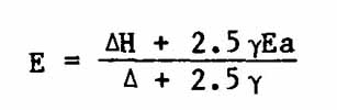
Two physical effects of tall forest canopies which influence the rates of water loss are the direct evaporation of intercepted rainwater from the large areas of wetted foliage and the aerodynamic roughness presented by the canopy to windflow over it. These required field studies of the boundary conditions above a forest canopy and involved elaborate and expensive experimentation. In 1971 the Institute of Hydrology erected two steel towers 30m high in the middle of a 70Km area of uniform pine plantations at Thetford in England. The trees were 15m high and still growing. The towers carried profile sets of sensors for windspeed, temperature and humidity, together with both total and net radio-meters. This equipment measures both the energy balance and the vertical flux of water vapor by the "Eddy Correlation" method. The latter requires rapid electronic recording, with the signals passed to a computer at the base of the tower. This advanced equipment has shown that evaporation rates from a forest are greater in wet weather and less in dry weather than that from short green grass well supplied with water, which was the reference standard in Penman's original work. Both adjustments serve to increase the importance of the ventilation term relative to the radiation term in the Penman equation. The evaporation rates under conditions of heavy cloud and frequent wetting of the foliage by rainfall could require up to twice the amount of energy supplied from a cloudy sky. This energy deficit was found to be met by the cooling of the air stream and the cooling of the forest biomass (Stewart and Thom, 1973; Thom et al., 1975). As a compromise adjustment for these effects, Thom and Oliver (1977) have shown that the evidence justified an increase in the weighting factor for the ventilation term Ea against the radiation term H so that
This equipment is now set up over the Amazon tropical forest near Manaus, where a new compact sensing instrument, known as the "Hydra" uses an ultrasonic anemometer for vertical windspeed, an infrared hygrometer and a thermocouple thermometer, with a built in microprocessor (Shuttleworth et al., 1984).
Such highly specialized equipment is emphatically not necessary for watershed management. I have described the work in order to emphasize that science has made rapid progress in the last three decades towards understanding the processes which control the hydrological cycle down to the details important for field management. Your policies as watershed managers should now be guided more by science and less by old empirical traditions.
WATERSHED PROBLEMS AFTER FOREST REMOVAL
Productive Use of Steep Watershed Slopes
Agricultural tree crops established with sound engineering of roads, terracing and drainage routes have successfully replaced hillside forests. They have demonstrated soil stability for 50 years or more in plantations of tea in Assam and in Kenya, rubber in Sri Lanka and both rubber and oil-palm in Malaysia. As natural forest sources of cellulose for industry are rapidly dwindling, the opportunity to replace them by tree plantations has attracted industrial finance.
In the Philippines, plantations for the wood-processing industries are providing employment and better living standards for rural communities. Albizzia falcatara and Eucalyptus deglupta are the main species grown. In Karnataka State in southern India, forest clearing has been followed by continuous subsistence cultivation without fertilizers, so that the initial soil fertility has been exhausted. Even in mild topography, massive losses of topsoil by sheet erosion have resulted. of Karnataka's 3.5M ha of gazetted forest land, 50% has already been reduced to wasteland (Sunder, 1982). Industrial organization of labour-intensive forms of cellulose production (bamboo for paper, eucalyptus for paper pulp and rayon, poplar for matches) has returned large areas to production, rural employment and prosperity (Banerjee, 1982).
Fruit tree crops have been introduced as an alternate livelihood for hill farmers in the steep upper watersheds of Himachal Pradesh, where 70,000 ha of apples were planted. The effects on watershed cover were adverse since 150,000m of standing timber is cut annually for packing boxes. One Kg of wood accompanies every 2Kg of apples down to the plains.
Control of Subsequent Land-Use
A limitation of paired valley studies, whether or not combined with energy budgets, is that they are all based on wellcontrolled use of land. For temperate zone forests this is, in general appropriate. In all 94 experiments reviewed by Bosch and Hewlett the cleared land was replanted or allowed to recover without further disturbance., Even in the case of forest harvesting by clear felling, skillful logging management can prevent erosion gullies, while a protective soil cover is rapidly restored by volunteer growth of grasses, forbes, shrubs and pioneer tree species or by replanted trees. It is essential to distinguish forest harvesting and regrowth under good management from forest destruction.
Where the logged forest is invaded by subsistence cultivators and graziers, the regenerating woody vegetation is harvested for firewood, while the competitive overstocking and intensive overgrazing destroys the grass cover. The high infiltration rates associated with forest are rapidly lost. Increased surface run-off causes soil erosion and the transport of rock rubble. Reduced infiltration limits the recharge of aquifers so that dry-season spring flows fail. These severely adverse effects on the hydrology of watersheds are not caused immediately by the removal of the forests but develop from subsequent misuse of the exposed land surface. It is important that well-conducted harvesting of tropical forests should not be opposed by confusion with the more general destruction by land misuse (Hamilton and King, 1983).
Such destructive changes are now occurring on a massive scale in the developing countries of the tropics, as a result of rapid increases of population which are overwhelming the natural resources available to support them. About 80% of the world's annual population increase now takes place in tropical countries dependent upon subsistence agriculture. This rising flood of humanity is invading and destroying the remaining tropical forest at a rate of 11.3 million hectares per annum. The 1982 FAO/UNEP report estimates the current rates of deforestation:
| Tropical America | 5.6M ha p.a. |
| Tropical Africa | 3.7M ha p.a. |
| Tropical Asia | 2.0M ha p.a. |
| Total | 11.3M ha p.a. |
The countries which are losing their forests most rapidly are, in Tropical
America, Paraguay, Costa Rica, Haiti and El Salvador; in Tropical Africa,
Ivory Coast and Nigeria; in Tropical Asia, Nepal, Thailand and Sri Lanka
(OTA, 1984). Where the land under forest is suitable for sustained production
of food crops there is no doubt that clearing will continue. The proper
concern for governments is then the maintenance of enlightened landuse
policies for conserving forest on areas critical for hydrological stability,
for protecting areas important for the conservation of genetic diversity
of plant species, for ensuring that the forest is harvested rather than
burned and that the land is organized for contour cultivation by the well-known
technologies of soil conservation.
Regrettably that is not the picture observed by the author in recent visits to streamsource watersheds of many tropical countries on three continents. The normal picture is of crude harvesting methods used by commercial contractors with only nominal supervision by Forest Departments. There is usually no effective control of field work to minimize damage to soil and water resources. Even more serious is the lack of official (and ultimately of political) interest in the fate of the logged areas. The roads, tracks and temporary bridges built by the contractors serve to open up forest lands to uncontrolled invasion of firewood contractors, forest squatters, illicit cultivators and uncontrolled livestock.
PROTECTION OF NATIONAL DEVELOPMENTS DOWNSTREAM
Flood Control by Forests
The flood-plains of the Indo-Gangetic river systems were developed by inundation's from forestcovered mountains before watershed damage by man had become a significant factor. It is necessary to remember that however excellent a cover the closed tropical forest provides, it can become completely saturated by heavy tropical rainfall. Most of the main Himalayan slopes receive from 2m to 5m of rainfall in six months, with large areas of mountains draining to a confined outlet. This concentrates large volumes of water into a single channel. Nepal's eastern 20OKm of the Himalayan Range, for instance, concentrates flow into the Sap Khosi. Not even a complete cover of dense forest can then prevent flooding in the lowlands. A measured example is from the headwaters of the Mekong River which forms the boundary of northern Thailand. At Chiang Saen, near the border with Burma, the Mekong has been gauged for 20 years from a watershed of 200,000Km , almost all of it under tropical forest. The average flow is 2800m /sec. The annual pattern is of six months of low flow, rising with the monsoon to a sharp peak in September. The forest becomes saturated so that the average annual peak flow is 46 times the annual average low flow (National Energy Administration, 1977). Although the saturated forest cannot hold up the water it does hold the soil in place. The retention of such soil protection on steep slopes under tropical rainfall is of critical importance to the majority of the watershed inhabitants who live in the lowlands. India and Pakistan both offer large-scale examples of the damage done by transported soil and rock rubble from misused upper watersheds to both storage reservoirs and irrigation developments below.
All six of India's 5-year Plans have included central funds for soil conservation in watersheds and flood control embankments on the plains. Thirty-one major river-valley projects of watershed improvement were sited to protect major reservoirs on flood-prone rivers. The Ministry of Agriculture's Soil and Water Conservation Division reported in 1980 on 21 of these reservoirs in which sediment sampling records provided evidence of rates of silting. The total of eroded land area needing treatment in the catchments of these 21 reservoirs was surveyed at 45.8 million hectares. Only one of the reservoir catchment areas has as yet been thoroughly treated. This is the Mach Kund Reservoir whose 200,000 ha catchment is now delivering less sediment than the "design rate" measured when the dam was built. All the rest are silting up at from two to twenty times the rates measured when they were constructed (Ministry of Agriculture, 1980). India has become fully aware of the dangers already developing from the deterioration of the Himalayan watersheds and the progressive increase in the areas of the plains damaged by floods (Pereira, 1984).
In Pakistan over 70 million people depend on the 14 million hectares of irrigated land in the Indus Basin, but the whole system depends on "run of river" irrigation, with only few days' supply in storage reservoirs. The monsoon seasons produce flood-flows followed by shortages. The only two substantial controlling reservoirs are those of the Mangla Dam (1967) and the Tarbella Dam (1976), both constructed with funding support from the World Bank in order to provide both irrigation and hydro-power generation. Both are being rapidly destroyed by sedimentation from very steep forested watersheds which are being invaded and damaged without effective control. Bank-cutting by torrential flows from a system of geologically young mountains will inevitably cause some sedimentation, but this was measured at the design stage and has been greatly increased -- some reports say to double the initial rates. There are active reforestation programmes in progress, but no effective prevention of continuing damage to the watersheds. Plans are already in hand to replace the lost capacity but Tarbella will have lost one-third of its capacity before the next dam at Kalabagh can be completed (WAPDA, 1979).
In summary, forests cannot prevent floods but they can and do prevent accelerated soil erosion and destructive sediment transport by floodwaters. They give valuable protection to water resource investments in irrigation, hydropower and urban water supply.
Hydrologically floods can only be prevented by construction of major storages (such as the Hanumannagar Barrage on the Sap Khosi already mentioned as flood-prone). Where storages still await development it is very important to arrange land-use on the flood plains so that large diversion areas, preferably surrounded by embankments, remain free as temporary storages. They provide valuable grazing in the dry season. Much work is still needed in the Gangetic plains to avoid permanent habitation of natural flood-storage area.
Crisis in Tropical Fuelwood Supply
Of the total amount of wood removed annually from tropical forests, which is of the order of 1Bn m , some 80% is used for firewood. The World Bank (1980) estimated that the annual rate of planting required to meet this demand is 21 million hectares. An FAO map of the fuelwood situation in developing countries in 1981 indicated that the present rate of planting needs to be increased by five times to meet demand.
In India, for instance, the need for fuelwood is estimated at 133 million tonnes a year, while present production is only 49 million tonnes. As a result of firewood shortage, cattle dung from the farming areas, which is urgently needed for crop production, is dried and trucked to the cities for fuel. There is, thus, a very serious drain on soil fertility in a country which is struggling to increase food production to keep pace with population growth.
In Nepal, where more than half of the population of 14 million live by subsistence agriculture on mountain slopes (much of which would be too steep for arable cultivation in any rational system of land-use) the remaining forest is rapidly vanishing at 4.3% p.a. A recent study of the land-use aspects of fuel production by the World Bank (1983) surveys the decreasing forest area and the degradation of quality of the remainder. A massive increase in wood-fuel plantation rates is advocated, amounting to more than three times the maximum annual rate which the country has as yet achieved. The resulting changes in land-use and opportunities for employment in the hills would contribute substantially to the solution of the acute problems of agricultural degradation in the "Middle Mountains." The problem is so urgent that more than 40% of the forestry projects funded by the World Bank are now for fuelwood.
Social Forestry Projects
Not all of the fuelwood planting is on forest departmental lands. There has been a strong movement towards persuading village communities of subsistence farmers to regard firewood as a crop. The help and guidance of trained foresters in setting up nurseries and in supplying seed of fast-growing tropical species is still necessary, but the costs of establishment and maintenance are greatly reduced. The costs of timber plantations are often increased by the endless contests of forest guards against fire, livestock damage and theft, as a result of community indifference to an outcome in which they have no share. When the community owns the plantations these costs are minimized. In India, for instance, the government has responded to the fuelwood shortage by budget allocations for an ambitious national programme of plantations. The current Sixth Plan (1980-85) includes over US$700M for forestry of which $200M is for the Himalayan states.
Half of the proposed 4M ha of new plantations lie outside the forest estate. These include both industrial plantations for cellulose and "social forestry" schemes for distributing planting material to farming communities. Such planting of windbreaks, hedgerows, terrace banks, road and canal edges has been outstandingly successful in two early schemes supported by World Bank funding in Gujerat and Uttar Pradesh. Although it is now fashionable to call this "agroforestry" it has been a tradition for a long time in the drier parts of the tropics, far from any free source of forest produce. In Rajasthan selection by farmers has evolved a tall, compact variety of the hardy Prosopis cineraria which is planted in the fields among the food crops with minimum shading effects. Where irrigation is available to compensate for moisture competition by the tree roots, as on the Gangetic plains, such plantings are increasing rapidly. In the lowlands where technical help to village communities can be provided over a good road network, this secures effective economy in the use of trained forest staff.
Trees as Sources of Fodder
The most hydrologically critical areas of steep watersheds are at the boundaries of the cultivated areas where land becomes too steep or rock-encumbered for cultivation. Traditional rights to gather firewood have been intensified by population growth so that complete stripping of the woody vegetation results. Even so, under a rainfall capable of sustaining a forest, growth of ground cover is rapid at tropical temperatures. Grasses, herbs, shrubs and regenerating sprouts give some soil protection, but the competitive exploitation of such communal grazing has resulted in overstocking to the point of destruction. In the Indian sectors of the Himalayan Range the total population has increased by one-third in 10 years, from 32M in 1971 to 43M in 1981 on steep mountain slopes where only some 10% of the area is cultivatable. In the eight hill districts of Uttar Pradesh about 70% of the family holdings are less than one hectare (FAO, 1982). in the upper watershed areas of the Yamuna, from which increasing floods have damaged New Delhi, the pressure of population is destructive. From the State Forests of Himachel Prades each family of five has the traditional right to collect 4 tonnes of firewood and 22m of standing timber for housebuilding. In addition, grazing in the forests is overstocked to three times the maximum sustainable carrying capacity (Gupta, 1980). In Nepal the overstocking is even more extreme, with some 6M cattle and 3M sheep and goats kept on mountain slopes between 1500m and 2500m altitude, grazing mainly in gazetted forest land. The animal husbandry staff of HMG estimates present populations as some nine times the long-term carrying capacity of the slopes; animals are half-starved and production is minimal. Meat for Kathmandu is imported (Rajbhandary and Shah, 1981).
In the dry season, which is characteristic of monsoon climate, the only available fodder is the foliage of trees, which is collected and carried long distances, often from steeper and less accessible forest land. A wide variety of species are lopped right up the crown. Since they have no opportunity to set seed, regeneration of the most prized species is effectively prevented. Some fodder trees are scattered along with edges and banks of terraces but there is no tradition of deliberate planting of fodder trees. Panday (1982) lists 135 species used as fodder in Nepal.
Tree Species for Fuel, Fodder and Building Poles
For more than a century the forestry profession has studied tree species for timber; for about half a century high volume pulpwood production has had scientific attention. The many tree species useful in the tropics for rapid production of fuelwood, fodder and building poles now offer a wide and profitable field for applied research and development. The Australian species have been studied the most. Eucalyptus and acacias have been widely used in developing tropical countries over the past fifty years, but more recently the field study and selection of improved strains has begun on an ever-increasing range of species. Work on the Mexican species Leucaena leucocephala has made progress in Hawaii, in the Philippines and in tropical Australia for use in low altitude tropical climates. As a legume for soil fertility improvement, a forage crop, a rapid producer of firewood and light building timber and a source of edible seed-pods, this species has already attained a recognized place in tropical development programmes. The National Academy of Sciences of the USA held a series of international studies on this and other useful species and has produced three invaluable handbooks, Leucaena (N.A.S., 1977); Tropical Legumes (N.A.S., 1979); Firewood Crops (N.A.S., 1980). Outstanding species are:
(i) for the warm wet tropics, Calliandra calothyrus, which will compete
with and suppress the formidable grass-weed Imperata cylindrica
(ii) for warm lowland topics with severe dry seasons Leucaena leucocephala.
This has a wide range of varieties with growth habits varying from a shrub
to a 20m tree. The provenance can be critical to success.
(iii) for a wider altitude range, up to 2000m in the tropics, the range
of Eucalyptus spp. and Acacia spp. is so wide that preliminary trials
of species for suitability to a climate or soil type are strongly advisable.
In the eucalyptus, so much intensive selection has been done that the
provenance can be more important than the species. It is necessary to
seek expert advice before investing in a plantation.
(iv) for cool moist tropical highlands from 1500 to 3000m the Himalayan
nitrogen fixing Alnus nepalensis is an important tree, particularly for
restoration of steep disturbed sites. Seed can be broadcast in situ.
(v) for slopes at or near the tree-line on high mountains the live-oak
Quercus incana is valued by nomadic herdsmen as a source of fodder. The
network of surface roots stabilizes steep slopes; they sprout readily
to form thickets.
(vi) for the lower extreme of the watershed Casuarina equisetifolia will
grow in sand deserts on saline groundwater. It has been used to great
effect in Egypt for desert reclamation, and in many tropical countries
for coastal planting, windbreaks, firewood and timber.
REHABILITATION OF WASTELANDS
Where Economics Complement Ecology
The problems thus outlined affect to a greater or lesser extent 76 countries located mainly or entirely within the tropics. These countries all have rapid growth rates of population, low per capita incomes and strong dependence on subsistence agriculture. They contain about two billion people, or half of the world's present population. Within the short span of 30 years they will contain 4 billion people (OTA, 1984). By that time, without drastic improvement to land-use and agricultural productivity, many of these countries will be unable to feed their populations.
Watershed management has a critically important role in combating this Malthusian threat. Fortunately, both the ecological and economic rehabilitation of misused watershed slopes are complementary and the main technologies for recovery are well established.
An immediate improvement in food-crop output can be secured by retaining the organic matter and nutrients of crop residues and cattle manure on the farms. At present, stalks and straw are burned as domestic fuel which the cattle dung is dried and sold to urban areas for fuel. Fuelwood and fodder planting, as already described, can halt this insidious attrition of soil fertility. Where grown on steep slopes unsuitable for arable crops, the fuel and fodder plantations will stabilize soils and improve the reception of rainfall.
Cultivation on the contour, with well-built terraces, cut-off drains and organized surface drainage along safe routes are well-developed technologies for preventing major soil losses. Such land-shaping will, however, be eventually defeated unless soil surfaces of tilled fields are protected by good crops. High densities of crop stands and vigorous root fibre development are necessary to the stability of hillside farming (Pereira, 1975).
Thus as the steeper slopes become more productive of woodfuel and fodder and the hillside farms produce better crops, less soil and rock rubble will damage the reservoirs on which the more intensively developed lowlands depend for irrigation and power supply.
Replanting of Destroyed Forest Lands
Wastelands are the residual condition of former forested, agricultural or grasslands, which have been misused to the stage at which they are almost totally unproductive. Their restoration depends on the extent to which the soil mantle has been physically removed by erosion. Even in the most severe cases some pockets of soil usually remain among the rocks. This soil will be rapidly covered by hardy pioneer grasses, herbs and shrubs if protected from grazing. it may support a cover of hardy trees or shrubs if these are planted. Such communal wastelands, however desolate, are usually patrolled by halfstarved livestock which prevent any such development of stabilizing vegetation. Attempts to protect such lands by policing with forest guards or by fencing is both costly and rarely successful. Where a useful depth of soil remains, so that more vegetation volunteers, the overgrazing is usually even more intense.
While unprotective forest remained to be consumed, the villagers and indeed the urban-based governments have shown only nominal concern. Increasing fuelwood and fodder scarcities have recently begun to alter this attitude of indifference, so that political interest is being aroused in the possibilities of profitable remedies. Technologies do exist, based on direct field research, which have been demonstrated as both effective in practice and acceptable to subsistence village communities. They depend, however, on a minimum input of leadership and modest funding to generate the initial momentum for change.
Although the cost per hectare is modest, the scale of the problem is formidable. A recent survey (FAO/UNEP, 1982) gave a world estimate of the rate at which wastelands are developing as forest is removed. Every year a total of 11.3M hectares of the remaining tropical forest are cleared and converted to other uses. Of the 5.58M ha of closed tropical forest which are felled annually, 4.18M ha are logged in a manner which permits some recovery while 1.40M ha are left unproductive. Migration increases the totals living by "slash and burn."
In India, in addition to 13M ha of wastelands in need of treatment, one-third of the 20M ha of gazetted forest land has been so severely damaged that active soil conservation measures are required. The agricultural sections of India's watersheds are even more seriously affected, with 58% subject to severe erosion (Randhawa, 1982).
Although technical solutions to such land misuse are well established, the problems of social organization are in practice much more difficult. The technical solutions require changes in the outlook and practices of subsistence communities. Their population growth and primitive methods of land-use has reduced them to a level of poverty which threatens survival. They have no margins to permit experiment and need to see successful demonstrations that the changes will bring them profit in their own environment. The solutions are best illustrated by case studies from the field.
Nepal provides an instructive example. As already described, crop yields and food production per capita are declining in the hills which are seriously overpopulated and overstocked. In spite of substantial migration to the Terai, hill populations have increased by more than one-third in the last two decades (Nat. Bur. Stats., 1982). The interdependence of farm and forest, which was viable for small populations of people and livestock, has been unbalanced by population growth. On terraces, exhausted by continuous cropping, farmers no longer attempt to plant cereals unless cattle dung is available. With inputs carried by porters for one to three days over rough steep trails, use of fertilizers is negligible. Crops, thus, rely on the nutrients gathered from the forest lands by the livestock. But with free-range grazing about 60% of the dung is lost and only the 40% dropped in the pens at night is available for the terraces. Competitive overstocking together with collection of all woody growth for firewood has had the effect of turning these productive, well watered slopes into barren lands. The nutrients cannot be transferred unless the plant population is allowed to grow and to extract them from the soil. These hillside communities are rapidly reaching a terminal situation.
A successful solution was demonstrated by a new Department of Soil Conservation and Watershed Development which was set up in the Ministry of Forests with the help and reinforcement of the UNDP/FAO Integrated Watershed Management Project. Seven years of joint work has demonstrated a solution which has convinced the hill-farming communities involved. The basic move was to persuade hill communities in the heavily populated Phewa Tal watershed to stall-feed all of their stock (Fleming, 1983). In return they were offered employment to replant the formerly forested wastelands with both fuel and fodder trees. Standard gulley control structures of rock-filled wire-mesh gabions were built and the gulleys were planted with vigorous fodder grasses such as Pennisetum purpureum, Cenchrus ciliaris, Setaria sphacelata and the fodder legume Stylosanthes guianensis. The steep denuded slopes were planted with the hardy, nitrogen-fixing Alnus nepalensis. Fodder trees (Artocarpus lakoochia) were raised in large numbers in the nurseries and issued to the farmers.
An important aspect of the change was that the women found the tasks of cutting and carrying fodder grass from the planted gulleys and of carrying manure from the cattle pens to the terraces was less than the effort required to search the mountainside for dried cattle dung and collect it for the crops. They, therefore, welcomed and supported the changes. As soon as the cattle were penned, grasses regrew on the slopes. Grass cut from between the trees was surplus to requirements and was sold to neighbors. A major benefit was that the increased supplies of manure from the stall-fed cattle made possible a winter crop of wheat after a summer crop of hill rice. The terraces were previously left fallow in the winter for lack of manure. With stall-feeding the productive buffalo cows could be used, giving 4 ½ litres of milk per day as against half a litre from the small bovines. The buffalo bull calves were raised and sold for meat, which was not permissible for the bovines in a predominantly Hindu country. After three years an assessment by an economist was that the income of the groups within the scheme had risen by about 400%.
In spite of the advantages, however, the change proved to be too drastic, on initial presentation, for the majority of the panchyat. Only 3 out of 10 wards agreed to take part. Within two years all of the remaining seven wards had applied to join. An essential feature of the restoration programme is that a small input of funds, for 2 years, to enable villagers to replant the wastelands, has channelled most of the funds directly into the hands of the poorest section of the community. Those experienced in such aid schemes will recognize that such a target is all to often missed.
A benefit to cost ratio over a 20-year programme discounted at 10% has been calculated, with all livestock stall-fed by the seventh year at I to 1.7 (Fleming, 1983). This omits approximately US$0.5M for piped gravity-flow water distribution from a major spring source high in the watershed. There is little chance of successful establishment of stall-feeding without assistance with water supplies. On the basis of the inevitably uncertain assumptions of population growth rates from the present state of 21,000 people on 11,000 ha of mainly steep land, benefits would exceed costs even after including water supply.
Ten rural development projects, funded by a variety of donors, are now in progress in about half of Nepal's hill districts. These separate projects have no organized cooperation, other than a "community forestry" programme of World Bank/FAO technical aid to establish nurseries and to encourage villagers to undertake planting of fuel and fodder. This is proving to be slow but successful.
Restoration of Overgrazed Savanna
At the drier end of the scale, open savanna woodlands have been reduced to wasteland on a major scale in Africa by a similar competitive overgrazing of livestock on communal lands. In both the humid forests and the dry savanna the rich botanical flora which are characteristic of the tropics give some resilience, so that recovery of land severely damaged by overgrazing is more rapid than in temperate climates. A detailed example from severely ill-used savanna woodland in the headwaters of the Nile in Uganda provides some hydrological detail. This study was unusual in that measurements were taken on two adjacent catchments, each of 400 ha, without disturbing the pattern of severe overgrazing followed by the Karamajong tribesmen (Pereira et al., 1962). Sample quadrants throughout both catchments showed 40% of bare soil for 9 months in the year. The savanna woodland had degenerated into Acacia thornscrub which formed dense thickets interspersed with bare eroded soil. Spate flows from this area under a rainfall of 750mm were damaging roads and bridges. Concrete flumes of 39m³ /sec capacity were built on each 400 ha watershed. Depth of penetration of rainfall into the ground was recorded by 20 profile sets of gypsum block tensiometers.
After a calibration period of 4 years one basin was chain-cleared of bush, closed to grazing and allowed to recover. In two years of complete protection, recovery was unexpectedly rapid. Kerfoot (1962) identified 59 species of grasses of which 37 were perennials. Penetration of rainfall remained at 0.5m depth on the overgrazed control catchment but averaged 1.25m depth on the rested land. Peak flow hydrographs remained the same shape but were halved in volume as more water percolated into the soil (Edwards and Blackie, 1981). After two years recovery was good enough to begin controlled grazing. Cattle were fattened at one beast per 4 ha, while on the control catchment all stock remained halfstarved under the tribal pattern of stocking at one beast per 21 ha during the rains and one beast per 30 ha for the dry season.
WATERSHED PROBLEMS OF DRYLANDS
Dry Tropical Forests
Humid evergreen tropical forests provide excellent soil protection and are almost completely immune to fire. They persist unchanged, as Shantz and Turner (1958) showed by a half-century comparison of photographic surveys. The stability and protection of soil diminish with rainfall. In drier tropical climates forests may be deciduou's, as in the case of Thailand's Dipterocarp tree cover. These are burned deliberately and frequently by a population which is singularly enthusiastic about fire-raising. Palls of smoke which hang over the hills in the dry season are so dense that fire-watch towers are rendered useless. The trees are fire-resistant so that only forest litter and undergrowth are burned leaving the soil bare. Sheet erosion is, therefore, general, flood control is diminished and sedimentation increased. These watersheds need careful management to prevent soil erosion, the public needs education about fire hazards. Over the tropical African plateau, with annual rainfall of 1000mm or less and with six months or more of d season, the woodland savannas are important for stabilization of watershed slopes but are,! extremely vulnerable to fire. Under severe grazing pressure, as in the Sahel, they deteriorate rapidly into wastelands.
Management Problems in Semi-arid Lands
A characteristic problem of tropical drylands is the extreme difficulty of protecting stream source areas. Many isolated hill features or small ranges promote rainfall enough to sustain local forests and to supply streamflow to dry plains. The streams are critically important for graziers and their livestock but the trees are vulnerable to attack by herdsmen seeking fuelwood and fodder.
Such isolated forests are difficult to guard. East Africa has many examples where the cutting of the forests and the trampling by livestock over the stream source areas, although increasing the net output of water, so reduces infiltration rate that aquifers are not recharged, spate flows are increased during the rains and streamflow fails in the dry season.
A recent report from the UN Environmental Programme (UNEP, 1984) provides very sombre reading about the continued increase in the "desertification" of the world's drylands. The problems are most acute in the tropical and subtropical drylands where the UN Desertification Conference in 1977 estimated that some 57 million people were in serious trouble as a result of the destruction of rangelands by overgrazing. The 1984 assessment is that these numbers have now reached 135 million. The total population at risk from dryland deterioration is now estimated at 850 million.
The most acute areas of destruction, resulting both from population increase and the misuse of resources, are reported from the rainfed tropical croplands of Africa south of the Sahara, Andean South America and Mexico and parts of southern Asia, including the Himalayan lower slopes. Land degraded to desert-like conditions, some of it irretrievably lost, continues to increase at 6M ha p.a. Land is being reduced to zero productivity at an increasing rate which has now reached 21M ha p.a. Much of this latter category could be restored to productivity by rational management.
Action by the governments responsible for these drylands has been inadequate in the programme from 1977 to 1984 and "field -oriented actions to arrest desertification processes are in a minority, with a tendency for the funds directed to desertification control to dwindle as they move downwards through the administrative machinery." The advice of the UNEP review was that governments should concentrate on restoring grazing control and soil conservation to the better-watered and more productive areas first, since the destruction of these areas inflicts the greater loss. Afforestation methods have received the most support. Foresters have an important role in dry savanna watersheds, where their guidance can develop village woodlots, windbreaks, dune stabilization and tree cash crops such as the Acacia senegal for gum arabic in addition to fuel and fodder.
Use of Trees in Dryland Watersheds
Although fuelwood and fodder are even more scarce, water supply is of more critical concern. The water use of trees is, therefore, a sharply debated issue of watershed management in drylands. The main facts are now well established. Protection of spring-source areas to maintain rainfall infiltration to ground-water is a basic requirement. While this can often be assisted by tree-planting and protection on steep slopes, do not plant trees across marshy spring source areas. Tree plantations have a lower reflection coefficient than the grass cover and therefore absorb more radiation to be used in evaporation. Their foliage is exposed to more ventilation as compared to grass, and the foliage itself increases aerodynamic roughness which further increases evaporation. A practical method used in the past to combat malaria in East Africa was to plant Eucalyptus robusta directly into marshlands in order to lower the water table and dry the surface.
Where the banks are steep and high flood-flows are experienced, tree roots have an important stabilizing effect. High flood-flows in semi-arid country may sound like a contradiction in terms, but they do, in fact, occur. The most obvious source is from higher ground. The Himalayas, as already discussed, have very heavy and widespread Monsoon rainfall which has developed the Indo-Gangetic plains by repeated inundations. With increasing population pressure and misuse of steep lands, the soil and rock debris carried by the floods causes increasing damage in the lowlands. The atmospheric movements which concentrate precipitation into flood dimensions are usually on a scale many orders of magnitude greater than that of the land area affected. When there is a major coincidence of atmospheric events, such as a combination of convergence systems of the lower and mid troposphere, major floods can occur in usually dry areas.
An example occurred five years ago in Rajasthan, where the long-term annual rainfall ranges from 300mm to 500mm. A major storm which was a normal part of the monsoon season coincided with a convergence centre moving in the mid-troposphere westerlies from Pakistan. A total of twice the annual rainfall was delivered in five days over an area of 14,000 Km² of the upper watershed of the Luni river. Floods overwhelmed the countryside, which is of low relief, leaving 470 people dead or missing and damage of the order of $100M (Sharma and Vangani, 1982). In the upper catchment of the Luni River the streams became 2Km to 3Km wide, flowing 5m above normal levels. Tree planting was demonstrated to be of major importance for resistance to flood damage, especially as reinforcements to earthen banks of rivers and roads. Bulbul (Acacia nilotica), Neem (Azadirachta indica) and Prosopis species showed good resistance but riverside growth of Tamarix were washed away completely. Two types of fruit tree, Ficus spp. and Zizyphus mauritiana were strongly resistant to flood flow and saved many lives.
Examples of violent torrent flows in the wadis of the Negev Desert have been described in detail by Hillel (1982).
LONG-TERM MANAGEMENT STRATEGY
Protection of Downstream Investments
In mountain or hill watersheds, relatively small numbers of people living in the headwater areas can cause major damage to national investments in irrigation and power supply in the lower reaches of river systems. They, thus, injure the much larger downstream communities. Land-use in the upper watersheds should, therefore, be controlled in the national interest. This requires national investment in roads, services and amenities to secure closer administration of remote areas and the control of immigration and settlement on hydrologically critical slopes. 4 Land misuse in remote upper watersheds throughout the tropics is due mainly to political and administrative neglect by the major urban communities downstream.
Population Growth
The basic cause of watershed problems of land misuse in the tropical world of developing countries is pressure of population. The excessively rapid growth rate of human populations increases dependence on subsistence cropping and on livestock keeping by methods no longer viable with present numbers. Science offers no prospects of devising land-use policies to sustain the continuation of present growth rates.
Livestock Control
Watersheds in both humid forest and drylands are being damaged extensively by freeranging livestock in excessive numbers limited mainly by starvation. In steep forested high rainfall country, free-range grazing is [often) unacceptable in the public interest. Viable alternative technologies of stall-feeding are known and should be adopted. In drylands, viable technologies are known but need higher management skills. Management of stock numbers and increases in quality are needed. Upgrading of livestock fails unless husbandry practices are improved. Control of livestock should be recognized as urgently necessary in the national interest.
Fuel Production a Priority for Upper Slopes
The acute shortage of woodfuel, which is approaching crisis levels in many tropical countries, can be met with maximum ecological advantage by large-scale plantations in steep high-rainfall watershed areas. This can offer productive employment to alleviate the increasing poverty of hill-farming communities on misused land.
4 Later papers discuss incentives and other mechanisms for
achieving upland management goals (ed.).
5 Large-scale plantations may be unrealistic in many densely
populated upland water sheds (ed.).
Revision of the Training Syllabus in Forestry
The main target of all forestry training in the tropics and the main interest of most professional forestry staff remains the production of sawtimber. There must now be recognition that responsibility for the Forest Estate now includes production of fuel and fodder and the restoration of wasteland to productivity. Those tropical countries which have training facilities in forestry now need to adopt as a national strategy the revision of the syllabus to widen the range of knowledge and objectives.
LONG-TERM MANAGEMENT POLICIES
Community Organization for Restoration of Wastelands
Misused land in upper watersheds should be corrected by agreement with the farming communities. The essentials are the cessation of free-range grazing, the stall-feeding of livestock and the employment of the cooperating farmers, under Forest Department guidance, in the replanting of wasteland with both fuel and fodder trees. Only when profits are seen to accrue to the local community will such changes become permanent. Stepwise transfer to local communities of responsibilities for previously misused slopes in the Forest Estate is a policy for which there is good evidence of success. Reserve powers by professional forest supervisors to ensure against technical mistakes or local failure of leadership are regarded as necessary by some countries, where the State responsibilities for watershed protection are recognized.
Fuelwood and Fodder Enterprises Outside the Forest Estate
By tropical traditions fuelwood and fodder have been gathered free while food and cash crops have been planted. The economic value of fuelwood is now so high that fastgrowing tropical tree species can offer good returns as cash crops. Forestry Departments, policies should include the establishment of both State and private nurseries to supply seedlings and foddergrass planting material. Growing of leguminous fodder crops is already an established enterprise near tropical cities where cows are stall-fed for milk. Very large areas of terrace banks and other steep land are available higher in the watersheds. Agricultural Department policies should actively promote their planting with legumes and fodder grasses.
In-Service Training of Forestry Staff
While the revision of the forestry syllabus is a long-term strategy for future staff, the need to remedy the gaps in the training of staff now in post should be recognized as a high priority for the improvement of watershed management. The in-service training must begin with the professional staff but the larger task of retraining forest guards who are in direct daily touch with hill communities in the production of fuelwood and fodder should be an important part of departmental policy.
Restriction of Commercial Logging to Nondestructive Methods
Productive forestry, when well enough conducted to achieve sustained output, is an important national asset in many tropical countries. However, as already noted, every year 11.3 million ha of forests are logged, some of them in a manner which effectively terminates future production. This is a national loss, which can be prevented only by political acceptance at the highest levels of government that national assets will no longer be destroyed for private gain.
Where watershed forests have been protected, there are often too many over-mature trees, so that management would be improved by nondestructive harvesting. Forest Departments should, therefore, encourage local labour intensive enterprises for the use o hand-carried equipment, pit sawing and carriage to market by porters with minimum damage to soil, water or tree resources, Such a policy will certainly require an increase in Forest Department supervision but this is the price that the major communities in the lowlands should be prepared to pay to secure soil and water resource protection above them.
Forestry Staff Cooperation with Soil Conservation Specialists
The millions of hectares of wastelands in the Forest Estates of tropical countries are the inescapable responsibilities of Forest Departments. The technologies to restore them are usually found in the Departments of Agriculture. Soil conservation engineers are needed to realign the drainage and to arrest soil movement in ravine lands and on slopes gullied by overgrazing.
In India, part of the central funding for major rehabilitation of flood-prone watersheds has been issued through State Forest Departments, which have recruited soil conservation staff. In Rajasthan, for instance, where the Sabi River contributed embarrassing quantities of siltladen flow to the Yamuna flooding of New Delhi, the State Forest Department set up a new "Forestry Circle," headed by an "Additional Chief Conservator." Recruiting both civil engineers and agricultural engineers as well as agronomists, they are pursuing an ambitious programme over the 450,000 ha of the Sabi watershed, most of which is under agricultural use. There are professional career difficulties for multi-disciplinary teams in highly specialized government departments and joint departmental cooperation is usually preferable, although rarely easy.
Short-term Urgency
To those able to assess the productive potential of tropical lands, much of the rural poverty observed in developing countries is seen to be unnecessary. The technical guidance to make more productive use of the land has long been available and most developing countries now have at least a few people trained in the necessary technologies. Technical assistance is internationally available. The task is to persuade political leaders that large scale improvement in watershed management is not only possible but urgent. Recovery becomes more costly and more difficult year by year as land misuse continues to damage vital watersheds. Both their soils and the drainage patterns of the valleys were developed over geological time-spans. Some are now degrading, with irreplaceable soil losses, in less than a decade. Strategy must be long term and policy must be sustained, but the decisions to initiate action on these problems need to be taken now.
REFERENCES
Barry, R. G. and R. J. Chorley. 1982. Atmosphere, weather and climate. Methuen, N.Y.
Banerjee, A. K. 1982. Report to USAID Forestry Conference, Bangalore from Titaghur Paper Mills, Calcutta. (Stencilled)
Benton, G. S., R. T. Blackburn, and V. 0. Snead. 1950. The role of the atmosphere in the hydrological cycle. Trans. Amer. Geophys. Union 31: 61-73.
Bosch, J. M. and J. D. Hewlett. 1982. A review of catchment experiments to determine the effect of vegetation changes on water yield and evapotranspiration. J. Hydrol. 55: 3-23.
Budyko, M. 1. 1958. The Heat Balance of the Earth's Surface. Translated from the Russian by Nina Stepanova, U.S. Bureau of Commerce, Washington, D.C.
Edwards, K. A. and J. R. Blackie. 1981. Results of the East African catchment experiments (1958-1974). In: Tropical Agricultural Hydrology, R. Lal and E. W. Russell (eds.). John Wiley and Sons, Chichester.
FAO/UNEP. 1982. Tropical Forest Resources. Forestry Paper No. 30. FAO, Rome.
Fleming, W. M. 1983. Phewa Tal catchment management program: benefits and costs of forestry and soil conservation in Nepal. In: Forest and Watershed Development and Conservation in Asia and the Pacific. Edited by Lawrence S. Hamilton. Westview Press, Boulder, Colorado.
Glover, J., P. Robinson and J. P. Henderson. 1954. Provisional maps of the reliability of annual rainfall in East Africa. Quart. J. Roy. Met. Soc. 80: 602-609.
Gupta, M. P. 1980. Proc. Nat. Seminar on Operation Water Management. Min. of Agric. New Delhi. pp. 40-45.
Hamilton, L. So and P. No King. 1983. Tropical forested watersheds: Hydrologic and soils response to major uses or conversions. Westview Press, Boulder, Colorado.
Hibbert, A. R. 1967. Forest treatment effects on water yield. Into Symp. For. Hydrol. Pergammon Press, Oxford.
Hillel, Do 1982. Negev: Land Water and Life in a Desert Environment. Praeger, New York.
Kerfoot, 0. 1962. The vegetation of the Atumatak catchments. E. Afro Agric. and For. J. 27 (Special issue).
McCulloch, J. So Go 1962. in: Assessment of the main components of the hydrological cycle. E. Afro Agric. and For. J. 27 (Special Issue).
McCulloch, J. So Go 1965. Tables for the rapid computation of the Penman estimate of evaporation. E. Afr. Agric. and For. J. 30: 286-295.
Ministry of Agriculture. 1980. Statistics on soil conservation in India. Soil and Water Conservation Division. New Delhi.
National Academy of Science (NAS). 1977. Leucaena: Promising forage and tree crop for the tropics. Washington, D.C.
National Academy of Science (NAS). 1979. Tropical Legumes: resources for the future.
National Academy of Science (NAS). 1980. Firewood Crops: shrub and tree species for energy production.
National Bureau of Statistics. 1982. Kathmandu.
National Energy Administration. 1977. NEA River Gauging Report Vol. 1. Bangkok, Thailand.
Office of Technical Assessment (O.T.A.). 1984. Technologies to sustain tropical forest resources. Congress of the U.S. Washington, D.C.
Panday, K. K. 1982. Fodder Trees and Tree Fodder in Nepal. Swiss Dev. Corporation. Berne.
Pereira, H. C. 1959. Practical field instruments for estimation of radiation and of evaporation, Quarto J. Roy. Met. Soc. 85: 253-261.
Pereira, H. C. 1973. Land Use and Water Resources. Cambridge Univ. Press.
Pereira, H. C. 1975. Status and potential use of land and water resources in the tropics to meet future food needs. Proc. Soil and Water Management Workshop. USAID. Washington, D.C.
Pereira, H. C. 1984. Land-use policy and practice in Himalayan watersheds. Proc. 4th Agricultural Sector Symposium: World Bank. Washington, D.C. (in press).
Pereira, H. C. and P. H. Hosegood. 1962. Comparative water use of softwood plantations and bamboo forest. J. Soil Science 13: 299-314.
Pereira, H. C. and J. S. G. McCulloch. 1960. The energy balance of tropical land surfaces. Tropical Meteorology in Africa. pp. 318-326. (Proc. WMO-Manitalp Conf.) Met. Dept., Nairobi.
Pereira, H. C., J. S. G. McCulloch, M. Dagg, P. H. Hosegood, and M. A. C. Pratt. 1962. Hydrological effects of changes in land-use in some East African catchment areas. E. Afr. Agric. and For. J. 27 (special issue).
Rajbhandary, H. B. and S. G. Shah. 1981. Trends and projections of livestock production in the hills. HMG Min. of Food and Agric. Kathmandu: Nepal's Experience in Hill Agricultural Development. pp. 43-58.
Randhawa, N. S. 1982. Watershed management in India, an overview. Proc. Nat. Symp. on Soil Conservation and Water Management in 1980's. Ind. Assoc. Soil and Water Cons. Dehradun.
Roche, M. A. 1981. Watershed investigations for development of forest resources of the Amazon Region in French Guyana. In: Tropical Agricultural Hydrology. (Lal and Russell, eds.) John Wiley and Sons, Chichester, U.K.
Salati, E., A. Dall'Olio, E. Matsui and J. R. Gat. 1980. Recycling of water in the Amazon basin: an isotopic study. Water Resources Research 15: 1250-1259.
Sengele, N. 1981. Estimating potential transpiration from a watershed in the Loweo Region of Zaire. In: Tropical Agricultural Hydrology (Lal and Russell, eds.) John Wiley and Sons, Chichester, U.K.
Shantz, H. L. and B. L. Turner. 1958. Vegetational changes in Africa. Rept. No. 169. College of Agriculture, Univ. of Arizona.
Sharma, K. D. and N. S. Vangani. 1982. Flash flood of July 1979 in the Luni Basin; a rare event in the Indian desert. Hydrol. Sciences J. (IAHS) 27: 385-398.
Shuttleworth, W. J., et al. 1984. Eddy correlation measurements of energy partition for Amazonian forests. J. Roy. Met. Soc. (in press).
Stewart, J. B. and A. S. Thom. 1973. Energy budgets in pine forests. Quart. J. Roy. Met. Soc. 99: 154-170.
Sunder, S. 1982. Report to USAID Forestry Conference, Bangalore, from Chief Conservator of Forests. Karnataka, Bangalore. (stencilled).
Thom, A. S., J. B. Stewart, H. R. Oliver and J. H. C. Gash. 1975. Comparison of aerodynamic and energy budget estimates of fluxes over a pine forest. Quart. J. Roy. Met. Soc. 101: 93-106.
Thom, A. S. and H. R. Oliver. 1977. On Penman's equation for estimating regional evaporation. Quart. J. Roy. Met. Soc. 103: 345-357.
UNEP. 1984. General Assessment of Progress in the Implementation of the plan of action to combat desertification (1978-1984). UN Environmental Programme. UNEP/GC/12/9, Nairobi.
WAPDA. 1979. Revised action programme for irrigated agriculture. Master-planning and Review Division, Water and Power Development Authority. Lahore, Pakistan.
World Bank. 1980. Energy in the Developing Countries. W. B., Washington, D.C.
World Bank. 1983. Nepal: issues and options in the energy sector. W. B., Washington, D.C.
![]()
![]()
![]()