


This chapter draws the geological, ecological, social and political context in which the tree resources of Bangladesh reside. These factors define the conditions that control and direct the dynamic pattern of tree resources in Bangladesh.
Bangladesh, spread over 14,757 ("000" ha) in the north-eastern part of South Asia, lies between 20034' and 26038' north latitude and 88001' and 92041' east longitude. It shares boundary on the west and north side with India, on the south-east with Burma, and on the south with Bay of Bengal. The country was under different Indian rulers till 1757. The British ruled over the country as part of Bengal under "British India" for about two centuries (1757 to 1947 AD). During 1947-1971, Pakistan governed the country as East Pakistan and it became an independent and sovereign state in December 1971.
The Eocene Hinge zone divides the Bengal basin tectonically into two (Shelf and Geosynclinal) major sub-zones. The most common rock in shelf sub-zone is gneiss composed of orthoclase, quartz, muscovite, biotite and hornbiende. The basement is unconformably overlain by coal bearing lower Gondwana group. The Jantia group, which lies unconformably over it, consists of Tura Sandstone, Sylhet Limestone and Kopli formation (grey calcareous shale inter-bedded with sandstone and limestone). The geosynclinal sub-zone has classical sediments of Neogene age and deposits of continental gas. This sub-zone mainly consists of sandstone, shale and clay (Khan and Muminullah).
Bangladesh has three broad types of soil; Flood Plain Soils, Brown Hill Soils, and Terrace Soils. Figure 1 indicates area covered by each of these three types of soil.
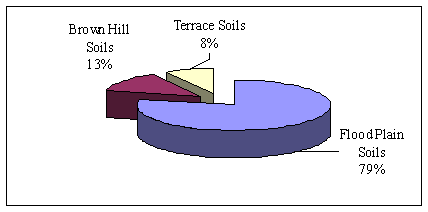
Fig. 1. Coverage of three soil types
Soil scientist usually classify "Flood Plain Soils" of Bangladesh into fourteen sub-types varying from calcareous to non-calcareous, Acid basin to Acid sulphate, Grey to brown Piedmont, Peat and Terai Soils. The "Brown Hill Soils" are spread in the hilly regions of Chittagong, Dhaka and Sylhet districts and vary from brown sandy loam to clay loam. The "Terrace Soils" exist in the "Barind" and "Madhupur" tracts of Bangladesh and consists of brown to grey clays and loams.
Most of the country lies in the delta of three of the world's major rivers. A few small tracts of higher land occur in Sylhet, Mymensingh and Chittagong Hill Tracts regions. Maximum elevation is 850 m on Bangladesh-Myanmar border. The south-western region consists of a large number of dead and cutoff rivers, the coastal part of which includes the famous Sundarbans mangrove forest. Within greater Sylhet and Mymensingh districts lie a number of depressed basins that get inundated by fresh water during the monsoon and gradually dry out during the dry winter season.
Except for small higher areas of old alluvium, rising to about 30m, in the north-west (Barind tract) and north-centre (Madhupur tract), the Ganges-Brahmaputra deltaic plain region is a flat surface of recent alluvium, having a gentle slope and generally with an elevation of less than 10 M above mean sea level. In the north-east (Sylhet) and south-east (Chittagong hills) region, the hilly ridges run mainly north-south and form part of the mountain divide between Myanmar and India. In north-eastern part and to the east of Madhupur lies the North-eastern Lowland. It encompasses the southern and southwestern parts of the Sylhet area (including the valley plain of the Surma River) and the northern part of the Mymensingh area and has large number of lakes. The far north-east region has Sylhet Hills that consist of a number of hillocks and hills ranging from 30 to 40 m in height. Similarly, the south-eastern is dominated by the Chittagong Hills that has many hills, hillocks, valleys, and forests and is quite different in many aspects from other parts of the country. The coastal plain region of Bangladesh is partly sandy and saline. It varies in width from 1 to 15 kilometers. The region has a number of offshore islands and one coral reef, St. Martin's, off the coast of Myanmar (EB, 1999).
None of the major rivers of Bangladesh originates within its territory. The country has five major river systems: (a) The Ganges or Padma and its deltaic streams, the Meghna and the Surma river system, the Jamuna and its adjoining channels, the North Bengal rivers, and the rivers of the Chittagong Hill Tracts and the adjoining plains. The Ganges River system is divided into two segments, the Ganges and the Padma. The Meghna river is the union of the Sylhet-Surma and Kusiyara rivers. The Jamuna and its adjoining channels span a large area from north-central Bangladesh to the Meghna River in the southeast. The Tista is the most important water carrier of north-western Bangladesh that meets the Jamuna. The Feni, the Karnaphuli, the Sangu, and the Matamuhari are the four main rivers that constitute the river system of the Chittagong Hills and the adjoining plains of Bangladesh
Bangladesh enjoys a sub-tropical monsoon climate characterized by rain-bearing winds, moderately warm temperatures, and high humidity. The annual temperature averages between 70C to 360C. April is normally the warmest and January is the coolest month. Storms of very high intensity often occur in the early summer and late in the monsoon season.
Researchers carve out zones along dimensions of their interest and these boundaries serve the purpose for which they are drawn. The Bangladesh Agricultural Research Centre (BARC) classifies Bangladesh into 29 zones along its physiographic dimension and in 92 zones along its agro-climatic dimension. These agro-climatic zones have been developed on the basis of length of the kharif (wet season) growing season, the pre-kharif transition period, the cool winter period, and the summer period.
Based on rainfall Bangladesh can be stratified into three zones. Areas receiving average rainfall between 1,500 to 2000 mm, 2000 to 3,000 mm, and more than 3,000 mm. Most of the country receives more than 1,500 mm of rainfall. Large areas of the south, southeast, north, and northeast Bangladesh receive from 2,000 mm to 2,500 mm of rainfall. The northern and northwestern parts of the Sylhet area receive from 3,500 mm to 5000 mm of rainfall.
On temporal scale, about eighty percent of the rainfall occurs during the monsoon period, from June to September or early October. During last decade, the annual average rainfall has varied between about 1900 mm to 2800 mm and shows a declining trend over last ten years (Figure 2).
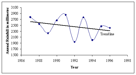
Fig. 2. Rainfall pattern in Bangladesh during last one decade
Champion, Seth and Khatak (1955) develop five main boundaries or types (Tropical Wet Evergreen, Tropical Mixed Evergreen, Tropical Moist Deciduous, Tropical Open Deciduous, and Mangroves) for classifying the forests of Bangladesh. While FMP, 1992 follow the natural divisions (Hills, Plains, Swamps) that represent not only different types of vegetation but also the societies, which reside within or near them. They group forest into three spatial zones; (a) Hill forests in Chittagong hill tracts, Chittagong and Sylhet, (b) Plains inland Sal forests in central and northern zones, and (c) Swamp - Littoral Mangrove forests in delta and coastal regions.
Parliamentary democratic government system governs Bangladesh. The government consists of council of ministers headed by a Prime Minister. The country has unicameral national legislature called "Jatiya Sangsad" with 330 members. The Supreme court at national level and High courts at sub national level provide judicial governance to the country. The Planning Commission provides economic governance at the national level through control of sectoral outlays and setting of investment priorities.
For administrative governance, the country is divided into six administrative divisions that supervise 64 Zila (districts). Each Zila is divided into number of Thanas (block). There are about 490 thanas. Each Thana is divided into Union Parishad, representing a group of villages. Limited local governance is with the people through Union Parishad at village level, Thana Parishad at Thana level, and Zila Parishad at Zila level (SYP, 1997).
Non Governmental Organizations (NGOs) are rebuilding the country by improving local capacities and empowering people for local and social governance. Bangladesh has a good network of NGOs. Many NGO are working on local natural resources, for example more than 500 NGOs are implementing programs relating to afforestation in rural areas. At present there is no centralized mechanism that coordinates efforts of these NGOs.
Religious governance derives from Islam, which is state religion though a constitutional amendment in 1988. More than 85 percent of the population follows Islam,. Socially, Bangladesh is a melting pot of races and economic classes. The genetic roots lies in Proto-Australoids, Mediterranean Caucasoids, Armenoids, and persons of Arab, Persian, and Turkish origin. Most of the tribal people are non-muslims like those in Chittagong Hill are predominantly Buddhist, and those in other parts include the Santals, the Khasis, the Garo, and the Hajang (EB, 1999).
This chapter attempted to provide information that is necessary to understand the constraints that govern the changes in forest pattern over space and time. For this purpose the chapter presented variations in geology, soil, topography, climate, ecology and social and political governance of Bangladesh.
