![]()
![]()
![]()
by
D. Nyeko
Abstract This report describes observations made at some fish landing sites on Lake Albert in order to better understand the statistical data collection process being practised at that level. Special attention is given to procedures for sample selection of fishing units for catch measurement. Recommendations for improvement of practices and procedures are given. | |
| Entebbe | September, 1991 |
1. Introduction
A Catch Assessment Survey (CAS) was launched on lake Albert at the beginning of June 1991. This survey is aimed at providing reliable monthly estimates of catch by species for the lake.
Fish landings were visited from 23rd to 29th August 1991 to check on the implementation of CAS. Landing sites are important elements in the CAS design: they are the Primary Sampling Units (PSUs). They are composed of clusters of fishing units that are considered to be representative of any such unit within a particular minor stratum.
Fish landings sites are therefore an important, integral part of the catch estimation procedure whose nature and dynamics ultimately influence catch estimates. An attempt was made to study their characteristics and the measurement approach undertaken by the field staff in order to recommend ways to improve on the reliability of estimates.
2. Observation at Landings
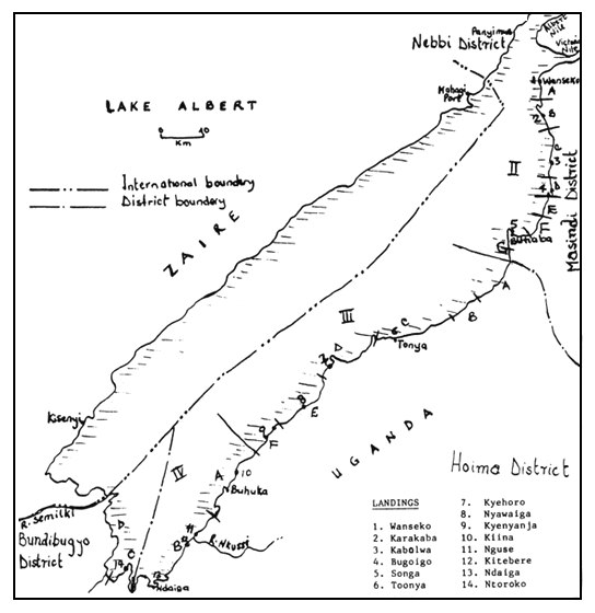
The following observations were made at 13 landings visited during the trip as per itinerary provided in Appendix I. The landing sites covered during the trip with their respective strata are shown in Fig. 1.
2.1. Wanseko Landing:
2.1.1. General
Wanseko landing constitutes a single minor stratum, II-A. The landing site is 300 meters in length and lies adjacent to the confluence of Lake Albert and two rivers, namely the Victoria Nile and Albert Nile. This is bound to have some riverine influence imparted on its fishery. Aquatic macrophytes surround the landing leaving a narrow outlet to the lake.
2.1.2. Statistical Collection
There are two resident staff at the landing who are responsible for the collection of statistics and carrying out extension duties. The senior staff has a supervisory duty and is responsible for checking CAS1 forms filled in by his junior officer.
The junior officer collects statistics at the landing once every other day according to the sampling scheme predetermined from Headquarters. He visits and collects data on boats that land when he is around on the sampling day. Fish landed is separated by species; wrapped in polythene; and weighed in batches using the Salter 100 kg. capacity balance. The catch figures per species are recorded on a rough note pad and transferred to CAS1 forms at the end of the sampling day.
The catch landed is already removed from the nets offshore. This facilitates the data collection process and allows for quick measurement of catch.
2.1.3. Other Characteristics
Fishing boats in use have a length range of 4.5 – 5 meters and are used to fish in the shallow and sometimes swampy surroundings. A substantial number of fishing boats (20 %) did not fish on the day of the visit. The proximity of both Nile systems makes that at least 19 % of the boats fished in the Victoria Nile river at the time of the visit.
The landing time for fishing units varies depending on the target species. Those targeting for the anadromous Alestes spp. using 2 – 3" stretched meshed nets set their nets along the Victoria Nile from 12:00 – 1:00 pm. and land their catch by 6:00 pm.; most fishing (89%) is from the lake and catch is landed between 7:00 and 11:00 am. in the morning.
2.2. Kabolwa Landing:
2.2.1. General
This is the principal landing in minor stratum II-C with 84 fishing canoes in use. The landing is situated in a shallow and muddy shoreline with swampy surroundings. The 50 meters stretch, constituting the landing, needs improvement in drainage or alternatively a pier extension into the shallow water for improvement in fish handling and to ease statistical data collection. Most incoming boats stop some distance from the shoreline due to the mud.
2.2.2. Statistics Collection
The staff at the landing was absent for several days at the time of the visit and omitted two sampling days. The RFO was informed to advise his staff to always delegate responsibility to a nearby staff in case of emergency.
2.2.3. Other Characteristics
General observations indicate that most boats are “barque” flat-bottomed canoes, 4.5 – 5 meters in length; also 5 Kabalega canoes of approximately 9.5 meters were in operation solely for beach seining.
2.3. Bugoigo Landing:
2.3.1. General
Bugoigo landing constitutes a minor stratum (II-D) on its own owing to its size and large number of fishing boats put at a figure of 85 (UGA/87/007 BIOSTAT GROUP, 1991). The shoreline length of the landing is estimated at 700 meters, covered by tall aquatic macrophytes at certain places.
2.3.2. Statistical Data Collection
The macrophytes patched along the shoreline hinder statistical collection. Boats coming in to land their catch may not be easily spotted from any given point. A resident fisheries staff is responsible for data collection. Landed catches are sampled provided they are landed when the staff is around. The staff at the landing was advised to limit data collection within the boundary delinated for the minor strata so as to avoid overlap. Boats noted as landing at the time of the visit (mid-day) were not being sampled. The staff was also advised to work out a definite sample selection procedure for landing boats in order to avoid bias. Landing points could similarly be limited to a restricted manageable space for the purpose of data collection before boats can disperse.
2.3.3. Other Characteristics
Fishing boats are mainly of the “barque” type, between 4.5 – 5 meters in length; a small number of fishing boats (13%) are Kabalega type boats used for beach seining and transport.
2.4. Songa Landing:
2.4.1. General
Songa is one of the landings of the Butiaba complex, located in minor stratum (II-G). It covers approximately a 300 meters stretch of sandy shoreline.
2.4.2. Statistical Data Collection
A fisheries staff assigned to cover this landing, and 3 other landings also located in the same minor stratum, had already finished data collection by the time of the visit. He samples catch at the landing when it falls on a predetermined day of the month, according to the sampling scheme.
2.4.3. Other Characteristics
Owing to the collapse of a nearby landing (Severinos' camp) in the same minor stratum, the affected fishing units shifted to this landing. Consequently, the total number of fishing boats have increased to 35 compared to 29 recorded during the Frame Survey (UGA/87/007 BIOSTAT GROUP, 1991).
2.5. Toonya Landing:
2.5.1. General
Toonya is one of the 13 landings constituting minor stratum III-C. It is located on a sandy plain of the steep rift with a river, the Wambabya nearby. This river creates a swampy floodplain before it joins the lake.
2.5.2. Statistical Data Collection
There are two staff covering this minor stratum. They divide the workload between themselves. Boats land with catch still in the net; consequently a lot of time (sometimes 2 hrs.) is spent to remove the fish from the net. The staff collecting data has to wait until catch is removed from a particular boat before going to the next. There is therefore no definite procedure followed by staff as to the order of landing for sample selection of boats. This ultimately depends on how long the staff takes in completing data collection for one boat.
2.5.3. Other Characteristics
All boats are of “barque” or “Kabalega” type designs with lengths ranging between 7 to 9.5 meters. Each boat carries a large quantity of nets (60 to 400 pieces) of mainly 2" stretched mesh. The predominant fish species landed here is Hydrocynus spp., measuring between 20 to 30 centimeters. A boat carrying 71 nets was observed to have landed 86 Hydrocynus spp. Local variation in the fishery is observed since fisherfolk of the nearby landing of Kyehoro are targeting for Tilapiine and Lates spp. because of the presence of extensive lagoons.
2.6. Kyehoro Landing:
2.6.1. General
The landing occupies approximately 100 meters along the shoreline. It is located in minor stratum III-D and has 19 fishing barques. This makes it the second largest in this minor stratum after Kijangi landing.
2.6.2. Statistical Collection
There is one staff resident at this landing and, together with another staff residing at a nearby landing, they are responsible for 9 other landings within the minor stratum. These two officers are both involved in the collection of statistics at the landings and have divided the workload between themselves following the sampling scheme. At the end of the month, they sit together and compile the CAS2 forms; one officer is responsible for submission of the returns to the Masindi Regional Fisheries Office (RFO).
Sampling procedure for landing boats is difficult to predetermine owing to differences in landing time. Units targeting for Hydrocynus spp. land from early to mid-morning (6:00 – 10:00 am.) ; those fishing with long-lines land in the evening (5:00 – 6:00 pm.); and others land their catch at night. During the sampling day, catch is recorded from morning hours to mid-night. The staff waits for the boats to land before weiging and counting the fish by species. The fish caught is already removed from the nets on-water from 3" stretch mesh and above. It was noted that when many boats land at a go, and owing to the perishable nature of catch, the fishermen immediately begins to split the fish for drying leaving no chance to collect data.
Incorrect identification of species was observed in a case where a staff was mistaking Auchenoglanis spp. for Synodontis spp. The staff was explained on how the two genera are differentiated and he was advised to communicate that to his partner.
2.6.3. Other Characteristics
Fishing boats in use range between 8 – 9 meters in length. They use long-lines and gill-nets of 3" stretched mesh or above to target for Lates spp. Those targeting for Hydrocynus spp. use 2 and 2.5" stretched mesh.
2.7. Nyawaiga (B) Landing:
2.7.1. General Characteristics
Nyawaiga (B) is located in minor stratum III-E near the point where the rift; the valley; and the lake meet. It recently absorbed fishing units from Nyawaiga (A) landing, thereby increasing the number of fishing barque boats from 2 to 7. A Fisheries Department uniport at the landing is accomodating one staff.
2.7.2. Statistical Collection
There are two resident staff at the landing who cover another 10 landings within this minor stratum. These two officers are both involved in the collection of statistics at the landings and shared the workload amongst themselves. It was reported that the three landings of Sebagoro (A), Sebagoro (B) and Sebagoro (C) have combined into Sebagoro (B).
All canoes come with their catch already removed from the nets, making the data collection process easier to deal with. Fishing boat sample selection procedures at landings are a problem when there are strong winds and fishermen drift with the wind for safety and land their catch at any point nearby.
Sample selection procedures for landing boats are difficult to predetermine owing to differences in landing time. In Nkondo area, the beach seiners land their catch throughout the day and night; long-liners land between 11:00 am and 4:00 pm. ; the Hydrocynus gill-net based fishery land their catch from 4:00 to 8:00 am. in the morning. Catch is landed around mid-day during windy days. The various landing times means that the staff has to be at the pre-selected landing before 7:00 am. because any delay would mean finding catch already split for processing. Generally, the staff wakes up early at around 5:30 am. and leaves for the pre-selected landing with a note pad or piece of paper and a weighing scale. On arrival, he enquires whether some boats have already landed. If none had landed, he waits and advises persons at the landing not to tamper with catch before data is collected. When the boats land, all are covered owing to their manageable number. Catches landed at night and those from beach seines landing at illicit points are largely not covered. It was noted that owing to poor catch at times, precision in weight measurement becomes a problem because the scales provided may not give accurate measurement for small samples.
2.7.3. Other Characteristics
A problem arises when many boats land at once and owing to the perishable nature of catch, the fishermen immediately begin to split the fish for drying, leaving no chance to collect data.
2.8. Kyenyanja Landing:
2.8.1. General
Kyenyanja landing is located in minor stratum III-F and has about 500 meters of sandy coastline surrounded by high escarpments. Access to this remote landing of 7 canoes is only by water. The staff covering this landing is resident at Kiina (A).
2.8.2. Statistical Data Collection
Owing to the location of this landing, the staff must use a boat during his visit. Since there is no official boat allocated to the minor stratum, it becomes imperative that he borrows one.
2.8.3. Other Characteristics
A large quantity of Lates albertianus; immature Lates niloticus and Bagrus were seen salted/sundried on the racks. Fairly good catches of Bagrus bayad, using hook-lines, were observed.
2.9. Kiina (A) landing:
Kiina (A) lies in a stretch of shoreline where movement by a resident staff is only possible by boat in order to visit 14 other landings of minor stratum IV-A with similar on-land inaccessibility. The resident staff at the landing rely on borrowed, peddled canoes from fisherfolks for his duties. He was not available at the time of visit and was absent during 2 designated sampling days.
2.10. Nguse Landing:
The landing, located in minor stratum IV-B, has 19 boats and is adjacent to where Nguse river falls from the high escarpment. Access to this landing is only by water. The fisheries staff covering the landing resides in Kitebere.
2.11. Kitebere Landing:
Kitebere is the largest of the landings of minor stratum IV-B with over 30 fishing canoes. There is one resident staff on this landing and he is responsible for data collection schedules in 6 landings of the minor stratum. Owing to the sheltered nature of the fishing grounds, the boats are noticeably smaller in size (5 – 6.5 meters).
2.12. Ndaiga Landing:
2.12.1. General
Ndaiga is located at the southern most end, where the lake shore curves northwards to Ntoroko, having 14 fishing canoes (UGA/87/007 BIOSTAT GROUP, 1991). It is the third largest landing in minor stratum IV-B (in terms of total number of fishing boats) after the landings of Kitebere (32) and Rwabigongoro (23). The landing is about 200 m in length, with 3 landing points separated by tall water weeds. Boats at the landing were observed to range between 6 to 7 meters in length.
2.12.2. Statistical Data Collection
It was established that the landing of Muzizi (D) was now obsolete. The one boat at that landing had moved to another landing in the minor stratum. A resident staff found at Ndaiga landing covers the minor stratum together with another one residing at Kitebere. The CAS2 forms are compiled by either one of them at the end of the month. They alternate in forwarding the returns to Masindi RFO.
Data collection procedures at landings are different. The landings are said to have “few” boats and the staff therefore sample as many as time allows them.
2.13. Ntoroko (C) Landing:
2.13.1 General
It is one of the largest landings on Lake Albert with 98 fishing canoes. The landing is located on a one kilometer long shoreline, facing a calm Bay of the lake.
2.13.2. Statistical Data Collection
Ntoroko (C) lies in minor stratum IV-C, together with 4 other landings and is allocated the most intensive sampling scheme (scheme 1). The data collection procedure is that all boats have to land at an established point before dispersing. The staff, together with the fisherfolks committee, enforce this rule. The number of canoes to sample is pre-selected and the order of landing (arrival) of fishing boats is used in sample selection. A lay person was trained by the staff to carry out the data collection exercise whether staff is away or not.
Catches are landed throughout the day: long-liners land between 12:00 – 3:00 pm.; deep-set gill-nets land between 12:00 – 3:00 pm.; and beach seiners land from 6:00 to 7:00 am. and from 1:00 to 2:00 pm. The trained lay staff stays at or near the landing place throughout the day.
3. General Observations and Recommendations:
The following are some general observations made at the landing sites visited and recommendations for improvement:
There is a general lack of established procedures of sample selection of incoming boats. It is only based on local situation for most landings sites. This is even more true for large landings that are essential to production and where randomisation is important for reliability of estimates. Measurement of catch should be taken from all incoming boats in a fish landing site with 10 boats or less. The landing of catch at night should be discouraged since this catch can not be recorded.
Knowledge of different boat landing times is important so that the staff do not sample only from fishing units using on a particular fishing method and whose landing time is convenient for them. Anyway, a fisheris staff is expected to be at the landing when the first fishing boat lands; and to leave after the last one during a data collection day.
Boats that fish outside delineated lake Albert boundary should need not be considered. This was observed in Wanseko where 19 % of the boats fish along the Victoria Nile, specifically for Alestes spp. Their catch should be included in the estimate for the Victoria Nile.
The observed wrong identification of species calls for more refresher courses, workshops and seminars to improve on this aspect. A wrongly identified species will lead to distortion of estimates by by species. This is especially true for Lake Albert where there is a high diversity in species composition.
There is always a certain fraction of boats which do not go out to fish on any given day, e.g. Wanseko where at least 20 % of the boats did not fish on the day of the visit.
Due to the physical nature of some large landing sites, there is a need for cheap infrastructural development, e.g a pier extension for Kabolwa landing to facilitate data collection and better handling of catch. Where there is a long stretch of shoreline, e.g. Bugoigo and Karakaba, organisation of fisherfolks to land their catches at a specified point before dispersing, as witnessed in Ntoroko, is essential to organise data collection procedure at landings.
Strict observance of sampling schemes and guidelines as stated in the training manual need to be adhered to strictly (Appendix II). A non sampling rate of 14% was observed for the the strata covered during the field visit. This usually leads to faked entries or “curb-stoning” on the part of the absentee staff when returns are submitted. Occasional suprise CAS field checks by the RFO and/or Headquarter personnel are essential for sustananing data quality. The training of lay persons to collect data for trained fisheries personnel at assigned landing sites, e.g. Ntoroko, needs to be looked into or discouraged altogether.
Availiability of adequte transportation means to and from a data collection place is essential for those strata with difficult terrain. It is recommended that strata III-F, IV-A and IV-B are to be equipped with one motorised canoe for on-water transport.
Literature Cited
1. UGA/87/007 BIOSTAT GROUP, 1991. Preliminary Results of the Frame Survey Conducted in the Ugandan Portion of Lake Albert (29/01 – 26/02/1991). FAO/UNDP/UFD FISHIN BIOSTAT No. 23 : 20p.
APPENDIX I:
ITINERARY
| Date | Activities | |
| 1. | 23/08/91 | Left Entebbe for Masindi. |
| 2. | 24/08/91 | Left Masindi for Wanseko landing; also visited Karakaba and Kabolwa landings. |
| 3. | 25/08/91 | Left Wanseko for Masindi; visited Bugoigo and Songa landings |
| 4. | 26/08/91 | Left Masindi for Toonya landing via. Hoima and Buseruka. |
| 5. | 27/08/91 | Left Toonya for Nyawaiga (A) landing; visited Kyehoro, Songa-mari and Nyawaiga landings |
| 6. | 28/08/91 | Left Nyawaiga for Ntoroko (c) landing; visited Kyenyanja, Kiina (A), Nguse, Kitebere, Ndaiga landings |
| 7. | 29/08/91 | Left Ntoroko (C) landing for Masindi. Stop-over at Kitebere, Nyawaiga, Kyehoro, Toonya and Hoima. |
| 8. | 30/08/91 | Left Masindi for Entebbe. |
APPENDIX II:
CATCH ASSESSMENT REFRESHER COURSE FOR LAKE ALBERT FIELD PERSONNEL
Introduction
This manual is expected to assist you in the technical implementation of the re-designed Catch Assessment Survey (CAS). The re-design divided Lake Albert into 4 parts (Strata). These strata were further divided into 21 minor strata. Each of you has been selected from one of these substrata. In cases where there are two staff within one substratum, the one who is attending this re-orientation course is expected to explain the re-design to the other staff. Be advised that you are expected to liase closely with the RFO in both matters of technical and of administrative nature. You are further advised to avoid faking entries or “curbstoning” as this is detrimental to reliable statistical estimates and indeed an abuse of your technical integrity.
Materials Provided for CAS
Calendars
Calendars for the months of June, July and August 1991 are provided. This will serve as a schedule for implementation in each month. It represents two levels of temporal sampling intensity. The majority of minor strata have been allocated Scheme 2 where a pre-selected landing is visited every third day. Some minor strata were allocated Scheme 1 (every second day) and are mainly large ones with a resident staff. It is emphasised that these must be adhered to closely as surprise checks at particular landings may be carried out by the RFO or HQ personnel to ensure reliability of estimates.
List of Pre-selected Landings
The date of visit to the pre-selected landing and identification information (map code & Parish) thereof is attached covering the three months. This should guide you and allow you to plan ahead your activities in the course of the said period. As emphasised above, any deviation from this schedule, can only be with advance authority from the RFO. He will be expected to communicate this to the HQ.
Major Stratum Maps
These maps are designed to aid your planning and scheduling activities. The map code of all the landings in the stratum and the sub stratum demarcated boundaries should aid accurate areal identification to reduce overlap. Where the boundaries are not clear, it must be resolved in this workshop or by the RFO in future. Where new landings are observed or old ones that may have become obsolete, you are expected to report to the RFO such changes so that he can communicate to HQ. This is important since such updates essential to the catch estimation procedure.
Summary Inventory Information
Each substratum inventory of fishing factor/unit characteristics is annexed. It consists of identification information (Stratum characteristics, Landing, Parish and Map code). The core information which you must constantly update and communicate are: # Active canoes, Transport canoes, Fishing canoes, Dug-out canoes and powered canoes by landing.
Catch Assessment Forms
You will be provided with the following forms, similar but nevertheless different in several aspects from the ones hither to used:
CAS1 : Daily landing statistics
This is used for daily statistics for one sample landing.
CAS2 : Summary Form of daily landing totals for a Sub-stratum (Minor stratum).
This form is completed with the totals of CAS1 for each of the surveyed landings during 1 month. It must be emphasised that the RF1 should not be entered as already computed figures i.e. 10/2 and NOT 5.0.
Hints:
Follow your sampling schemes to perfection. If not report this to RFO.
Under no circumstance should pre-selected landings be substituted for convenience.
Avoid faking or “curb-stoning”; enter what you observe, without attempt to manipulate figures.
Paginate correctly for CAS1 in case more than one form is used on a single landing-day.
Hand over all forms for the month (CAS1 & CAS2) to the RFO promptly at the close of each month.
CAS2 forms must be relayed to HQ by the RFO and NOT by individual field personnel
Write a brief report to the RFO to accompany the statistical returns.
Plan your logistics for next survey rounds. Effective planning is the basis for successful execution.
Fig. 1
Landings Visited by Strata
![]()
![]()
![]()