![]()
This report gives a preliminary account of the pollution of land and streams in the catchment of the Anzali Lagoon, Iran. It is based on a visit to the lagoon by the aquatic pollution consultant, and it takes into account the modification of the work plan as prepared by the Technical Adviser (Dr. J. Holcik) during his first visit to this lagoon (see Working Document 1).
After the visit of Dr. Holcik to the project area in 1989, the work plan of the aquatic pollution consultant was divided into two, one man-month missions, of which the first was carried out in March/April. The second mission is planned for August 1990.
The terms of reference are as follows:
collect data for and prepare a pollution source chart comprising:
location of industrial, domestic and agricultural pollution activities;
type, total load and levels of pollutants in the effluent or wastes discharged from each of the charted activities:
the maximum allowable recommended concentrations for each of the listed pollutants, acceptable to fisheries in local situations;
advise on procedures and methodologies for the treatment of effluents known to be harmful to fisheries;
design for the execution by national staff, monitoring of the distribution of pollutants and their harmful effect on the ecosystem;
prepare procedures and methodologies for monitoring of selected pollution parameters including the presentation and interpretation of the collected data.
produce a mission and technical report on his contribution to the project.
The Aquatic Pollution Consultant is responsible to the Technical Adviser for his assignment.
The Aquatic Pollution Consultant visited Iran from 27 March to 16 April 1990 with the following itinerary:
| Arrival | Departure | |
| Szarvas | 19.3.90 | 19.3.90 |
| Budapest/transit | 19.3.90 | 19.3.90 |
| Rome/briefing | 19.3.90 | 26.3.90 |
| Tehran/UNDP | 27.3.90 | 28.3.90 |
| Bandar/Anzali | 28.3.90 | 14.4.90 |
| Tehran/UNDP, Shilat | 14.4.90 | 16.4.90 |
| Rome/debriefing | 16.4.90 | 20.4.90 |
| Budapest/transit | 20.4.90 | 20.4.90 |
| Szarvas | 20.4.90 |
3.1 Persons Met
Mr. Per H. Janvid, UN Resident Representative
Dr. H.R. Ghaffarzadeh, Programme Officer, UNDP
Mr. M.B. Mohri, Deputy Director, Research and Training Division, National
Fisheries Organization/Shilat
Mr. V. Haghpanah, Director, Shilat Fishery Research and Training
Institute in Bandar Anzali/SFRTI
Mr. B. Razavi, Head, Biological Department/BD/SFRTI
Mr. E. Mirzai, Biologist, BD, SFRTI
Mr. S.H. Khodaparast, Head, Chemical Laboratory, SFRTI
Mr. N. Hosseinpour, National Project Director
Mr. M. Karimpour, National Project Staff/NPS
Mr. D. Haghighi, NPS
Mr. H. Jousefpour, Head, Shehidbehesi/Shilat Warm Water Fish Hatchery
During the first mission the Aquatic Pollution Consultant identified and located the domestic, agricultural and industrial pollution activities and collected quantified data for the type, total load and level of pollutants in the different effluents and discharges. He also revised the research work plan and the sampling stations to meet the requirements of the pollution assessment and to provide a data base for a lagoon restoration strategy.
The objectives are as follows:
to maintain and improve the important wildlife function of the lagoon with the aim of maintaining the best habitat for fish, birds, and other organisms
to restore the spawning and nursery function of the lagoon for the economically important anadromous fish.
The strategy for these objectives should be based on maintaining sound watershed conditions. During his first visit the consultant collected all available information on sediments, organic matter, nutrients, heavy metals and pesticides for the Anzali Lagoon watershed and their transport to the lagoon through rivers. The need for collecting data on total suspended sediments, total phosphorous and total nitrogen in the forthcoming period was discussed with the counterpart research laboratory and a programme of sampling was agreed upon. Ten rivers will be sampled by the national staff. Data on total suspended solids, total phosphorus and total nitrogen in these rivers are essential for assessment of the present pollution status and to formulate a strategy for the lagoon restoration. It is expected that after one year of monitoring a diversity of pollution parameters, the resulting information will assist in designing a sound proposal for fish stock and fishery restoration.
Mr. V. Haghpenah, the Director of the Shilat Fishery Research and Training Unit, N. Hosseinpour, the Project Manager, and their staff, fully cooperated in field work and data collection and their assistance was most appreciated. Without their generous help the consultant would have been unable to collect the data for this report.
The lagoon has served for a long time as an important spawning and nursery ground for the economically important anadromous fish. The lagoon also represents an internationally important wildlife reserve and sanctuary with recreational potential, including angling. However the most important function of this lagoon is that it traps sediments from the watersheds of its numerous tributaries.
The present land use in the watershed is sound and well balanced (Table 1). However it could be improved further by rational landscape management. The data collected during the first mission and the proposed follow-up data should lead to a set of recommendations for restoration and management of the lagoon.
A number of streams enter the lagoon. Data on water discharges for the most important tributaries are presented in Figs. 1 and 2. The annual precipitation based upon the average for the period 1964 to 1984 (Table 2) is 1 279 mm. The annual evaporation rate value is 976 mm (Table 2). However, the runoff calculated from the measured discharge value is much higher than the difference between precipitation and evaporation. This could be explained by the same water being diverted for irrigation from the Sefidrud watershed. (Sefidrud does not enter this lagoon. See Fig. 2).
The organic load generated from the watershed is transported by rivers into the lagoon. One important organic source comes from the leaves shed in autumn in the upper watershed area. Forest covers 43.2 percent of the whole watershed. However, the forest is highly degraded with little foliage. Rivers reaching the lowlands mostly flow through barren land without any significant gallery forest. As a result of this the organic load is almost completely decomposed before reaching the lagoon. The second major source comes from livestock. Their number per hectare is low (Table 3). Water buffaloes, sheep, goats and cattle graze over the whole watershed. The third source is a very concentrated pollution load from the food industry. There are 50 food processing plants in the Anzali Lagoon watershed. Most of these plants are small, with only two having more than one thousand workers. They are located on the Pirbasar River watershed. Their sewage discharge is unknown. The fourth and most important organic load source is domestic sewage. Almost half of the total catchment population live in Rasht and Bandar Anzali, both with sewage systems (Table 4). The domestic sewage in these cities is not treated and is discharged directly into the Pirbasar River (Rasht) and the lagoon (Bandar Anzali). There are hundreds of discharges and the amount of the sewage discharged is unknown. The organic load of these cities was estimated by conversion per caput (Table 4). Much of the Rasht sewage reaches the Pirbasar River. Information provided to the consultant showed a rapid decomposition and self-purification rate even in this most loaded river. At 10 km after the pollution point (Rasht) the river recovers sufficiently, as indicated by the relatively low concentration rate of the nitrate nitrogen (Fig. 3).
The organic load from other settlements is mostly untreated, but it does not reach the rivers.
The organic load functions also as a nutrient load. The organic material entering the rivers may be completely mineralized either on land or in rivers, or reaches the lagoon through rivers. In the lagoon, it is either mineralized or increases the nutrient load. If it is mineralized, much of the nutrients are taken up by aquatic plants, and this results in a high plant biomass and extensive vegetation cover. One source of nutrient load is the fertilizer applied for agriculture purposes. The rate of fertilizer application is low, 53.89 kg N ha-1 y-1 (Table 5) as compared to the 100–200 kg N ha-1 y-1 used in western European countries. The third type of nutrient input reaches the lagoon as part of the suspended sediment carried by rivers. The nutrient concentrations transported in this way are not known.
To assess the total nutrient load it is essential to measure the total-N and total-P concentrations in the inflowing rivers. The consultant advised the counterpart's chemical laboratory on sampling and analytical methods and prepared a sampling and analytical programme of work. The nutrients will also be studied for total suspended sediments. Samples will be collected monthly and during each major flood. After completion of nutrient studies, the total nutrient budget, including the watershed contribution, pollution load, decomposition, uptake by macrophytes and other types of organic matter processing in the lagoon will be assessed.
The watershed land use is sound, with 94.8 percent of the total watershed being covered with forest, water bodies and agriculture (Table 1). The broad-leaved deciduous forest on the Talesh slopes of the Anzali lagoon watershed is a relict of the warm temperate forest that covered a large part of Europe and North Asia in the late tertiary and was decimated during the Pleistocene glaciation. Severe cutting and grazing pressure during the last 50 years has degraded much of the forest. The lowland forest has been replaced by agriculture and the whole watershed is overgrazed. Erosion has greatly increased the sediment load in rivers which once harboured rich salmon populations. The two irrigation canals completed in 1965 and 1968 have further aggravated the sediment problem in the Anzali Lagoon. A large volume of water is diverted from the Sefidrud river 362 × 106 m3 y-1 from Tarik reservoir and 1 181 × 106 m3 y-1 from Sangar reservoir and this water transports the highly turbid water to the Anzali Lagoon watershed. The Sefidrud watershed has an extremely high specific sediment yield ranging from 175 to 2 090 t km-2 y-1, and the river has a mean annual suspended sediment concentration of 20.2 g l-1. Thus, in the diverted water the mean annual suspended sediment concentration is much higher than in the rivers draining the basin of Anzali Lagoon. As a result there has been a rapid growth in the river deltas entering the lagoon. The Pashikan River delta is growing at a rate of 100 m y-1 and that of Siadarvishan River at a rate of 110 m y-1. The high suspended sediment load enhances the detoxification process and that of industrial pollutants and pesticides and in this respect is beneficial. Thus, the industrial and pesticide pollution appears to be less serious than the nutrient and organic load. However, the beneficial function of the sediment would work also with much lower suspended sediment concentrations. The adverse effect of the high sediment load on the whole lagoon ecosystem is indisputable and the sediments also carry an additional nutrient load. Measurements of the total-N and total-P on the inflowing rivers will be carried out during the duration of this project by the counterpart laboratory in Bandar Anzali. This high sediment load reduces the water column and supports the establishment of submersed and emergent vegetation to a level unacceptable for fisheries. It can be said that the 1.7 m rise in the water level of the Caspian Sea over the last ten years has contributed to maintaining the Anzali Lagoon in existence.
Foothill damming of the rivers of Pashikan and Siadarvishan offers a feasible temporary alternative to slowing down the sedimentation rate in the Anzali Lagoon basin. These small dams would solve the summer shortage of irrigation water for ricefields originally initiated by the Sefidrud water diversion involving expensive tunnel construction. The existing diversion canal systems can be easily adapted to the proposed dams. The diversion of the rich water sediment from the Sefidrud watershed, where the annual precipitation is low, to the Anzali watershed where there is plenty of water, was an ecological mistake from the point of view of modern knowledge of the landscape and watershed management. Ending the water diversion would significantly improve the sturgeon fisheries on Sefidrud River as well as the important whitefish kutum fisheries on Anzali lagoon.
Records of the total suspended sediment load are poor. What is required are monthly data, especially for each significant flood period for all of the important rivers discharging into the Anzali Lagoon. The laboratory staff in Bandar Anzali have been instructed by the consultant on relevant methods and given a work programme which makes it possible to start collection of data immediately.
Out of the 124 450 ha of total farmland 92 550 ha is covered with ricefields. Most of the land is owned and cultivated by small farmers. Pesticide application is increasing and at present it results in an average yield of 2-2.5 t ha-1. The application rate is 2.5 kg ha of which 1.6 kg ha-1 y-1 is insecticide and 0.95 kg ha-1 y-1 herbicide (Table 6). Around 90 percent of the applied insecticide is the poorly water-soluble diazinon, which, however, has a relatively rapid decomposition rate. Half of the applied herbicide is paraquat and half is glyphosite. Due to the low solubility and the rapid decomposition rate as well as the water saving irrigation method this pesticide load has not represented a direct danger to the lagoon. However the pesticide residues were never measured, neither in the inflowing rivers nor in the lagoon itself. If the rice culture were to result in production of 4–5 t ha-1 y-1 the pesticide application rate would become 8–10 kg ha-1 y-1. It would then become advisable to monitor the residue concentrations in the inflowing river water. At present, the establishment of a pesticide laboratory at the Shilat Institute does not seem necessary as such measurements can be done elsewhere in Iran, for example in one of the university laboratories. The Shilat Research Institute in Bandar Anzali was instructed by the consultant to initiate testing of pesticide toxicity of the inflowing rivers using a short-term static bioassay as described below.
There is little industrial activity in the lagoon's watershed. Only 10.5 percent of the total population of the watershed (Table 7) works in the industry. No data on the discharged industrial effluents character are available. Therefore an indirect approach was used to estimate the industrial pollution load entering the lagoon. This is based on the number of factories, investment (Table 8), size of factories (Table 9), heavy metal concentrations (Tables 10, 11). The number of workers employed by the industries in the Anzali lagoon watershed is rather low. Most of the industrial units are small. There are only 15 factories which have more than 1 000 workers and the total number of workers in industry is only 28 765. However, the number of factories will probably increase, which would also increase the industrial load. The total number of factories was 119 in 1983, 221 in 1985 and 375 in 1989. The increasing rate of industrialization will require more strict pollution controls. During the consultant's visit the distribution of factories was located and mapped (Fig. 4). The overwhelming majority of industrial activities is concentrated on the Pirbasar River with a sizeable solid waste disposal area being located on the upper part of the Siarud River, the largest tributary to the Pirbasar River.
The heavy metal concentrations in the domestic, agricultural and industrial effluents have been measured and are relatively low even in the heavily polluted Pirbasar River (Table 10). Fe,Zn,Pb,Cr,Cu,Ni and Mn concentrations measured in the water of Siarud river immediately downstream of industrial, slaughter house and domestic sewage discharge sites were also low (Table 11). The latter survey covered the whole year except the summer period and although the values were well below the maximum permissible levels, an occasional summer heavy metal stress could not be ruled out lower downstream on the Pirbasar River. The consultant recommended that a summer survey of heavy metal concentrations on the Pirbasar River, when it has the lowest water discharge, be carried out, perhaps with the assistance of a university laboratory. A simple short-term static bioassay has been designed by the consultant to test the water, sediment and effluent toxicity on this river.
From the preliminary estimates of the organic and nutrient load balances it would seem that the lagoon, at least during winter, is not overloaded (Table 12). Estimates of primary production rates are presented in Table 12. The macrophyte cover estimate based on aeroplane and landsat imagery (Table 14) has been used to estimate the nutrient processing capacity of the lagoon. This, together with other data on nutrients which will become available after completion of the surveys on rivers, will make it possible to quantify more accurately the function of this lagoon and assist in the formulation of strategies for its restoration.
In order to meet requirements for a proper pollution assessment in support of the fish stocks and fishery rehabilitation of the Anzali lagoon the following, additional to the Work Plan elaborated by the Technical Adviser during his first mission, was discussed with and included into the work programme of the chemical and biological laboratories:
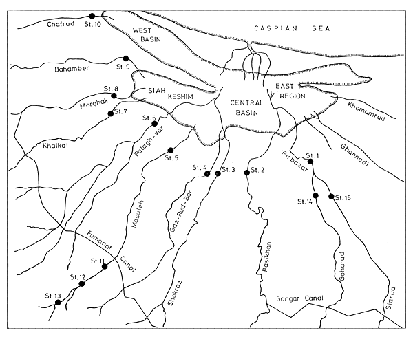
measurement of total suspended solids, COD, total N, NH4-N,NO3-N, total P,PO4-P, in 10 rivers discharging into the lagoon; sampling and measurements to be carried out monthly and during each flood period. Daily sampling and measurements to be carried out during floods on the river Pashikan which transports the highest concentrations of suspended solids. All the methods and facilities are available, and the counterpart staff has been trained by the consultant. Sampling of stations 1–13 has been agreed upon and these stations are marked in Fig. 5.
to substitute the lack of facilities for pesticide and heavy metal analyses a simple short-term static bioassay can be performed by the counterpart laboratory staff. This bioassay should concentrate on the Pirbasar River, which is the most polluted river of the catchment. Sampling stations 14 and 15 are entered on the map (Fig. 5).
as an additional tool for evaluation of the organic pollution, the method of using biological indicators, especially aquatic insects, will be applied, wherever feasible. However, this approach may not work in heavily silted rivers. Sampling methods and insect identification keys have been tested during the visit of the consultant in the field. A bi-weekly sampling on the Masula River (stations 5, 11, 12 and 13) during 1990 should provide the material needed for testing this approach.
The bioassays are conducted to measure the effect of lagoon and river sediments as well as liquid effluents from domestic sewage, animal husbandry, ricefields and, from industry, on one or more species of test organisms. The bioassay of lagoon and river sediments of Anzali has priority in order to determine the magnitude and distribution of the accumulated toxic materials and to predict their potential harm. At present there is no well equipped laboratory available to measure heavy metals using an atomic absorption spectrophotometer and gas chromatography for pesticides. However, it is possible to carry out a simple short-term static bioassay which should help with estimating toxicity of the pollution sources and give reliable information on how dilution decreases or eliminates the toxic effect. Short-term bioassay of 48 or 96 hours is proposed. Long-term tests may involve growth or reproduction as a measure of sub-lethal toxicity. Long-term bioassays require sophisticated flow-through installations and more experience and are therefore at present not feasible. Static bioassays, in which the organisms are kept in the same test solution for the entire experimental period will be carried out by the national staff in their laboratories, as indicated below.
Fish are the major test organisms because of their economic value and importance. Their biology is well known and they are usually sensitive. Yearlings of Rutilus frisii kutum should be tested because of their fisheries importance. In Iran this fish is highly preferred and easily available from hatcheries. Alternative test organisms are: Carassius auratus which are more tolerant, and Cyprinus carpio which are moderately sensitive. The most sensitive invertebrate test organisms like Gammarus (Amphipoda) and Hydropsyche (Trichoptera) and the less sensitive invertebrate test organisms like the red chironomids, Chironomus plumosus (Chironomidae) may be easily collected from the nearby clean mountain streams and from the lagoon itself.
The following instructions are addressed to the counterpart research staff.
Collect fresh sediments using Ekman dredge; collect sewage effluent. Store each sample separately in a plastic container and label carefully. Do not alter the samples by aeration, filtration or addition of chemicals. In the laboratory disperse the undissolved sample with a stirring device just prior to withdrawing samples. Prepare test solutions immediately prior to initiation of the experiment. Test concentrations of effluent or sediment can be easily adjusted or prepared by simple dilution using the same water in which test organisms are kept and maintained or from which the test organisms were collected or by using distilled and aerated water. Diluted water must contain oxygen. Select the dilution concentrations on a logarithmic scale: 1, 1.15, 1.35, 1.55, 1.8, 2.1, 2.4, 2.8, 3.4, 3.7, 4.2, 4.9, 5.6, 6.5, 7.5, 8.7, 10, 11.5, 13.5, 15.5, 18, 21, 24, 28, 32, 37, 42, 49, 56, 65, 75, 87, 100 percent. The number of test or dilution concentrations is usually not more than 4–5 excluding the control without sediment or effluent. The dilution rate depends on the possible toxic effect which can be screened with pre-tests.
Test organisms should be examined for their condition. If many specimens are dying at the end of the holding period of 1–5 days discard all specimens and collect a new population. Use a minimum of 10 organisms per concentration for larger species/young fish/and 20 for smaller species (Gammarus, Hydropsyche, Chironomus). If possible use three replicates for each concentration so that the 95% confidence limits can be determined. The organisms should be randomly selected for particular concentration series in properly sized containers. For invertebrates a large Petri dish or similarly flat container is sufficient and preferable, applying shallow water of 1–2 cm only. Fish can be placed in aquaria of around 10 litres. Check the mortality for the specimens and record the observation daily for 48 or 96 hour test periods. Mortality is the measure generally used in 48 or 96 hour tests. Lack of movement is the most frequently used criterion for death of the tested organisms. Lack of opercular movement in fish is an indication of pending death in fish. Experience in determining death will be gained during the holding, pre-test period as well as the test period itself. The control series (without effluent or sediment) is an essential part of any experiment. Repeat the experiment if more than 10% of the specimens in the control die. Record the number of living and dead organisms in each of the test series and replicates. The 48 or 96 hour mortality data will be utilized in calculating the 48 hour LC50 or the 96 hour LC50 for each replicate series. LC50 is the lethal concentration where 50% die. The test solutions should be disposed of in a safe manner. Test containers must be scrubbed and washed thoroughly to remove all traces of toxicant which may be present in effluent or sediment.
Many different types of data analysis are available to assist in the interpretation of the results. Some of these statistical treatments are easily performed with a hand calculator. The less simple is the arithmetic graphic method. Graph paper is used in this type of analysis with percentage survival plotted on the ordinate against the concentration on the abscissa. Each data point is plotted and connected to form a graph. A horizontal line is drawn from the 50 percent survival point to intersect the plot. A vertical line from the intersection point is then dropped to the abscissa. This intersection point on the abscissa corresponds to the 48 or 96 hour LC50 logarithmic method. This technique of LC50 calculation is similar to the arithmetic method except that semi-log paper (log scale on the ordinate) is used for graphing the results. The concentration is plotted logarithmically along the ordinate axis. This method of calculation is preferred because the concentrations used are based on logarithmic scale.
Table 1
Land use in the Anzali Lagoon watershed
| Land use | Area (ha) | Percentage |
| Barren land | 4 000 | 1.0 |
| Rangeland | 36 300 | 9.7 |
| Forest | 161 920 | 43.2 |
| Ricefields | 92 550 | 24.7 |
| Other agriculture | 31 900 | 8.5 |
| Total agriculture | 124 450 | 33.2 |
| Settlements | 2 600 | 0.6 |
| Anzali Lagoon | 21 800 | 5.8 |
| Reservoirs | 10 000 | 2.6 |
| Fishponds | 1 100 | 0.2 |
| Total water | 32 900 | 8.7 |
| Other land use | 11 830 | 3.1 |
| Total watershed | 374 000 | 100.0 |
Table 2
Monthly and annual average rates of precipitation, evaporation, runoff and discharge for the Anzali Lagoon watershed based on records taken between 1964 and 1984
| Months | Precipitation (mm) | Evaporation (mm) | Runoff (mm) | Discharge 106 m3 |
| January | 115.4 | 30.7 | 42.2 | 158.1 |
| February | 107.0 | 34.7 | 45.1 | 168.7 |
| March | 104.6 | 76.3 | 56.1 | 210.1 |
| April | 68.1 | 91.9 | 64.4 | 241.2 |
| May | 71.3 | 135.3 | 43.5 | 162.7 |
| June | 54.7 | 173.0 | 26.7 | 100.2 |
| July | 51.3 | 152.4 | 21.0 | 78.9 |
| August | 81.0 | 107.4 | 23.6 | 88.6 |
| September | 150.0 | 63.5 | 42.5 | 159.0 |
| October | 184.9 | 40.3 | 52.5 | 196.4 |
| November | 161.9 | 36.6 | 75.8 | 283.6 |
| December | 129.5 | 34.0 | 55.9 | 209.3 |
| Annual | 1 279 | 976 | 549.3 | 2 056 |
Table 3
Livestock, number and densities in the Anzali Lagoon watershed
| Sub-region area | Cattle | Buffaloes | Sheep | Goats | Total | Density (ha-1) | |
| Adjacent to lagoon | |||||||
| 51 750 | 39 583 | 10 529 | 652 | 62 | 50 826 | 0.98 | |
| Altitude -20 to + 100 m above sea level | |||||||
| 154 500 | 188 337 | 3 890 | 28 765 | 12 115 | 233 107 | 1.50 | |
| Foot hills | |||||||
| 167 750 | 41 399 | 178 | 203 230 | 47 109 | 291 916 | 1.73 | |
| Total | |||||||
| 374 000 | 269 319 | 14 597 | 232 647 | 59 286 | 575 849 | 1.53 | |
Table 4
The number and density of human populations living in settlements with and without sewage systems in the Anzali Lagoon watershed
| District | Settlements with sewage systems | Settlements without sewage systems | Total (No.) | Total area (ha) | Density (ha-1) |
| Anzali | 90 063 | 21 997 | 112 060 | 26 112 | 7.29 |
| Somae Sara | - | 132 226 | 132 226 | 49 656 | 2.66 |
| Foman | - | 174 266 | 174 266 | 174 440 | 1.0 |
| Rasht | 354 020 | 93 550 | 447 570 | 69 656 | 6.42 |
| Tavalesh | - | 52 303 | 52 303 | 63 776 | 0.8 |
| Roudbar | - | 2 226 | 2 226 | 2 584 | 0.8 |
| Total | 444 083 | 476 568 | 920 651 | 386 224 | 2.38 |
Table 5
Fertilizer application on the Anzali Lagoon watershed
(métric tonnes)
| Sub-region area (ha) | N fertilizer | P fertilizer | |
| Adjacent to lagoon | |||
| 51 750 | 3 096 | 1 793 | |
| Area from -20 to + 100 m above sea level | |||
| 154 500 | 13 647 | 8 823 | |
| Foothills | |||
| 167 750 | 907 | 475 | |
| Total watershed | |||
| 374 000 | 17 650 | 11 091 | |
| Application rate kg ha-1, y-1 calculated for agricultural area, in terms of N and P | 53.89 | 6.20 | |
Table 6
Pesticide application on Anzali Lagoon watershed, (kg y-1)
| Sub-region area (ha) | Insecticide | Herbicide | Fungicide | Total pesticides | |
| Adjacent to lagoon | |||||
| 51 750 | 38 201 | 24 462 | - | 62 663 | |
| Area from -20 to +100 above sea level | |||||
| 154 500 | 145 748 | 93 220 | 2 595 | 241 563 | |
| Foothills | |||||
| 167 750 | 15 939 | 697 | 139 | 16 775 | |
| Total watershed | |||||
| 374 000 | 199 888 | 118 379 | 2 734 | 321 001 | |
| Application rate kg ha-1y-1 calculated for agricultural area | 1.6 | 0.95 | 0.022 | 2.579 | |
| Type, percentage of pesticide applied | diazinon 90% | paraquat 50% glyphosite 50% | benomile 80% | ||
Table 7
Number of workers in agriculture and industry
| Groups | Number | Percentage |
| Agriculture | 130 156 | 47.5 |
| Industry | 28 765 | 10.5 |
| Other fields | 114 690 | 42.0 |
| Total workers | 273 611 | 100 |
| Total population | 920 651 | - |
Table 8
Number of factories and amount of investment in industries on the Anzali Lagoon watershed, 1989
| Industries | Number of Factories | Investment 106 Riad |
| Textile | 53 | 17 152 |
| Electronic goods | 7 | 7 575 |
| Chemical | 40 | 5 143 |
| Fibre | 152 | 2 760 |
| Building material | 76 | 2 408 |
| Metal goods | 47 | 1 175 |
| Total | 375 | 36 213 |
| Total (1985) | 221 | - |
| Total (1983) | 119 | - |
Table 9
Size of factories (based on number of workers)
| Industries | -10 | Ranges of workers in industrial units | ||||||
| -20 | -50 | -100 | -500 | -1000 | >1000 | Total | ||
| Textile | 3 | 2 | 2 | - | 20 | 11 | 3 | 41 |
| Chemical | 5 | 4 | 4 | 5 | 10 | - | - | 28 |
| Food | 17 | 2 | 7 | 17 | 3 | 2 | 2 | 50 |
| Metal goods | 10 | 8 | 5 | 1 | 10 | - | 8 | 42 |
| Wood | 18 | - | 2 | 2 | 3 | - | 2 | 27 |
| Building material | 14 | - | 5 | - | 9 | 5 | - | 33 |
| Total | 67 | 16 | 25 | 25 | 55 | 18 | 15 | 221 |
Table 10
Heavy metal concentration in domestic, agricultural and industrial sewage effluents (ppm)
| Heavy metal | Domestic sewage | Slaughterhouse sewage | Liquid manure sewage | Electrical industrial sewage |
| Fe | 3.12±0.46 | 4.92±2.8 | 1.34±0.38 | 3.96±2.4 |
| Zn | 0.18±0.18 | 0.85±0.74 | 0.13±0.10 | 0.38±0.05 |
| Pb | 0.09±0.03 | 0.10±0.01 | 0.04±0.01 | 0.15±0.17 |
| Cr | 0.03±0.02 | 0.08±0.06 | 0.01±0.01 | 1.37±1.88 |
| Cu | 0.32±0.3 | 0.11±0.03 | 0.11±0.15 | 0.37±0.49 |
| Ni | 0.06±0.03 | 0.06±0.02 | 0.03±0.01 | 0.19±0.21 |
| Mn | 1.07±0.19 | 0.92±0.24 | 0.41±0.22 | 0.31±0.19 |
Table 11
Annual average of heavy metal concentration (ppm) in the Siarud River draining the solid waste disposal area and flowing through the Gilan District capital, Rasht
| Heavy metal | Solid waste area | Before city | After industrial waste effluent | After slaughterhouse effluent | After domestic sewage effluent |
| Fe | 1.02±0.13 | 2.06±1.32 | 2.5±1.5 | 2.21±1.3 | 2.6±1.9 |
| Zn | 0.07±0.02 | 0.11±0.13 | 0.12±0.05 | 0.09±2.2 | 0.80±0.05 |
| Pb | 0.01±0.009 | 0.04±0.006 | 0.06±0.03 | 0.04±0.01 | 0.07±0.05 |
| Cr | 0.004±0.003 | 0.004±0.004 | 0.05±0.02 | 0.02±0.03 | 0.03±0.02 |
| Cu | 0.01±0.005 | 0.02±0.008 | 0.32±0.27 | 0.27±0.04 | 0.03±0.006 |
| Ni | 0.006±0.001 | 0.02±0.009 | 0.18±0.23 | 0.23±0.01 | 0.01±0.009 |
| Mn | 0.07±0.02 | 0.26±0.1 | 0.32±0.14 | 0.14±0.25 | 0.3±0.17 |
Table 12
Winter nutrient status in Anzali Lagoon (ppm, n = 290)
| Nutrient | Western Basin Abkanal | Eastern Region Sheygan | Southern Region Siah Keshim | Rogas Outlets |
| Dissolved organic carbon | 7.4±1.0 | 7.6±1.7 | 6.2±1.7 | 6.9±0.3 |
| NH4-N | 0.34±0.01 | 0.39±0.15 | 0.34±0.04 | 0.43±0.02 |
| NO3-N | 0.28±0.04 | 0.40±0.27 | 0.23±0.06 | 0.23±0.06 |
| PO4-P | 0.012±0.006 | 0.045±0.044 | 0.018±0.027 | 0.037±0.009 |
Table 13
Estimate of primary production rates in Anzali Lagoon
| Communities | Area (ha) | Production rate g C m-2 y-1 | Total production t y-1 |
| Submersed vegetation | 5 200 | 300 | 15 600 |
| Floating vegetation | 2 000 | 1 100 | 22 000 |
| Emergent vegetation | 11 600 | 1 250 | 145 000 |
| Grassland | 3 000 | 500 | 15 000 |
| Plankton | see submersed vegetation | 100 | 5 200 |
| Total | 21 800 | - | 202 800 |
Table 14
Aerial estimates of macrophyte communities of Anzali Lagoon, based on plane and landsat imagery (km2)
| Communities | 1956 | 1966 | 1976 | 1985 |
| Submersed vegetation | 69 | 50 | 47 | 52 |
| Floating vegetation | 20 | 24 | 24 | 20 |
| Emergent vegetation | 98 | 103 | 110 | 116 |
| Grassland | 50 | 40 | 30 | 30 |
| Total area | 237 | 217 | 211 | 218 |
LEGEND OF FIGURES
Fig.1
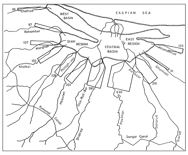
Fig.2
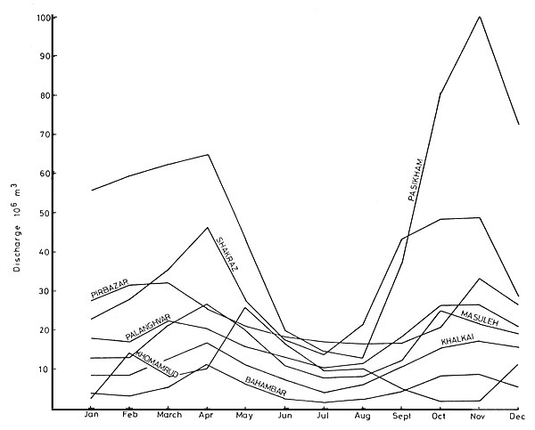
Fig.3
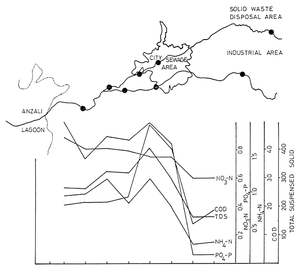
Fig.4
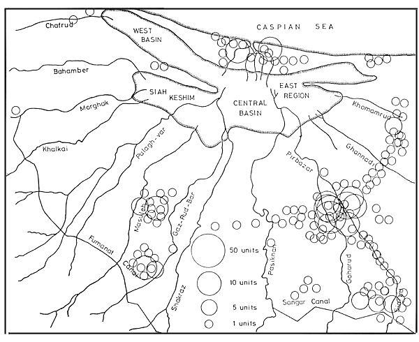
Fig.5
![]()