![]()
Between 18 January and 13 February, 1990, a frame survey (FS) was carried out in the project's working area comprising Lake Malombe, the Upper Shire River and the South East Arm of Lake Malawi (fig.1). The aim of the survey was to collect basic information relating to the size and distribution of the traditional (artisanal) fishery which exploits Chambo (Oreochromis spp. formerly Tilapia spp.) in these areas. The data were also collected to facilitate revision of the catch-effort sampling system and establishment of a base line for the socio-economic study to be carried out in the project area.
Normally, FS is carried out by the Fisheries Department in August during the dry season when it is less difficult to travel to most landing sites than during the rainy season. Therefore, it is envisaged that the data collected in this (January–February, 1990) survey and the one planned for August, 1990, will show what differences in the fishery, if any, exist between the rainy season and the dry season within the same year.
The South East Arm covers an area of approximately 2 000 km2 and is the most productive part of Lake Malawi. This is mainly so as a result of the seasonal hydrological events which take place in the area which lead to an abundant supply of food for the fish (Eccles, 1974). Lake Malombe is about 390 km2 and not deeper than 17 m. It actually is an enlargement of the Shire River, the only outlet of Lake Malawi. The Upper Shire River is 16 km long and connects the South East Arm to Lake Malombe.
The national waters of Malawi are divided into major and minor strata to facilitate collection of fisheries statistics. The divisions are based on limnological and geographical considerations.
Fisheries Technical Assistants were briefed before being assigned to collect FS data from the minor strata(MS) allocated to them. The data collectors were instructed to visit all the fishing sites in the MS and to collect data from only those fishermen who used and/or owned fishing gear known to catch chambo. Therefore, longlines and mosquito nets were not covered by the survey. Data were collected by both interviewing fishermen and direct observation, and were recorded on a standard form (Appendix 1). Data collected included the number and type of fishing gear and craft owned by a fisherman. Where fishing nets were encountered, the following measurements were taken: headline length, depth and mesh size.
Fishing sites
During the survey, a total of 154 fishing sites were visited: 100 in the South East Arm; 8 in the Upper Shire River and 46 in Lake Malombe.
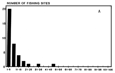
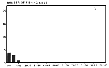
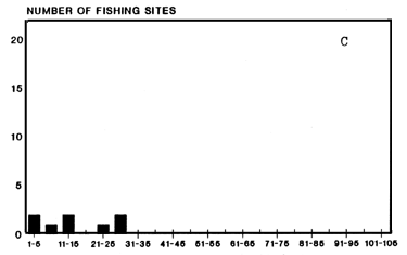
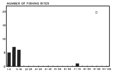
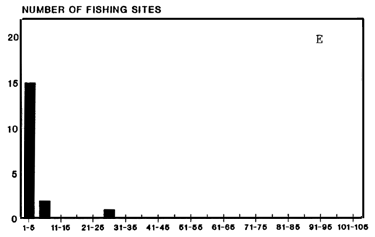
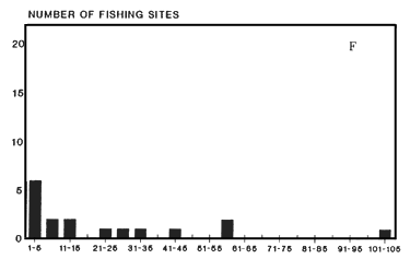
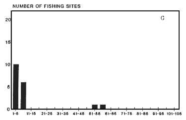
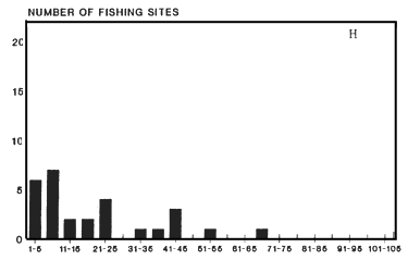
Size-frequency distributions of the fishing sites in each MS covered by FS are presented in Figs 2a to 2h. All, except the one for the Upper Shire River (MS 1.3), were, roughly, of similar pattern with many small fishing sites and fewer bigger ones. A much more uniform distribution was observed in the Upper Shire River (Fig. 2c) with as many small fishing sites as large ones.
Fishermen
We defined a fisherman as a person who owns fishing gear and/or fishing craft and/or is involved in the actual operation of catching fish. By including gear/craft owners who may not necessarily be involved in the actual operation of capture of fish, our definition differs slightly from that given by Bazigos (1974).
Table 1 shows the number of chambo fishermen (gear owners and assistants) recorded from each area covered by the survey. A total of 9510 fishermen were counted. Of this total 11% (1020) owned fishing gear and/or fishing craft.
For the purpose of comparing the intensity of fishing between the areas, the number of fishermen per kilometre of shoreline was calculated. This number was highest (73/km) in the Upper Shire River, about half as much (35/km) in the South East Arm and least (28/km) in Lake Malombe. However, the MS within these broad areas showed considerable differences in this respect (table 1).
Movements of Fishermen
Among the fishermen interviewed during the FS, some were found on fishing sites outside the MS where they reportedly normally carry out fishing. These fishermen had temporarily moved, for one reason or another, from their home fishing grounds. The main movement appeared to have concerned 15 gear owners whose fishing equipment (fishing craft and gear), normally based at Lake Malombe, were recorded in the South East Arm of Lake Malawi. In relation to the total number of fishermen counted in each MS, however, the movement appeared not to be extensive, since only small numbers of fishermen were involved.
Fishing Craft
The number of fishing craft of each type recorded during the frame survey is shown in Table 2. A total of 1861 fishing craft were recorded of which about 38% were dugout canoes. Only 7% were propelled by an outboard engine and none of these were dugout canoes. Dugout canoes constituted 51% of the fishing craft in the South East Arm while only plank boats were recorded from the Upper Shire River. In Lake Malombe, 99% of the fishing craft were plank boats. There were no plank boats with engines in the Upper Shire River while 127 boats with engines were observed in the South East Arm. Only one boat with engine was recorded from Lake Malombe.
The number of fishing craft per kilometre of shoreline (craft/km) can be used as an index of the level of fishing activity and, therefore, as a basis for comparison between fishing areas (Bazigos, 1971). This index was calculated for each surveyed area as another measure of the fishing intensity in the areas. There were approximately 1.5 as many craft/km in the South East Arm as in Lake Malombe while the Upper Shire River had about the same number as in the South East Arm.
The figures in the table below show that there is a clear east-west demarcation which may be linked to better roads on the west side of the the South East Arm of Lake Malawi and Lake Malombe including the Upper Shire River.
| EAST | WEST | |
| Number of fishermen/km | 28.9 | 42.2 |
| Number of craft/km | 5.8 | 8.1 |
| Number of engines/100 fishing craft | 3.4 | 9.6 |
Fishing Gear
Table 3 shows the number and type of fishing gears recorded in the areas covered by the survey. Gillnets were the most numerous fishing gear in the South East Arm and in Lake Malombe whereas Chambo seine nets dominated in the Upper Shire River. Chirimila nets, which were not observed in both the Upper Shire River and Lake Malombe, were the second most numerous fishing gear in the South East Arm. In the Upper Shire River and in Lake Malombe, Nkacha nets were the second most numerous gear. Kambuzi seine nets were recorded in appreciable numbers from the South East Arm and Lake Malombe. Comparatively low numbers of Chambo seine nets were counted from both the South East Arm and Lake Malombe. At the MS level, noticeably large numbers of chirimila nets were observed in MS 2.3 (North-west Boadzulu Is) and MS 2.5 (Makanjira) compared to the figures in the rest of the MS. This may be connected with the fact that the water in these MS is deeper, and of much greater surface area and, therefore, suitable for fishing with an openwater seine net such as the chirimila.
Table 4 to 8 show a summary of the measurements taken from the various types of nets encountered during the FS.
Gillnets
More than 90 % of the gillnets recorded from the South East Arm of Lake Malawi were 800 m or less in length (table 4a), 86 % of the gillnets were of mesh sizes between 81 mm and 100 mm and two thirds of the nets were less than 5.55 m deep.
Only three short gillnets were recorded from the Upper Shire River (table 4b). In Lake Malombe, 90 % of the gillnets were 600 m or less in length (table 4c). Nearly all nets (97 %) had meshes meshes between 61 mm and 90 mm. The mean depth of the nets was about 6.2 m.
Gillnets were generally larger in the South East Arm than in lake Malombe and also had larger mesh sizes.
Chambo seine nets
In the South East Arm, the mean length of chambo seine nets was 634 m, a quarter of the nets were between 200 and 400 m and half of them between 700 and 1000 m (table 5a). The mean mesh size was about 79 mm and the mean depth about 14.2 m. The nets recorded from Lake Malombe (table 5c) were somewhat longer on average (mean = 773 m) but had a smaller mean mesh size (65mm). In the Upper Shire River, chambo seine nets were much smaller with a mean headline length of 227 m (table 5b). However, the mesh sizes were comparable to those recorded from the South East Arm. In Lake Malombe, the mean depth was of the nets (9.6 m) was less than in the other areas.
Kambuzi seine nets
The mean headline length of kambuzi nets from the South East Arm was 96.1 m (table 6a). About 68 % of the nets were less than 100 m and 94 % were less than 200 m long. The mean size of the meshes was 17.6 mm and the mean depth of the nets was 5.8 m with most nets (71 %) less than 6.55m deep. Kambuzi nets recorded from the Upper Shire River (table 6b) were of more or less the same length as the nets recorded from the South East Arm; the mean length of the nets was 113.3 m but when the 300 m-long net was not incuded in the calculation, the new mean (96.3 m) became almost the same as that calculated for the South East Arm. The Upper Shire nets were much less deeper, with a mean depth of 7.2m, but were of larger mean mesh size (19.8 mm). The kambuzi nets recorded from Lake Malombe (table 6c) were generally longer, with a mean length of 282.9 m and most (70 %) nets being of length less than or equal to 300 m. These nets were, generally of the same range of depth as those in the Upper Shire River and the South East Arm. The mean mesh size of kambuzi nets from Lake Malombe was 15.9 mm, somewhat smaller than in the other areas.
Nkacha nets
Measurements of nkacha nets recorded during the survey are shown in tables 7a to 7c. The mean length of nets recorded from the South East Arm was 122.9 m. Few nets (11 %) were longer than 200 m. The mean mesh size was approximately 16.8 mm and most nets (71 %) had mesh sizes less than 21 mm. The mean depth was about 8.6 m. In contrast, the mean length of nkacha nets from the Upper Shire River was 228.4 m and most nets (74 %) were longer than 200 m. However, the mean mesh size (15.1 mm) was smaller. The mean length of nkacha nets from Lake Malombe was 133.4 m with about 10 % of the nets longer than 200 m. The mean mesh size was 10.5 mm and the depth of the nets (mean = 8.8 m) was similar to that of nets recorded from the other areas (8,75 m).
Chirimila
The mean length of chirimila nets was approximately 60 m and 77 % of the lengths varied between 41 m and 70 m (table 8). The mean mesh size was 21.5 mm and 71 % of the nets were of mesh sizes 23 and 25 mm (ie approximately one inch). The mean depth of the nets was about 28.3 m.
Ownership of Gear and Fishing Craft
Appendix 2 shows the number of fishermen reported owning the various types of fishing gears and fishing craft. A fishermen owned either one type of fishing gear or a combination of gear types and fishing craft. Generally, the main difference in the gear/craft combinations observed between the major strata was due to the difference in gear types. For example, combinations involving chirimila nets were only observed in the South-East Arm of Lake Malawi because the gear does not occur in Lake Malombe and Upper Shire River. Between minor strata, there were notable differences in the number and types of gear-craft combinations and their popularity. For example, 49 different combinations were observed in the west of Lake Malombe, the most popular one, a nkacha net and two plank boats, being owned by approximately 21 % of the fishermen. In contrast, there were 17 combinations in the Upper Shire River and fishermen populary owned a chambo seine nets without fishing craft (34 %).
Fishing Units
A fishing economic unit as defined by Bazigos (1974) consists of fishing gear, fishing craft and the men who operate the equipment. The precise nature of the fishing units in the project area was examined using data collected during the FS.
Table 9 shows the various combinations of fishing gear and craft and their frequency of occurrence in the MS. The combinations where gillnets, chambo seine nets and kambuzi seine net were associated with only one fishing craft occurred much more frequently (91, 91 and 71 % respectively) than other combinations. A Nkacha net was most frequently (84 %) associated with two plank boats. The combination of chirimila net with three fishing craft (one plank-boat and two dugout canoes) was the most popular combination (68 %) followed by the combination with two fishing craft (one plank boat and a dugout canoe, 18 %).
Data collected during the frame survey suggest that there are approximately 10 000 artisanal fishermen associated with Chambo fishing in Lake Malombe, the Upper Shire River and the South East Arm of Lake Malawi. Only a small proportion (11 %) of the fishermen own fishing equipment, the bulk being helpers. The fishermen are located in more than 150 fishing sites scattered along the shoreline.
Nearly 2 000 fishing craft are employed, most are plank boats with dugout canoes forming the remainder (about 38 %). Outboard engines are not used extensively (< 7 %).
Gillnets are the commonest fishing gear in the area surveyed whereas handlines and fish traps are very few although the latter two gears might have been underestimated. While chirimila nets are one of the major gears in the area north of Boadzulu Island, they are not important to the south of the island and do not occur at all in Lake Malombe and the Upper Shire river. The substitute for chirimila in the south of Boadzulu Island, Upper Shire and Lake Malombe appears to be the Nkacha net. Chambo seine nets appear to be the major base of the chambo fishery in the Upper Shire River and in the area south-east of Boadzulu Island.
It appeared that movements of fishermen between Lake Malombe, Upper Shire River and the South East Arm are not extensive as only a very small number of fishermen was involved. The movement of some fishermen from Lake Malombe to the South East Arm was most likely linked to the closed season for the Nkacha fishery which was effective in Lake Malombe at the time of the survey.
The results of this survey are more meaningful if comparisons are carried out between minor strata than comparisons between major strata. The differences and similarities between the minor strata, if determined, may then be used as a basis for planning effective data collecting and monitoring programmes.
In this respect, it is clear, judging from the concentration of fishermen per length of shoreline, that fishing is of higher intensity in Lake Malombe West, Upper Shire River and the south of Boadzulu Island in the South East Arm (MS 2.1, 2.2) than in the other areas. The Upper Shire river appears to be the area with the highest fishing intensity.
The concentration of fishing craft (fishing craft/km of shoreline) suggest a similar pattern except that there is a lower number of craft per length of shore in the south east of Boadzulu Island (MS 2.2) and high craft concentrations in the North West of Boadzulu Island (MS.2.3) and Makanjira (MS.2.5). This seeming discrepancy may be explained as follows. The South East of Boadzulu Island is an area where the use chambo seine nets is very common and, obviously, important. These large nets do not require the use of more craft than one but they do require the services of a large number of fishermen to pull the net to the beach. Hence the high concentration of fishermen and low concentration of fishing craft in the area. The observed high concentration of fishing craft in the North West of Boadzulu Island and in Makanjira may not mean high fishing activity but rather reflect the common use of chirimila nets in the areas. A chirimila net requires the use of two to three fishing craft in order to be fished.
Generally, there seems to be a clear east-west division in the project area, the west being of higher fishing intensity than the east.
With exceptions, the number of fishing craft observed on a fishing site may be used as an indication of whether or not adjacent waters are productive or whether or not the site is a good market for fish. The distribution of the sizes of fishing sites in terms of the number of fishing craft counted on the sites indicate that either poor markets or fishing grounds exist in most fishing areas since there are many small sites and less of the large ones. However, there is a relatively large proportion (13%) of large fishing sites (16–20 craft per site) in Lake Malombe West and Upper Shire River (27%). This is likely to be a consequence of the fact that there are good access roads connecting these areas to large markets in Blantyre and Lilongwe and that the areas are relatively good fishing grounds. There are also large proportions of large fishing sites in North West Boadzulu Island (38%) and Makanjira (46%) but these may be attributable to chirimila fishing and may not necessarily mean indication of a productive fishery.
Regarding the fishing units operating in the study area; the fact that gear/craft combinations other than the more frequently occurring ones do exist means that one can not readily define a “fishing unit”. Some combinations are obviously over-equiped and others under-equiped. It is known that the under-equiped ones can still operate by borrowing fishing craft from over-equiped or by temporarily merging with other incomplete fishing units.
Eccles, D.H. (1974). An outline of the physical limnology of Lake Malawi (Lake Nyasa). Limn. Ocean. 19: 730–42
Bazigos, G.P. (1971). Frame survey at Kainji Lake. Statistical Study 1. FAO Pap. No. FI:SF/NIR 24
Bazigos, G.P. (1974). The design of fisheries statistical surveys -Inland waters. FAO Tech. Pap. No. FIPS/T133
Chambo: A group of closely related species of the genus Oreochromis endemic to the Lake Malawi-Lake Malombe system. The species are very difficult to tell apart when not breeding and when young. Some taxonomic work to attempt to solve this problem is in progress.
Chambo seine net: A large beach seine net with relatively large meshes (legal minimum = 89 mm) used by artisanal fishermen for catching chambo.
Chirimila: A seine net used by artisanal fishermen in the open water specifically aimed at the pelagic Lake Malawi sardine (Engraulicypris sardella (locally known as ‘usipa’) and semi-pelagic haplochromines (locally called ‘utaka’). Chambo are caught more or less incidentally by this net.
Kambuzi seine net: A small-meshed beach seine net shorter than an average chambo seine net. The net is aimed at catching a mixture of small haplochromine species locally known as ‘kambuzi’. Chambo are caught as by-catch.
Nkacha net: A net similar to the kambuzi seine net in size, mesh size and construction and, like the kambuzi seine net, it is aimed at ‘kambuzi’. A small amount of chambo is sometimes caught as bycatch. Unlike the kambuzi seine net, the nkacha net operates in the open water.
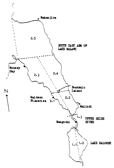
Fig 1. Map showing the project's working area and statistical divisions (minor strata)
Fig. 2. Size frequency distributions of fishing sites for the minor strata (MS) in Lake Malombe (1.1–1.2), Upper Shire River (1.3) and the South East Arm of Lake Malawi (2.1–2.5).
 |  |
| SIZE CLASS OF FISHING SITE | SIZE CLASS OF FISHING SITE |
| MS 1.3 | MS 2.1 |
 |  |
| SIZE CLASS OF FISHING SITE | SIZE CLASS OF FISHING SITE |
| MS 2.2 | MS 2.3 |
 |  |
| SIZE CLASS OF FISHING SITE | SIZE CLASS OF FISHING SITE |
| MS 2.4 | MS 2.5 |
 |  |
| SIZE CLASS OF FISHING SITE | SIZE CLASS OF FISHING SITE |
Table 1. Chambo fishermen counted during a frame survey conducted from January to February, 1990, covering the South East Arm of Lake Malawi, Lake Malombe and the Upper Shire River. Their number per length of shoreline is shown to facilitate comparison between areas.
| AREA | MINOR STRATUM | FISHERMEN | TOTAL | SHORELINE LENGTH(KM) | FISHERMEN PER KM | |
| Gear Owners | Helpers | |||||
| SOUTH | 2.1 | 142 | 1116 | 11258 | 28 | 45 |
| EAST | 2.2 | 64 | 910 | 974 | 25 | 39 |
| ARM | 2.3 | 180 | 1088 | 1268 | 41 | 31 |
| 2.4 | 101 | 786 | 887 | 29 | 31 | |
| 2.5 | 215 | 1686 | 1901 | 58 | 33 | |
| TOTAL | 702 | 5586 | 6288 | 181 | 35 | |
| UPPER SHIRE RIVER | 1.3 | 113 | 1059 | 1172 | 16 | 73 |
| LAKE | 1.1 | 173 | 1534 | 1707 | 43 | 40 |
| MALOMBE | 1.2 | 32 | 311 | 343 | 30 | 11 |
| Total | 205 | 1845 | 2050 | 73 | 28 | |
| GRAND TOTAL | 1020 | 8490 | 9510 | 270 | 35 | |
Table 2. Fishing craft counted during a frame survey conducted from January to February, 1990, covering the South East Arm of Lake Malawi, Lake Malombe and the Upper Shire River (D = dugout canoe, B = plank boat, BE = plank boat with engine). Their number per length of shoreline is shown to facilitate comparison between areas.
| AREA | MINOR STRATUM | FISHING CRAFT | TOTAL | SHORELINE LENGTH(KM) | FISHING CRAFT PER KM | ||
| D | B | BE | |||||
| SOUTH | 2.1 | 53 | 119 | 42 | 214 | 28 | 7.6 |
| EAST | 2.2 | 18 | 60 | 0 | 78 | 25 | 3.1 |
| ARM | 2.3 | 307 | 35 | 57 | 399 | 41 | 9.7 |
| 2.4 | 20 | 116 | 20 | 156 | 29 | 5.4 | |
| 2.5 | 303 | 225 | 8 | 536 | 58 | 9.2 | |
| Total | 701 | 555 | 127 | 1383 | 181 | 7.6 | |
| UPPER SHIRE RIVER | 1.3 | 0 | 112 | 0 | 112 | 16 | 7.0 |
| LAKE MALOMBE | 1.1 | 3 | 312 | 1 | 316 | 43 | 7.3 |
| 1.2 | 0 | 50 | 0 | 50 | 30 | 1.7 | |
| Total | 3 | 362 | 1 | 366 | 73 | 5.0 | |
| GRAND TOTAL | 704 | 1029 | 128 | 1861 | 270 | 6.9 | |
Table 3. Fishing gears recorded during the frame survey of the South East Arm of Lake Malawi, Upper Shire River and Lake Malombe conducted from January to February, 1990 (GN = pieces of 100 m of gillnet; CH = chirimila; CS = chambo seine net; KS = kambuzi seine net; NK = nkacha net; HL = hand line; FT = fish trap).
| AREA | MINOR STRATUM | FISHING GEARS | ||||||
| GN | CH | CS | KS | NK | HL | FT | ||
| SOUTH | 2.1 | 465 | 16 | 13 | 34 | 16 | 0 | 0 |
| EAST | 2.2 | 34 | 14 | 24 | 10 | 7 | 18 | 0 |
| ARM | 2.3 | 298 | 80 | 3 | 40 | 0 | 0 | 0 |
| 2.4 | 352 | 31 | 2 | 12 | 15 | 0 | 0 | |
| 2.5 | 368 | 152 | 7 | 12 | 0 | 0 | 0 | |
| Total | 1517 | 293 | 49 | 108 | 38 | 18 | 0 | |
| UPPER SHIRE | 1.3 | 3 | 0 | 78 | 12 | 34 | 0 | 0 |
| LAKE | 1.1 | 408 | 0 | 10 | 32 | 88 | 0 | 0 |
| MALOMBE | 1.2 | 38 | 0 | 2 | 2 | 13 | 0 | 6 |
| Total | 446 | 0 | 12 | 34 | 101 | 0 | 0 | |
| GRAND TOTAL | 1966 | 293 | 139 | 154 | 173 | 18 | 6 | |
Table 4a. Measurements of gillnets recorded from the South-East Arm of Lake Malawi during the frame survey conducted in January 1990.
SOUTH EAST ARM OF LAKE MALAWI
| Headline length | Mesh Size | Depth | |||
| class size(m) | number of nets | class size(mm) | number of nets | class size(m) | number of nets |
| 1–200 | 67 | 31–40 | 6 | 0.55– 5.55 | 204 |
| 201–400 | 95 | 41–50 | 4 | 5.55–10.55 | 17 |
| 401–600 | 73 | 51–60 | 0 | 10.55–15.55 | 38 |
| 601–800 | 38 | 61–70 | 20 | 15.55–20.55 | 41 |
| 801–1000 | 14 | 71–80 | 18 | 20.55–25.55 | 2 |
| 1001–1200 | 6 | 81–90 | 43 | 25.55–30.55 | 1 |
| 1201–1400 | 2 | 91–100 | 202 | 30.55–35.55 | 0 |
| 1401–1600 | 2 | 101–110 | 8 | 35.55–40.55 | 0 |
| 1601–1800 | 1 | 111–120 | 1 | ||
| 1801–2000 | 1 | 121–130 | 1 | ||
| 2001–2200 | 1 | ||||
| 2201–2400 | 0 | ||||
| 2401–2600 | 0 | ||||
| 2601–2800 | 0 | ||||
| 2801–3000 | 2 | ||||
| 3001–3200 | 1 | ||||
| 303 | 303 | 303 | |||
Table 4b. Measurements of gillnets recorded from the Upper Shire River during the frame survey conducted in January, 1990.
UPPER SHIRE RIVER
| Headline length (m) | Mesh size (mm) | Depth (m) |
| 100 | 76 | 3 |
| 100 | 76 | 2 |
| 100 | 76 | 2 |
Table 4c. Measurements of gillnets recorded from Lake Malombe during the frame survey conducted in January 1990.
LAKE MALOMBE
| Headline length | Mesh Size | Depth(m) | |||
| class size(m) | number of nets | class size(mm) | number of nets | class size(m) | number of nets |
| 1–100 | 20 | 51–60 | 3 | 0.55–5.55 | 16 |
| 101–200 | 18 | 61–70 | 22 | 5.55–10.55 | 103 |
| 201–300 | 32 | 71–80 | 14 | 10.55–15.55 | 1 |
| 301–400 | 22 | 81–90 | 80 | ||
| 401–500 | 3 | 91–100 | 0 | ||
| 501–600 | 13 | 101–110 | 0 | ||
| 601–700 | 1 | 111–120 | 1 | ||
| 701–800 | 7 | ||||
| 801–900 | 0 | ||||
| 901–1000 | 0 | ||||
| 1001–1100 | 1 | ||||
| 1101–1200 | 2 | ||||
| 1201–1300 | 0 | ||||
| 1301–1400 | 0 | ||||
| 1401–1500 | 1 | ||||
| 120 | 120 | 120 | |||
Table 5a. Measurements of the chambo seine nets recorded from the South-East Arm of Lake Malawi during the frame survey conducted in January, 1990.
SOUTH EAST ARM OF LAKE MALAWI
| Headline length | Mesh size | Depth | |||
| class size(m) | number of nets | mesh size(mm) | number of nets | class size(m) | number of nets |
| 0–100 | 0 | 69 | 1 | 0.55– 5.55 | 2 |
| 101–200 | 2 | 72 | 4 | 5.55–10.55 | 9 |
| 201–300 | 8 | 75 | 1 | 10.55–15.55 | 23 |
| 301–400 | 5 | 76 | 27 | 15.55–20.55 | 9 |
| 401–500 | 2 | 86 | 1 | 20.55–25.55 | 3 |
| 501–600 | 3 | 87 | 15 | 25.55–30.55 | 2 |
| 601–700 | 4 | 30.55–35.55 | 1 | ||
| 701–800 | 9 | ||||
| 801–900 | 3 | ||||
| 901–1000 | 12 | ||||
| 1000–1100 | 0 | ||||
| 1101–1200 | 1 | ||||
| 49 | 49 | 49 | |||
Table 5b. Measurements of the chambo seine nets recorded from the Upper Shire River during the frame survey conducted in January, 1990.
UPPER SHIRE RIVER
| Headline Length | Mesh size | Depth | |||
| class size(m) | number of nets | mesh size(mm) | number of nets | Depth (m) | number of nets |
| 101–200 | 23 | 76 | 63 | 10 | 2 |
| 201–300 | 53 | 90 | 15 | 11 | 2 |
| 301–400 | 1 | 12 | 14 | ||
| 401–500 | 0 | 14 | 10 | ||
| 501–600 | 0 | 15 | 49 | ||
| 601–700 | 1 | 16 | 1 | ||
| 78 | 78 | 78 | |||
Table 5c. Measurements of all chambo seine nets recorded from Lake Malombe during the frame survey conducted in January, 1990.
LAKE MALOMBE
N = 12
| Headline length (m) | Mesh size (mm) | Depth (m) |
| 200 | 76 | 11.4 |
| 500 | 70 | 10.5 |
| 588 | 64 | 8.3 |
| 600 | 55 | 7.5 |
| 720 | 64 | 10.5 |
| 721 | 70 | 10.5 |
| 750 | 55 | 6.5 |
| 768 | 70 | 10.5 |
| 932 | 64 | 10.5 |
| 995 | 64 | 10.5 |
| 1000 | 64 | 10.5 |
| 1500 | 64 | 8.5 |
Table 6a. Measurements of Kambuzi seine nets recorded from the South-East Arm of Lake Malawi during the frame survey conducted in January, 1990.
SOUTH EAST ARM OF LAKE MALAWI
| Headline length | Mesh Size | Depth | |||
| class size(m) | number of nets | mesh size(mm) | number of nets | class size(m) | number of nets |
| 1–100 | 70 | 6.3 | 37 | 0–2.55 | 13 |
| 101–200 | 27 | 9.5 | 2 | 2.55–4.55 | 13 |
| 201–300 | 3 | 11.0 | 4 | 4.55–6.55 | 47 |
| 301–400 | 1 | 12.0 | 1 | 6.55–8.55 | 16 |
| 401–500 | 0 | 18.0 | 1 | 8.55–10.55 | 11 |
| 501–600 | 1 | 18.9 | 10 | 10.55–12.55 | 2 |
| 601–700 | 1 | 22.0 | 1 | 12.55–14.55 | 0 |
| 23.0 | 4 | 14.55–16.55 | 0 | ||
| 25.0 | 37 | 16.55–18.55 | 1 | ||
| 37.5 | 4 | ||||
| 52.0 | 1 | ||||
| 55.0 | 1 | ||||
| 103 | 103 | 103 | |||
Table 6b. Measurements of Kambuzi seine nets recorded from the Upper Shire River during the frame survey conducted in January, 1990.
UPPER SHIRE RIVER
| Headlength (m) | Mesh size (mm) | Depth (m) |
| 300 | 19 | 15 |
| 54 | 12 | 8 |
| 64 | 19 | 8 |
| 64 | 19 | 9 |
| 64 | 12 | 9 |
| 120 | 25 | 6 |
| 120 | 25 | 6 |
| 150 | 25 | 6 |
| 100 | 38 | 6 |
| 120 | 19 | 5 |
| 54 | 12 | 3 |
| 150 | 12 | 5 |
Table 6c. Measurements of Kambuzi seine nets recorded from Lake Malombe during the frame survey conducted in January, 1990.
LAKE MALOMBE
| Headline length | Mesh Size | Depth | |||
| class size(m) | number of nets | mesh size(mm) | number of nets | class size(m) | number of nets |
| 1–100 | 6 | 6.0 | 4 | 0.55– 5.55 | 8 |
| 101–200 | 8 | 10.0 | 2 | 5.55–10.55 | 17 |
| 201–300 | 10 | 13.0 | 7 | 10.55–15.55 | 7 |
| 301–400 | 3 | 19.0 | 20 | 15.55–20.55 | 2 |
| 401–500 | 2 | 25.0 | 1 | ||
| 501–600 | 2 | ||||
| 601–700 | 0 | ||||
| 701–800 | 2 | ||||
| 801–900 | 0 | ||||
| 901–1000 | 0 | ||||
| 1001–1100 | 1 | ||||
| 34 | 34 | 34 | |||
Table 7a. Measurements of nkacha nets recorded from the South-East Arm of Lake Malawi during the frame survey conducted in January, 1990.
SOUTH EAST ARM OF LAKE MALAWI
| Headline length | Mesh size | Depth | |||
| size class(m) | number of nets | size class(mm) | number of nets | size class(m) | number of nets |
| 1–50 | 5 | 1.0–10.0 | 6 | 2.55– 4.55 | 3 |
| 51–100 | 13 | 11.0–20.0 | 18 | 4.55– 6.55 | 11 |
| 101–150 | 8 | 21.0–30.0 | 10 | 6.55– 8.55 | 5 |
| 151–200 | 8 | 8.55–10.55 | 12 | ||
| 201–250 | 2 | 10.55–12.55 | 1 | ||
| 251–300 | 1 | 12.55–14.55 | 3 | ||
| 301–350 | 0 | 14.55–16.55 | 2 | ||
| 351–400 | 0 | 16.55–18.55 | 1 | ||
| 401–450 | 1 | ||||
| 38 | 38 | 38 | |||
Table 7b. Measurements of nkacha nets recorded from the Upper Shire River during the frame survey conducted in January, 1990.
UPPER SHIRE RIVER
| Headline Length | Mesh size | Depth | |||
| class size(m) | number of nets | mesh size(mm) | number of nets | depth (m) | number of nets |
| 51–100 | 1 | 12 | 19 | 8 | 14 |
| 101–150 | 1 | 19 | 15 | 9 | 17 |
| 151–200 | 7 | 10 | 3 | ||
| 201–250 | 11 | ||||
| 251–300 | 14 | ||||
| 34 | 34 | 34 | |||
Table 7c. Measurements of nkacha nets recorded from Lake Malombe during the frame survey conducted in January, 1990.
LAKE MALOMBE
| Headline length | Mesh Size | Depth | |||
| class size(m) | number of nets | mesh size(mm) | number of nets | class size (mm) | number of nets |
| 1– 50 | 1 | 6.0 | 31 | 0.55– 5.55 | 9 |
| 51–100 | 29 | 10.0 | 13 | 5.55–10.55 | 58 |
| 101–150 | 45 | 13.0 | 57 | 10.55–15.55 | 34 |
| 151–200 | 16 | ||||
| 201–250 | 3 | ||||
| 251–300 | 3 | ||||
| 301–350 | 4 | ||||
| 101 | 101 | 101 | |||
Table 8. Measurements of chirimila nets recorded from the South-East Arm of Lake Malawi during the frame survey conducted in January, 1990. No chirimila nets were found in Lake Malombe and Upper Shire River.
SOUTH EAST ARM
| Headline length | Mesh Size | Depth(m) | |||
| class size(m) | number of nets | mesh size(mm) | number of nets | class size(m) | number of nets |
| 11–20 | 1 | 6 | 33 | 0.55– 5.55 | 9 |
| 21–30 | 5 | 11 | 3 | 5.55–10.55 | 19 |
| 31–40 | 11 | 13 | 11 | 10.55–15.55 | 3 |
| 41–50 | 56 | 15 | 2 | 15.55–20.55 | 19 |
| 51–60 | 55 | 18 | 16 | 20.55–25.55 | 59 |
| 61–70 | 103 | 19 | 12 | 25.55–30.55 | 68 |
| 71–80 | 40 | 20 | 3 | 30.55–35.55 | 40 |
| 81–90 | 20 | 23 | 21 | 35.55–40.55 | 27 |
| 91–100 | 2 | 25 | 188 | 40.55–45.55 | 26 |
| 37 | 4 | 45.55–50.55 | 18 | ||
| 50.55–55.55 | 3 | ||||
| 55.55–60.55 | 2 | ||||
| 293 | 293 | 293 | |||
Table 9 Fishing gear/fishing craft combinations in the fishing units operating in the South East Arm of Lake Malawi, Lake Malombe and the Upper Shire River. The frequency of occurrence of each combination is also shown (see tables 2 and3 for explanation of abbreviations).
| GEAR/CRAFT COMBINATION | FREQUENCY OF OCCURRENCE | |||||||||
| 1.1 | 1.2 | 1.3 | 2.1 | 2.2 | 2.3 | 2.4 | 2.5 | Total | ||
| 1 | GN+D | 8 | 62 | 1 | 71 | |||||
| 2 | GN+2D | 1 | 1 | 2 | ||||||
| 3 | GN+B | 25 | 10 | 10 | 5 | 46 | 53 | 149 | ||
| 4 | GN+2B | 9 | 5 | 1 | 15 | |||||
| 5 | GN+3B | 4 | 4 | |||||||
| 6 | GN+BE | 2 | 6 | 1 | 9 | |||||
| 7 | GN+B+D | 1 | 1 | |||||||
| 251 | ||||||||||
| 8 | CS+D | 17 | 17 | |||||||
| 9 | CS+B | 1 | 27 | 33 | 24 | 3 | 5 | 93 | ||
| 10 | CS+2B | 1 | 2 | 2 | 5 | |||||
| 11 | CS+BE | 22 | 22 | |||||||
| 12 | CS+2BE | 2 | 2 | |||||||
| 13 | CS+6B | 6 | 6 | |||||||
| 145 | ||||||||||
| 14 | KS+D | 5 | 8 | 13 | ||||||
| 15 | KS+2D | 10 | 10 | |||||||
| 16 | KS+3D | 2 | 2 | |||||||
| 17 | KS+B | 15 | 20 | 10 | 1 | 6 | 7 | 59 | ||
| 18 | KS+2B | 1 | 1 | 2 | 4 | |||||
| 19 | KS+3B | 1 | 1 | |||||||
| 20 | KS+B+D | 1 | 1 | 2 | ||||||
| 91 | ||||||||||
| 21 | NK+B | 1 | 1 | 4 | 4 | 10 | ||||
| 22 | NK+2B | 50 | 6 | 2 | 7 | 1 | 66 | |||
| 23 | NK+3B | 2 | 2 | |||||||
| 24 | NK+4B | 1 | 1 | |||||||
| 79 | ||||||||||
| 25 | CH+2D | 3 | 3 | |||||||
| 26 | CH+3D | 7 | 7 | |||||||
| 27 | CH+B+D | 40 | 1 | 41 | ||||||
| 28 | CH+B+2D | 5 | 18 | 16 | 119 | 158 | ||||
| 29 | CH+B+3D | 2 | 2 | |||||||
| 30 | CH+BE+2D | 9 | 10 | 1 | 20 | |||||
| 31 | CH+B+BE+2D | 1 | 1 | |||||||
| 232 | ||||||||||
APPENDIX 1
MLW/86/013 FS1
CHAMBO FISHERY SURVEY
(Traditional Fisheries)
FRAME SURVEY QUESTIONNAIRE
Name of Recorder:
Date:
Area:
Beach:
| 1. | Name of fisherman: | ||
| 2. | Permanent address: | ||
| 3. | Beach where fish is usually landed: | ||
| 4. | Beach where fish is sometimes landed: | ||
| 5. | Fishing craft owned: B: BE: D: | ||
| 6. | CS: | Headline length (m): | |
| Mesh size (mm) : | |||
| Depth of net (m) : | |||
| KS: | Headline length (m) : | ||
| Mesh size (mm) : | |||
| Depth of net (m) : | |||
| NK: | Headline length (m) : | ||
| Mesh size (mm) : | |||
| Depth of net (m) : | |||
| GN: | Number of GN : | ||
| Mesh size (mm) : | |||
| Depth of net (m) : | |||
| CH: | Number of GN : | ||
| Mesh size (mm) : | |||
| Depth of net (m) : | |||
| 7. | How many people help in operating the net? | CS : - - - - - - - - - | |
| KS : - - - - - - - - - | |||
| NK : - - - - - - - - - | |||
| GN : - - - - - - - - - | |||
| CH : - - - - - - - - - | |||
APPENDIX 2
Gear/craft ownership in the Chambo Fishery of the South East Arm of Lake Malawi, Upper Shire River and Lake Malombe
Lake Malombe West (MS 1.1)
| Gear/Craft | Number of Fishermen |
| 1GN | 5 |
| 2GN | 9 |
| 3GN | 2 |
| 4GN | 2 |
| 1GN+B | 1 |
| 2GN+B | 2 |
| 3GN+B | 27 |
| 4GN+B | 9 |
| 6GN+B | 5 |
| 7GN+B | 1 |
| 8GN+2B | 2 |
| 1GN+2B | 7 |
| 6GN+2B | 1 |
| 11GN+2B | 1 |
| 12GN+2B | 2 |
| 15GN+5B | 1 |
| 1NK+2B | 41 |
| 1NK+3B | 2 |
| 2NK+4B | 8 |
| 2NK+5B | 1 |
| 3NK+8B | 1 |
| 1KS+B | 13 |
| 1KS+2B | 3 |
| 2KS+2B | 2 |
| 1CS+B | 1 |
| 1CS+2B | 1 |
| 3GN+1NK+2B | 4 |
| 3GN+1NK+3B | 1 |
| 8GN+1NK+3B | 1 |
| 3GN+2NK+6B | 1 |
| 4GN+2NK+2B | 1 |
| 6GN+2NK+4B+BE | 1 |
| 3GN+2NK+4B+1BE | 1 |
| 2GN+1KS+4B | 1 |
| 3GN+1KS+2B | 1 |
| 5GN+1KS+2B | 1 |
| 8GN+1CS+2KS+4B | 1 |
| 5GN+1KS+1NK+5B | 1 |
| 1CS+1KS+2B | 4 |
| 1CS+2KS+4B | 3 |
| 1KS+1NK+4B | 1 |
| TOTAL | 173 |
Lake Malombe East (MS 1.2)
| Gear/Craft | Number of Fishermen |
| 1GN+B | 8 |
| 2GN+B | 1 |
| 4GN+B | 1 |
| 5GN+B | 1 |
| 1GN+2B | 1 |
| 2GN+2B | 3 |
| 4GN+2B | 1 |
| 1GN+1NK | 2 |
| 1GN+1NK+2B | 3 |
| 2GN+1NK+2B | 1 |
| 2GN+2NK+4B | 1 |
| 1NK+2B | 4 |
| 2NK+4B | 1 |
| 1KS | 1 |
| 1KS+2B | 1 |
| 1CS+2B | 2 |
| TOTAL | 32 |
Upper Shire River (MS 1.3)
| Gear/Craft | Number of Fishermen |
| 1GN | 2 |
| 1GN+1CS+2B | 1 |
| 1NK+B | 1 |
| 1NK+2B | 23 |
| 1KS | 7 |
| 1KS+B | 1 |
| 1KS+2B | 2 |
| 1KS+1CS+2B | 1 |
| 1KS+1NK+2B | 1 |
| 1CS | 38 |
| 1CS+B | 26 |
| 1CS+2B | 1 |
| 1CS+3B | 1 |
| 1CS+1NK+B | 2 |
| 1CS+1NK+2B | 2 |
| 1CS+3NK+4B | 1 |
| 2CS+1NK+4B | 1 |
| 1CS+2NK+2B | 1 |
| 1CS+MN+6B | 1 |
| TOTAL | 113 |
South-West of Boadzulu Island (MS 2.1)
| Gear/Craft | Number of Fishermen |
| 1GN+B | 2 |
| 2GN+B | 7 |
| 3GN+B | 4 |
| 4GN+B | 7 |
| 5GN+B | 2 |
| 6GN+B | 4 |
| 7GN+B | 1 |
| 8GN+B | 4 |
| 10GN+B | 1 |
| 12GN+B | 1 |
| 4GN+BE | 2 |
| 5GN+BE | 5 |
| 6GN+BE | 2 |
| 7GN+BE | 5 |
| 8GN+BE | 5 |
| 10GN+BE | 1 |
| 11GN+BE | 1 |
| 8GN+2BE | 1 |
| 18GN+2BE | 1 |
| 22GN+2BE | 1 |
| 3GN+D | 2 |
| 4GN+D | 1 |
| 5GN+D | 6 |
| 6GN+D | 3 |
| 7GN+D | 5 |
| 1NK+2B | 5 |
| 1NK+4B | 1 |
| 2NK+4B | 2 |
| 3NK+6B | 2 |
| 1KS+B | 20 |
| 1KS+2B | 2 |
| 2KS+3B | 1 |
| 1KS+D | 5 |
| 1KS+B+D | 1 |
| 2KS+2B | 1 |
| 1CS+B | 5 |
| 1CS+2B | 2 |
| 2CS+2B | 1 |
| 8GN+1CS+3B | 1 |
| 16GN+1CS+3BE | 1 |
| 7GN+1KS+BE | 1 |
| 1CS+1KS+B | 1 |
| 1CS+1KS+2B | 1 |
| 1CH+B+2D | 4 |
| 1CH+BE+2D | 9 |
| 2CH+2BE+4D | 1 |
| 1CH+1KS+B+D | 1 |
| TOTAL | 142 |
South East of Boadzulu Island (MS 2.2)
| Gear/Craft | Number of Fishermen |
| 3GN | 6 |
| 7GN | 1 |
| 2GN+B | 1 |
| 3GN+B | 2 |
| 4GN+B | 2 |
| 2GN+BE | 2 |
| 4GN+BE | 1 |
| 6GN+BE | 1 |
| 1NK+B | 4 |
| 1NK+2B | 1 |
| 2NK+B | 1 |
| 1CS | 1 |
| 1CS+2B | 23 |
| 1CH | 1 |
| 1CH+B+D | 2 |
| 1CH+B+BE | 6 |
| 1CH+B+2BE | 2 |
| 1CH+B+2D | 2 |
| 1CH+2B+4D | 1 |
| 1CS+1KS+B | 2 |
| 1CS+1KS+B+BE+D | 1 |
| 1CS+1KS+7GN+2B | 1 |
| TOTAL | 64 |
North-West of Boadzulu Island (MS 2.3)
| Gear/Craft | Number of Fishermen |
| 2GN+B | 1 |
| 4GN+B | 1 |
| 5GN+B | 1 |
| 6GN+B | 2 |
| 6GN+BE | 1 |
| 8GN+BE | 1 |
| 1GN+D | 11 |
| 2GN+D | 12 |
| 3GN+D | 13 |
| 4GN+D | 6 |
| 5GN+D | 7 |
| 6GN+D | 3 |
| 8GN+D | 1 |
| 10GN+D | 3 |
| 12GN+D | 1 |
| 13GN+D | 1 |
| 7GN+B+D | 1 |
| 1KS+B | 1 |
| 1KS+B+D | 4 |
| 1KS+D | 8 |
| 1KS+2D | 12 |
| 1KS+3D | 3 |
| 1KS+4D | 1 |
| 1KS+B+3D | 1 |
| 1KS+BE+4D | 1 |
| 1CS+B | 2 |
| 1CS+2B | 1 |
| 3GN+1KS+3D | 1 |
| 4GN+1KS+2D | 1 |
| 1GN+1CH+B+2D | 1 |
| 2GN+1CH+BE+2D | 1 |
| 3GN+1CH+B+2D | 1 |
| 2GN+2CH+2BE+5D | 1 |
| 30GN+2CH+1KS+2BE+ | 1 |
| 1CH+IKS+3D | 2 |
| 1CH+1KS+BE+2D | 2 |
| 1CH+1KS+BE+3D | 1 |
| 1CH+1KS+2BE+2D | 1 |
| 1CH+1KS+2BE+6D | 1 |
| 1CH+2D | 3 |
| 1CH+3D | 6 |
| 2CH+4D | 1 |
| 1CH+B+2D | 23 |
| 1CH+B+3D | 1 |
| 1CH+BE+2D | 24 |
| 1CH+BE+3D | 2 |
| 2CH+2BE+4D | 2 |
| 3CH+4BE+8D | 1 |
| 2CH+BE+4D | 3 |
| TOTAL | 180 |
North West of Boadzulu Island (MS 2.4)
| Gear/Craft | Number of Fishermen |
| 1GN+D | 1 |
| 1GN+B | 1 |
| 2GN+B | 11 |
| 3GN+B | 10 |
| 4GN+B | 10 |
| 5GN+B | 8 |
| 6GN+B | 5 |
| 7GN+B | 3 |
| 8GN+B | 3 |
| 9GN+B | 2 |
| 12GN+B | 1 |
| 4GN+2B | 1 |
| 4GN+BE | 2 |
| 5GN+BE | 1 |
| 10GN+BE | 1 |
| 14GN+B+2BE | 1 |
| 1CH+B+2D | 14 |
| 1CH+B+2BE+2D | 1 |
| 2CH+2B+4D | 2 |
| 1CH+1NK+3B+D | 1 |
| 2CH+1KS+2B+4D | 1 |
| 1CS+B | 1 |
| 1CS+1KS+2B | 1 |
| 1KS+B | 1 |
| 1KS+2B | 12 |
| 1KS+D | 1 |
| 3GN+1CH+B+D | 1 |
| 7GN+2CH+2KS+1NK+3B+BE+4D | 1 |
| 14GN+2CH+2B+BE+4D | 1 |
| 30GN+2CH+6BE+3D | 1 |
| 32GN+3CH+6BE+3D | 1 |
| TOTAL | 101 |
Makanjira (MS 2.5)
| Gear/Craft | Number of Fishermen |
| 1GN | 3 |
| 2GN | 5 |
| 3GN | 4 |
| 4GN | 1 |
| 2GN+B | 1 |
| 3GN+B | 11 |
| 4GN+B | 10 |
| 5GN+B | 14 |
| 6GN+B | 4 |
| 7GN+B | 1 |
| 8GN+B | 3 |
| 10GN+B | 5 |
| 12GN+B | 1 |
| 5GN+2B | 1 |
| 12GN+BE | 2 |
| 1CH+B+2D | 110 |
| 1CH+B+20D | 1 |
| 1CH+BE+2D | 1 |
| 2CH+2B+4D | 12 |
| 2CH+B+BE+4D | 1 |
| 5CH+2B+3BE+10D | 1 |
| 2CH+1KS+3B+4D | 1 |
| 2CH+1KS+2B+2D | 1 |
| 1CS+B | 7 |
| 1KS+B | 7 |
| 1KS+B+D | 1 |
| 3GN+1CH+B+BE+2D | 1 |
| 5GN+1CH+2B+2D | 2 |
| 8GN+1CH+2B+2D | 1 |
| 6GN+3CH+3B+BE+6D | 1 |
| 20GN+1CH+2B+2D | 1 |
| TOTAL | 215 |

![]()