![]()
![]()
![]()
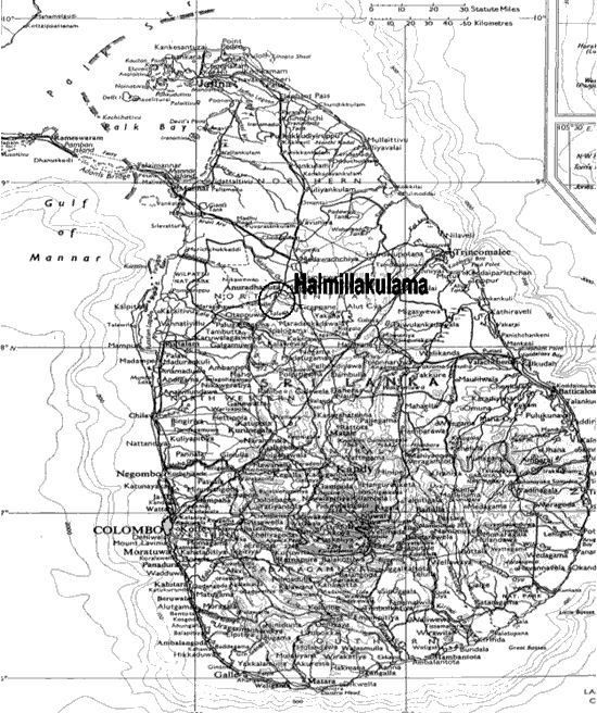
LOCATION
Province: North Central
District: Anuradhapura
Latitude (degrees and minutes): 8°28'N
Longitude (degrees and minutes): 80°44'E
Altitude (m above sea level): 105
Managing office/institution: Forest Department
Owner: do
User(s): do
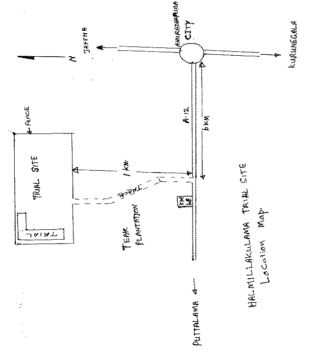
Distance to nearest office responsible for management of the trial (km): 0.6
Distance to nearest villages/towns (km): 1.5
Number of inhabitants in the nearest villages/towns: about 800
Type of area (e.g. research station, managed forest, etc.): Abandoned Chena land adjacent to forest department teak plantation
CLIMATE
Nearest weather station:
Name of the station: Anuradhapura
Latitude (degrees and minutes): 8°29'N
Longitude (degrees and minutes): 80°48'E
Altitude (m a.s.l.): 91
Climatic data1 |
Jan. |
Feb. |
Mar. |
Apr. |
May |
June |
July |
Aug. |
Sep. |
Oct. |
Nov. |
Dec. |
Year |
Rainfall (mm) |
1329 | ||||||||||||
Temp. mean (_C) |
27.1 | ||||||||||||
Temp. mean max.2 (_C) |
|||||||||||||
Temp. mean min.3 (_C) |
|||||||||||||
Evapotranspiration4 (mm) |
1 Period of observations:....50.....(specify years) 2 Average of daily maximum temperatures
3 Average of daily minimum temperatures 4 Potential evapotranspiration (ETP) - Penman's formula
Rainy season:
Number/type of seasons: |
x |
one |
two |
even/irregular |
Period(s): November - December - January (specify months)
Length of rainy season:
No. of intermediate days: 40-50 (pre- and posthumid period of the growing season)
No. of wet days: 80-90 (growing season)
Number of dry months per year (< 50 mm rain/month): 6
Frost (number of days/year): None
Prevailing winds (direction, period, speed):
TOPOGRAPHY (slope) of trial site
x |
Flat/gentle (0-8%) |
Intermediate (9-30%) |
Steep (>30%) |
GENERAL SOIL DESCRIPTION |
Soil texture |
Soil depth |
Soil drainage/ Waterlogging |
Gravel content, topsoil | ||||
1. Light/sandy |
1. Shallow (< 50 cm) |
1. Well drained |
x |
1. None (< 15 %) |
|||
2. Medium/loamy |
x |
2. Deep (50-100 cm) |
2. Seasonal |
2. Gravelly (15-35 %) |
x | ||
3. Heavy/clayey |
3. Very deep (> 100 cm) |
x |
3. Permanent |
3. Stony (> 35 %) |
|||
Organic matter content |
Reaction (pH) |
Soil salinity |
Groundwater | ||||
1. Poor (< 2 % DM) |
1. Acid (pH < 6.5) |
1. None |
1. Shallow (< 50 cm) |
||||
2. Medium (2-5 % DM) |
x |
2. Neutral (6.5-7.5) |
x |
2. Moderate |
x |
2. Deep (50 - 150 cm) |
|
3. Rich (> 5 %) |
3. Alkaline (pH> 7.5) |
3. High |
3. Very deep (>150 cm) |
x | |||
Specify soil unit, soil association and phases (subdivisions of soil units) according to the Soil map of the world (FAO-Unesco 1971-1979), if known:
VEGETATION
Natural (original) vegetation type: Dry,mixed evergreen forest disturbed by shifting cultivation
Dominant natural (original) genera/species: Diospyros manilkara chloroxylon
Land use history: Natural forest cleared for shifting cultivation and abandoned for about 15 years. Secondary scrub forest growth burned and cleared for plantation establishment
Apparent major problems of site (pests, diseases, etc):.Moisture is a limiting factor for tree growth. Rainy season is very short. Elephants and cattle grazing can give problems.
Economic data, viz. farm gate prices for fodder, fuel wood, small size timber, extractives, and other minor produce: N.A.
TRIAL ESTABLISHMENT AND MANAGEMENT
Year and month of establishment: 11/1997
Area (ha): 0.25 ha
Initial spacing (m x m): 2.5 x 2.5 m
Soil preparation (time, method/intensity): Site clearing, making holes 30 x 30 x 30 cm filled with
top soil
Planting method(age of seedlings, type): 2 years old rooted stumps
Beating up (time, %): No - none seedlings available for beating
Irrigation (time, amount): No
Fertilization (time, type, amount): No
Weeding (time, intensity): 3 weedings per year
Thinning (time, intensity): No
Firelines: Fire line cleared during the dry season
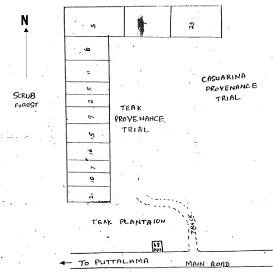
TRIAL DESIGN
Statistical design: Since there were insufficient seedlings for a replicated trial, planted as provenance
blocks
No. of replications (blocks): 1
No. of treatments (provenances): 13
Plot size (No. of trees in plot):Vary with provenance from 12 to 30 trees
Demarcation (blocks, plots): Blocks
PROVENANCES TESTED
Marked provenances have been included in the trial:
Nazir Hat (01/BGD/Naz) |
Annur (06/IND/Ann) |
Vientiane (11/LAO/Vie) |
Tibbi Laran (16/PAK/Tib) |
Ban Bo (21/THA/Bo) |
Chapai Nawabganj (02/BGD/Cha) |
Ghaati Subramanya (07/IND/Gha) |
Yezin (12/MYA/Yez) |
Multan (17/PAK/Mul) |
Doi Tao (22/THA/Doi) |
Mandore (03/IND/Man) |
Sagar Chanatoria (08/IND/Sag) |
Myene (13/MYA/Mye) |
Kuliyapitiya (18/SRL/Kul) |
Sunyani (23/GHA/Sun) |
Chitradurga (04/IND/Chi) |
Balharshah (09/IND/Bal) |
Lamahi (14/NEP/Lam) |
Tung Luang (19/THA/Thu) |
Bandia (24/SEN/Ban) |
Allahabad (05/IND/All) |
Ramannaguda (10/IND/Ram) |
Geta (15/NEP/Get) |
Ban Nong Rong 1 (20/THA/Non) |
Chamwino (25/TAN/Cha) |
Names of any local provenances included in the trial:
PROTECTION STATUS:
Status (describe any disturbances/damages): Herds of grazing cattle present in the site.
Wild elephants periodically visit the site for grazing.
Guarding (permanent, regular, none): Barbed wire fence erected around the site. But this does not
keep the cattle out from the site. A watcher is also employed to guard the site
Location map - Halmillakulama, Sri Lanka
Legend:
Local No.: |
International No.: |
Local No.: |
International No.: |
Local No.: |
International No.: |
1 |
25/TAN/Cha |
7 |
10/IND/Ram |
16 |
06/IND/Ann |
2 |
11/LAO/Vie |
9 |
13/MYA/Mye |
21 |
14/NEP/Lam |
3 |
21/THA/Bo |
10 |
23/GHA/Sun |
23 |
18/SRL/Kul |
5 |
20/THA/Non |
11 |
09/IND/Bal |
||
6 |
22/THA/Doi |
15 |
08/IND/Sag |
Another international Neem provenance trial was established in Sri Lanka in 1996 at Nakele, but this trial was completely destroyed by drought following establishment.
![]()
![]()
![]()