


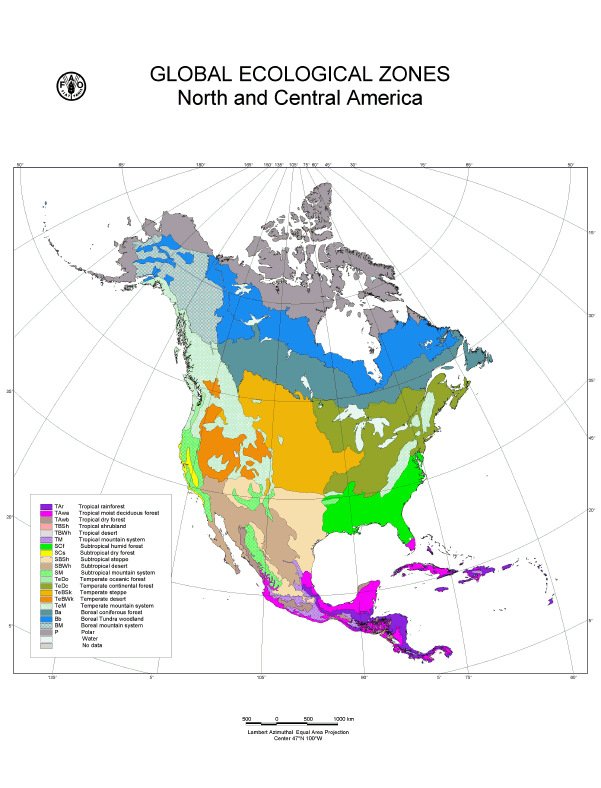
Figure 33. GEZ map of North and Central America.
Table 18. Global Ecological Zones of North and Central America.
Surface area | |||
Km2 |
% of total land area Region |
% of GEZ worldtotal | |
Tropical rain forest |
440 880 |
2.0 |
3.0 |
Tropical moist deciduous forest |
678 048 |
3.1 |
6.1 |
Tropical dry forest |
226 004 |
1.0 |
3.0 |
Tropical shrubland |
2 147 |
0.1 |
0.0 |
Tropical desert |
0 |
0 |
0 |
Tropical mountain systems |
259 112 |
1.2 |
5.7 |
Subtropical humid forest |
1 068 503 |
4.9 |
22.8 |
Subtropical dry forest |
87 039 |
0.4 |
5.5 |
Subtropical steppe |
1 167 280 |
5.4 |
23.8 |
Subtropical desert |
1 083 874 |
5.0 |
16.3 |
Subtropical mountain systems |
592 297 |
2.7 |
12.2 |
Temperate oceanic forest |
40 123 |
0.2 |
2.2 |
Temperate continental forest |
2 023 770 |
9.3 |
29.1 |
Temperate steppe |
2 121 768 |
9.8 |
36.0 |
Temperate desert |
742 929 |
3.4 |
13.8 |
Temperate mountain systems |
1 976 781 |
9.1 |
27.4 |
Boreal coniferous forest |
2 186 972 |
10.0 |
25.8 |
Boreal tundra woodland |
2 566 393 |
11.8 |
65.0 |
Boreal mountain systems |
1 182 345 |
5.5 |
18.8 |
Polar |
3 220 372 |
14.9 |
60.0 |
Total land area |
21 666 637 |
99.8 |
|
The polar domain of North America occupies northern Alaska, northern Yukon, the Arctic islands of Canada, northern Labrador, portions of the Northwest Territories and northern Quebec.
Climate
This Ecological Zone experiences long, cold winters and short, cool summers. The climate is most extreme in the Arctic Cordillera. Mean annual temperature ranges from around 20oC in the most northern part to -7oC in the south; summer mean temperatures range from 6o to +6 oC; winter mean temperatures from as low as 35oC in the mountains of Ellesmere Island to -17.5oC in northern Quebec. The annual precipitation varies from 100 mm to 600 mm. Snow may fall any month of the year and usually persists on the ground for at least 10 months (September to June). Permafrost is continuous and may extend to a depth of several hundred meters.
Physiography
Two rather distinct regions may be distinguished: the Arctic Cordillera, occupying the northeastern fringes of the continent and the large tundra region. The former is a vast mountain chain of deeply dissected Precambrian crystalline rocks. Elevations range from sea level to over 2000 m above sea level. Massive ice caps and valley glaciers mask many of the rugged mountains. Most of the rugged landscape is ice or exposed bedrock. The tundra region consists largely of broadly rolling uplands and lowlands, mostly underlain by Precambrian granite bedrock with some areas of flat-lying Paleozoic and Mesozoic sedimentary bedrock. The undulating landscape is studded with innumerable lakes and wetlands. Soils are frozen, with a shallow and wet layer in summer.
Vegetation
In the most northern fringes of the zone, vegetation only grows in sheltered valleys and along coastal margins and consists of herbaceous and shrub-type communities. Further south, the tundra vegetation is dominated by dwarf shrubs. Major river valleys support scattered clumps of stunted spruce trees. Typical shrubs include dwarf birch (Betula spp.), willows (Salix spp.) and heath species commonly mixed with various herbs and lichens. Wetlands are common in the low-lying areas, mainly supporting sedge and moss covers.
Climate
Climate is characterized by short, cool summers and long, cold winters. Cold arctic air influences the zone for most of the year. Mean annual temperature ranges between -10oC in the Mackenzie Delta to 0oC in parts of Labrador. From north to south, the mean summer temperature varies from 6o to 14oC. The mean winter temperature ranges between 26o and -16oC. Snow and freshwater ice persist for six to eight months of the year. The mean annual precipitation is low in the west ranging 200-500 mm. Higher mean levels are reached in the east where the average varies between 500-800 mm and portions of Labrador reaching 1000 mm.
Physiography
This Ecological Zone is segmented by a huge lowland plain, the Hudson Plain. This region is underlain by flat-lying Paleozoic and Proterozoic sedimentary rock. Elevations rarely exceed 500 m above sea level. Extensive wetlands with subdued glacial features and a belt of raised sandy beach strands characterize the surface. Coastal marshes and tidal flats are extensive along the shores of Hudson Bay and James Bay within this zone. The relief of this lowland has been significantly affected by post-glacial marine submergence and rebounding of its surface. Due to poor drainage, organic cryosolic and mesisolic soils predominate. Regosals are common along the coast. Permafrost is continuous in the north and patchy in the south.
The western portion of this zone consists of subdued broad lowlands and plateaus incised by major rivers. It is largely underlain by limestone, shale and sandstone. Surface deposits are largely glacial till with areas of lacustrine. Alluvium is common within the river valleys. A large portion of the area is underlain by permafrost. Patterned ground features are common.
Vegetation
The Hudson Bay lowlands of this Ecological Zone contain the largest extensive area of wetlands in the world. Vegetation associations consist of arctic tundra and some boreal forest transition types. The poorly drained areas support dense sedge-moss-lichen covers and the better-drained sites support open woodlands of black spruce (Picea mariana), tamarack (Larix laricina) and some white spruce (P. glauca). The raised beaches present a striking pattern of successive black spruce ridges alternating with bogs and fens. The predominant shrub layer consists of dwarf birches, willows and Labrador tea (Ledum groenlandicum). Balsam poplar (Populus balsamea), white spruce and white - or paper birch (Betula papyrifera) are common along rivers.
East of the Hudson Bay lowlands, there are large tracts of open stands of black spruce woodland with an understorey of lichen and feather moss. Generally, much of the wind-swept plateau lands is dominated by open stands of stunted black spruce and tamarack with Labrador tea and sphagnum moss. White spruce is also present. There are large areas of treeless bogs and fens except for dwarf black spruce and tamarack. Alder (Alnus incana) thickets are common along river banks and other drainage areas. Other species occurring sporadically include trembling or quaking aspen (Populus tremuloides) and balsam fir (Abies balsamea). Limited treed vegetation occurs along the exposed headlands of the Atlantic Coast and within the interior most wind-swept barrens.
In the central portion of this zone, west of Hudson Bay, open stands of black and white spruce and tamarack dominate. Sometimes these open forests comprise jack pine (Pinus banksiana) as well. Low shrub tundra-like vegetation is common, characterized by willow and birch shrubs. Bare rock outcrops and wetlands are also common.
The western limits of this Ecological Zone are characterized by open, generally slow-growing, black spruce. Upland and foothill areas and southerly locales tend to be better drained and are warmer than that typical for the zone. In these areas, mixed wood forests characterized by white and black spruce, lodgepole pine (Pinus contorta), tamarack, white birch, trembling aspen and balsam poplar are common. Along nutrient-rich alluvial flats, white spruce and balsam poplar grow to sizes comparable to the largest in the boreal forest to the south.
Climate
Climate is generally continental with long, cold winters and short, warm summers. Continental effects of climate are modified in the east with proximity to the Atlantic Ocean. The mean annual temperature ranges between -4oC in central Canada to 5.5oC in the boreal regions of the Island of Newfoundland. Mean summer temperatures vary between 11o and 15oC with mean winter temperatures occurring between -20.5o C in the west to -1oC in the east. Mean annual precipitation varies between 100 and 625 mm with the exception of boreal Newfoundland where precipitation averages are higher, being in the range of 900 - 1600 mm.
Physiography
A broadly rolling mosaic of uplands and associated wetlands dominates this Ecological Zone. Except in the west, Precambrian granitic rock outcrops are interspersed with ridged to hummocky deposits of glacial till, fluvioglacial materials (including numerous eskers) and colluvium. Soils are acidic and range from humo-ferric podzols in the south to brunisols in the north. Luvisols have limited distribution where silts and clays dominate. Peatlands with organic soils are common. In the west, cretaceous shales dominate. The topography is generally gently rolling consisting of hummocky to kettled glacial deposits and lacustrine deposits. Surface materials are generally deep with luvisols and brunisols being the dominant soils. Permafrost is frequent within the peatlands.
Vegetation
Much of the Ecological Zone is distinguished by closed stands of conifers, largely white (Picea glauca) and black spruce (P. mariana), balsam fir (Abies balsamea) and tamarack (Larix laricina). Common deciduous species include white birch (Populus papyrifera), trembling aspen (P. tremuloides) and balsam poplar (P. balsamea). In the southern boreal, conifers such as eastern white (Pinus strobus), red (P. resinosa) and jack pine (P. banksiana) are evident. At the transition with southern forests, species such as sugar maple (Acer saccharum), black ash (Fraxinus nigra) and eastern white cedar (Thuja occidentalis) are found.
To the western boundary of the boreal, lodgepole pine (Pinus contorta) begins to make an appearance. In general the vegetation is medium to tall, closed stands of trembling aspen, balsam poplar and jack pine with white and black spruce occurring in late successional stages. Lodgepole pine may dominate in some of the upland areas along with white spruce and balsam fir. The poorly drained valleys tend to be concentrated with black spruce. The western boreal transition to the south is often characterized by trembling aspen and balsam poplar. White spruce and balsam fir are the climax species but are not widespread due the frequent occurrence of fire. Poorly drained bogs and fens are characterized by tamarack, black spruce, several ericaceous shrubs and mosses.
The eastern boreal forest is characterized by both open and closed black spruce and balsam fir forests with a ground cover of mosses and ericaceous shrubs. White birch and trembling aspen are typical of disturbed sites. White spruce is generally more tolerant of ocean spray and is thus more prevalent than black spruce or tamarack in areas exposed to the ocean. Kalmia (Kalmia angustifolia, K. latifolia) are very common shrubs. Wetlands are extensive and are comprised by a cover of stunted black spruce, tamarack or shrubs such as kalmia or Labrador tea (Ledum groenlandicum).
The northern boreal Ecological Zone is transitional to the boreal tundra. Drier sites are characterized by pure stands of jack pine or mixed stands of jack pine, white birch and trembling aspen. Wet sites are dominated by black spruce and balsam fir. Treed fens and bogs are dominated, as well, by stunted black spruce and tamarack.
Precambrian granitic bedrock dominates the central and eastern portions of the zone. This is overlain by coarse till deposits interspersed with marine and lacustrine deposits. Long, sinuous esker formations are common. Thousands of lakes and wetlands dot the landscape and lowlands are often covered with peatlands. Permafrost is discontinuous but widespread. Brunisolic and humo-ferric podzolic soils are dominant in the south. Cryosols are widespread in northern regions and, within wetlands, gleysols and organic croyosols are present.
Climate
The climate ranges from cold, subhumid to semiarid. It is marked by long, cold winters and short, warm summers. Mean annual temperatures range from 10o in the north to 5oC in the south. Mean summer ranges are 6.5o to 11.5oC and mean winter temperatures range between 13o and 25oC. Mean annual precipitation is lowest in valleys in the rain shadow of the Coast Ranges (less than 300 mm) and increases in the interior ranges where up to 1500 mm of precipitation is received at higher elevations.
Physiography
This Ecological Zone is characterized by mountain ranges that contain numerous high peaks and extensive plateaus which are separated by wide valleys and lowlands. Bedrock is largely sedimentary and igneous. Surface features have been modified because of glaciation, erosion, solifluction and aeolian and volcanic deposition. A small portion of the northwest was unglaciated. Permafrost is widespread. Cryosols dominate with warmer, lower elevations having brunisols, podzols and luvisols. Abundant permafrost features such as peat hummocks, palsas and peat plateaus are common.
Vegetation
To the north, natural vegetation ranges from arctic and alpine tundra associations of dwarf shrubs, mosses and lichen at higher elevations to open woodland of white spruce (Picea glauca) and white birch (Betula papyrifera) mixed with dwarf birches and willows. The unglaciated Old Crow Basin comprises stunted stands of black spruce and tamarack with some white spruce. Wetlands are common as well.
To the south, there are grasslands on south-facing slopes with boreal vegetation on north-facing slopes. In general, vegetative cover ranges from closed to open forest over much of the plateaus and valleys. White and black spruce, subalpine fir (Abies lasiocarpa), lodgepole pine (Pinus contorta), trembling aspen (Populus tremuloides), balsam poplar (P. balsamea) and white birch occur. Lodgepole pine and subalpine fir tend to disappear rapidly northwards. At higher elevations, extensive areas of rolling alpine tundra characterized by sedge meadows and rock are predominant.
Climate
The nearness of the Pacific Ocean profoundly moderates the climate and annual temperatures averages 9o to 13oC. The moderate rainfall reaches its maximum in winter; summer has a slight moisture deficit. Average rainfall ranges from around 400 to 1500 mm, but in much of the area, the range is from 750 to 1150 mm. Coastal mountains are responsible for the drier and less muted climate. Fog partially compensates for the summer drought.
Physiography
This relatively small Ecological Zone occupies a north-south depression between the Pacific Coast range and the Cascade Mountains. Elevation ranges from sea level to around 500 meters. Landform is characterized by level to gently sloping floodplains bordered by dissected high terraces and hills. Isolated hills and low mountains do also occur. The predominant soils are solenetz, brunisols and podzols.
Vegetation
Before cultivation, dense coniferous forest dominated the vegetation. The temperate coastal forests are composed of mixtures of western red cedar (Thuja plicata), western hemlock (Tsuga heterophylla) and Douglas-fir (Pseudotsuga menziesii). In interior valleys of Washington and Oregon, the coniferous forest is less dense than along the coast and often contains deciduous trees, such as big-leaf maple (Acer macrophyllum), Oregon ash (Fraxinus latifolia) to the south and black cottonwood (Populus trichocarpa). There are woodlands that support open stands of oaks or are broken by groves of Douglas fir and other trees; principal indicator species are Garry or Oregon white oak (Quercus garryana) and Arbutus or Pacific madrone (Arbutus menziesii). Poorly drained sites with swamp or bog communities are abundant.
Climate
Much of the continental portion of this Ecological Zone is marked by warm summers and cool winters. The weather is highly changeable as the Zone falls along one of the major storm tracks of North America. Mean annual temperatures range from 2o to 10o C. The mean summer temperature ranges from 16o to 18o C with mean winter temperatures ranging from -2.5o to 7o C. Mean annual precipitation over much of the Ecological Zone ranges 720-1000 mm.
The proximity of the Atlantic Ocean moderates the climate of eastern portion of this Ecological Zone. It creates a cool, moist, maritime climate and moderate temperatures occur. Mean annual temperatures range from 3.5o to 6.5o C. Annual summer means fall between 13o and 15.5o C. Mean winter temperatures are spread between -8o to -2o C, the warmer temperatures occurring along the Atlantic Coast. Mean annual precipitation varies from 900 to over 1500 mm near the coast.
Physiography
The interior of the Ecological Zone is underlain by carbonate-rich Paleozoic bedrock. Topography is a combination of level plains and gently rolling hills consisting of deep morainal, lacustrine and marine/estuarine deposits. Fine-textured luvisols, along with more coarse-textured brunisols and poorly drained gleysols are the predominant soils. Along the northern fringe, adjoining the Boreal Ecological Zones, podzols and brunisols are prevalent on coarse textured soils. The Zone contains the most productive agricultural soils in Canada.
The lower parts of the Appalachian Uplands and the Northumberland Coastal Plains comprise the eastern portion of the unit. The uplands are composed of granite, gneiss and other hard crystalline rocks. This upland terrain is covered by glacial till and coarse-textured humo-ferric podzols are the dominant soils. In the coastal lowland areas, deeper, more fertile luvisolic soils exist. These fine to moderate textured soils are underlain by sedimentary bedrock.
Vegetation
At one time the entire Ecological Zone was heavily forested, supporting more species of trees than any other part of Canada. However, most of the forests of the area around the Great Lakes and the northeastern United States have succumbed to urbanization and conversion to agricultural activity. Where forest cover exists, it varies from the mixed-coniferous/deciduous stands of white and red pine (Pinus strobus, P. resinosa), eastern hemlock (Tsuga canadensis), red oak (Quercus rubra), sugar maple (Acer saccharum) and white birch (Betula papyrifera) in the northern portions to the rich diversity of the deciduous Carolinian forest and in the southwest.
Historically, the Great Lakes Lowlands and large parts of the North-eastern United States were covered by deciduous forest, dominated by tall broadleaf trees that provide a dense, continuous canopy in summer and shed leaves completely in winter. Lower layers of small trees and shrubs develop weakly. In spring, a luxuriant cover of herbs quickly develops, but is greatly reduced after trees reach full foliage and shade the ground. The mixed mesophytic association, the deciduous forest with the greatest diversity, occupies well-drained sites. Widespread dominants include sugar maple, American beech (Fagus grandifolia), white elm (Ulmus americana), basswood (Tilia americana), red and white oak (Quercus rubra, Q. alba), walnut (Juglans nigra, J. cinerea), hickory (Carya ovata, C. cordiformis), buckeye (Aesculus spp.) and eastern hemlock (Tsuga canadensis), in addition to 20-25 other species. Some of the rarest trees in Canada, such as the sassafras (Sassafras albidum), tulip tree (Liriodendron tulipifera), sycamore (Platanus occidentalis) and cucumber-tree (Magnolia acuminata), were native to the southern part of this Zone. An oak association, with white oak and northern red oak as dominant species, occurs east of the Appalachian Mountains. American chestnut (Castanea dentata) formerly was abundant, but a blight has destroyed much of this species.
Further inland, where precipitation is lower, the drought resistant oak-hickory association is the dominant vegetation, which has both species in abundance. The oak-hickory forest is medium-tall to tall, becoming savannah-like in its western reaches, where it gradually turns into prairie. It sometimes forms a mosaic pattern with prairie. Widespread dominants are white oak, red oak, black oak (Quercus velutina), bitternut hickory (Carya cordiformis) and shagbark hickory (Carya ovata). The understorey is usually well developed, often with flowering dogwood. The shrub layer is distinct, with some evergreens. Many wildflower species occur. Wetter sites typically feature an abundance of American or white elm, tuliptree (Liriodendron tulipifera) and sweetgum (Liquidambar styraciflua). Northern reaches of this association contain increasing numbers of maple, beech and basswood (Tilia americana).
Much more forest exists in the northeastern portion of this Ecological Zone. Here, forests are generally composed of mixed stands of conifers and deciduous species characterized by red spruce (Picea rubens), balsam fir (Abies balsamea), yellow birch (Betula alleghaniensis) and sugar maple. Red and white pine and eastern hemlock occur to a lesser but significant degree. Some boreal species are present, including black (Picea mariana) and white spruce (P. glauca) balsam poplar (Populus balsamifera) and white birch. Jack pine (Pinus banksiana) is prominent on sandy soils. A pine-oak forest occupies dry sandy soils along the northern Coastal Plain of the US that are frequently exposed to naturally occurring fires. There is a thick shrub layer beneath the pines. Eastern white cedar (Thuja occidentalis) occur on mesic sites.
Climate
The climate of this North American Ecological Zone is greatly influenced by its location in the heart of the continent. The Rocky Mountains to the West impede easy access of moisture-bearing winds from the Pacific Ocean. This results in the Ecological Zone having a continental climate that is subhumid to semiarid with short, hot summers and long, cold winters. Generally, the zone is characterized by low precipitation and high evaporation. Mean annual temperatures range from 1.5o to 3.5oC. Mean winter temperatures range from -12.5o to -8o C and mean summer temperatures from 14o to 16oC.
Mean annual precipitation is variable covering a range between 250 mm in the arid grasslands to near 700 mm in the higher elevation wooded portions (elevations that reach to 200 m above surrounding plains). Much of the Zone receives around 300-400 mm of rain annually and a water deficit situation is characteristic of this Ecological Zone.
Physiography
Cretaceous shales and flat-lying Paleozoic limestone underlie the Zone. The surface is a nearly level or rolling plain consisting of hummocky glacial, calcareous moraine or gently undulating lacustrine deposits. Scattered glaciofluvial deposits occur. The inherent soils are Black, Dark Gray and Dark Brown Chernozems. These soils have a high moisture-holding capacity and are naturally fertile, both characteristics conducive to agricultural production. The southern portions of the Zone have large areas of Solonetzic soils. The upper elevation forested soils are dominated by luvisols. Depending on rainfall, there are millions of small wetlands in the form of sloughs, ponds and marshes.
Vegetation
Aspen parkland constitutes the northern edge of this Ecological Zone, a transition zone to the boreal forest to the North. It is associated with groves of trembling aspen (Populus tremuloides), balsam poplar (P. balsamifera) and intermittent grasslands. The aspen parkland has expanded southward considerably since the prairie fires were effectively stopped by settlement. Much of the Zone however, was historically natural steppe grassland dominated by spear grass (Poa annua), wheat grass (Agropyron spp.) and blue grama grass (Bouteloua spp.). Sagebrush (Artemisia tridentata) was and remains abundant. Yellow cactus and prickly pear (Opuntia spp.) are found on dry sites. Along with the encroachment of aspen, agricultural activity has substantially reduced the area of natural grassland. Today, native vegetation is relegated to non-arable pasture lands dominated by spear grass and wheat grass and a variety of shrubs. Patches of scrubby aspen (Populus), willow (Salix), cottonwood (Populus) and box-elder (Acer negundo) occur on shaded slopes of valleys and river terraces. To the East, the Zone consists of a mosaic of trembling aspen, bur oak (Quercus macrocarpa) and grasslands (e.g. Andropogen gerardii, Panicum virgatum, Sorghastrum nutans). Further south, oak and hickory become the dominant tree species in the prairie-parkland transition zone with the eastern broadleaf forests.
Climate
The aridity of this Ecological Zone is the result of the rain shadow of the Sierra Nevada and Cascade Mountains ranges as they intercept the wet winter air masses brought by the westerly and easterly winds. Summers are hot and winters are cold, with stronger seasonal temperature extremes on the higher plateaus. The average annual temperature ranges from 4o to 13oC. Spring comes early, except at higher elevations. Annual precipitation averages about 130 to 400 mm. Almost no rain falls during the summer months. Part of the winter precipitation falls as snow.
Physiography
The zone covers the physiographic region called the Great Basin, the northern Colorado Plateau in Utah and the plains and tablelands of the Columbia-Snake River Plateaus and Wyoming Basin. Much of the southern part of this zone is made up of separate interior basins; only a small part of it drains to the sea. The lower parts of many basins have heavy accumulations of alkaline and saline salts. The northern plateaus include most of the Northwests lava fields. Lying at about 900 m, the plateaus are surrounded by lavas that have been folded or faulted into ridges. Aridisols dominate all basin and lowland areas, while extensive alluvial deposits, Entisols, are found in stream floodplains and in fans at the foot of mountains. In the southern part of this Ecological Zone, salt flats and playas without soils are extensive in the lower parts of basins with interior drainage.
Vegetation
The chief vegetation, sometimes called sagebrush steppe, is made up of sagebrush (Artemisia tridentata) mixed with short grasses. Other important plants are antelope bitterbrush (Purshia tridentata), shadscale (Atriplex confertifolia), fourwing saltbush (Atriplex sp.), rubber rabbitbrush (Chrysothamnus nauseosus), spiny hopsage (Grayia spinosa), horsebrush (Tetradymia spp.) and short-statured Gambel oak (Quercus gambelii). All these shrubs tolerate alkali to varying degrees, essential to their survival on poorly drained soils. Moist alkaline flats support alkali-tolerant greasewood (Sarcobatus vermiculatus). Along streams in and near the mountains where the water is good, valley bottoms are lined with willows and sedges. Above the sagebrush belt lies a woodland zone dominated by pinyon pine (Pinus edulis) and juniper (Juniperus spp.).
Climate
The climate of this Ecological Zone is extremely varied. Along the Pacific Coast, it ranges from a relatively humid maritime climate at low elevations to cold, arctic conditions above tree line. Along the coast the mean annual temperature ranges from 4.5oC in the north to 9oC in the south. Summer means vary between 10o and 15.5oC with winter means between -0.5o and 3.5oC. Average annual precipitation is extremely variable being 600 mm in the Gulf Islands and ranging up to 4000 mm to the north.
The interior portion of the zone is as variable. The Coastal Ranges and Rocky Mountains create rain shadow areas of mean annual precipitation of 250- 400 mm. This rises to 1500 mm in the mountains. Temperatures in the dry lowlands average 7.5oC annually with a summer mean of 16.5oC and winter mean of -1.5oC. Winter means can reach 15oC and colder with increasing elevation reaching to the ice fields beyond tree line.
The climate of the Appalachian Highlands is temperate, with distinct summer and winter and all areas are subject to frost. Average annual temperatures range from below 10oC in the north to about 18oC at the south end of the highlands. Average annual precipitation varies from 900 mm in the valleys to 2000 mm on the highest peaks, the highest in the eastern United States. A considerable amount falls as snow.
Physiography
This Ecological Zone includes the Coast Mountains, the Rocky Mountains with the highest peaks reaching 3600 m above sea level and the Appalachian Mountains reaching to around 2000 m. Amongst the mountain ranges there are interior plains along with the major intervening valleys. The plains are most extensive in the north. Most of these plains are covered by glacial moraine and some lacustrine and fluvial deposits. Mountains are largely colluvium and rock outcrops. Luvisols and brunisols are the common soils of the interior plateaus and lower slopes. In the wetter mountainous areas, humo-ferric and ferro-humic podzols dominate. Soils of the dry lower valley floors are characterized by chernozems supporting grasslands. The highest elevations consist of alpine glaciers and rock.
Vegetation
This mountainous unit is extremely diverse in terms of major vegetation associations: coastal western hemlock, coastal Douglas-fir, mountain hemlock, interior Douglas-fir, interior cedar-hemlock, montane spruce, englemann spruce-subalpine fir, sub-boreal pine-spruce, sub-boreal spruce, ponderosa pine, bunchgrass and alpine.
The Pacific Coast Mountains comprise the temperate rain forests of the coastal western hemlock zone. These forests are among the most productive in North America and contain some of the worlds largest and long-lived trees. This vegetation association exists at low elevations along the coast and is dominated by western hemlock (Tsuga heterophylla) and amabilis or Pacific silver fir (Abies amabilis) as climax species although several other species are common. Big-leaf maple (Acer macrophylum) reaches its northern extension in the southern portion of this zone. It is generally found along creek beds and other alluvial areas along with red alder (Alnus rubra) and black cottonwood (Populus trichocarpa).
At high elevations, up to 2000 m, mountain hemlock (Tsuga mertensiana), subalpine fir (Abies lasiocarpa) and amabilis fir assume prominence along with yellow or Pacific cedar (Chamaecyparis nootkatensis). Closed stands become open and stunted with higher elevations as sedge and heather communities begin to dominate. Alpine conditions are too severe for the growth of most woody plants except for some dwarf shrubs (Salix spp., Betula spp.) herbs, mosses and lichens.
Amabilis fir, lodgepole pine (Pinus contorta) and sitka spruce (Picea sitchensis) are common in the north. At lower northern elevations, western hemlock and western red cedar (Thuja plicata), dominate with red alder pioneering on disturbed sites. The coastal Douglas-fir association is found in the lee of the coastal mountains. Douglas-fir (Pseudotsuga menziesii) dominates. Western red cedar (Thuja plicata) is typical on wetter sites and Garry oak (Quercus garryana) and arbutus (Arbutus menzeisii) are abundant on drier sites. Salal (Gaultheria shallon) and Oregon grape (Mahonia repens) are common understorey vegetation.
In the rain shadow of the Coast and other mountain ranges of this Ecological Zone, the interior Douglas-fir associations dominate. Fires have resulted in even-aged lodgepole pine stands at higher elevations while ponderosa pine (Pinus ponderosa) is the common seral tree at lower elevations. The very driest portions are dominated by bunchgrasses. The driest associations are the bunchgrass zone which is confined to lower elevations of the hottest valleys. Bluebunch wheatgrass (Elymus spicatum), fescue (Festuca spp.) among others and sage brush (Artemisia tridentata) dominate with some ponderosa pine and Douglas-fir occurring in wet swales. Areas dominated by ponderosa pine represent the warmest and driest forest regions of this diverse Ecological Zone.
The montane spruce association dominates much of the interior plateau regions. Here, at mid elevations, closed stands of englemann spruce (Picea englemanii) and subalpine fir are common. Lodgepole pine, western white pine (Pinus monticola), Douglas-fir and trembling aspen reflect areas of past fire history. At higher elevations the Englemann spruce- subalpine fir begin to dominate. The forest often has an open parkland appearance with trees clumped interspersed with heath and grassland meadows. Under drier conditions extensive lodgepole pine and whitebark pine (Pinus albicaulis) are common. Wetter areas may be dominated by mountain hemlock (Tsuga mertensiana).
The interior wet belt of this Ecological Zone is characterized by a western red-cedar -western hemlock forest. It has the widest variety of conifer trees of all the major forest types within the zone. Along with the two dominant species other common trees include white spruce (Picea glauca), englemann spruce (including hybrids) and subalpine fir. Douglas-fir and lodgepole pine occur in the drier portions of this wet belt. Skunk cabbage (Symplocarpus foetidus) and devils club (Oplopanax horridus) characterize the ground vegetation.
In the sub-boreal plateau areas, south of true boreal forest associations, englemann-white spruce and subalpine fir dominate. Even-aged lodgepole pine and trembling aspen (Populus tremuloides) cover extensive areas of previously burned sites. Wetlands are also extensive and common. An extensive tundra alpine belt occurs at high elevations. Moist meadows with low-lying shrubs, grasses, sedges and mosses are common. At the highest elevations rock and glaciers dominate.
In the Appalachian Highlands, a vertical zonation prevails, with the lower limits of each forest belt rising toward the south. The valleys of the southern parts support a mixed oak-pine. Above this zone lies the Appalachian oak forest, dominated by a dozen species each in the white oak and black oak groups. Above this zone lies the northeastern hardwood forest, composed of birch, American beech (Fagus americana), maple, elm, red oak (Quercus rubra) and basswood (Tilia americana), with an admixture of eastern hemlock (Tsuga canadensis) and white pine. Spruce-fir forest and meadows are found of the highest peaks of the Allegheny and Great Smoky Mountains. Mixed mesophytic forest extends into narrow valleys of the southern Appalachians, where oak vegetation predominates. The northern reaches, composed of the Adirondack and New Highlands, are located in the transition zone between the boreal spruce-fir forest to the north and the deciduous forest to the south. Growth form and species are very similar to those found to the north, but red spruce (Picea rubens) tends to replace white spruce. Here, the valleys contain a hardwood forest, dominated by sugar maple, yellow birch (Betula alleghaniensis) and beech. Low mountain slopes are covered with a mixed forest of spruce, fir, maple, beech and birch. Above the mixed-forest zone lie pure stands of balsam fir (Abies balsamea) and red spruce, which devolve into krummholz at higher elevations. Above the timberline appears alpine meadow.
Climate
Mild winters and hot, humid summers characterize the climate of this Ecological Zone. Average annual temperature is 15o to 21oC. Annual precipitation ranges from around 1000 to 1500 mm and is relatively evenly distributed throughout the year, with most areas having either a summer or spring maximum.
Physiography
This Ecological Zone comprises the Atlantic and Gulf Coastal plains and the piedmont. The flat coastal plains have gentle slopes and local relief of less than 100 m, while the piedmont reaches to about 300 m altitude. Most of the numerous streams in the zone are sluggish; marshes, swamps and lakes are abundant. Ultisols dominate throughout the zone on the higher areas, with Entisols and Inceptisols in alluvial bottomland and floodplains of the major streams. Locally, Vertisols are formed from marls or soft limestones. The soils are derived mainly from coastal plain sediments ranging from heavy clay to gravel, with sandy materials predominant. Silty soils occur mainly on level expenses.
Vegetation
On the coastal plains, temperate rain forest, also called temperate evergreen rain forest or laurel forest, is the dominant natural vegetation. Subtropical rain forest has fewer tree species than its tropical counterpart; trees are not as tall here, leaves are usually smaller and more leathery and the leaf canopy less dense. Common species include evergreen oaks (Quercus myrtifolia, Q. virginiana, Q.laurifolia) and species of laurel and magnolia (Magnolia grandiflora, M. virginiana). There is usually a well-developed lower stratum of lower vegetation that may variously include tree ferns, small palms, shrubs and herbaceous plants.
Further inland, the climax vegetation is medium-tall to tall forests of broadleaf deciduous and needleleaf evergreen trees. Loblolly pine (Pinus taeda), shortleaf pine (P. echinata) and other southern yellow pine species dominate the stands, singly or in combination. Common associates include oak (Quercus spp.), hickory (Carya spp.), sweetgum (Liquidambar styraciflua), blackgum (Nyssa sylvatica), red maple (Acer rubrum) and winged elm (Ulmus alata). The main grasses are bluestem, panicums and longleaf uniola. Dogwood (Cornus spp.), viburnum, hawthorn (Crataegus sp.), blueberry (Vaccinium spp.), American beautyberry (Callicarpa americana), yaupon (Ilex vomitoria) and numerous woody vines are common.
Along the Mississippi river, small patches of riverine deciduous forests still occur, with an abundance of green ash (Fraxinus pennsylvanica), Carolina poplar (Populus deltoides), elm, cottonwood, sugarberry (Celtis laevigata), sweetgum and water tupelo (Nyssa aquatica), as well as oak and baldcypress (Taxodium distichum). Pecan (Carya illinoensis) is also present, associated with American sycamore (Platanus occidentalis), American elm (Ulmus americana) and roughleaf dogwood (Cornus drummondii). Vines are prolific along watercourses. Along the Atlantic coast and Gulf coast, extensive coastal marshes and interior swamps are dominated by gum and cypress.
Today, needleleaf evergreen forests of loblolly and slash pine (Pinus taeda, P. elliottii) are widespread in this Ecological Zone, predominantly as second-growth forest following fire and deforestation.
This Ecological Zone is situated on the Pacific Coast between approximately 30o and 45oN.
Climate
The climate is typically Mediterranean, characterized by hot, dry summers and mild winters, with precipitation associated with winter frontal storms from the Pacific Ocean. Annual temperatures average about 10o to 18oC, with average summer temperature above 18oC and average winter temperatures above 0oC. Annual rainfall ranges from 200 to 1000 mm, depending on latitude and altitude, always with a pronounced summer drought. There is a great annual variability of total precipitation and extreme droughts are not uncommon. Coastal fog is common, particularly from May through July.
Physiography
This zone includes the Pacific Coast, comprising discontinuous coastal plains, low mountains and interior valleys and the Central Valley of California a flat alluvial plain between the Sierra Nevada and the Coast Ranges. The latter area has broad, nearly level valleys bordered by sloping alluvial fans, slightly dissected terraces and the lower foothills of the surrounding uplands. Large undrained basins lie in the south. Elevations range from sea level to 700 1000 m. The soils of this zone include Alfisols, Entisols and Mollisols. They are high in bases and quite fertile when moisture is adequate. In the northern Coastal plains, the dominant soils are Ultisols (under forest).
Vegetation
A number of distinct vegetation types are present. The redwood (Sequoia sempervirens) is characteristic of the fog belt on seaward slopes of coastal northwestern California. Associated with it are Douglas-fir (Pseudotsuga menziesii) and other conifers such as western hemlock (Tsuga heterophylla) and western redcedar (Thuja plicata). The redwood forest is a hygrophyllic type of warm-temperate forest. Redwoods can attain a height of 100 m, but trunks remain relatively slender. Redwood forests typically have a well-developed understorey, usually dominated by large and colourful Pacific rhododendrons and western azaleas (Rhododendron spp.). Other shrubs, especially salal (Gaultheria shallon) and California huckleberry (Vaccinium ovatum) are usually present. Many ferns and flowering plants grow in the cool shade, such as western sword fern and redwood sorrel. Along the coast in a narrow, patchy belt lies pine-cypress forest. Inland, the southfacing mountain slopes are covered by mixed forest, including tanoak (Lithocarpus densiflorus), live oak (Quercus spp.), madrone (Arbutus menziesii) and Douglas-fir.
The central and southern coastal areas are covered by chaparral, a mostly evergreen shrub vegetation. Several tree species are endemic to this region, including the Monterey cypress (Cypressus macrocarpa), Torrey pine (Pinus torreyana), Monterey pine (P. radiata) and Bishop pine (P. muricata). Chaparral has a thickened, hardened foliage resistant to water loss and forms a cover a closely spaced shrubs 1 to 4 m tall. Common shrubs include chamise (Adenostoma fasciculatum), buckbrush or ceanothus (Ceanothus spp.) and manzanita (Arctostaphylos spp.). Coastal sage scrub, summer-deciduous plants that tolerate more dry conditions than the evergreen chaparral, are found at lower elevations. Patches of live oak (Quercus spp., mostly agrifolia) or valley oak (Quercus lobata) woodland are found on the hills and lower mountains.
A blue oak (Quercus douglasii)-foothill pine (Pinus sabiniana) woodland community forms a ring around the Central Valley of California, which itself once had extensive grasslands and riparian forests.
Most of the coastal plains and interior valleys have been converted to urban use or irrigated agriculture. Citrus, grapes, avocados, nuts (such as almonds and walnuts) and deciduous fruits are grown extensively. Irrigated alluvial soils are also highly productive of vegetable crops.
Climate
The climate of this Ecological Zone is semiarid-subtropical. Summers are long and hot and winters are generally short and mild. Annual temperatures average 14o to 21oC. Annual precipitation varies considerably within this Ecological Zone, from about 250 mm in the drier (mostly western) regions, to about 1000 mm in the northeastern Prairie Parkland region, which forms a transition to the subtropical humid forest. In the southern steppe, precipitation falls mostly during the growing season, while it is more evenly distributed throughout the year in the northern parts. High winds of cyclonic origin are an important climatic factor in this Ecological Zone. It is also subject to periodic, intense droughts and frosts.
Physiography
This Ecological Zone is dominated by flat to rolling plains and plateaus. Sizable portions in the United States are hilly or classified as tablelands with moderate relief, 100 to around 1000 m. The Mexican landscape alternates flat areas and low hills. Surface geology of this Ecological Zone is varied; major portions are aeolian, others are stream deposits and much of the zone is comprised of thin residual sediments. The Mexican portion is underlain by Cenozoic sedimentary rocks with recent continental deposits, mainly n the coast. Soils are commonly Mollisols and Aridisols, containing some humus.
Vegetation
A variety of natural vegetation is found in this zone. Grasslands in which shrubs and trees grow singly or in bunches, typical for the steppe or prairie, are predominant. On the plains of the southern US and Mexico, xerophytic grasses (blue grama and buffalo grass) are the characteristic vegetation. However, in much of these areas, mesquite (Prosopis sp.) grows in open stands of prickly shrubs. Other shrub species include acacia (Acacia sp.), paloverde (Cercidium sp.), silverleaf (Leucophyllum sp.), hackberry (Celtis occidentalis), Texas olive (Cordia boissieri), barreta (Helietta parvifolia), corbagallina and ocotillo. Over much of the plateaus, the characteristic vegetation is also grass, especially prairie three-awn (needlegrass); trees and shrubs occur only in very open stands. Locally, oak and juniper are mixed with grasses and mesquite and on steep rocky slopes these trees may form closed stands. Due to low rainfall they rarely grow higher than 5-7 m. The most characteristic tree is Ashe juniper. On slopes down to the Rio Grande, the ceniza shrub dominates. Live oak (Quercus virginiana) forest is found along the Gulf Coast. A unique semiarid forest consisting of small trees and shrubs occupies the Rio Grande delta. The endangered sabal palm (Sabal palmetto) is native here. In the northeastern part of the Ecological Zone, oak savanna, dominated by post oak (Quercus stellata) and blackjack oak (Quercus marilandica), forms a transition with the more humid subtropical forest zone.
The generally higher Colorado Plateau has a distinct vegetation. Woodland is the most extensive vegetation type, dominated by open stands of two-needle pinyon pine and several species of juniper (Juniperus), often termed pygmy forest. In the lowest areas there are arid grasslands. Xeric shrubs grow among the grasses and sagebrush is dominant over extensive areas. A profusion of annuals and perennials blooms during the summer rainy season. At low elevations in the south of the Plateau, several kinds of cactus and yucca are common. Cottonwoods and other trees grow along some of the permanent streams.
South of the Arizona-New Mexico Mountains in the US are the North-American deserts, extending as far south as the Mezquital and Tehucán Valleys in Mexico.
Climate
This Ecological Zone has a desert and steppe climate: arid to semi-arid, with marked seasonal temperature extremes. Summers are long and hot. Winters are short, but may include brief periods when temperatures fall below zero. The climatic condition in this zone is the result of the rain shadow produced by the Eastern Sierra Madre and the Neovolcanic Ridge. Average annual precipitation ranges from as low as around 50 mm to 500 mm locally. The southern deserts have higher average temperatures and evaporation rates. Some northern areas, such as the Sonoran and Chihuahuan deserts, are dominated by a more episodic summer rainfall pattern.
Physiography
Topography of the North American deserts is characterized by extensive plains, most gently undulating, from which isolated low mountains and buttes rise abruptly. Elevations range from 85m below sea level (Death Valley) to around 1200 m. Basins with no outlets drain into shallow playa lakes that dry up during rainless periods, with alluvial fans and bajadas found at the margin slopes. Extensive sand dunes occur in some areas. Soils are dry, mostly Aridisols and dry Entisols, are generally lacking humus and distinct soil profiles and are high in calcium carbonate. A dominant pedogenic process is salinization, which produces areas of salt crust.
Vegetation
The desert vegetation comprises of sparse, low growing shrubs and grass. There is however local variation, related to altitude, latitude and landform diversity. Creosote bush is common in the Mojave desert, which is also the area of the distinctive Joshua tree (Yucca sp.). The Sonoran desert has greater diversity in its vegetation than the other North American deserts that are dominated by low shrubs. Paloverde-cactus shrub vegetation includes various types of cacti, such as saguaro, cholla (Opuntia cholla) and agave (Agave sp.). Plants of the Chihuahuan desert shrub are often shorter with sparser foliage than similar plants of the other deserts. Yuccas, tarbush (Flourensia cernua) and creosote are dominant shrubs and grasses are intermixed throughout much of the Chihuahuan desert. The bajadas and hills include ocotillo (Fouquieria splendens), Joshua tree, lechuguilla (Agave lechuguilla) and prickly pear (Opuntia polyacantha) and some isolated mountains rise high enough to carry a belt of oak and juniper woodland.
The following mountain ranges comprise the Ecological Zone: southernmost portion of the Cascade Mountains and the Rocky Mountains, Sierra Nevada, the Coast Range and the Western Sierra Madre.
Climate
The climate of this Ecological Zone is extremely diverse, related to latitude, altitude and exposure. The prevailing west winds influence climatic conditions; the east slopes are much drier than the west slopes. Rain falls during winter and the yearly amount increases with elevation, at high altitude mostly as snow.
Physiography
The Coast Range, Sierra Nevada and California Mountains are comprised of a mixture of steeply sloping to precipitous mountains crossed by many valleys wit steep gradients, hills and tablelands. It occupies an area of tectonic instability at the interface of the North American and Pacific tectonic plates and contains a variety of active faults. Altitude ranges from around 600 to more than 4300 m. Much of this region has been glaciated. Soils include ultisols on mountain slopes where air is humid, dry Alfisols at lower elevations and entisols in narrow floodplains and alluvial fans of the valleys.
The southern extent of the Rock Mountains consists mostly of steep foothills and mountains, but includes some deeply dissected high plateaus. Elevations range from 1200 to 3000 m, with some mountain peaks as high as 3900 m.
The western Sierra Madre in Mexico is one of the largest volcanic ranges of the world, being some 1250 km long and ranging from 125 to 300 km wide, with elevations up to 3000 m above sea level. Mountains, canyons and foothills are dominant and the bedrock is of igneous origin. Major ranges include: Sierra Tarahumara, Papasquiaro Tepehuanes, Sombrerete. Predominant drainage is toward the Pacific Ocean. The Conchos River and the inner basin of Nazas-Aguanaval are also important in the hydrological system
Vegetation
Vegetation zones are well marked, generally in altitudinal belts.
In the Sierra Nevada, southern Cascades and northern Coast Range, the following zonation prevails:
The lower slopes, from about 500 to 1200 m, are covered by coniferous and shrub associations. On higher slopes, foothill pine (Pinus sabiniana) and blue oak (Quercus douglasii) dominate, forming typical open or woodland stands. Most of the low hills are covered by close-growing evergreen shrubs, or chaparral, in which buckbrush and manzanita (Arctostaphylos sp.) predominate. Several oaks are common associates. Above this belt, the montane zone is situated between 600 and 1800 m in the Cascades and between 1500 and 2400 m or more in the south. The most important trees are ponderosa pine (Pinus ponderosa), Jeffrey pine (P. jeffreyi), Douglas-fir (Pseudotsuga menziesii), sugar pine (P. lambertiana), white fir (Abies concolor), red fir (A. magnifica) and incense cedar (Calocedrus decurrens); but several other conifers are also present. The spectacular giant sequoia (big tree) (Sequoiadendron giganteum) grows in a few groves on the western slopes. Dense chaparral communities of manzanita, buckbrush (Ceanothus cuneatus) and buckthorn (Ceanothus spp.) may appear after fire, sometimes persisting for years. Within the Sierra rain shadow, on the dry eastern slopes, Jeffry pine replaces ponderosa pine. The subalpine zone begins at 1800 2500 m and extends upslope for about 300 m. Mountain hemlock (Tsuga mertensiana), California red fir (Abies magnifica), lodgepole pine (Pinus contorta), western white pine (P. monticola) and whitebark pine (P. albicaulis) are important. The timberline is at about 2100 m in the north to 3000 m in the south
In the drier California Coastal Range further south, the montane vegetation consists of sclerophyll forest and chaparral, in which trees and shrubs with thick, hard evergreen leaves dominate. Chaparral occupies the greater area, found on southfacing slopes and drier sites, while forest appears on northfacing slopes and wetter sites. The most important evergreen trees are California live oak (Quercus agrifolia), canyon live oak (Q. chrysolepis), interior live oak (Q. wislizeni), tanoak (Lithocarpus densiflorus), California laurel (Umbellularia californica), Pacific madrone (Arbutus menziesii), golden chinkapin (Castanopsis chrysophylla) and Pacific bayberry (Myrica californica). Chaparral includes at least 40 species of evergreen shrubs with varying degrees of dominance and importance. Some are so dense that they practically eliminate understorey vegetation; other types support a highly productive understorey. The most important species are chamise and manzanita. Other common species include Toyon (Heteromeles arbutifolia), California scrub oak (Quercus dumosa), mountain mahogany (Cercocarpus sp.) and many species of ceanothus. At higher elevations and near the ocean, chaparral is often interspersed with coniferous forest. The interior valleys have sagebrush and grassland communities and a riparian forest with many broadleaved species grows along streams.
Vegetation zones in the southern Rocky Mountains resemble those further north (see Temperate Mountain systems), but occur at higher elevations. The foothill zone, reaching as high as 2000 m, is characterized by mixed grasses, chaparral brush, oak-juniper woodland and pinyon-juniper woodland. At about 2000 m, open forests of pondorosa pine are found, although pinyon and juniper occupy southfacing slopes. In Arizona, the pine forests area strongly infused with Mexican species, including Chihuahuan pine (Pinus leiophylla var. chihuahuana) and Apache pine and (Pinus engelmanii). Pine forest is replaced at about 2400 m by Douglas-fir. Aspen (Populus tremuloides) is common in this zone and limber pine (Pinus flexilis) grows in places that are rockier and drier. At about 2700 m, the Douglas-fir zone merges into a belt of Engelmann spruce (Picea engelmanni) and corkbark fir (Abies lasiocarpa var. arizonica). Limber pines and bristlecone pines (Pinus longaeva) grow in the rockier places. The alpine zone starts from around 3400 m.
Vegetation of the Western Sierra Madre in Mexico can be evergreen or deciduous, primarily being composed of conifers and oaks. They grow from 10 to 30 m, sometimes reaching 50 m. This vegetative cover may comprise from one to three tree layers, one or two shrub layers and a herbaceous stratum. A mountain cloud forest occurs in places. This forest community is characterized by about 3000 vascular plant species, 30 percent of which are endemic to Mexico. Mexican beech is a relict in Mexico. There are about 40 species of pine and more than 150 species of oak in Mexicomore than anywhere else in the world.
The Ecological Zone encompasses in Mexico parts of the Gulf Coastal Plain, the lowlands of the Chiapas Sierra Madre and in Central America, lowlands along the Caribbean Atlantic coasts and small areas along the Pacific coast. Parts of the Caribbean Islands are also included in this zone.
Climate
Year-round temperatures are averaging between 20°C and 26°C, with little seasonal variation. The average annual precipitation range is 1500 to 3000 mm and in some areas may attain totals of more than 4000 mm. The number of dry months is less than three and occurs during winter. Hurricanes (Tropical cyclones) are responsible for very heavy regional rains between August and October. They are uncommon or absent south of about 12oS (Costa Rica and Panama).
Physiography
Topographically speaking, there are two distinct units within the tropical rain forest zone. One is the lowland, frequently poorly drained and the other is a very steep area in the lower portions of the central ranges. The lowlands are found in northeast Costa Rica, east of Nicaragua and along the northeast coast of Honduras. Another big portion with these characteristics is located on the Atlantic side of Guatemala, Belize and Mexico. The steep areas are found extensively in Panama and Costa Rica. Other areas include the border region of Nicaragua and Honduras and the northern-exposed middle elevations of Honduras and Guatemala, including the Mayan Mountains. Guatemala has also a section of this type of Ecological Zone in the Pacific southwest region.
Vegetation
The tropical evergreen to semi-evergreen rain forest along the Atlantic coast is a tall and dense forest. There are many species of canopy trees, some being deciduous during the dry season. The forest has a complex and diverse flora and the number of vascular plant species approximates 5000. Canopy trees reach 30 to 40 m high with emergent trees up to 50 m. Trees have round crowns and thick, clean and vigorous stems, some with well-developed buttresses. The subcanopy layer is dense with trees from 5 to 25 m tall, most of them with good-shaped stems and small buttresses. The understorey layers present a great variety of palms and tree ferns. Forest stands are typically of mixed ages with a great abundance of air plants (epiphytes): bromeliads, ferns and orchids among others. Common tree species include: paque or paleto (Dialium guianense), allspice tree (Pimenta dioica), breadnut (Brosimum alicastrum), Manteco (Ampelocera hottlei), Masica (Brosimun alicastrum), Masaquilla (Pseudolmedia cf. spurea), Laurel (Cordia alliodora, C. bicolor) Maria (Callophyllum brasiliense), Hule (Castilla elastica, C. Tunu), Cuajada (Dendropanax arboreus), Caobina (Mauria sessiliflora), Seliyon (Pouteria izabslensis), Sangre de Pozo (Pterocarpus offfcinalis), Varillo (Zymphonia globulifera), Caoba (Swietenia macrophyulla), Cumbillo or sombrerete (Terminalia amazonia), Sangre Real (Virola koschnyi) and San Juan or copai-yé wood (Vochisia hondurensis).
At infertile locations, for instance on top of hills and slopes, pine grows, alone or in association with oak. In addition, there are abundant Guamiles (young secondary forests) in different successional stages, a result of abandoned subsistence agriculture.
The tropical evergreen and semi-evergreen forest in the northern part of the zone (Nicaragua, Honduras, Peten region in Guatemala, Belize) have been historically exploited for mahogany hardwood (Swietenia macrophylla). Gum (Manilkara) and Palo tinte (Haematoxilum) are other important timber species. Also in Mexico, the forests have been widely exploited for precious woods like mahogany and red cedar.
Beside the formations described above, there are also well-developed rain forests in specific places on the Pacific side of Central America, characterized by high biomass levels. There are other forests as tall or taller than this, but the many strata and rapid natural turnover of the forest (probably less that 100 years) make it very special.
In a middle elevation belt approximately between 400 and 1300 m altitude on the wetter (Atlantic) side of the Central America ranges, also known as coffee belt, grows an evergreen forest, intermediate in height, with two or three strata. Canopy trees are mostly 30-40 m tall, with round or umbrella-shaped crowns and straight branches. Buttresses are common but small. The subcanopy is very dense with trees 15-25 m tall, slender trunks often unbranched for most of their length, narrow, round to conical crowns and thin, light or dark-coloured bark. Palms are common at well-drained locations. The understorey is also very dense and may be difficult to distinguish from the subcanopy stratum. Understorey trees are 8-15 m tall, often with leaning, crooked or twisted trunks and relatively long crowns with horizontal branches; many trees have stilt roots. Tree ferns are common in the understorey. The shrub layer is 2-3 m tall and very dense. Dwarf palms are uncommon in the shrub layer. The ground layer consists of a nearly continuous cover of ferns, Selaginella and broadleaved herbs, often with bluish leaves. Epiphytes cover practically all surfaces.
Climate
The climate of this Ecological Zone is drier than in the rain forest zone and the dry season is more pronounced (3 5 months). Along the Pacific coast, the amount of precipitation diminishes from Guatemala to El Salvador and Honduras, where locations at the Fonseca Gulf, together with some of the small closed interior valleys in Guatemala and Honduras, are the driest part of the region. Then, precipitation increases from Nicaragua to Costa Rica decreases again in Panama after the Azuero peninsula. Common average annual precipitation is around 1300 mm in El Salvador. It lowers to less than 1000 mm in Honduras and it increases again from Nicaragua to Costa Rica. Most of the Yucatan Peninsula in Mexico receives 1000 1500 mm annually.
Physiography
The zone comprises the lower Pacific part of the Central ranges in Central America, the plains and hills of the Yucatan Peninsula, humid parts of the Gulf of Mexico plains and the Everglades.
Vegetation
The predominant vegetation is high deciduous forest with three or four storeys and approximately 100 tree species in the associations on fertile soils. The most typical tree species in this formation are Cordia alliodora, Carapa guianensis, Guarea, Vitex, Virola, Calophyllum brasiliensis, Terminalia chriquensis, Dialium guianensis, Tabebuia pentaphylla, Ochroma lagopus and Manilkara. From Nicaragua southwards, the associations are enriched by many South American species such as Anacardium excelsum, Dipteryx panamensis, Eschweilera calyculata, Lecythis and Prioria copaifera.
Certain distinct associations include pure stands of cativo (Prioria copaifera) on riparian flood lands, palm swamps and the mangrove swamps on the tidal estuaries.
On the drier parts of the coffee belt, from 600 to about 1600 m, grows a two-layer semideciduous, seasonal forest of medium height. Canopy trees are mostly dry season deciduous, about 25 m tall, with characteristically broad, flat or umbrella-shaped crowns and relatively short, stout trunks, often with thick, fissured or flaky bark. Compound leaves are very common. Understorey trees are 10-20 m tall, evergreen, with round to conical crowns and short, twisted or crooked boles with smooth or moderately rough bark. There is a dense shrub layer, 2-3 m tall, of single or multiple-stemmed woody plants, some armed with spines. Ground layer is sparse. Epiphytes are rare, but woody vines are abundant.
Climate
The tropical climate of the zone is characterized by intense episodes of rainfall, especially during summer. Overall, average annual precipitation is between 600 and 1600 mm. The dry season varies from 5 to 8 months.
Physiography
The zone comprises flat narrow lowlands or low hilly areas up to 1000 m altitude, located mainly along the Pacific Coast and also including interior depressions of the Sierra Madre and the northwestern plain of the Yucatan Peninsula in Mexico. Many valleys in the interior of Honduras and some valleys in Guatemala are also classified under this category. Soils are weakly developed, mainly from calcareous, metamorphic and volcanic rocks. They have a variable depth from shallow to deep. Textures are also variable, from clayey to sandy, depending on the nature of the underlying bedrock. Steep relief occurs over large parts of the Ecological Zone. The Pacific Coastal Plain and the Western Sierra Madre emerged in Paleozoic times. The Coastal Plain is a flat region dipping gently to the sea, interrupted by eroded hills surrounded by extended alluvial cones. Detritic material from Pleistocene and recent times cover the surface. A number of rivers traverse the plain as they drain toward the Pacific Ocean.
Vegetation
The dominant vegetation formation of this Ecological Zone is a dry deciduous forest. A diverse flora is present, particularly in the tree and bush layers that are dominant in most of this zone. Low deciduous and semi-deciduous forests predominate. This implies a marked seasonal pattern and a physiognomic difference between dry and humid seasons. The forests are from 4 to 15 m tall and have three distinct strata. Southern floristic elements are prominent, along with numerous endemic genera on the Pacific side. Legumes dominate the tree flora. There are many recognized associations within this formation, determined by the character of the soils or the position of the water table.
In El Salvador and Nicaragua, a Crescentia association is common on flats with a hardpan layer. These flats are waterlogged during the rainy season and thoroughly dried out during the dry season. The severe conditions seem to be tolerated by only one tree species, Crescentia alata. This tree is also found away from these flats, but then in association with other species.
On very infertile soils, Curatella americana and Byrsonima crassifolia form a very distinctive association. Since these two species are extremely fire-resistant, they are found not only on originally infertile soils, but also on soils seriously degraded by excessive cropping and burning. In northwestern Costa Rica in the Guanacaste region, a very similar association occurs on soils derived from pumice rock. This association differs in that Quercus oleoides accompanies the other two species. Here, Quercus drops to elevations close to sea level, clearly indicating the fact that species distribution often depends on lack of competition rather than on specific climatic conditions. This area is so infertile that it has never been utilized for cultivation. Extensive grazing with frequent burning is the rule.
A specific vegetation is found on shallow soils, covering large areas in Eastern Salvador and Southern Honduras. This formation contains many of the trees from the better soils, but is dominated by species such as Acacia farnesiana, Caesalpinia coriaria and carbon, a very aggressive leguminous tree which is apparently a Mimosa.
The two vegetation associations covering the major part of the zone at the Pacific Coast differ little in occurring trees species, but are quite distinct as to the dominant species. The division depends primarily on the extent to which the soil dries out during the dry season. Characteristic species, many of which provide excellent hardwood timber, include Cedrela mexicana, Swietenia humilis, Entherolobium cyclocarpum, Pithecelobium saman, Hymenaea courbaril andira inermis, Platymiscium, Chlorophora tinctoria, Astronium graveolens, Dalbergia, Sweetia panamensis, Achras zapota and Tabebuia chrysantha. From Mexico to Honduras Cybistax donnell-smithii is another important element, while from Nicaragua south, Bombacopsis quinatum is a conspicuous tree. In Mexico, the low deciduous forests contain about 6000 vascular plant species, of which 40 percent are endemic. Here, the Balsas Basin contains a large number of endemic species and it is the most significant region for the family of copales (papelillos), trees that are harvested for commercial and ritualistic uses. Other species of economic importance include parota (Entherolobium cyclocarpum), cuéramo, Mexican red cedar (Cedrela mexicana), palo de rosa, sabicú (Lysiloma sp.), jabin and henequen or false sisal (Agave fourcroyoides).
Where the water table is high in fertile soils, such as in river flats, a taller and more luxuriant forest occurs, with occurrence of such species as Brosimun sp. and Anacardium excelsum more common in tropical moist forest. This association has a much greater tendency towards an evergreen condition than the other dry forest association.
There are two small interior valleys, one in Guatemala and another in Honduras that belong to this category. Mean annual precipitation is around 700 mm and the vegetation is composed of Cacti, small spiny trees and shrubs.
Climate
The climate in the mountain areas varies enormously due to different exposure to the wind direction and variation in altitude. Wind exposed areas are normally wet or pluvial while the interior valleys are usually moist or dry. Annual variation in monthly mean temperatures is generally less than 5°C, but mean annual temperatures range from some 12°C at about 1500 m to less than 6°C at 3800 m on summits of the Sierra Madre in Guatemala or in the Talamanca range in Costa Rica. The lower elevation limit for 12 °C mean annual temperature could be as low as 1100 m on the Atlantic slope, but it normally is around 1600 m on the Pacific slope.
Physiography
In Mexico, the Eastern Sierra Madre chain, from 60 to 200 km wide, attains a height of 3900 m above sea level and stretches for 1000 km. It consists of mountains and folded hills, as well as valleys and plains. The most prominent mountains include: Arteaga, Gorda and La Huasteca. The Neovolcanic Belt, stretching from the Pacific Ocean to the Mexican Gulf, is 880 km long and 130 km wide. It includes the highest peaks of Mexico, including Pico de Orizaba, Iztaccíhuatl and Popocatépetl (more than 5000 m high) and contains a number of active volcanoes.
Elevation in highland areas in western Guatemala reaches to as much as 4300 m. Elevation continues to be great through Guatemalan territory to about 2700 m along its eastern border with El Salvador and Honduras. The highland continues unbroken through Honduras, where about 70% of the territory consists of valleys and hills between 1000 and 2000 m in elevation. This continues into northwestern Nicaragua, but drops to the Nicaraguan Lake depression where the elevation is only 32 m except on isolated volcanoes. From there, the continental divide rises to reach almost 1500 m at the Orosi Volcano in Costa Rica. Here, the ranges increase in height to reach 3820 m at the summit of Chirripo Mountain on the Talamanca Range, which continues at high elevation into western Panama. Most of central Panama is divided by a narrow mountain range of about 1000 m in height, broken in the middle by a deep depression through which the Panama Canal passes. Near the border with Colombia, an isolated, higher range rises connecting directly with the western range of the Colombian Andes.
Most of Central America is composed of uplands dissected by deep valleys and plateaus. Both young volcanic and old, worn down crystalline mountains are present. High plateaus and valleys, as well as coastal lowlands derived from their geological erosion, provide favourable climates and soils for intensive agriculture, especially for the production of coffee, sugarcane and horticulture.
Vegetation
The mountain vegetation is described in two sections: one for the northern part from Nicaragua to Mexico and another for Costa Rica and Panama.
Mexico Guatemala - Nicaragua High Land Area
Broadleaved forests prevail in highland areas of Mexico, Guatemala and Nicaragua but pine forests are also very common. For example, in the mountain areas of Guatemala with less than 1000 mm annual rainfall, the most notable trees are the Pinus pseudostrobus and several species of Quercus. There are also other genera from the temperate zone, like Salix, Sambucos, Ostrya and Acer. On those sites where annual precipitation surpasses 1000 mm, the climax forest consists of a mixed broad-leaved forest, including Prunus, Cornus, members of the Lauraceae and Ericaceae families and several other species. Forest here is tall and very dense, with canopy trees generally reaching 30 m in height and a dense shrub layer. Mosses commonly grow on stems and branches of the canopy trees.
Talamanca Costa Rica and Panama Mountains
This high area includes several altitudinal belts with the paramo vegetation appearing above 3500 m altitude. Three main peaks reach this altitude, all of them within Costa Rica: the Cerro de la Muerte, Chirripo and Kamuk mountains. The altitudinal zonation is as follows:
The so-called coffee belt between 600 and 1600 m, an important zone in Central America since most of the population lives there. This belt has been classified as part of the tropical lowland zones and is described in that section. The wettest part was lumped with the TAr zone and the moist part with the TAwa zone (see above).
From 1600 m to approximately 3500 m, the vegetation can be either a very tall oak forest or a mixed Lauraceae-rich forest. The tall oak forest is a high, comparatively open stand, characterized by emergent, large-crowned oaks, Quercus copeyensis and Q. seemanni, reaching up to 50 m and a lower stratum of relatively small to medium sized trees with abundant epiphytes. The Lauraceae-rich forest is not as tall as the oak forest but still reaches 30 m in height. This is the kind of forest found in the Monteverde Cloud Forest Reserve in Costa Rica and also in the Cerro Punta area in Panama. The forest is very dense, with multiple strata and frequently a very large amount of epiphytes, especially in the areas with high cloudiness. It is possible to find Ocotea, Phoebe, Nectandra and Persea trees from the Lauraceae family. These species provide a very good food supply for the Resplendent Quetzal (Pharomacro muccine), a very beautiful bird that constitutes one of the main tourist attraction in the region.
From 2800 to 3500 m there are many shrub species, at least in the altered zones; among them are Escallonia, Weimmannia, Budleia and a bamboo species. In the primary forest, evergreen oaks, including Quercus costaricensis, dominate the tree canopy, which reaches some 25 30 m high. The trees are thick and short-trunked and the crowns are formed by heavy, twisted limbs. A shrub layer is an outstanding feature of the forest, often composed of a dense stand of bamboo of several meters high. Epiphytes, including ferns, orchids, Araceae, bromeliads, small ericaceous shrubs and mosses are abundant.
The paramo, the vegetation above 3500 m, is herbaceous and includes a few shrubs but no trees.
REFERENCES
Bailey, R.G. 1995. Description of the Ecoregions of the United States. Washington DC, USA. USDA FS Publication No. 1391, 108 pp. + map.
Commission for Environmental Cooperation (CEC). 1997. Ecological Regions of North America - Toward a Common Perspective. Montreal, Quebec. 71 pp.
Dulin, P. 1982. Distribucion de la estacion seca en los paises Centroamericanos. Proyecto Leña y Fuentes Alternas de Energia. Turrialba, Costa Rica CATIE-ROCAP No. 596-0089.
Ecological Stratification Working Group. 1995. A National Ecological Framework for Canada. Agriculture and Agri-Food Canada, Research Branch, Centre for Land and Biological Resources Research and Environment Canada, State of the Environment Directorate, Ecozone Analysis Branch, Ottawa/Hull. Report and map at 1:7.500 000 scale. 125 pp.
Gonzalez, L., Ramirez, M., Peralta, R. & Hartshorn, G. 1983. Estudio Ecologico y Dendrologico, Zonas de Vida y Vegetacion del proyecto Plan de uso de la tierra Unidad de Manejo Bonito Oriental. Tegucigalpa, Honduras. Programa Forestal ACDI - COHDEFOR.
Hartshorn, G., Hartshorn, L., Atmella, A., Gomez, L.D., Mata, A., Morales, r., Ocampo, R., Pool, D., Quesada, c., Solera, c., Solorzano, R., Stiles, G., Tosi, J.A., Umaña, A., Villalobos, C., & Wells, R. 1982. Costa Rica Country Environmental Profile: A field Study. USAID Contract NO. 000-C-00-1004-00. San Jose, Costa Rica.Tropical Science Center.
Hirvonen, H.E. 1984. The Atlantic Region - An Ecological Perspective. Halifax, Nova Scotia.Lands and Integrated Programs Directorate, Environment Canada, 27 pp.
Holdridge, L.R., Lamb, B., & Masson, B. 1950. Los Bosques de Guatemala: Informe general de silvicultura, Manejo y posibilidades industriales de los recursos forestales de Guatemala. Turrialba, Costa Rica. Instituto Interamericano de Ciencias Agricolas y el Instituto de Fomento de la Produccion de Guatemala.
Holdridge, L.R. 1957. The Vegetation of Mainland Middle America. Reprinted from the Proceedings of the Eighth Pacific Science Congress, Volume IV, pp. 148-161. National Research Council of the Philippines. Diliman, Quezon City University of the Philippines.
Lopoukhine, N., Prout, N. & Hirvonen, H. 1979. The Ecological Land Classification of Labrador - A reconnaissance. Halifax, Nova Scotia. Fisheries and Environment Canada, 85 pp.
Oswald, E.T. & Senyk, J.P. 1977. Ecoregions of Yukon Territory. Publication Number BC- X-164. Canadian Forestry Service, Environment Canada, Victoria, British Columbia. 115 pp.
Ricketts, T., D. Olson, C. Loucks et al. 1999. Terrestrial Ecoregions of North America - A Conservation Assessment. World Wildlife Fund - United States and Canada. Washington, D.C. Island Press, 485 pp.
