


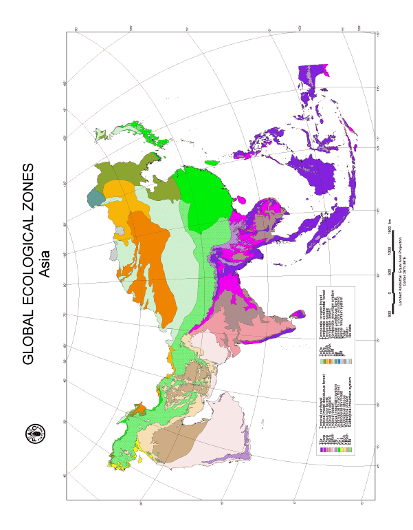
Figure 36. GEZ map of Asia.
Table 21. Global Ecological Zones of Asia.
Surface area | |||
Km2 |
% of total land area Region |
% of GEZ worldtotal | |
|
Tropical rain forest |
3 009 375 |
11.1 |
20.6 |
|
Tropical moist deciduous forest |
1 379 477 |
5.1 |
12.5 |
|
Tropical dry forest |
1 426 603 |
5.2 |
19.1 |
|
Tropical shrubland |
1 167 107 |
4.3 |
14.0 |
|
Tropical desert |
2 704 536 |
9.9 |
23.4 |
|
Tropical mountain systems |
834 931 |
3.1 |
18.5 |
|
Subtropical humid forest |
2 047 862 |
7.5 |
43.7 |
|
Subtropical dry forest |
129 040 |
0.5 |
8.1 |
|
Subtropical steppe |
1 180 330 |
4.3 |
2.4 |
|
Subtropical desert |
1 446 347 |
5.3 |
21.7 |
|
Subtropical mountain systems |
3 459 622 |
12.7 |
71.2 |
|
Temperate oceanic forest |
0 |
0 |
0 |
|
Temperate continental forest |
1 253 135 |
4.6 |
18.0 |
|
Temperate steppe |
1 115 606 |
4.1 |
18.9 |
|
Temperate desert |
2 181 946 |
8.0 |
40.4 |
|
Temperate mountain systems |
3 604 836 |
13.2 |
49.9 |
|
Boreal coniferous forest |
157 450 |
0.6 |
1.9 |
|
Boreal tundra woodland |
0 |
0 |
0 |
|
Boreal mountain systems |
109 168 |
0.4 |
1.7 |
|
Total land area |
27 207 371 |
99.9 |
|
This Ecological Zone covers most of the Malay Archipelago stretching across the Equator and parts of Continental Asia.
Climate
The climate of Tropical Asia is under influence of the Intertropical Convergence Zone (ITCZ). The western coasts of the continent are very wet, due to heavy rains brought by the southwest monsoon. These strong winds bring moisture from the Indian Ocean and are interrupted by the Indian Ghâts, the mountains of Sri Lanka, eastern Himalayas and the mountain ranges of Myanmar and Cambodia. Deviating from this general pattern, in Viet Nam and Philippines the eastern coasts are very wet. In winter, the northeast monsoon brings moisture from the Pacific Ocean. Across the zone, annual rainfall is everywhere more than 1000 mm and often more than 2000 mm. In the equatorial regions, there is no dry season. Everywhere else, there is a short dry season of 1 to 4 months, even up to 5 months in some parts of India, Sri Lanka, Bangladesh and Myanmar. Temperatures are always high: mean temperature of the coldest month is often more than 20°C, sometimes lower due to rainfall occurring throughout the year. Within these general conditions, many variations can be distinguished.
Physiography
This extensive Ecological Zone concerns several different regions:
Southwestern coasts of India and Sri Lanka
South India and Sri Lanka are part of the ancient Gondwana continent. These old Precambrian rocks were metamorphosed, eroded and then faulted and uplifted during Tertiary; this resulted in the formation of the Western Ghâts in India and central mountains of Sri Lanka. In southwestern Sri Lanka, the complex of Precambrian shales/gneiss/granites forms successive plains of various elevations from the mountain to the coast. In India, the coastal plain is formed of recent alluvia.
Malaya and the Philippines
Indonesia with Brunei and Sarawak, Timor and Papua-New-Guinea form the main part of the region, with about 3000 islands stretching over more than 6000 km from west to east. On the foothills of the mountains forming the backbone of most of them, lowlands are more or less extensive, depending on the size of the islands. Coastlines have various features: large estuaries and swamps on some parts like in eastern Sumatra, rocky coasts, coral reefs in other parts. Sumatra, Java, the lesser Sundas, Sulawesi, Halmahera are the main islands with active volcanoes; fertile soils cover the ancient lava flows. Borneo, Timor and New-Guinea are mostly constituted from disaggregated ancient rocks, generally leached and poor. The Philippines Archipelago comprises about 7000 islands, 8 major ones, extending roughly in a north-south direction. On Luzon, Mindanao and Mindoro, central mountains reach more than 2000 m altitude, rising above low, often swampy valleys. On the other islands, hills are of lower elevation and the coastal plains are developed in varying degrees. Peninsular Malaysia belongs geologically to the heart of the Asian continent. It is formed of a central granitic mountain stretching from the north to the south, surrounded by sedimentary lowlands. On the western part, some calcareous hills rise above the plain. The western and southern lowlands are often swampy.
Peninsular Thailand, coastal lowlands of Myanmar and eastern Himalayan foothill
Peninsular Thailand prolongs to the north the Malaysian peninsula, with a narrow coastal plain and the Tenasserim range, below 1500 m altitude, formed of Precambrian and granite rocks. To the north, the Tenasserim range gives way to Shan plateau in Myanmar, which elevation is slightly above 1000 m; it is composed of Precambrian and Secondary rocks. It overhangs the central basin formed of Tertiary sediments and irrigated by Irrawady River. The western coast of Myanmar is formed by the Arakan range, made of folded Primary to Tertiary rocks. Its elevation is slightly more than 1000 m. To the north, the arc-shaped assamo-birman ranges reach the eastern Himalayas. Their lower slopes, formed of Tertiary sandstones, clays and marls, merge into the alluvia of Brahmaputra valley and Gangetic plain.
South-east Asia
In central Thailand, a range of hills crosses the country from the north to the south and catches a part of the southwest monsoon. In Cambodia, the zone covers most of the Cardamomes Hills, formed of Cretaceous sandstones. In Laos, most of the lower slopes of the mountains belong to this GEZ. In Viet Nam, it concerns the lower northeastern slopes of the Annamitic range and the southern plateaux of Kontum, Dar Lac, Lang Bian. The Annamitic range is formed of ancient crystalline rocks covered with sandstones and lava flows, rising above the China Sea. The southern plateaux are made of sandstones partially covered with basalts producing fertile soils. Far to the south, Ca Mau peninsula is the most southern point of the Mekong Delta.
Vegetation
In the wettest parts of this extensive Ecological Zone, the prevailing vegetation type is dense moist evergreeen forest. Floristic variations exist, depending on the location. The most striking difference is the occurrence of Dipterocarpaceae, an important Asian endemic family, to the west of the Wallaces line, whereas they are totally absent to the east of this line. As these forests grow in lowlands, they are under greatest pressure for timber exploitation and conversion to agricultural land. The Sundarbans mangrove forests of the Ganges Delta and those of western New Guinea are by far the most extensive in the world. In the drier parts of the area, mainly in eastern Indonesia and the Himalayas foothill, semi-deciduous or moist deciduous forests occur; especially in the Brahmaputra valley, they are valuable Sal forests (Shorea robusta). Due to many climatic and floristic variations, 8 ecofloristic zones have been distinguished within this GEZ.
The lushest and richest rain forests are found in the Malay Archipelago, harbouring a very rich and diverse flora. Over half (220) of the worlds flowering plant families are represented, as well as about one-quarter of the genera (2400), of which about 40% are endemic; there are between 25 000 and 30 000 species, of which about one-third are trees more than 10 cm in diameter. Rain forests west of the Wallace line are dominated by Dipterocarpaceae, which are extremely diverse in genera and species. They contribute many (Sumatra, Malaysia), most (Borneo) or all (Philippines) of the top canopy giant trees. The tallest trees occur, not as single emergents about 60 m tall, but as groups, giving the upper forest canopy a rough appearance. The chief genera are Dipterocarpus, Shorea, Dryobalanops and Hopea. Other important tree families include Anacardiaceae, Ebenaceae, Leguminosae, Sapindaceae, Euphorbiaceae and Dilleniaceae. Pometia (Sapindaceae), Canarium (Burseraceae), Cryptocarya (Lauraceae), Terminalia (Combretaceae), Syzygium (Myrtaceae), Casuarina (Casuarinaceae), Araucaria are among the chief tree genera of the forests east of the Wallace line. The forests may be divided into various formations with distinctive structure and physiognomy. The formations occupy different habitats and species are restricted to one formation to various degrees. Some are endemic to a single formation: for example, ramin (Gonostylus bancanus) is confined to peat swamp forest. Lowland evergreen and semi-evergreen forests (on dry terrain) are the most extensive formations. Important edaphic formations are heath forest (found on podzols), rain forest over limestone, peat swamp forest (along the coasts of East Sumatra, Peninsular Malaysia and Borneo) and fresh-water swamp forest.
The Asian mangroves, most widely distributed in the Indonesian archipelago and the Sundarbans, are richer in species than those anywhere in the world. Mangrove forests can reach heights of 30 40 m and are best developed in sheltered bays or in extensive estuaries. Conspicuous species of Asian mangroves are Avicennia alba, A. officinalis, A. marina, Bruguiera cylindrica, B. gymnorrhiza, Ceriops decandra, Excoecaria agallocha, Rhizophora apiculata, R. mucronata, Sonneratia alba, S. caseolaris and Nipa fruticans.
Climate
Where the southwest monsoon influence becomes lighter, rainfall decreases and the winter dry season is more pronounced. In these areas, mostly confined to Continental Asia, rainfall is generally between 1000 and 2000 mm, sometimes more, but there is always a dry season of at least 3-4 months like in Papua-New-Guinea and sometimes more than 6 months like in India. Temperatures are always high, with mean temperature of the coldest month generally more than 20°C, sometimes slightly lower, like in northern India or Myanmar or in the indo-Chinese peninsula.
In China, the southern part of Lezhou and Hainan Island experience a similar climate. Annual mean temperature varies between 22-28oC, January mean 16-20oC, minimum above 0-4oC. Annual rainfall ranges from 1300 to 2800 mm, however many locations only receive 800-900 mm annually. Inter-annual variability is high a dry year may only receive 1100-1300 mm, while a wet year can get as much as 3000 mm. The rainy season is from May to November, with frequent typhoon and rainstorm visits. The dry season is between December and April.
Physiography
In Sri Lanka, most of the lowlands, to the north and east of the hills, belong to this Ecological Zone. The coast is flat and sandy with lagoons and swamps. Except some coastal alluvia, most of the area lies on the old complex of shales/gneiss/granite. In western India, the coastal plain around Bombay extends on the Deccan traps, giving rise to ferralitic soils due to the still high rainfall (more than 2000 mm). In northern India, the Ecological Zone extends on the eastern ridge of the Deccan plateau and the alluvial plain of the Ganges River. On its border, the Deccan plateau slightly rises in the Eastern Ghâts (1640 m) and the Chota Nagpur plateau (800-1000 m), composed of uplift crystalline peneplains covered with ferralitic soils. Then, some lower plateaux lead to the alluvial plain of the Ganges River, becoming a huge delta in Bangladesh. In Assam, the northern slopes of Shillong plateau (crystalline hill) and the Mikir Hills, rising on the Brahmaputra valley, belong to this GEZ. In Myanmar, the Ecological Zone concerns the hilly Tertiary basin forming most of the country, between the Arakan range and Shan plateau: the elevation ranges from 200 to 1000 m. In Thailand, it is the foothill of the northern and western mountains, between 200 and 800-1000 m. In northern Viet Nam, the Red River valley belongs to this Ecological Zone with the lower foothills of the surrounding mountains and the delta built by the alluvia and spread with calcareous, gneissic or granitic hillocks. In southern Viet Nam, Laos and Cambodia, the GEZ lies on the low plateaux on the western side of the Annamitic range: they are formed of sandstones, sometimes covered with lava flows inducing fertile red soils. In the Philippines, the western foothills of the ranges are included, as well as more or less narrow plains, often swampy. In the small Sunda islands the Ecological Zone lies on the lower mountains slopes, whereas in New-Guinea, the low, flat, often swampy plains of the southern part are included.
China: Granite intrusion-formed mountains occupy central to southern parts of Hainan Island in a radiating pattern, with average altitudes exceeding 1000 m and the main peak, Wuzhishan, reaching at 1867 m. The outer peaks are gradually reduced to low rolling hills under 500 m, with basins and terraces scattered alternately. Lezhou Peninsula is on average 100 m in elevation. Soil distribution is related to altitude: Red soil and latosol under 500 m, mountain Yellow soil between 500 and 1000 m, mountain Yellow-Brown soil above 1000 m. Drier areas have Red-cinnamon soils, while marine sandy soils and marine saline soils occur along seashores.
Vegetation
Due to the dry season, the natural vegetation is nearly everywhere a deciduous or semi-deciduous forest. This forest type is in Asia commonly known as monsoon forest. Its flora varies according to the region and the actual leafless period varies between species. On average, moist deciduous forests are leafless for at least 8 weeks in February and March. Many dominant trees belong to the Leguminosae, Combretaceae, Meliaceae or Verbenaceae. Dipterocarps are also present, but less conspicuous as in the rain forest. The forest is 20 to 25 m tall and a sparse grass cover is usually present. Teak forests (Tectona grandis) in west and north Thailand, Laos, Burma and Peninsular India and sal forests (Shorea robusta) in east India and the Ganges valley are of great economic value. Associating trees of the teak forest include Lagerstroemia, Xylia kerrii, Adina cordifolia, Vitex, Tetrameles nudiflora, Afzelia xylocarpa, Diospyros, Sindora cochinchinensis, Pinus merkusii, in the sal forests tree species of Dillenia, Terminalia, Adina, Pterospermum are co-dominant. Bamboo brakes (Dendrocalamus strictus) are common in India and Myanmar, often in secondary stages. Extensive deciduous forests remain on hilly parts of Myanmar and some patches in northern Viet Nam, on the Red River plain. In the remaining part of Indochina, the Ecological Zone is widely covered with deciduous Dipterocarp forest and teak forest. In Papua-New-Guinea, there is a different type of dry evergreen or semi-evergreen deciduous forest, characterized by species such as Garuga floribunda, Protium macgregorii, Intsia bijuga, Acacia spp. (Mimosaceae) and presence of Myrtaceae, Proteaceae and Rutaceae.
In China, tropical moist deciduous forest is found below 700 m in basins and river valleys of southern mountains on Hainan Island. The upper canopy is 30-40 m tall, with main species: Heritiera parvifolia, Amesiodendron chinense, Litchi chinensis, Vatica hainanensis, Diospyros hainanensis, Hopea hainanensis, Lithocarpus fenzelianus, Homalium hainanensis, Podocarpus imbricatus, etc. The middle layer of the rain forest often includes Dysoxylum binectariferum, Sindora glabra, Ormosia balansae, Pterospermum heterophyllum, Gironniera subaequalis, Schefflera octophylla, Dillenia turbinata, Hydnocarpus hainanensis. Understorey is composed of Ardisia quinquegona, Psychotria rubra, Lasianthus kwangtungensis, Arenga pinnata, Pinaga baviensis, Caryota mitis. Hill moist forest grows at 700-1200 m altitude and is composed of Altingia obovata, Manglietia hainanensis, Michelia balansae, Madhuca hainanensis and species of Fagaceae, Lauraceae, Theaceae and Aquifoliaceae. In the central part of the island, coniferous forests grow on low mountains and hills at altitudes below 800 m. Pinus latteri dominates and forms second growth pure forests or mixtures with Liquidambar formosana, Chukrasia tabularis and Engelhardtia roxburghii. Mangrove forests grow along shorelines around the island except the west coast. Tree species include Avicennia marina, Rhizophora mucronata, R. apiculata, Bruguiera conjugata, B. cylindrica, Ceriops tagal, Sonneratia acida, Xylocarpus granatum and others.
Climate
In areas particularly sheltered from the humid winds blowing from the oceans, the climate is dry, with a long winter dry season. It is the case on the eastern ridge of the western Ghâts of India, in the northern and southern coastal plains of Sri Lanka, but also along the eastern coast of India and in the heart of Myanmar and Thailand. These areas weakly receive, in summer, the southwest monsoon, either due to a mountainous barrier or to a continental location. Whereas in winter, they are influenced by the northeast monsoon: dry cool winds that reach these countries after crossing China and Siberia. In central Cambodia and Viet Nam, the northeast monsoon is dry and warm. Narrow coastal stretches of this climatic type also occur in southern Papua-New-Guinea. Rainfall ranges between 1000 and 1500 mm, with a dry season of 5 to 7 or 8 months. Mean temperature of the coldest month is always more than 15°C, often 20°C.
Physiography
In India and Sri Lanka, the Ecological Zone comprises:
- The coastal plains along the Gulf of Bengal; the very flat plains, generally lower than 300-500 m, are underlain by the ancient granito-gneissic complex and covered, in some parts, by more recent alluvia. Under this dry climate, soils are mostly tropical ferrugineous soils, sometimes lateritic.
- The northeastern part of the Deccan plateau. This plateau generally looks like a peneplain formed of the Precambrian complex eroded, sometimes folded again (Aravalli Hills), partially overlain by Deccan traps. Soils are ferrugineous, locally with black soils on traps.
In Myanmar, this GEZ concerns the Tertiary basin around Mandalay. In Thailand, the Ecological Zone extends on the wide and flat alluvial basin of Chao Phraya River, only broken by some Permian calcareous hillocks. Moreover, the whole Korat plateau, bordered by the Khao Khien mounts and Dangreks on its western and southern ridges and by the Mekong River valley to the north and to the east, belongs to the same Ecological Zone. It is a gently rolling surface with an elevation of 200 to 400 m. It consists of sandstone outcrops, with poor drainage inducing floods during the rainy season and lack of water during the long dry period. In Cambodia, the concerned area is the whole low central plain built by the lower Mekong River and the Tonle Sap. This flat alluvial plain less than 100 m elevation is broken by inselbergs of various origins and by low basaltic plateaux (100-200 m) to the east of the Mekong River. In Viet Nam, the Mekong delta makes part of this zone.
Vegetation
A complex of vegetation types are found in this Ecological Zone. Dry evergreen forest occurs on the dry eastern Coromandel Coast of India and in north Sri Lanka. This very peculiar and vestigial plant community is unknown elsewhere in Asia and is limited to a small area. Today, most of these forests have been cleared for agriculture and locally replaced by Casuarina equisetifolia and Eucalyptus plantations. The ecologically decisive factors include the rainfall regime with well-marked maxima in October, November or December and a summer of 5 7 dry months. This rainfall pattern is uncommon in the tropics. The natural vegetation is a stunted woody formation with a peculiar floristic composition, including Manilkara hexandra, Chloroxylon swietenia, Albizia amara and Capparis zeylanica. The total flora is poor.
Dry deciduous dipterocarp forests and woodlands are more common and have their main distribution in Viet Nam, Laos, Cambodia and Thailand. The crown density of the woodlands varies from 10 to 40%. The repeated occurrence of fires and the pronounced dry season are certainly determining factors for this open structure. These woodlands are mainly found on acid lithosols and podsols, soils with a low fertility. These conditions determine a quite stable and open formation with a few characteristic dipterocarp species (Dipterocarpus intricatus, D. obtusifolius, D. tuberculatus, Pentacme siamensis, Shorea obtuse), a common Cycas (C. siamensis) and a dwarf bamboo (Arundinaria falcate) in the undergrowth. In Thailand, some of these woodlands include teak (Tectona grandis) and a pine species (Pinus merkusii).
In mixed deciduous woodlands, teak and pine occur with dipterocarps or Leguminoseae. They are found in Thailand, Myanmar, Laos and Vietnam. In India, woodlands are common as well but only a few dipterocarps occur, notably Shorea robusta and S. talura. In southern Papua-New-Guinea, some dry deciduous forests with Myrtaceae and Eucalyptus woodlands occur on a narrow coastal zone.
Climate
This Ecological Zone extends over the main part of Peninsular India, where rainfall varies from 500 to 1000 mm, or even from 200 to 500 mm in its northeastern part, with a long dry season during 7-11 months and warm temperatures (mean temperature of the coldest month>20°C). Similar conditions occur in some small Sunda Islands as well as in a narrow coastal zone of southern Viet Nam.
Physiography
The Deccan plateau is a part of the Indian Shield. Its monotonous rocky surface is formed of the ancient granite-gneissic complex overlain, in its central part, by a thick cover of lava flows. Its mean elevation is 600 to 1000 m. To the northwest, the Indian Shield merges under the Indus alluvia.
Vegetation
In these very dry conditions, only a low open forest can grow, often giving way to woodland, savanna woodland or thickets. Moreover, in densely populated India most of this area is devoted to cultivation and grazing. Stretches of poor degraded savanna or pseudo-steppe intermingle with the crops. The thickets are composed of thorny bushes of Acacia, Capparis, Maytenus and Ziziphus. In semi-arid Rajasthan, in the northwest of India, Sudano-Deccanian floristic elements prevail. Some thorny thickets and low forest types dominated by Anogeissus pendula can be considered as a virtual climax. In these formations, several Acacia species (A. jacquemontii, A. leucophloea), Prosopis, Salvadora and Capparis are common shrubs. In southeastern Viet Nam and Indonesia, the low deciduous forest often gives way to a sclerophyllous thicket.
The main Asian tropical deserts include the Thar Desert on the border of India and Pakistan and the southern half of the Arabian Peninsula.
Climate
In Rajasthan, westwards, rainfall rather suddenly drops down and the border with Pakistan is the Thar Desert. Rainfall is there less than 200 mm, with hazardous rains. Winters are rather cool; mean temperature of the coldest month may be lower than 15°C. The Rann of Kutch, to the south, is also a desert.
In the Arabian Desert, rainfall is very scarce and erratic. Average annual rainfall ranges from 0 to 100 mm, with 25-50 mm for the greater part of the region and rainless years are not uncommon. Temperatures are very high throughout the year, with the mean coldest month always above 10oC. The eastern desert in Yemen is among the hottest places on earth, the absolute maximum reaching more than 40oC and the minimum not much less than 20oC.
Physiography
The Ecological Zone extends on the Thar Desert sands and on the saline soils of the Rann of Kutch. In Arabia, relief is more pronounced, particularly in the western part. Soil development is poor and four major soil types are present: sandy soils in different forms; hammadas ranging from solid rock to soft gypsiferous soil including pebbly and gravely desert ground; loess and similar soils; hydro-saline soils including marshes, sebkhas and the like.
Vegetation
In some places, between the dunes, a pseudo-steppic vegetation may occur. Sandy or rocky
deserts are extensive.
The boundery of the Tropical desert in the Arabian Peninsula is based on the presence of tropical plants (south of this line) belonging to the Sudanian Region. The sparse vegetation consists of perennial shrubs, bushes, succulents and grasses. Acacia flora is the indicator of the region with plants like Balanites, Abutilon, Haloxylon, Retametalia, Eremopogon, Trichodesma, Cucumis, Cenchrus, Cyperus, Tribulus, Maerua, Boscia, Tephrosia, Rynchosia, Periploca, Pergularia. Thorny thickets of Acacia tortilis and Maerua crassifolia characterize the foothills. Panicum turgidum, Lasiurus hirsutus are found in sandy plains, Yemen and the Hadramut.
The tropical mountain systems of Asia include: a) the eastern Himalayas b) a mountain range stretching from the north of Indochina, Tibet, to the backbone of Malaysian peninsula; it is followed, to the south-east, by the Annamitic range; c) central mountain ranges of the main islands in Indonesia and the Philippines; d) relatively high peaks (more than 2000 m) in India and Sri Lanka and e) mountains in the southwest of the Arabian Peninsula.
Climate
Most tropical mountains of Asia, i.e. those reaching at least 1500 to 2000 m, experience a wet climate. Regarding the Himalayas, they are climatically divided into a subtropical northwestern part and a tropical wet southeastern part. Nepal is a transitional region between these two units. In all tropical mountains, from 1000-1500 m to 4000 m, annual precipitation is more than 1000 mm, sometimes more than 2000 mm. There is a pronounced dry season of 3 to 5 months on the submontane zone of eastern Himalayas, with mean temperature of the coldest month more than 15°C. Everywhere else, the dry season, if it occurs, is very short (less than 3 months). Mean temperature of the coldest month rapidly becomes lower than 15°C with increasing elevation. Above 4500 to 5000 m, eternal snow is found.
The mountains in the southwest of the Arabian Peninsula have a drier climate. Annual rainfall ranges from 400 mm at the lower foothills to 800 mm on the higher escarpments and there are two rainy seasons: in March-April and from July to September.
Physiography
Himalayas
The eastern part of the Himalayas, first oriented west-east in eastern Nepal, Sikkim and Bhutan, takes then a northeast direction. It is composed of two parallel ranges with contracted folds: Low Himalayas, reaching 2000 to 3400 m and Great Himalayas to the north, reaching more than 6000 m. It is interrupted in its eastern end by the high Brahmaputra valley. The highest peaks, reaching more than 8000 m, are located in Nepal.
Northern Indochina, Myanmar and Thailand
This important mountain block, south of Tibet, is formed of north-south folds with steep slopes. It is prolonged by the Arakan range, of which the Secondary and Tertiary rocks follow the Bay of Bengal. On the bordering region between India and Myanmar, the range reaches 2000 to 3000 m. In Malaya, the central mountains consist of crystalline blocks and rarely exceed 2000 m. In northern Thailand, some calcareous crests are more than 1500 m and the Doi Inthanon reaches 2580 m. In northern Laos and Viet Nam, the Annamitic range may be divided into the crystalline block of Phou Houat (2400 m) to the north and the proper Annamitic Cordillera going further to the south, dotted with high granitic blocks (up to 2800 m).
Indonesia and Philippines
In Sumatra, Java, the small Sunda islands, Sulawesi and Halmahera, active volcanoes form the highest peaks (above 3000 m). In Borneo, Timor, New Guinea, the mountains are crystalline blocks; the highest one, in Irian Jaya, is the Gunung Jaya (5030 m)
Arabian Peninsula
The higher peaks in the southwest reach an altitude of 3800 m. The terrain is composed of plateaux, basins hills and slopes. Soils are shallow, rocky or stony, only on cultivated terraces soils are developed. Valleys and wadis with sedimentary soils are rare.
Vegetation
Himalayas
Forests generally cover the Himalayas slopes up to 4000 m. In the lower reaches, these forests are often degraded by shifting cultivation and admixed with thickets. In the widest valleys crops are being cultivated, mostly rice and maize. Around Darjeeling, important tea plantations extend. In this part of the Himalayas we find the following sequence of vegetation formations: at around 1000 m, tropical lowland forest is replaced by an evergreen forest, with Castanopsis, Schima, Engelhardtia, Lithocarpus and locally Himalayan chir pine forest (Pinus roxburghii). From 2000 to 3000 m is a belt of evergreen oak forest, followed higher-up by coniferous forest (Abies, Tsuga) and then giant Rhododendrons up to 4000-4500 m. Above this altitude, dwarf shrubs and grassland occurs up to 5000-5500 m.
South-east Asia
In Myanmar and Thailand, evergreen oak forests are found above 1500 m with pine forest, followed by Rhododendrons. In Laos and Viet Nam, an evergreen forest with Lauraceae and Fagaceae grows from 1500 to 2000 m and a mixed broad-leaved/conifers forest takes over above this elevation. Woodlands with oaks and pines also occur at high altitude. In Thailand, northern Laos and Viet Nam, these forests are largely affected by shifting cultivation. Nowadays, mozaics of forests and thickets predominate the lower montane zones.
Malaya Archipelago
In Malaysia, as well as in Indonesia and the Philippines, the montane (evergreen) rain forest still covers relatively larger areas as logging mostly affected lowland forests. This forest is best developed between 1400 and 2400 m altitude and is characterized by Fagaceae (Castanopsis, Lithocarpus, Nothofagus in New Guinea), Lauraceae, Junglandaceae (Engelhardtia), Magnoliaceae (Casuarina junghuniana), conifers (Podocarpus, Pinus in Sumatra), Dacrydium, Aracauria, Libocedrus, Phylocladus and others. Montane rainforest is often affected by shifting cultivation. In the subalpine zone, between 2400 and 4000 m, we find dense or discontinuous montane thickets with Ericaceae (Rhododendron, Gaulteria), Vacciniaceae and Myrsinaceae. Pine forest of Aracauria, Podocarpus and/or Libocedrus often occurs in this belt. The Alpine zone extends above 4000 m altitude and the main vegetation is grassland and discontinuous low scrubs.
Arabian Peninsula
Mountains are the only locations in the Peninsula where forests grow. A number of distinct vegetation zones can be distinguished, related to altitude:
- from around 1000 to 1500-1800 m: Acacia-Commiphora deciduous scrub or savanna, with species such as Acacia asak, Acacia mellifera, Grewia spp.. Commiphora spp. are also abundant with Anisotes trisulcus. In the south, succulents like Euphorbia cactus and Euphorbia inarticulate appear, while in wadis we find Zizyphus spina-christi.
- 1500-1800 to 2000 m: evergreen woodland or forest with Oleeta africana, Podocarpeta, Olea chrysophylla, Trochonanhus comphoratus and other species.
- 2000 to 3000 m: coniferous forest of Juniperus procera.
This Ecological Zone has its main distribution in East Asia, i.e. southeast China south of the Yangtze River, the southern tip of South Korea and the southern half of Japan. There are two distinct small geographic units in the Middle East: the western part comprises the Colchis, humid forests at the mountain foot of the Caucasus, extending further westward along the Black Sea and also referred to as Euxinian forest, while the eastern area, or belongs to the foothills of the Talysh mountains at the Caspian Sea.
Climate
East Asia
Winters are mild to warm and summers are hot and wet. Generally, winter temperatures are heavily influenced by northerly cold fronts from Siberia. In summer the Pacific monsoon brings large amounts of precipitation to the region.
China and Korea Peninsula: annual mean temperatures range from 15-17oC in the northern part of the zone to around 21oC in the south and southeast. Inland low mountains and hills are slightly cooler than coastal plains. Annual precipitation varies between 800 and 1300 mm throughout the northern region, while further south it becomes wetter, up to 1800 mm and sometimes 2500 mm in low mountains. Annual rainfall diminishes going west, away from the coast. In the northern and middle parts of the zone rainfall is evenly distributed over the year. In the south the climate is under influence of Indian Ocean monsoons and most of the rain falls during the rainy season between May and October. A dry season of November to April is distinctive, during which hardly any rainfall is expected. The island of Taiwan is also under strong influence of the maritime monsoon climate. Annual mean temperature here ranges from 21o in the north to 25oC in the south. Annual rainfall is between 1500 and 2000 mm.
Japan: the climate is influenced greatly by the monsoon. In winter, there is a prevailing cold and dry northwest wind. Warm and moist southeast winds prevail during summer. Generally speaking, the summers are very hot and the winters rather cold with snow and frosts. Mean annual temperature is around 14o 17oC. Mean temperatures of the coldest month (January) range from 3o to 7o and those of the warmest month between 26o and 28oC. The yearly precipitation over most of Japan is much greater than that over the continent. Mean annual precipitation ranges from around 1200 mm to locally more than 2500 mm, with two peak rainy seasons: Baiu (June-July) and Shurin (autumn rain).
Middle East
The climate of the coastal plains and lowlands bordering the south of the Black Sea and the Caspian Sea is warm-temperate with an annual average temperature around 14-15°C. High amounts of precipitation throughout the whole year are characteristic (mean yearly precipitation around 1500-2000 mm, locally up to 4000 mm). This high humidity results from the upward gradient rains of water-saturated air at foot of the High and Low Caucasus. In the Colchis the climate is mild due to the influence of the Black Sea (yearly amplitude of the monthly average temperatures 15-19°C), with mild winters (average temperature of the coldest month 5-6 °C). The winter snow coverage protects the vegetation against the occasional frosts and enables the occurrence of thermophytic forests even at higher altitudes.
Physiography
China: the zone is flat in the northeastern coastal plains and hilly in western as well as southern parts. Sichuan Province in the northwest of the zone concerns a large basin formed by eastern rim of the Tibetan Plateau to its west, Yungui Plateau to its south, Qinling Range to its north and hilly southwestern part of the zone to its east. In northeastern area of the zone is The Yangtze River Delta, in the northeast, encompasses parts of Jiangsu, Anhui, Zhejiang, Hunan, Jiangxi and Shanghai City. Numerous low mountains and hills predominate southeastern China and their altitudes are usually below 1,000 m. A few mountains exceeding 1400 m are Tianmushan (1506 m), Baishanzhu (1800 m) and Huangshan (the Yellow Mountain, 1860 m). Yellow brown soils and mountain yellow soils are common in mountain areas, yellow cinnamon soil prevails in basins and plains. The Yungui Plateau averages above 1500-2500 m, higher towards its northwest corner (4000 m), but descending gradually to 500 m in the south. On the plateau surface, red earth is most common, yellow soils, yellowish brown soils and brown forest soils predominate in mountain areas, while humic carbonat soils and terra rossa are distributed over limestone regions. Taiwan is dominated by uplands and mountains occupy 70 percent of the total area. Western slopes of the Alishan become gradually level and connect to low hills and alluvial plains. Latosols cover large areas below 500 m, mountain red soils and mountain yellow soils are distributed between 500 and 1500 m.
The topography of Japan is very complicated and mountainous; there are many valleys and small plains among the mountain ranges. Volcanoes and tectonic lines are common. Many kinds of rocks belonging to various groups, systems and series can be found. In southwestern subtropical Japan, strata of Palaeozoic and Mesozoic origin predominate. Brown forest soils are the most common soils. Other important soil types are black soils of volcanic origin and red and yellow soils.
The coastal plains of the Black Sea and Caspian Sea were produced by the retreat of these seas. Altitude ranges from the lowlands up to 600 m, but particular forest stands still occur around 900 m. The lowland is essentially formed by fluvial accumulative deposits. Red-soils and different types of yellow soils are characteristic for the Ecological Zone. Red-soils (partly fossil) are restricted to the damp Colchis climate. On sites in the foothills also yellow-brown soils and some types of montane brown forest soils are found. Alternating with these soil types humus carbonate soil (rendzina) and alluvial soils occur.
Vegetation
China
Two types of woody vegetation prevail south of Yangtze River in eastern China: pine forest and deciduous forest mixed with evergreen species. The dominant conifer here is Pinus massoniana, which grows extensively on slopes of low mountains and hills. The mixed deciduous evergreen forests, dominated by deciduous trees, are a unique subtropical vegetation type in China. Species of this formation include: Quercus acutissima, Q. variabilis, Q. dentata, Q. glandulifera, Q. fabri, Liquidambar formosana, Pistacia chinensis, Ulmus parvifolia, Zelkova schneideriana, Celtis sinensis, Dalbergia hupeana, Albizia macrophylla, Tilia miqueliana, Cyclobalanopsis glauca, C. myrsinaefolia, Castanopsis sclerophylla, C. carlesii, Lithocarpus glaber, Phoebe sheareri, Cinnamomum chekiangense, Machilus thunbergii and Ilex purpurea. Bamboo stands are very well cultivated in the region, with more than 20 species in Phyllostachys of which P. edulis is most common.
Western mid-latitude mountains feature small conifer forests of warm-climate, dominated by spruce-fir such as Abies chensiensis, A. fargesii, A. ernestii, Picea complanata, P. neoveitchii, as well as Pinus armandi, P. henryi and Platycladus orientalis. Pinus tabulaeformis and P. bungeana forests are distributed over western portions of the Qinling range. Deciduous broadleaved forests contain more than 300 woody species, the major trees including Quercus acutissima, Q. variabilis, Q. liaotungensis, Q. aliena var. acuteserrata, Q. dentata, Q. glandulifera, Betula albo-sinensis, Toxicodendron vernicifluum, etc.
In the southeastern low mountain and hill region as well as the Sichuan Basin, the vegetation is typically represented by evergreen broadleaved forests as well as coniferous forests. Consistently distributed in the entire region is evergreen broadleaved laurel forest of Cyclobalanopsis glauca. Then there are Castanopsis eyrei and C. fargesii in the central to northern parts of the area, C. hystrix and C. lamontii from west to east sides of the Nanling mountains. Conifer forests are primarily those of Pinus massoniana, P. taiwanensis and Cunninghamia lanceolata. Pinus massoniana occupies slopes with acid soils, mostly below 800 m. In the western part of the division it may occur up to 1000 m. This species is highly capable of natural regeneration and is tolerant to dry, poor site conditions. The distribution of P. taiwanensis displays a discrete island pattern and is common on acid base rocks with average elevations above 800 m and upper limit to 2000 m. Cunninghamia lanceolata is also widely distributed, primarily on acid soil slopes below 1200 m altitude. The region is one of the most important bamboo regions in China. There are two million hectares of Phyllostachys edulis in the area. Several other species from the same genus also occupy a broad range: Ph. bambusoides, Ph. nidularis, Ph. mannii, Ph. nigra var. henonis and Ph. heteroclada.
On Yungui Plateau in south and southwest China, regional evergreen broadleaved laurel forests are similar to those of eastern areas, consisting of same genera, Castanopsis, Lithocarpus, Cyclobalanopsis, Cinnamomum and Phoebe, but often with different species. The conifer forest here is dominated by Pinus yunnanensis, which grows widely on the plateau surface and mountainous fields at 1000-3100 m in elevation, pure stands usually at 1600-2800 m.
Taiwans forests are distributed along a distinct gradient from the coastal region to high mountains. Mangrove forests primarily occur along shallow shorelines. Southern subtropical rain forest covers low hills (below 500 m) in northern Taiwan. Major upper storey species include Cyclobalanopsis glauca, Castanopsis carlesii, C. kusanoi, Ficus microcarpa, Cryptocarya chinensis, Acer oblonga, Elaeocarpu japonica, Illex rotunda and Engelhardtia roxburghiana. Many middle and under story species occur, along with tree ferns up to 10 m tall scattered within the forests. Many of the rain forests have been cleared for citrus orchards, eucalyptus forests and Phyllostachys edulis or Ph. makinoi plantations. Evergreen broadleaved forests extend on 500-1800 m slopes and comprise Castanopsis kawakamii, C. fargesii, C. uraiana, Lithocarpus brevicaudatus, L. ternaticupula, L. amygdalifolius, Cinnamomon camphora, etc.
Japan
The predominant natural vegetation is evergreen broadleaved forest, showing several forest types. The major tree species of the overstorey are Machilus thunbergii and Castanopsis cuspidata in coastal areas and Cyclobalanopsis gluaca, C. gilva. C. salicina, C. myrsnaefolia and C. acuta (evergreen oaks) in inland areas. Conifers, such as Podocarpus macrophyllus, P. nagi and Torreya nucifera occur also in these forests. At higher elevations Tsuga sieboldii and Abies firma grow in mixture with the broadleaved evergreen species. The medium to lower strata contain small trees and shrubs of such broadleaved evergreen species as Aucuba japonica, Damnacanthus indicus and Neolitsea sericea. The ground vegetation contains small shrubs, vines, ferns and herbs. Epiphytes are present, as well as many lianas. The natural vegetation including climax forests and other minor communities in this Ecological Zone has been largely altered since rice cultivation was introduced in Japan about two thousand years ago. Secondary forests of Pinus densiflora, Quercus serrata and Quercus acutissima now prevail over large areas on foot-hills and lower mountains. Natural stands of Pinus densiflora are restricted to extreme habitats such as narrow ridges, steep slopes and lava flows with little soils or exposed bedrocks and peripheries of fens and swamps.
Middle East: Hyrcinian forest and Euxinian forest
Although of relatively small extent, these forests are highly significant as they present the most diverse and productive forests in the Middle East. Both forests are dense broadleaved summer-green types.
The vegetation consists of hygro-thermophilous mixed deciduous broad-leaved forests with varying floristic composition and structure, sometimes with an evergreen understorey. Due to the climatic conditions and biogeographic history these forests are rich in endemic and tertiary relict species. The canopy of the forests is build up by different oak species (in the west Quercus imeretina, Q. hartwissiana, in the east Q. castaneifolia), also Castanea sativa, Pterocarya pterocarpa, Diospyros lotus and Fagus sylvatica subsp. orientalis. In the subcanopy layer Zelkova carpinifolia, Carpinus betulus and some Acer species are characteristic. The shrub layer is dense and species-rich. Additionally lianas and epiphytes occur. The herb layer consists of different ferns, grasses and herb species.
At higher altitudes the hygro-thermophilous vegetation is replaced by Caucasian mixed hornbeam-oak forests (Quercus iberica, Carpinus orientalis, Fagus sylvatica subsp. orientalis, Castanea sativa).
Small areas in the lowland, along riversides and the estuaries, are covered by swamp and fen forests (Alnus barbata, A. subcordata, Pterocarya pterocarpa).
In Asia, this Ecological Zone is confined to the Middle East and occupies a relatively narrow belt along the Mediterranean Sea.
Climate
The zone has a typical Mediterranean climate, with mild humid winters and dry, moderately hot summers. Annual rainfall ranges from around 400 to 800 mm and is decreasing from north to south.
Physiography
This zone comprises the coastal plain along the Mediterranean Sea and low hills running parallel to the coast. The northern part of the Jordan-Arava Rift Valley is also included in this zone. The coastal plain is a lowland of varying width. It is a zone of light soils, mobile sand dunes and most fertile alluvial ground. The Mediterranean coastline of Turkey is very complex, consisting of many islands, estuaries and small horsts. Intermountain valleys of the Aegan and Taurus ranges are also part of the zone.
Vegetation
The typical Mediterranean woody vegetation that dominates this zone is maquis, an evergreen sclerophyllous woodland or shrub up to around 5 m high and often dominated by oak. Ceratonia Pistacia lentiscus maquis dominates the coastal plains up to around 200 m, while Quercus calliprinos Pistacia palaestina maquis is the chief vegetation from 200 to 1000-1200 m. Important tree species of the maquis, which has local variants, include Quercus ithaburensis, Q. infectoria, Q. ithaburensis, Q. coccifera, Laurus nobilis, Arbutus andrachna, Cercis siliquastrum, Juniperus phoenica, Myrtus communis, Olea europea, Phillyrea spp., Pinus halepensis, P. brutia and others. Climbers are also present, for instance Tamus communis, Rubia tenuifolia, Smilax aspera, Lonicera etrusca, Clementis. Maquis, when unaffected by man, may under certain conditions develop into a type of forest, dominated by Quercus calliprinos.
Various types of pine forest occur, with either Aleppo pine (Pinus halepensis), P. brutia or P. pinea as dominant species. Pinus pinea, partly introduced by man, grows mainly on sandstone formations, while P. halepensis is confined to rendzina or other chalky soils. The undergrowth is often made up of other maquis components.
This Ecological Zone is confined to western Asia, mainly located in the Middle East.
Climate
The climate of the subtropical steppe is semi-arid. Annual rainfall ranges from about 200 to 500 mm and falls during winter in the Middle East. The subtropical steppes in East Afghanistan and Pakistan are under the influence of the Indian monsoon and receive most of the rainfall from June to September. Although differences in temperature between seasons are relatively high, winters are not severe.
Physiography
As many different geographic regions are part of the zone, physiography is extremely varied. The western part of the zone comprises undulating (piedmont) plains and lower foothills of the Kurdistan and Zagros Mountains, drained by the rivers Euphrates and Tigris. The plains are built mainly of chalks and marls covered by sand and loess. On the lower hills and medium-altitude plateaus, fertile brown soils predominate. In Iran, Afghanistan and Pakistan, all mountainous countries, the steppe zone often forms the transition between low-lying coastal or inland deserts and mountains, comprising the lower foothills.
Vegetation
The dominant steppe vegetation consists of low shrubs and grasses, interspersed with sparse trees particularly at wetter locations. In the Middle East, dominant shrubs include Artemisia spp., Anabasis aphylla, Sarcopoterium spinoasa, Gundelia tournefortii, Haloxylon articulatum, Asphodelus microcarpus and Ominus natrix. At higher, more humid locations a forest-steppe can be found with trees such as Amygdalus korsuhinskii, A. arabica, Acer monspessulanum, Pistacia atlantica, Pyrus bovei, Rhamnus palaestina and Crateagus aronia. Due to a very long human activity, the original vegetation has been considerably altered. In Pakistan, the woody steppe vegetation consists of shrubs and small trees. Main species are Acacia modesta and Olea cuspidate, accompanied by Ziziphu jujuba, Dodonea viscosa and others.
Subtropical deserts in Asia consist of the northern part of the Arabian Peninsula and arid lowlands or inland plateaux in Iran, Afghanistan and Pakistan.
Climate
The climate of the zone is characterized by very low rainfall, > 200 mm annually. Summers are very hot with average temperature of the warmest month ranging from 35 to 40oC and cool winters (mean temperature of the coldest month around 10o - 15oC). The Dasht-e-Kavir depression in Iran, with higher altitudes and further to the north, has a typical continental desert climate, reminiscent of that of Central Asian deserts in moisture deficiency and extreme winter temperatures. Here, the mean annual temperatures vary between 15o and 18oC with extreme maximum temperatures reaching around 40oC and winter extremes well below zero.
Physiography
The Nafud and Syrian deserts are the subtropical deserts of the Arabian Peninsula. Large stretches of the former are covered with layers of Nubian sandstone, which has greatly influenced the nature of the landscape in being the source of sand dunes, sand flats and sand onblows. In addition to the sandstone plateaux, often broken up by lava masses and extinct volcanoes there are also large stretches sand dunes in the Nafud and sand onblows covering the limestone strata. Sheets of gravel are widespread, as well as saline basins. The Syrian Desert is a vast Eocene and Miocene calcareous plateau. The large deserts of Iran are located on the Central Plateau, a vast plateau at 400 800 m altitude almost completely enclosed by high mountain systems. It is built up primarily of highly saline ground. Apart from salines this plateau is also partly covered with takirs and sand dunes.
Vegetation
Vegetation in this zone is dominated by low, thorny shrubs with a sparse coverage. Large parts consist of sand without any vegetation. Compared to the tropical desert, floristic composition is different. In the northern part of the Arabian Peninsula we find a steppe with Artemisia herba-alba, Anabasis articulata, Stipa tortilis, Thymelaea hirsute and Poa sinaica. In the depressions, formations with Zygophyllum dumosum, Salsola tetranda and Chenolea arabica occur. In subtropical deserts of Iran and Afghanistan, sparse shrub vegetation, with a ground coverage between only 1 and 10 percent, predominates. Two types can be distinguished: a) Zygophyllum shrubland with Zygphyllum atriplicoides, Z. eurypterum and b) Haloxylon shrubland with small shrubs and dwarf shrubs like Haloxylon salicornicum, H. ammodendrum, H. articulatum and Seidlitzia rosmarinus. Accompanying species include Anabasis haussknechti, A. setifera, Calligonum spp., Ephedra scoparia and Salsola spp.
In Iran deserts one finds perennial formations with several species of Andropogon, Aristida plumose, Bromus, Cymbopogon laniger, Pennisetum orientale and Chrysopogon ciliotatus. Artemisia and thorny Convolvulus are abundant; shrubs and bushes of Acacia horrida, Populus euphratica, Pistacia khinjuk and Amygdalus scoparia are also present.
Subtropical mountain systems cover extensive areas in Asia, in a nearly continuous west-east belt, from the mountains and highlands of Turkey to the eastern reaches of the Himalayas in South China.
Climate
The climate of the Middle Eastern mountain systems is extremely diverse both in temperature and rainfall. Winter rainfall is predominant in the area and only some small portions enjoy light or heavy summer rains. Compared to lowlands in the region, mountains are generally more humid. A typical highland forest-steppe climate (Kurdistan Mts.) has the following characteristics: annual precipitation, in the form of snow and rain, ranges from 500 to 1400 mm; the rainy season is from around September to May-June, the rest of the summer is dry and hot. Another characteristic is that four or more months of the winter have mean minimum temperatures below 0oC.
All along the Himalayan ranges, the rainfall increases from west to east and the climatic regime changes gradually from Mediterranean to typical monsoon types. The rain decreases also from the outer to the inner parts of the ranges. On this basis, the subtropical part of the Himalayas comprises:
- North-west Himalayas (Afghanistan and Pakistan);
- Kashmir;
- Western Himalayas (Himachal Pradesh, Garwal, Kumaon, Nepal) up to Katmandu.
Kashmir still experiences a typical Mediterranean regime, whereas in western Himalayas, a transitional regime is characterized by a bixeric tendency, even if the monsoon reaches these regions. In the submontane and montane levels, rainfall ranges from less than 1000 to 1500 mm, with at least 1 or 2 dry months, up to 7 or 8. Mean temperature of the coldest month varies from around 15°C in the submontane zone, to less than 10°C above 2000 m. Above 3000 m, snow occurs, with frequent winter frost. Precipitations are 500 to 1000 mm. In Kashmir, high plateaux between 2500 and 5000 m have a subdesert cold climate that might be considered either as subtropical or temperate. Rainfall is less than 400 mm, with high annual temperatures amplitude.
Chinas subtropical mountains comprise mainly the central interior highlands and southwestern high mountains. The region has a harsh climate at high elevations and experiences warmer, moist conditions in medium to low mountains. Annual mean temperature range from 8o to18oC in eastern areas, with January mean above 0oC, extreme low at -20oC; annual rainfall at 800-1200 mm, up to 3000 mm locally. Towards western higher mountain areas, a dryer and colder climate prevails: annual average temperatures at 3o-8oC, January average from -2o to -8oC, extreme low at -27oC, summer average under 14oC; annual rainfall 440-750 mm, decreasing toward the west. In southern Tibet, mean annual temperatures in mountains are 6-8oC, average in winter 2-4oC and in summer around 15oC. Annual precipitation ranges from 300 to 700 mm. River basins in the south at 500 m elevation are relatively warm and moist, with annual rainfall more than 1200 mm and a distinct dry-rainy seasonal change as the result of impact from the Indian Ocean monsoon.
Physiography
Mountains in the Middle East are mostly part of the Irano-Anatolian folded zone. This zone comprises the Pontus, Taurus, Elburz and Zagros mountain systems and the presumably younger and secondary East Mediterranean system of the Aegan and Syro-Palestine ranges. Volcanic features are widespread. Turkey and Iran are mountainous countries, with highest peaks reaching 4000 5000 m.
In western Himalayas, the two main ranges are separated by rather wide valleys. Moreover, from Sikkim to the western end of the Himalayas, the low range of the Siwalik (1000 m) stretches on the southern lowland. The highest peaks are located in Nepal and Kumaon, all higher than 7000 m. Glaciers are more numerous than in the eastern part. In Kumaon, erosion is still very active. In Kashmir, the whole mountain becomes lower, but another parallel range, to the north, is the Karakoram, with about 30 peaks higher than 7000 m. South of this high range is the Indus River valley followed, eastwards, by the Ladakh. Southwards lie: the Zascar range, the Kashmir valley at a mean elevation of 1600 m and the subhimalayan region formed of calcareous and rocky ranges reaching 3000 m.
The rugged topography of the zone in China is characterized by high mountains and deep river valleys. The average height of the mountains is around 3000-4000 m, in the eastern part decreasing to 1000 m. The Gonggershan, also known as the Greater Snow Mountain, in eastern part of the region goes up to 7759 m and is covered by many glaciers. In southern Tibet, the physiography comprises highlands and four major river systems, i.e., Yalongjiang, Jingshajiang, Lancangjiang and Nujiang, which run nearly parallel southward. Relatively flat terrain in the north evolves gradually into a plateau. The rugged topography in the south, averaging 4000-5000 m in altitude, is dominated by deep-cutting river valleys which often descend to 2500 m and high mountains masked with mountain glaciers that rise up to 5000 to 6000 m. The soil altitudinal zonation, from low to upper elevations, features mountain yellow earth which supports subtropical evergreen broadleaved forests, mountain yellow-brown earth which supports conifer and broadleaved mixed forests and mountain gray-brown soil which supports alpine conifer forests.
Vegetation
Middle East
Mediterranean mountain vegetation is diverse and includes dense humid forests, shrubland, forest-steppe and treeless grass steppe. The forests can be either deciduous broadleaved or coniferous. In the east Mediterranean, i.e. Lebanon and Syria, a summergreen oak forest is found between 1000 and 1600 m altitude. The forest climax is dominated by Quercus cerris, accompanied by Quercus boissieri and fragments of Quercus libani. This formation has been largely affected by human activities. In western Turkey, black pine (Pinus nigra) dominates this belt. From 1500 to 2000-2200 m, we find a subalpine coniferous forest with cedar (Cedrus libani), fir (Abies cilicica) and juniper (Juniperus excelsea). Juniper forest occupies the drier areas. Above 2200 m, alpine dwarf shrubs and meadows occur.
Forest-steppe and steppe vegetation occupy major parts of the central highlands and plateaus of Turkey and Iran. On humid locations grows deciduous oak forest dominated by Quercus persica or other oak species and often in combination with juniper (Juniperus). In the valleys one finds Fraxinus oxycarpa, Platanus orientalis, Ulmus campestris, varieties of Populus, Salix, Tamarix, etc. Tree steppe with pistachio, almond and juniper occur at sub-dry locations. In dry areas, enjoying a yearly rainfall of 250 400 mm, the woody vegetation is restricted to shrubs dominated by Artemisia and Stipa species. The grass layer consists of Festuca, Poa and Bromus species.
Well-developed forest grows on the higher slopes of the mountains bordering the Black Sea and Caspian Sea. These communities are part of respectively the Euxinian - and Hyrcanian forest complexes. Average yearly rainfall is high, more than 1500 mm locally. At both locations we find summer-green dense forest between approximately 800 and 2000 m altitude. The Hyrcanian montane forest is the deciduous Fagetea hyrcanica with Fagus orientalis, accompanied by Carpinus betulus, Acer insigne and Quercus castaneifolia. The Euxinian montane forest is composed of deciduous broadleaved trees and conifers, with species of oak, fir and pine. It is characterized by a large number of endemic species of trees, shrubs and herbs.
Northwestern and Western Himalayas
Mountain vegetation here is extremely diverse, due to a wide variety in altitude and climate. In south Afghanistan, open deciduous woodland is the dominant vegetation at medium high altitudes. From around 1100 to 1800-2000 m, where annual precipitation averages 250-400 mm, Pistacia atlantica woodland of 4-6 meters high occurs, with a ground cover of 15-20 percent. A denser shrub layer consists of different Amygdalus species, Convolvulus leiocalycinus, Astragalus spp. and Ephedra spp. Between 2000 and 2800 m, with mean annual precipitation more than 400 mm, Amygdalus communities prevail. Tree ground cover is up to 30 percent and dominant tree species include Amygdalus cf communis, A. kuramica and Fraxinus xanthoxyloides.
In east Afghanistan and Pakistan, different types of west Himalayan evergreen sclerophyllous forests and woodlands occur. They resemble the vegetation of the Mediterranean not only in physiognomy and ecology, but also floristically. Woodland of Quercus baloot is most extensive and occurs at an altitude of around 1300 to 2000 m. Depending on the water supply, they are either open woodlands with stunted trees of 3-6 m high, or true forests with trees of 15 m or more in height. Climbers are also present. Quercus dilatata and Quercus semecarpifolia communities are confined to the higher parts of wet mountains. The first dominates between 1900 and 2400 m, the latter from 2400 to 2900 m. Both oak species form rich, mesophylous forests of 8-20 m in height.
Coniferous forest are the most extensive mountain forests. Chir pine forests dominate the lower mountain slopes from 900 m up to 1700-2000 m altitude. The principal species is chir pine (Pinus roxburghii), accompanied by some oaks (Quercus dilatata) and other broadleaved species. Chir pine occurs almost in pure form in the top canopy, which is moderately dense and reaches a height of 25 to 35 m. The undergrowth is usually dense. The high level conifers, ranging from around 1700 to 3000 m altitude, comprises various formations. West of the Indus, Pinus gerardiana forest is found between 2000 and 2500 m. Tree cover is about 50-70 percent, with a height of 5 to 12 meters. Xeromorphic dwarf shrubs of Artemisia, Astragalus, Acontholimon etc. form the undergrowth. A dense forest of Cedrus deodara is found between 2500 and 3100 m in areas with 450 to 650 mm annual rainfall. Other trees of this forest are Picea morinda, Pinus excelsea and Abies webbiana. With decreasing rainfall Juniperus seravschanica gradually replaces the cedar. East of the Indus, influenced by the monsoon rains, better water supply favours blue pine (Pinus wallichiana). A dense, mixed forest dominated by Picea smithiana and Abies webbiana grows in high rainfall areas (> 800 mm per year) between 2900 and 3200 m. In areas with winter rains, Juniperus woodlands dominate at altitudes ranging from 1500 to 3000 m. Further eastward, under the monsoon influenced climate, Juniperus woodland occurs above 3000 m.
Typical subalpine woody vegetation, ranging between 3000 and 4000 m altitude, is a mixture of conifers and broadleaved low trees or shrubs. Main species are Abies webbiana, Abies spectabilis, Betula utilis and Rhododendron campanulatum. To the drier west we found so called cushion shrublands, with species of Onobrochis, Astragalus, Acantholimon, Cousinia, Artemisia and Ephedra. Alpine meadows and dwarf shrubs are confined to mountain ranges with high summer rainfall and occur between 4000 and 5000 m. Dwarf shrubs are dominated by Rhododendron and Juniperus.
In Kashmir, from 1500 to 3000 m, coniferous forests occur with Pinus excelsa and Cedrus deodara, mixed with thickets and grasslands. Above 3000 m, they give way to mixed forests and woodlands with Betula and Abies. To the east, from Himachal Pradesh to central Nepal, the submontane level from 1000 to 2000 m is also characterized by open woodlands with Pinus roxburghii. Above 2000 m, dense evergreen forests occur, with oaks or conifers (Cedrus deodara, Picea, Pinus excelsa), then Abies-Quercus forests above 3000 m. Above 4000 m, only shrub grasslands are found, with Rhododendron and Juniperus. Steppic transhimalayan zones, very dry and cold, are covered with open shrub grasslands and steppes.
China
The alpine conifer forests of the Ecological Zone are dominated by Abies faberi and Picea complanata, which are distributed at 2000-3000 m. The species are often associated with Tsuga chinensis, Picea complanata, Acer, Tilia and Betula albo-sinensis in the lower reaches, while they form usually pure stands at higher altitudes, up to 4000 m. Among the conifer forests that grow on low and medium altitude mountains are Pinus massoniana, P. yunnanensis, Cunninghamia lanceolata, Cupressus funebris in pure stands. Further west and at higher elevation, we see alpine conifer forests of highly cold-tolerant species dominated by Picea balfouriana and Abies squamata, which often form pure stands on north-facing slopes from 3000 to 4000 m.
Southern Tibet alpine conifer forests are dominated by Abies spectabilis and Picea linzhiensis. The former species, also called Himalayan fir, establishes pure stands or associates with Abies georgei and Picea likiangensis in the southern part of the division at 3100-4000 m on north-facing slopes. P. linzhiensis forms pure stands in the southeast of the division on 2900-3900 m slopes. Conifer forests at medium elevations are dominated by Pinus griffithii. Several types of montane broadleaved forests can be distinguished in the region. The southern subtropical monsoon rain forest occurs at Moto on valley lands under 500 m and is composed of Shorea robusta, Terminalia catappa, Terameles nudiflora and Dillenia pentagyna.
In central Taiwan, coniferous and broadleaved mixed forests occupy mountain slopes from 1800 m up to 3000 m altitude. Major species include Chamaecyparis obtusa var. formosana and Ch. formosensis. Broadleaved components include upper-layer species Cyclobalanopsis stenophylloides, Trochodendron aralioides, Acer formosanum, Sassafras randaiense, as well as lower-layer species from genera of Eurya, Illex, Symplocos and Hydrangea. Alpine conifer forests occur in the Yushan and Bishan mountains at elevations generally above 3000 m with Abies kawakamii as major species.
Climate
In China, the annual mean temperature varies greatly, from 2oC in the north of the Ecological Zone to 14oC in the south. Climate is distinctly seasonal; winter is relatively long (4-7 months) and spring short (1-3 months). In the northern part, mean coldest month is below -10oC and extreme low at -30oC. Warm summers have monthly average above 20oC in the warmest month and a growing season lasting 100-150 days. Annual precipitation is between 400 and 800 mm for most of the area and 1000 mm over the southeastern part of the Ecological Zone. In the southern part, mean temperature in the coldest months gets below 0oC. Warm summers bring average temperature up to 24oC in the warmest month over most of the area except in mountains. Growing season lasts 200 days. Annual precipitation of 600-1000 mm is unevenly distributed over the year: frequent rainstorms in the summer and droughts in the winter and spring. Coastal areas experience higher rainfall, 1000 to 1400 mm per year. Similar climatic conditions prevail on the Korea peninsula and in Northern Japan.
Physiography
The eastern part of Northeast China features rolling hills and mountains with altitudes averaging 400 to 1000 m and the highest peaks at 1150 m above sea level. Changbaishan, in southern part of the area near the Korean border, has a complex topography, with average heights of 500-1000 m. Its main peak, Baitoushan, is the highest in Northeast China, reaching 2744 m in altitude. Major soil types include gray forest soil, podzolic soil, dark brown soil and meadow soil or phaeozem on terrace of river bands. The rest of the Ecological Zone consists mostly of plains and low hills, with elevations mostly under 800 m, including two peninsulas (the Liaodong Peninsula and Shangdong Peninsula) with dense industrial and population occupation. Two of Chinas most important rivers, the Liaohe and the Huaihe, wind their way through the region before reaching the Pacific Ocean and deposited a flat, fertile alluvial plain with elevation less than 100 m.
Vegetation
Northern part of the Ecological Zone (in Northeast China) features well-stocked P. koraiensis mixed forests on low mountains of 400-600 m. Associated species include Picea jezoensis var. microsperma, Picea koraiensis, Abies nephrolepis, Betula platyphylla, B. costata, B. davurica, Populus davidiana, Quercus mongolica, Tilia amurensis, Acer mono, A. ukurunduense, A. tegmentosum, Ulmus davidiana var. japonica, Fraxinus mandshurica, Juglans mandshurica, etc. Once disturbed, the mixed forests usually degrade into Populus davidiana and Betual platyphylla second-growth forests. Further south in Changbaishan mountains near Korean border, about 300 tree and shrub species can be found, where rainfall and temperature conditions are more favourable than those of the northern hills. Pinus koraiensis mixed forest in Changbaishan has a similar composition but more species, adding Abies holophylla, Pinus sylvestriformis, P. densiflora, Taxus cuspidata, Thuja koraiensis, Fraxinus rhynchophylla and several maple and linden species.
In contrast with generally forested eastern Northeast China, the rest of the Ecological Zone is under high population pressure and has experienced a long history of human settlement and cultivation. As a result, most of the area has no tree cover left. Pockets of natural second-growth forests exist, represented by Pinus densiflora, P. tabulaeformis and several deciduous oaks. The deciduous oak species include Quercus acutissima, Q. variabilis, Q. dentata, Q. aliena, Q. serrata, Q. liaotungensis and Q. mongolica. Q. acutissima is traditionally used by local farmers to raise silkworms. Temperate fruit trees are widely cultivated in the area, among which are Malus pumila, Pyrus bretschneideri, Crataegus pinnatifida and Castanea mollissima. Planted species in countryside are mostly Populus, Salix, Ulmus, Sophora japonica, Ginkgo biloba, Platycladus orientalis, Sabina chinensis, Paulownia fortunei, Catalpa bungei, Castanea mollissima, Diospyros kaki, Zizyphus jujuba, Toona sinensis, Ailanthus altissima and Robinia pseudoacacia. Cultivated bamboo stands are scattered in plains, mostly Phyllostachys glauca, Ph. vivax, Ph. bambusoides and Ph. propinqua. The region also has reported some successful agro-forestry experiments, using fast-growing timber species, for instance Populus, Paulownia and cultivation of improved fruit species such as apple, pear, Diospyros kaki and Zizyphus jujuba.
The temperate forests of Japan are deciduous, summergreen broadleaved forests dominated by beech. Main trees are Fagus crenata, Kalopanax septemlobus, Tilia japonica, Quercus mongolica var. grosseserrata, Acer mono etc. Different types of beech forests can be distinguished related to habitat. Moist habitats in valley bottoms and on alluvial fans support Pterocarya rhoifolia forests. Common trees of these forests are Ulmus laciniata, Athyrium pycnosorum, Acer mono, Dryopteris crassirhizoma and others. Habitats with a high water table in lowlands of northern Honshu and Hokkaido support Alnus japonica forest. It is developed on the periphery of fen and reed swamps and on flood deposits along the lower watercourses.
The Ecological Zone comprises vast steppes of Central Asia, occupying the Eastern part of Inner Mongolia in China and central and eastern Mongolia.
Climate
The climate of the Ecological Zone is characterized by a long and cold winter and a short but warm summer. Annual average temperatures vary between 2o and 10oC, with mean temperatures of the coldest month (January) ranging from -10o to -20oC. Mean temperature reaches to 24oC in the warmest month in summer. Growing season lasts 100-175 days. Annual rainfall ranges from 200 to 400 mm, locally up to 600 mm and the maximum is observed during the second half of summer. Spring, as a rule, is dry and with strong winds.
Physiography
In China, the Ecological Zone comprises several northeast -southwest oriented mountains and highlands and plains. Elevation ranges from 1000 to 2000 m, altitudes of main peaks from 2000 to 3000 m. Granite, gneiss, quartzite and schist are the basic rock types in northern mountains, whereas limestone is frequent in southern mountains. Soil zonation from low to high elevations features leached cinnamon soil, mountain brown soil, mountain podzolic soil and meadow soil, sometimes interspersed with a loess layer.
In Mongolia, the Ecological Zone includes the lower reaches of the Uldza River, east and central Mongolian Plains. The landscape is dominated by weakly undulating plains at heights between 800 1500 m. There are numerous valley-like depressions with saline soils and low knoll masses.
Vegetation
Natural vegetation in this Ecological Zone is dominated by grass and shrub steppe. The northeastern plain in Mongolia is covered by forb grass tansy steppes, while at the lower reaches of the Uldza River, one finds forb fescue tall grass meadows and forest- meadow-swamp complexes. Further south, Mongolian steppes are dominated by small sod grasses and Aneurolepidium-Stipa associations, often in association with dwarf shrubs such as pea shrubs (Caragana spp.), sagebrushes (Artemisia spp.) and wormwood (Cleistogenes squarrosa). Low knoll stony habitats are covered by petrophyte steppe varieties plus forbs and shrubs. Here one can find Spiraea, sometimes Mongolian almond (Amygdalus mongolica), elm (Ulmus spp.) etc.
In some areas, pockets of woodland can be encountered. Tree species in the Ecological Zone are represented by Pinus tabulaeformis, P. bungeana, Picea wilsonii, P. meyeri and Larix principis-rupprechtii, individually forming pure stands or sometimes admixed with Abies nephrolepis. Populus davidiana and Betula platyphylla come in from the northeast to form second-growth pure or mixed stands when spruce forests are disturbed, while Populus cathayana is common in valleys and lowlands.
This Ecological Zone is facing serious threat from desertification. Large areas in the region have degraded into sandy wasteland. Very little natural vegetation can be found near the Loess Plateau. Only recently, grass species are being planted on the plateau where croplands have failed and serious erosion problems remain. Economic cash species are traditionally planted in the region, including Juglans regia, Zizyphus jujuba, Pyrus bretschneideri, Armeniana vulgaris and Vitis vinifera.
The Ecological Zone comprises the vast desert territories of Central Asia. The Ecological Zone may be described in two distinctive subzones: an eastern part covering the Gobi, Ala-Shan and Bei Shan deserts and a western part covering mainly Takla Makan desert and the Junggar basin.
Climate
The low precipitation in combination with a very high evapotranspiration leads to one of the earths most prohibiting landscapes. Climate is very arid and continental, with hot summers and cold winters. It is also characterized by high daily fluctuations and strong regional differences. The last traces of the Chinese monsoons coming from the East are still noticeable in the Ecological Zone, which explains why rains fall in summer and rainfall diminishes from around 200 mm in the east to less than 20 mm in the west (Lop-Nor depression, 11 mm). Winter and spring are dry. Mean annual temperatures range from approximately 5o to +15oC; January mean temperatures between 20o to 5oC; July mean temperatures from 15o to 25oC.
Physiography
The Gobi is a rocky highland desert averaging 1000-1500 meters in elevation. Rugged terrain intersperses with flat, gravel lands in this large region. Nowhere in the entire western Gobi does groundwater come to the surface. There are some oases in the east. The Ala-shan desert consists largely of sandy wastes, also with elevations between 1000 and 1500 m. Bei-Shan is an ancient elevated block rising locally above 2500 m. Further westward, in the XingJiang Autonomous Region of China, are two major sandy basin deserts: Junggar Basin and Tarim Basin, surrounded by three major high mountain systems: Altai in north, Tianshan in the middle and Kunlun in south. The elevation of the two closed basins ranges from below sea level to above 1,000 meters. The difference in elevation between the basins and the surrounding mountains is a major factor leading to a permanent arid climate.
Vegetation
Vast expanses in these deserts are devoid of vegetation. Low desert shrub and grassland cover areas of Gobi and Ala-shan where local moisture availability is high, such as on low slopes or near small creeks. Woody species are few, including saxaul (Haloxylon ammodendron) and occur infrequently. Along large rivers, there are stands of Populus euphratica woodland in the region.
In the west of the Ecological Zone, deciduous broadleaved forests are scattered throughout the Yili River basin wherever local climatic conditions are favourable. At elevations of 500-1000 m, there is river-side woodland of Malus sieversii, Armeniana vulgaris, Crataegus songorica, Cerasus tianshanensis, Populus euphratica and Juglans regia. The river basin is essentially an important resource preservation area for temperate fruit species. In addition, other important forest resources also exist in the region. Plain areas along edges of the Tarim Basin, southern foothills of the Tianshan and northern foothills of the Kuenlun, support cultivated lands as they receive irrigation from melted alpine snow water.
This Ecological Zone comprises vast mountain systems of Central Asia, including the Tibetan Plateau in China and the Altai and Khangai mountain systems of Mongolia. In addition, mountains of Japan are also part of the zone.
Climate
In lower mountains of north-central China, mean annual temperature decreases from 14 oC in warmer eastern low hills to 8oC in cooler western highlands. Difference of July mean temperature is 20 versus 26 between east and west, whereas January varies between 0 and 10oC. Similar patterns between eastern low hills and western highlands can be observed for distribution of precipitation. Mean annual precipitation for the temperate mountains typically averages 800 to 300 mm between east and west, most of which falls during summer. Still, this transitional region between the eastern plains and western highlands is seasonally moist to support monsoon vegetation.
On Tibetan Plateau, temperature distribution generally follows elevation contour lines. Mean annual temperature goes from 6-10oC around 3000 m range to 3-7oC above 4000 m and below 2oC above 5000 m and July mean temperature is 16, 10 and 8oC respectively. Annual mean precipitation follows an east-west gradient from 800 mm in the east rim of the plateau to less than 50 mm in the west near Pakistan and Afghanistan border.
Climate of the Mongolian mountain systems is characterized by high contrasts in temperatures, both over the year and during the day. Annual precipitation ranges from approximately 200 to 600 mm and most of it falls during second half of summer.
Physiography
In China, the temperate mountain zone comprises the towering Tibetan Plateauthe roof of the world and the relatively lower mountains and hills transition region towards central and northern China. The transition region, averaging 1000-2000 meters in elevation, has rugged terrain with steep gullies, plateaus, ridges and the Yellow Loess Plateau, a unique and the largest wind-deposited clay plateau in northern China. The Yellow River, the second longest river of China, winds up and down through the Yellow Loess Plateau, washing away large amount of soil from the region,
The Tibetan Plateau has an average elevation of 4000 m. Most of the worlds tallest mountains (> 7000 m) rise up from the region, including the tallest peak of the world Mount Everest at 8848 m. As the worlds highest lake region, the Tibetan Plateau is rich with many large glacier lakes and wetlands. Chinas two most important rivers, the Yangtze and the Yellow, originate in the highlands and begin their journeys eastward towards the Pacific.
The Mongolian Altai is the most extensive and largest mountain range of Mongolia, with highest peaks of more than 4000 m. Traces of ancient glaciation are found in addition to contemporary small glaciers and perennial snow patches. Mongolian Altai is dissected by broad longitudinal valleys that separate several parallel mountain chains that, by erosion valleys and saddles, then are divided into separate ridges and peaks. Another major mountain region is formed by the Khangai uplands with the Khankhukhiin ridge. The heights of most ridges range between 2000 3500 m. An alternation between alpine relief and plateau-like summits is characteristic for this region.
Vegetation
China
The transitional region in the east of the Ecological Zone, including the Yellow Loess Plateau, has a long history of economic development and resources exploitation, resulting in only limited natural vegetation existing in the region. Natural forests exist in high, inaccessible mountains. In eastern mountains, these forests are characterized by Pinus tabulaeformis, P. bungeana, Picea wilsonii, P. meyeri and Larix principis-rupprechtii, individually forming their own pure stands or sometimes mixed by a small number of Abies nephrolepis. On the Yellow Loess Plateau and the surrounding areas, local, residual woodlands are scattered, with similar species as Pinus tabulaeformis, but also P. armandi, Platycladus orientalis, Sabina chinensis, Quercus liaotungensis, Q. baronii, Populus davidiana, Betula platyphylla, Fraxinus chinensis, Toxicodendron vernicifluum, Zelkova sinica, Acer and Tilia spp.
Natural forests are better preserved in western, higher mountains in the provinces of Gansu, Shanxi and Sichuan. Both conifer and broadleaf forests are present in these mountains. Abies faxoniana and Picea asperata dominate alpine conifer forests at 2500-3800 m. Conifer species that prefer warmer environment, such as Picea wilsonii, P. brachytyla, P. complanata, Tsuga chinensis and T. dumosa, occupy lower elevations of 2000-3000 m, or sometimes at 3400 m, forming pure stands. Among the medium elevation conifer forests are Pinus tabulaeformis and Cupressus chengii in pure stands. They grow from around 1300-1400 m to 2100 m. Pinus armandi forests can extend up to 2,700 m altitude. Deciduous broadleaved forests are less prominent. Betula platyphylla, B. albo-sinensis, B. utilis and Populus davidiana are the most common species distributed at 2600-3500 m slopes, associated with Tilia chinensis, Acer, Dipteronia sinensis, Populus cathayana, P. purdomii in mixed forests.
Mongolia
There is a great diversity of mountain vegetation in Mongolia. The highlands and mountains of Altai and Khangai have up to six altitude belts: glacial, tundra, mountain-meadow, forest, forest steppe and steppe or desert (part of lowland). The forest belt mainly contains larch forests sometimes mixed with Siberian cedar or - stone pine (Pinus sibirica) and spruce or fir. On sandy sediments at the lower slopes pine stands dominate and, together with larch, they form the forest-steppe belt. In Mongolian-Altai the forest belt is often absent. Here the meadow steppes are well developed, with cushion plant formations in combination with Kobresia and Carex formations. The forest belt of Khangai mountains is in the range of 1800 to 2300 m and formed by of larch stands, yernik-mosses and fescue-mosses sometimes with Kobresia spp. and Potentilla fruticosa. Broad river valleys are covered by thickets of Salix spp. and Potentilla fruticosa with occasional larch.
Japan
In Japan, the lower mountain zone is covered with deciduous beech forest, dominated by Fagus crenata and Quercus crispula. The subalpine belt supports coniferous forests dominated by Abies mariesii and/or A.veitchii. The altitudinal lower limit of the coniferous forests become gradually southwards, ranging from 700 m in northern Honshu to 1500 m in central Honshu. Mixed forest of Thuja standishii and Tsuga diversifolia is developed on ridges with shallow soils in the subalpine region of Honshu. Betula ermanii and Alnus maximowiczii are deciduous tress found in the subalpine and alpine regions. Mixed or pure stands are developed on boulders and shallow soils along snow valleys and on subalpine volcanic habitats. Prevailing coniferous forests on Hokkaido are dominated by Picea jezoensis and Abies sachalinensis, sometimes accompanied with Picea glehni. The alpine region, above the timberline, is characterised by Pinus pumila thickets, also including Vaccinum vitis-ideaea, V. axillare, Empetrum nigrum var. japonicum, Gaultheria miqueliana, Cornus canadensis, Rhododendron aureum etc. Alpine heathlands are found on ridges with little snow accumulation that are subjected to severe winds in winter. The heathland communities are composed of such dwarf scrubs as Arctous alpinus var. japonicus, Arcterica nana, Loiseloeuria procumbens, Vaccinium uliginosum, Empetrum, Diapensia, etc.
The Ecological Zone is confined to the northern part of northeast China.
Climate
The Ecological Zone experiences a rigid climate with a cold and long winter. Mean annual temperatures range between -1o and -6oC, mean minimum of the coldest month below -25oC, extreme low below -45oC. Rivers remain frozen for one half of a year; soils are either permafrost or frozen for most part of a year. Relatively warm summers bring about a monthly mean temperature at 15oC in the warmest months and a growing season of 90 days. Most of its annual mean precipitation of 500 mm falls during summer season, while winter and spring seasons are usually dry and cold with limited precipitation.
Physiography
The Ecological Zone is essentially Daxinganling (the Greater Xingan Range), a medium altitude plateau in a wedge shape, wider in north and narrower in south. Elevation ranges from 1000 m in average, 1400 m in southern mountains, 1700 m in the highest peaks, to 500 m in the northern section. Topography is gently undulating. Soil types, which are mostly shallow with gravel, poor in nutrient and highly podzolized, include podzolic soils, mountain podzolic soils and mountain frost desert soils.
Vegetation
Forests in this Ecological Zone are mostly simple, natural stands of three types. First, Larix gmelini, a slow growing species, spreads widely on 300-1100 m slopes and occupys about 70 percent of the total forest area in the Ecological Zone. It forms large pure stands as well as mixed stands with Betula platyphylla, Populus davidiana and Quercus mongolica. Second, Pinus sylvestris var. mongolica forests are mostly distributed in the north between 300-900 m, on slopes with dry, unproductive soil and also on sand and gravel dunes. It mostly forms small pure stands. Third, Pinus pumila dominates on mountain tops or ridges of 1100-1400 m, forming low stands of 3-4 m tall or shrubby clusters, with Sabina davurica as main understorey. Besides the three major coniferous forest types, Pinus sibirica forest is confined to the northwestern portion of the Daxinganling. Among deciduous broadleaved forests, Betula platyphylla and Populus davidiana grow as natural second-growth forests following disturbance of Larix gmelini, either in pure stands or in mixtures. Quercus mongolica forests are found in the south on dry, south-facing slopes below 600 m and have low stand density and crooked tree forms. Deciduous broadleaved mixed forests, composed of Populus suaveolens, Chosenia arbutifolia, Ulmus davidiana var. japonica and Salix spp., are scattered along the Heilongjiang River and its tributaries.
REFERENCES
Blasco, F., Bellan, M.F. & Aizpuru, M. 1996. A vegetation map of tropical continental Asia at scale 1: 5 million. Journal of Vegetation Science, 7: 623-634.
FAO. 1989. Classification and mapping of vegetation types in tropical Asia. Rome, FAO, 169 pp.
Gunin, P.D. et al. (editors). 1999. Vegetation Dynamics of Mongolia. Geobotany 26. Dordrecht, Kluwer Acadamic Publishers.
LET. 2000. Ecofloristic zones and global ecological zoning of Africa, South America and Tropical Asia. Toulouse, France. Prepared for FAO-FRA2000 by M.F. Bellan. 199 pp + maps.
Numata, M. et al. (editors). 1975. Studies in conservation of natural terrestrial ecosystems in Japan. Part 1: Vegetation and its Conservation. Tokyo, JIBP Synthesis, Volume 8.
Satoo, T. 1983. Temperate broad-leaved evergreen forests of Japan. In: J.V. Ovington (editor), Temperate broad-leaved evergreen forests. Ecosystems of the world 10. Amsterdam, Elsevier, p. 169-189.
UNESCO FAO. 1970. Vegetation map of the Mediterranean zone. Explanatory notes. Arid zone research, no. XXX.
Whitmore, T.C. 1981. Wallaces line and Plate tectonics. Oxford Monographes on biogeography, 200 pp.
Whitmore, T.C. 1989. Southeast Asian tropical forests. In: H.Lieth & M.J.A. Werger (editors), Tropical rain forest ecosystems: biogeographical and ecological studies. Ecosystems of the world 14b. Amsterdam, Elsevier, p. 195-218.
Zheng de Zhu. 1992. Geographic distribution of Chinas main forests. Nanjing Forestry University, 54 pp.
Zohary, M. 1973. Geobotanical Foundations of the Middle East. Volume 1 and 2. Gustav Fischer Verlag, Stuttgart, 739 pp. & maps.
