


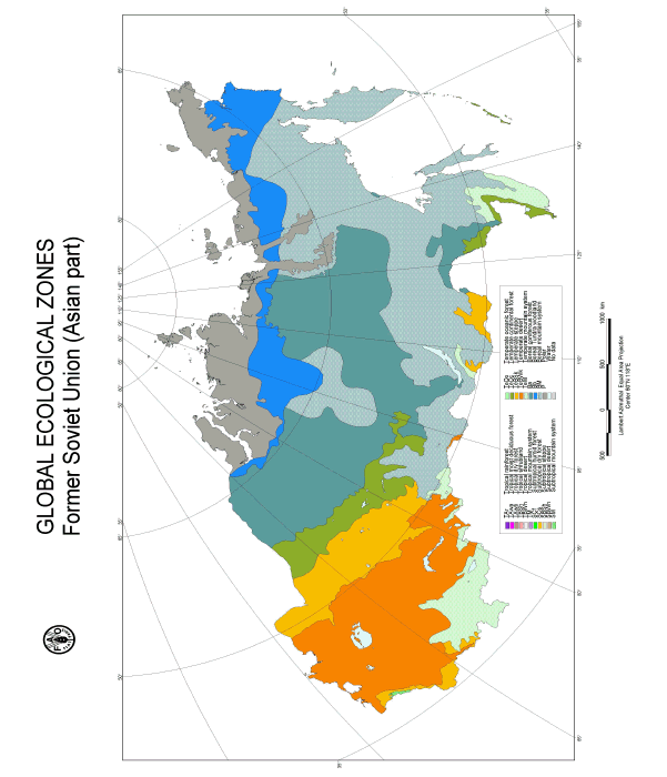
Figure 38. GEZ map of the former Soviet Union (Asian part)
Table 23. Global Ecological Zones of Asian part of FSU
Surface area | |||
Km2 |
% of total land area Region |
% of GEZ worldtotal | |
Subtropical mountain systems |
6 962 |
0.0 |
0.1 |
Temperate oceanic forest |
0 |
0 |
0 |
Temperate continental forest |
761 670 |
4.6 |
10.1 |
Temperate steppe |
1 202 708 |
7.2 |
20.4 |
Temperate desert |
2 321 906 |
14.0 |
43.0 |
Temperate mountain systems |
768 827 |
4.6 |
10.6 |
Boreal coniferous forest |
3 924 347 |
23.6 |
46.4 |
Boreal tundra woodland |
1 296 926 |
7.8 |
32.8 |
Boreal mountain systems |
4 550 130 |
27.4 |
72.2 |
Polar |
1 768 313 |
10.7 |
32.7 |
Total land area |
16 594 827 |
99.9 |
|
This vast geographic region covers the Asian part of the former Soviet Union. The European part, comprising the area west of the Urals, is described under Europe.
This Ecological Zone includes both the polar (arctic) deserts, including islands of the Arctic ocean-Severnaja Zemlja, Novosibirsk islands and northern upland part of the Taimir Peninsula and treeless tundras divided into three latitudinal belts - arctic tundra, northern (typical) tundra and southern (shrub) tundra. Big territories to the east from the Lena River are covered by mountain tundra which occupies plateaus and mountain systems. The southern boundary of the tundra zone is approximately along 67oN in West Siberia, at Yenisey River about 69 oN and toward the east it significantly shifts to the north. In the Lena river basin the southern boundary of tundra is about 71oN and in the Kolyma basin north of 68oN. In basins of Okhotsk and along the Bering Sea, tundras are stretching further south (up to 60oN).
Climate
The climate is extremely harsh. The severity increases from West to East Siberia and is moderated at the Arctic-Pacific coast. The temperature of the coldest month ranges from 23o to -35oC in West, -29o to -40 oC in East Siberia and from -20o to -34 oC in the Beringiiskaja tundra. The average annual temperature has similar character - from -10o to -16 oC. Continuous permafrost covers all the territory. Amount of precipitation is low - basically from 100-250 mm yr-1 (and up to 400 mm in the western part), but everywhere significantly exceeds evaporation and humidity of soils is usually high. Length of growth period (here and below as a number of days with t > 10oC) is from about 0 in the extreme north to 50 days in the south.
Physiography
Arctic country is covered with ice and snow throughout the year or through most of the year. To the south the tundra landscapes are mostly characterized by plain-like topography, abundance of brooks, depressions and marshland. Uplands and plateaus are present in the eastern part of the belt.
Vegetation
In the southern part of the arctic deserts, on land free from ice and snow, occasional sparse vegetation of mosses and lichens is encountered, with a few grass species. Small areas are covered by grass-moss mires. Trees and shrubs are lacking. The tundras are also treeless owing to their marshiness and unfavourable climatic conditions. The northern part of the Ecological Zone is covered by prostrate dwarf shrub-herb-lichen-moss and herb-lichen-moss polygonal spotted tundras; sedge-grass-moss mires cover significant areas. To the south, in the sub-zone of typical tundras, the major vegetation types are presented by hemiprosrate dwarf shrub-lichen-moss, herb-lichen-moss hummock-spotted, tussock and low shrub tundras. Wetlands are basically presented by polygonal herb-dwarf shrub-lichen-moss mires. In the two above sub-zones, occasional low-growing willows (Salix herbacea, S. polaris, S. reptans, S. rotundifolia, S. pulchra) grow among the mosses as well as the creeping dwarf-birch (Betula nana and B. exilis). In the southern tundras, stretching further south, there are low thickets of dwarf birch, many species of willow (Salix lanata, S. hastate, S. pulchra, S. arctica etc.), wild rosemary (Ledum pallustre), bushy alder (Alnus fruticosa) and berry-like undershrubs, including bog bilberry (Vaccinium uliginosum), cowberry (V. vitis idaea), cranberry (V. oxyococcus) etc. The Taimir tundra has the highest biological production among the entire Northern Eurasia polar domain. The green foliage of the shrubs serves as summer fodder for reindeers.
The Boreal domain covers more than 85% of Asian Russia. A distinctive feature of this vast territory is a dominance of evergreen and deciduous cold coniferous forests. Although there is a limited number of major indigenous forest forming tree species (five coniferous species, i.e., pine, spruce, larch, Russian cedar pine and fir, dominate about 80% of the forests of Northern Eurasia), diversity of forest types and habitats is tremendous. The worlds largest continuous larch forests (over 250 million ha) cover a major part of central and eastern Siberia. More than one third of this territory comprises mountains. There is an evident temperature gradient, which defines latitudinal zonality of lowland vegetation - from open woodlands (forest-tundra ecotone) through northern, middle and southern taiga sub-zones to transitional to the temperate domain, mixed forests. Natural disturbances - fire throughout the zone and insects outbreaks, the latter mostly in the sub-zone of southern taiga, - are a major driving force of succession dynamics and structure of forests. A major part of boreal forests is presented by different types of uneven aged forests. Altitudinal zonality in mountains repeats major regularities of latitudinal changes of vegetation and a shift of approximately 200 km northward provides similar vegetation changes as 100 m change in altitude.
The Asian part of the zone is a rather wide belt, stretching in longitudinal direction. Landscapes are mostly presented by the typical transition zone, with vast areas of tundra and bog vegetation, alternated by sparse low productive forests and shrubs. The northern part of the zone, 100 to 250-300 km wide, is a "human-induced treeless belt", where lack of forests is assumed to be a consequence of anthropogenic and natural disturbances, mostly wild fires.
Climate
Climate of the Ecological Zone is under strong impact of continental and partially maritime, arctic atmospheric masses. Only in the extreme east, the impact of arctic maritime climate significantly increases, moderating the severity and continentality of climate. Severity of winter increases from the coast landinward. All territories are under continuous deep and cold permafrost. In West Siberia, in the lower reaches of the Ob River, average annual temperature is from -6o to -8 oC, January 24o to-26 oC, July 13o-14 oC. Growth period 47-57 days, the period with snow cover 235 days, precipitation 320-370 mm. In forest tundra of Central Siberia (between the Yenisey and Lena Rivers), the severity of climate increases: the average annual temperature decreases to -12o to -15 oC, January from 31o to -42oC, July 11o-14 oC. The minimal temperature reaches 58o to -65oC. The growth period is very short, from 35-60 days. Annual precipitation amounts 240-400 mm. Mountain relief in the eastern part causes a high variety of climatic indicators. The average annual temperature is from -4o to -5 oC in coastal regions to 12o to -14 oC in continental regions, January -26o to -34 oC, July - from 13o14 oC. Growth period is short, 58-65 days and annual precipitation ranges from 310 to 550 mm. Throughout the Ecological Zone most of the precipitation falls during the warm period.
Physiography
In the west, West Siberian lowland swamps comprise a major part of the Ecological Zone. To the east from the Yenisey River, the zone occupies a part of North Siberian lowland and northern parts of Putorana plateau and Anabarskoe, which are parts of Middle Siberian upland. To the east of the Lena River, a major part of the territory is mountain, with uplands up to 400-800 m altitude, dissected by deep river valleys. The vast Kolyma lowland between the rivers of Indigirka and Kolyma adjoins the Arctic Ocean coast. The territory is a part of the Pacific belt of mezo-kainozoic plicateness. Carst and soliflucation processes are usual for the Ecological Zone like for all the Asian permafrost territories. Major soil types of the Ecological Zone are presented by tundra - and taiga frozen soils (podburs), humic and peaty soils.
Vegetation
Pretundra open woodland is usually found in lower-lying and better-drained terrain alternated by southern tundras and herb-lichen-moss palsa and herb-sphagnum-hypnum aapa mires. In the southern part of the Ecological Zone, sparse coniferous forests follow the river valleys in narrow belts of several kilometers wide. In most cases, trees are irregular in shape, with crooked boles, one sided flag-like crowns and sometimes a form resembling creeping arboreal plants. The soil cryogenic processes often cause the phenomenon of "tipsy forests". In the West-Siberian forest tundra, the dominant species is Siberian larch (Larix sibirica) with an admixture of Siberian spruce (Picea obovata), which form typical sparse forests with shrubs (Betula nana, Salix phylicifolia, S. dasiclada, S. lapponum) and a green floor of lichens and (green) mosses. In central Siberia, Larix gmelinii is dominant (the boundary between Larix sibirica and L. gmelinii is to the east from the Yenisey River); spruce forms the second canopy layer. The worlds most northern forest islands are described here - a forest massif Ari Mas is growing on an ancient high terrace of the Novaja River, a tributary of the Khatanga River, at 72o30 N. To the east, in basins of Indigirka and Kolyma Rivers, the principal species are Larix gmelini and L. cajanderi. The latter replaces L. gmelinii to the east of the Lena River. A specific feature of the Ecological Zone is the abundance of dwarf pine (Pinus pumila) and bushy willows (Salix udensis, S. schwerin), which exceed in area the "high" forests. Mongolian poplar (Populus suaveolens) and Korean willow (Chosenia arbutifolia) grow in river valleys. The northern tree line goes along the reaches of the Kolyma River to the north of 69oN and to about 65oN in Chukotka, characterized by poplar, Korean willow and bushy alder.
The Ecological Zone of boreal cold coniferous forests covers major areas in Asian Russia. The taiga, divided in three sub-zones, northern, middle and southern taiga, is a major zonal vegetation type. The southern boundary of the southern taiga, the boundary of the Ecological Zone, goes from the interflow of rivers Tobol and Tavda to the line Tomsk-to the north of Krasnoyarsk, at about 57oN. A small island of lowland boreal forests is in the Russian Far East to the north of the Amur River.
Climate
Three major driving forces define climate of boreal West Siberia: solar energy, the Atlantic ocean from the West and the powerful East Siberian winter anticyclone from the east. Major variations of climate are two-dimensional: increase of heat from north to south and increase of continentality from west to east. The climate of the northern part is under influence of atmospheric processes of basically arctic origin. The latitudinal variation of climate is significant. To the south, the low winter temperature contrasts to relatively high summer temperature. The maximum precipitation (on average 500 mm) is in the centre of the plain (about 60o N); to the north and south amount of precipitation is lower. The snow cover plays significant role in West Siberia, defining the depth of frozen soils in winter and determining hydrology in summer.
For the northern taiga sub-zone of West Siberia: the average annual temperature is about -4 oC, January 22o to -24 oC, July 16o-17 oC, growth period 85 days, the period with snow cover 190-200 days, annual precipitation 410-450 mm. Continuous permafrost disappears in the northern taiga sub-zone. To the south, the climate becomes significantly warmer. In the middle taiga the average annual temperature is 1o to -3oC, January -19o to -22 oC, July 17o-18oC, growth period 95-105 days, with snow cover 185-195 days, annual precipitation 410-580 mm. In the southern taiga of West Siberian Plain, between the rivers Irtish and Yenisey, the average annual temperature increases to -0.4o to -1oC, January -18o to -21oC, July 16.5o-18oC, growth period 100-115 days, with snow cover 175-190 days, precipitation 410-550 mm.
Throughout the Ecological Zone, rainfall is concentrated during the growing period or warm season.
To the east of the Yenisy River, continentality of climate and severity of winters significantly increase for the corresponding sub-zones. In the sparse taiga of the east part of Middle Siberian Plateau, climate is extremely continental, with little precipitation, dry spring and severe winter. The average annual temperature is -11o to -13oC, January -38o to 43oC, July 14o-17oC, growth period 63-73 days, with snow cover 228-237 days, precipitation 200-290 mm. The climate of the middle taiga (the basin of the Viljui River and more southern territories) is a little bit warmer: the average annual temperature is -6o to -10oC, January -30o to -36oC, July 15o-19oC, growth period 80-95 days, with snow cover 195-215 days, precipitation from 220-275 mm in the north to 350-500 in the south. A major part of the zone is covered by continuous permafrost, deep (up to 600 m) and cold (-8o to -12oC) to the north, which crucially impacts structure and functioning of forest ecosystems. The melting layer is from 0.2 to 0.5 m on wetlands and up to 0.5-0.8 m on drained sites.
Physiography
The West Siberian lowland plain has a form of an amphitheatre, open to the north. Uplands, plateaus and inclined plains abound in the west, south and east, while lowlands prevail in the centre and the north where altitude does not exceed 150 m. In the north, the relief of the plain has been formed by Pleistocene glaciation, to the south from low hills of Sibirskie Uvali (63oN) - as a result of erosion and accumulative activities of rivers which belong to the basins of Ob and Yenisey Rivers. A major part of the plain is swamp. Soils of bogs are mostly presented by peat transitional moor and peaty-muck humic gleyic types. Drainage is very poor, better to the south and edges of the plain. At drainage sites, podzolic and podzolic-gleys peat and peaty soils are usual. Sod-podzolic, grey forest and humic-podzolic-gleyic soils dominate in the southern taiga. To the east of the Yenisey River the relief of the zone is presented by hilly upland territories, with altitudes up to 250-500 m. They comprise the southern and eastern parts of the Middle Siberian upland, including also Central Tungusskoe and Prilenskoe plateaus. At its eastern edge the zone includes plains along the Lena River, which are bounded by the Verkhojanky range from the east.
Vegetation
Distribution of vegetation is defined by zonality and continentality of climate. Higher humidity in the western part causes a dominance of dark coniferous forests (dominated by spruce, fir) and increasing dryness and continentality determines dominance of light coniferous forests (predominance of larch and also pine to the south) in the eastern part of the zone.
Swamps and marshland dominate the Northern taiga of the West Siberian plain. Forests of the zonal type are confined to well-drained river valleys. They are dominated by Siberian cedar pine (Pinus sibirica), with a mixture of spruce (Picea obovata), birch (Betula pendula), Siberian larch (Larix sibirica) in the north and slow growing fir (Abies sibirica) in the south. Secondary birch forests are extensive. Well developed green mosses cover with patches of Sphagnum and Pleurozium schreberi and lichens is typical for the northern part. The green forest floor is composed of bilberies (Vaccinium vitis idaea and V. mirtillus), different species of Carex, Equisetum. Pine with larch forests grow on sandy soils in this sub-zone; to the north pine disappears and single-species larch forests prevail. In these forests, lichens (Cetraria cocullata, C. nivalis) form a continuous ground cover. Wetlands are represented by raised Sphagnum bogs, either without trees or with a very sparse cover of pine, cedar, spruce and larch.
Watersheds in the middle taiga are covered by different types of raised and transitional bogs. Sparse cedar forests with birch usually grow in valleys. To the south, the share of wetlands significantly decreases. Uplands in middle and southern taiga are covered by cedar-spruce and cedar-spruce-fir forests on podzolic and humic-podzolic-gleyic soils. Towards the south, birch (Betula pendula) and aspen (Populus tremula) forests increase. Pine forests with lichens grow on drained sands.
To the east of the Yenisey River, dark coniferous taiga gives way to light coniferous larch and pine forests. In the northern part, in the basin of the Podkamennaja Tunguska River, larch - pine and pine forests with mosses predominate. Spruce and cedar forests with birch and aspen occur in river valleys. Hummock peat areas cover significant territories. To the south, pine dominates. The most productive Asian pine forests grow in the basin of the Angara River where growing stock volume in best sites can reach up to 500-600 m3 ha-1. Pine and larch forests are accompanied by lichens, mosses, grasses and fern-horse-tail forest types.
To the east, in Central Yakutia, larch is almost the single dominant species. Other species, pine and birch, occupy less than 10% of forested areas. The larch forests usually have an undergrowth of dwarf shrubs (Vaccinium uliginosum, Arctous alpina), the drier with Vacinium vitis-ideae and Dryas crenulata and the wetter with Ledum palustre. Other types include larch with Arctostaphylos uva-ursi, Duschekia fruticosa, mosses, Ledum palustre, Sphagnum on frozen taiga pale soils.
To the north, in the northwest part of Yakutia and partially in Evenkija and Taimir national district, northern taiga larch sparse forests cover about 95% of forested areas. In such forests, bilberry, mosses and lichens, together with Betula exilis and Duschekia fruticosa, form the green forest floor; presence of Arctous erythrocarpa and Limnas stelleri is a typical feature. Dwarf pine (Pinus pumila) cover about 4-5%, while birch is very rare. Small areas of low productive pine forests reach the Arctic circle near Zhigansk along the Lena River. Sparse larch forests are common in the south, on Olenek-Viljui plateau with sparse low canopy layer of Siberian spruce (Picea obovata).
The Asian mountain boreal domain is presented by two main areas - the higher part of Middle Siberian uplands, which we designate as Region 1 and vast mountain territories which occupy the south of Siberia and cover the major part of Yakutia and Far East. Considering the high diversity of vegetation in the latter area, we divide this territory in 5 regions: Region 2 - mountains of southern Siberia, 3 - mountain country from the Baikal lake to coastal Pacific ranges, 4 - the southern-west edge of the Russian continent, including the northern and middle part of Sikhote-Alin, 5 - the huge mountain territories of northeast Russia, from the Lena River including Central Yakutia toward the Korjak upland and 6 - the Pacific zone which includes Kamchatka peninsula, Sakhalin and Kuril islands.
Climate
Climate of this Ecological Zone is extremely diverse and generally severe. Snow cover is usually abundant and perseveres for considerable time of the year. Continuous, deep permafrost predominates. The harshest climate is found in the Middle Siberian uplands (Region 1) and the mountains of northeast Russia (Region 5). Here, mean annual temperatures range from 11oC to 13o, -14oC, with January temperatures as low as 35o to 43oC and minimum temperatures of 50o to -60oC. July temperatures are 13o to 160C and length of growing period in those regions is only 60 to 80 days. Annual rainfall amounts to 200 and 300 mm, predominantly as snow. In other mountain areas, conditions are less severe, particularly with higher minimum (January) temperatures. There is high variation in amount of precipitation; for instance the High West Altai (part of Region 2) receives up to 2000 mm of precipitation, which, together with rather warm conditions, favours growth of dark coniferous forest vegetation. In lower East Altai, part of the same region, precipitation is much less, which favours development of larch forests. The climate of region 3, on average, is typical for the middle taiga sub-zone. Here, average annual rainfall ranges from around 450 mm in the west to around 550 mm in the east.
Physiography
Large impressive mountains border boreal Asia in the south. The Altai-Sajan system includes Altai, Salair, Kuznetsky Ala-Tau, West and East Sajan, Tuva upland of northern-west or sub-latitudinal directions. Baikal mountain country, mountains of the basin of the Baikal lake and Stanovoi range, is mostly oriented in northeast and latitudinal directions. Mountain systems and highlands alternate with low hills and inter-mountain depressions. Altai-Sajan system comprises high mountain ranges with peaks of the Alpine type, e.g. Katunsky range with a peak Belukha-4506 m, middle high mountains and accumulative plains. Vast highlands and mountain ranges with heights up to 2500-3000 m dominate Baikal mountain country. Intermountain plain hollows occupy significant areas at 500-1000 m. Mountains of Southern Siberia are a result of Mesozoic and Cainozoic activities.
Vast mountain territories stretch from the Baikal lake to the east, including ranges around the lake (Khamar Daban, Jabloneviy), Stanovoe and Aldanskoe uplands (nagor'ja) and Stanovoi range (up to 2400 m).
The southeast part of the mountain boreal domain comprises highlands of the basin of the Bureja River to the southeast, including northern and middle part of the Sikhote-Alin. In the north, a specific feature of the relief is a combination of high mountain ranges with deep and often wide valleys. A number of high ranges with peaks up to 1200-2500 m are situated here. The thermal regime of soil is very unfavourable due to thick ground litter (up to 40-50 cm). The extensive range Sikhote-Alin with major mountains up to 800-2000 m stretches along the Pacific coast. Between these highlands, significant lowlands with elevations of 50-100 m are situated along rivers Amur, Ussuri, Amgun' and Uda. Growth conditions correspond to middle taiga in the north and to southern taiga in the south.
The huge mountain country of Central Yakutia stretches to the north, behind the Lena River. It includes Verkhojansky range (up to 2389 m) and Chersky range (Pobeda peak, 3147 m) and Jukagir and Alazeja uplands. High mountains, Suntar-Khajt and Buordakh ranges, are covered by glaciers and everywhere continuous permafrost abounds. To the northeast Kolymskoe and Chukotskoe nagor'ja (uplands) are composed of medium altitude mountains. A plicate mountain system Sikhote-Alin (up to 2077 m) occupies the southeastern edge of Russian Asia. Finally, Korjak nagor'e (upland), Kamchatka, Sakhalin and Kuril islands consist of young geosynclinal belts of the Pacifics.
The central part of Middle Siberian uplands comprises medium altitude Putorana (up to 1701 m) and Anabarsk (905 m) plateaus and to the south, the Siverma and Viljuisk plateaus.
Vegetation
Distribution of forest vegetation, species composition and productivity of forests vary widely over these vast mountain territories. Altitudinal ranges of vegetation belts and forests in particular depend on many factors: geographical location and climate, average heights of mountain systems, exposition of macroslope, etc. While temperature is a major limiting factor in the north, amount of precipitation and air humidity limit distribution of forest altitudinal belts in the south.
Region 1: In the Middle Siberian plateau, forests of the Putorana plateau are the most diverse. Three altitudinal belts are clearly separated here: nothern taiga (forest) belt, sub-alpine and alpine. Larch (Larix gmelini) forests grow up to 750-850 m in the southern part and up to 450-600 m on southern slopes in the north. Small areas of larch, usually as a dwarf form, occur up to 900 m on southern slopes. The relative productive larch forests with admixture of birch and spruce grow in southwest and western parts of the plateau. In the central and eastern parts of the plateau, forests cover only small areas at the mouth of some rivers. Lichens, green mosses, undershrubs, low grasses, grassy-bogs and sphagnum groups of sparse larch forest types occupy a major part of the territory.
Region 2: High productive dark coniferous taiga dominates in West Altai. The altitudinal zonation is as follows: the foothill belt of aspen forests with fir (Abies sibirica) replaces bunchgrass steppes which are situated below; uphill, the belt of fir (chernevaja) taiga (from 400-600 to 800-900 m), with aspen in lower parts and cedar (Pinus sibirica) in upper ones; the next belt consists of typical dark coniferous forests (up to 1400-1500 m), dominated by cedar and fir and with very modest admixture of spruce. The sub-alpine belts (1500-1800 m) are occupied by low productive cedar forests. Undershrubs (Caragana arborescens, C. frutex, Lonicera tatarica, Rosa spp., Spirea media, S. crenata, S. hyperfolia) and high grasses (Stipa pennata, Poa attenuata, etc.) are well developed, in particular in lower altitudinal belts. Meadows dominate the sub-alpine belt, followed higher up by alpine tundra vegetation (Seseli monstrosa, Doronicum altaicum, etc.). Similar altitudinal zonation of vegetation occurs in the Salair range, Kusnetsky Ala-Tau and northern part of East and northern macroslope of West Sajan. The upper forest altitudinal belt (1800-2400 m) is usually formed by cedar-larch forests. Eastern Altai has a well-developed belt of larch forests. Forests of the Tuva region are mostly represented by larch, which cover foothills and middle mountains (up to 1400 m). Cedar forms a narrow belt above the larch forests, usually in the east part of Tuva (up to 1700-1900 m).
Region 3: An absolute dominance of larch is typical for the western part of the region with usually in association with cedar and spruce (Picea obovata) and Pinus pumila in undershrubs. Dwarf pine and alder form a sub-alpine belt. Pine forests grow in river valleys. Towards the east, dark coniferous species do not play any significant role, but pine and birch are common. Rather productive larch and pine forests are found in the east.
Region 4: In the northern part, forest vegetation is expressed by an alternation of larch forests on cold soils and spruce (Picea ajanensis) forests on warmer soils, with admixture of Abies nephrolepis, Betula platyphylla and Pinus sylvestris. Poplar (Populus maximovichi), bird-cherry trees (Padus asiatica and P. maackii) and others are common in the lower belt. Pinus pumila is widely distributed in high mountain areas. To the southeast, spruce (Picea ajanensis) and fir (Abies nephrolepis) with some admixture of Korean cedar pine (Pinus korajemsis) and some broadleaved species comprise the zonal forest vegetation. Korean cedar pine together with spruce, fir and broadleaved species, including Tilia amurensis, different maples, etc., constitute a common forest type. There is a significant admixture of Fraxinus mandzhurica, Ulmus lacinata, Juglands mandzhurica, forming a belt of mixed coniferous broadleaved forests, mostly in river valleys and lower parts of mountains. Pinus korajensis forests decreased considerably during last decades due to insufficient management. Lowlands in lower reaches of the Amur River are covered by spruce and fir forests, like a major part of the forest belt in northern and middle Sikhote- Alin.
Region 5: In the north (Yukagir upland), sparse larch (Larix cajanderi) forests, either single-species or in association with Betula kajanderi, cover extensive areas. Korean willow and popular grow in river valleys. Dwarf pine (Pinus pumila) covers only small area due to high continentality of climate. In the central part, dominated by mountain systems of Vekhojansky and Chersky ranges, the top level is presented by stony deserts, which are replaced by mountain tundra downhill. Further down (1800-1400 m) followed by a sub-alpine belt with Pinus pumila. Low productive sparse larch forests generate a belt from approximately 1400 to 500 m altitude, on southern slopes. Relatively stocked larch forests cover the lower altitudinal belts and river valleys. Wild fires often decrease productivity of larch forests. Four major altitudinal belts are observed to the east, in the coastal zone of the Okhotsk sea, from low to high altitude: 1) a belt of stocked larch forests, on average up to 400-500 m; 2) low productive sparse larch forests with Pinus pumila, from about 400-500 to 700-1200m. Larch sphagnum sparse forests with Vaccinium, Ledum, etc., are common on northern slopes; 3) usually above 700-1000 m to 900-1400 m, the sub-alpine belt dominated by Pinus pumila, which cover here more than 50% of the area and 4) mountain tundra. To the west, on Oimjakon upland, continentality of climate increases significantly. Pinus pumila plays a significant role in the sub-alpine belt where precipitation is higher. Larix cajanderi is a major forest forming species, sometimes with admixture of birch and poplar. A specific feature of this region is the presence of cold steppe cenoses, which are widely distributed in dry lowland along the Jana River.
Region 6: The mild cool and very humid climate of the coastal part of Kamchatka favours a wide distribution of meadow vegetation. Forests are mostly dominated by stone birch (Betula ermani), which forms specific open park forests with strong meadow ground cover. Dwarf pine (Pinus pumila) and bushy alder (Duschekia kamchatika) and grassy-Sphagnum bogs with Myrica tomentosa can be found at the east coast and sub-oceanic raised bogs with Empetrum sibiricum, Myrica tomentosa, Carex middemdorfii at the west coast. In mountain depressions, along the Kamchatka River, bottom and foothills of the depression are covered by larch and, covering small areas, spruce forests. Further up-hill is a belt of park birch forests, followed by vegetation of Pinus pumila and Duschekia kamchatica. Peaks are covered by mountain tundra. The northern part of Sakhalin island is dominated by larch (Larix kurilensis) forests; while Pinus pumila and sparse forests of Betula ermanii occur along the coast and at the altitudinal treeline. Rather productive spruce (Picea ajanensis) and fir (Abies sachalinensis) forests grow on the middle part of the island. Elements of nemoral flora are found in forests of the southern part: Quercus mongolica, Fraxinus mandzhurica and others. Across the island, bamboo brakes (Sasa kurilensis) cover significant areas, in particular in the southern part, as a result of intensive man-induced forest fire.
In Asian Russia, just east of the Urals, this Ecological Zone comprises a relatively narrow belt with a typical transitional character and getting narrower to the east. There are different classifications of this territory in Russian publications - zone of deciduous forests, southern subzone of mixed forests, sub-taiga forests, etc. In the FAO EZ system, the zone includes the northern part of forest steppe. There is also a small island of temperate continental forest along the Amur River in the Russian Far East.
Climate
Climate of the Siberian part of the Ecological Zone is moderately continental. Continentality increases from west to east. For the western part of the zone, from Zaural (Behind-Ural) plain to the Yenisey River the climatic indicators change as follows: annual average temperature decreases from 0.2o to -1.5oC, the mean January temperature from -18o to -20.5oC. Mean July temperatures increases from 17.5o to 18.5o C, growth period 115-120 days, precipitation 360-450 mm. Deep snow, about 45-50 cm, stays for 165-175 days.
Physiography
A major part of the Ecological Zone is on the West Siberian plain. Areas of wetlands are smaller than in the north. Grey forest and sod-podzolic soils are usual for drained sites in the north; dark grey forest soils and different types of transformed chernozems are mostly presented in forest steppe. Peat-boggy and humic boggy soils are presented on bogs. There are usually clay soils on watersheds and sandy soils along rivers.
Vegetation
Birch (Betula pendula) in association with aspen (Populus tremula) constitutes a major forest type. Pine forests, sometimes with larch, grow on sandy soils along rivers. Dark coniferous forests are confined to small areas in the northern part. Birch forests vary from dense, high productive stands with a forest-meadow green floor in the north, to sparse park forests with steppe floor (Calamagrostis arundinaces, Brachipodium pinnatum, Aeropodium podgraria) in the south. In the zone of forest-steppe, islands of birch and aspen forests alternate with grass steppe (Stipa tirsa, S. zalesski, Poa angustifolia, Calamagrostis epigeios, Carex pediformis, Filipendula vulgaris, etc.). Bogs are mostly of the grassy types. To the south, the Ecological Zone includes the northern part of forest steppe - meadow steppes and steppificated meadows in combination with islands of small-leaved forests. In Middle Siberia, the zonal forest types are presented by grassy forest with dominance of pine, sometimes larch and birch and territories of forest steppe.
In the Far East, sub-taiga oak-pine and oak-larch forests (Pinus sylvestris, Larix gmelini, Quercus mongolica, Betula davurica, B. platyphyyla) grow along the Amur River, with a mixture of dark coniferous and broadleaved species (Abies nephrolepis, Picea ajanensis, Tilia amurensis). These mixed forests grade into Amur and Manchurian forest-steppe dominated by Quercus mongolica and Ulmus pumila mixed with Betula davurica. In the undershrubs and green forest floor one finds Arundinella anomala, Filifoloium sibircum, Clematis hexapertala. The share of Corelus heterophylla, Lespedeza bicolor and L. juncea increases to the south.
Climate
Climate of the eastern part of the Ecological Zone (steppes of West Siberia and East Kazakhstan) is under strong influence of continental air of East-Siberian origin during winter, causing stable dry and cold weather. At the western side, impact of marine air coming from the Atlantic is sometimes significant, specifically during summer, as well as some influence of cold arctic air and dry and very warm air from arid regions of Middle Asia. As a result, severe winters and rather hot summers characterize the climate of the Ecological Zone. Major climatic indicators for the western part are: annual average temperature from -1.2o to 0.3oC, January 18o to -20.5 oC, July 19-20oC, growth period 125-135 days, precipitation 250-320 mm, snow depth from 25-45 cm. To the east, the annual average temperature increases to 0.7o to 1.8oC, while precipitation is lower, 210-270 mm. Very low winter temperatures, as low as 45o to -48oC, can occur throughout the Ecological Zone.
Two separated small areas of the zone are in Burjatia and in Dahurija of which the major part is outside Russia. The climate in these regions is continental. Average annual temperature decreases to -1.8o to -3.4 oC, average temperature of January is 23o to -32oC, July 18-20 oC, growth period about 110-115 days, precipitation 290-340 mm. Absolute minimum in winter is 46o to -56oC.
Physiography
The Ecological Zone comprises a belt oriented from west to east, from the Pricaspian lowland, through low hills of the southern Urals and the northern part of the Turan lowland, to uplands of the Kazhakhs melkosopochnik (small hills).
Vegetation
From north to south, the Ecological Zone includes sub-zones of northern (forb-bunchgrass) steppes, middle (dry) steppes and southern (desertified) steppes. Severe winters hinder growth of broadleaves species, which are restricted to patches of natural birch and aspen forests. Small areas are covered by pine. Toward the south, forest areas are dramatically decreasing and a limited number of shrubs occur in the semi-desert part of the zone. The major woody vegetation includes: 1) pine, birch and aspen forests of dry sandy soils; 2) pine, birch and aspen forests of stony sites of the melkosopochnik; and 3) willow and poplar forests of flood-lands along rivers.
The steppe vegetation is composed of Stipa zalesskii, S. capillata, S. lessingiana, S. pennata, Helictotrichon desertorum, Festuca valesiaca, Koeleria cristata, Peucedanum morisonii, Salvia stepposa, Filipendula vulgaris, Artemisia frigida, etc., sometimes with shrubs, including Spirea hyperecifolia, S. crenata, Caragana frutex, C. pumila, C. balchschensis.
In the eastern part of the Ecological Zone, Burjatia and Dahuria, forest patches are formed by birch (Betula platyphylla, B. davurica), pine (Pinus sylvestris) and larch (Larix sibirica and L. dahurica) and in river valleys by Ulmus pumila. Steppe vegetation is of the Mongolian type. In the northern subzone, species include Stipa baicalenis, Leymus chinensis, Festuca lanensis, Clematix hexapetala, Hemerocalis minor, Phlojodicarpus sibiricus. On dry steppes one finds Stipa krylovii, Cleistgenes squarrosa, Koeleria cristata, Agropyron cristatum, Poa botryoides, Artemisia frigida, Carex dariuscula.
Climate
Climate of the Ecological Zone is ruled by continental air under hot conditions. Masses of sea air coming from the Atlantic become dry and hot and practically do not bring any precipitation. In particular the southern desert zone remains very dry. Winter and mostly spring cyclones, formed along the polar front of tropical air at the southern boundary of the Ecological Zone, are a major source of precipitation. Long periods of very high temperature and lack of precipitation generate an extremely dry climate. Severe frosts are usual during winter. Average climatic indicators for the northern desert sub-zone, the northern coast of Caspian Sea, are as follows: annual average temperature 7-8oC, January 10o to -11oC, July 25-28oC, growth period 175 days and precipitation 160-230 mm. For the southern deserts of Turan lowland: annual average temperature 13o to 16oC, January 4 to 0.4 oC, July 30-32 oC, growth period 220 days, precipitation 90-110 mm and practically no rain during summer.
Physiography
The Ecological Zone includes the major part of the very diverse Turan lowland from the Caspian Sea to the mountain systems of Pamir-Altaj and Tien Shan. The lowest locations involve a number of depressions: Karagie (-132 m), Akchakaja (-81 m). Vast lowlands, Juzhno-Karakumskaj, Priaralskaja and Sirdar'inskaja, have elevations less than 200 m. Plains of marine -, alluvial, or arid-denudation origin are major elements of relief, among which there are neogene plateaus with steep ledges (Turgai, Ust-Yurt, Zaunguz, etc.) up to 300-400 m. Brown (semidesert) and brown solonetzic and solonchakous soils, as well as solonchaks and solonetzs are dominant soils of the desert zone. The Ecological Zone is usually divided in two, a northern and southern, or three desert sub-zones.
Vegetation
Existence of woody vegetation here is possible only through additional supply of humidity from soils or on sands. Only xerophytic species can grow under those conditions. The major vegetation types are dwarf semishrub, petrophytic and psammophytic shrub desert vegetation communities, with different species of wormwood (Artemisia larchiana, A. pauciflora, A. arenaria, A. semiarida, A. terrae-albae, A. turanica. A. santolina and many others) and grasses such as Poa balboa, Stipa sareptana, S. lessingiana, S. sareptana. To the southeast, juzgun (Caligonum spp.) and saxaul (Haloxylon aphullum and H. persicum) prevail. Two types of forest associations are present in the desert zone: saxaul and tugai forests. Saxaul forests are mostly formed by white saxaul (Haloxylon persicum), common in sandy deserts, black saxaul (H. apphulum) which grows on saline clay soils and to a much lesser extent by H. ammodendron. Saxaul forests are very specific: there is no shadow inside the forests and the above ground woody biomass does not exceed 20t/ha, usually only around 2-3 t/ha. Tugai forests grow on floodplains of big rivers (Amu Daria, Chu, Ili, Syr Daria, etc.), dominated by different species of willow (Salix spp.), poplar (Populus diversifolia, P. liwinoviana, P. pruinosa), ash (Fraxinus patamopholia) and accompanied by shrubs of the genera Tamarix, Berberis, Hippophae and others.
In the Asian part, the Ecological Zone is basically represented by two isolated regions: a) the mountain systems Pamir-Alai and Tien-Shan with Jungar Alatau and b) the southern regions of Sikhote Alin in the Russian Far East.
Climate
The Pamir-Tien Shan mountain sytem is situated within significant desert areas and is under the impact of dry continental air. Nevertheless, marine air from the Atlantic reaching the system is rather humid in its upper untransformed part and leaves a significant amount of precipitation on windward slopes of the highest mountain ranges. Precipitation in foothills is exclusively generated by winter-spring cyclones. It defines a dry with hot summer climate in lower parts of mountains and a more humid type with increase of elevation. For the northern part of Tien Shan major climatic indicators are: a) at foothill belt of dry feather-grass steppe: average annual temperature 7.3oC, January - 8.8 oC, July 22.2 oC, minimal 36o to -38oC, growth period 173 days, precipitation 300 mm; b) at the altitudinal belt of meadow and spruce forests from the lower to upper boundary of the belt: average annual temperature from 6.8o to 2.6oC; January, from -4.3o to -7.3oC; July, from 18.1o to 12.8 oC; minimal 35 o to -38oC; length of the growth period from 145 to 83 days, precipitation from 840 to 880 mm.
The Southern Sikhote Alin mountain system has a favourable, more moderate climate. Diversity of local climates is high and the warming effect of Japanese sea is significant. On western slopes of Sikhote Alin, in the zone of mixed forests, annual average temperature is 0.4oC, January -23oC, July 20oC, growth period 130 days; precipitation 830 mm, concentrated in summer.
Physiography
Tien-Shan mountains, with Pobedi peak at 7439 m, are surrounded by two deserts: Mujunkum in the north and the Kizil-Kum to the west. The system comprises a number of high ranges, oriented in latitudinal direction. The West Pamir has an extremely rugged relief, with high ranges up to 6000 m oriented from west to east. The East Pamir comprises highlands with elevation up to 6200-6900 m. Trees cannot grow here and some shrubs (Ribes villosum, Berberis kaschgarica, Hippophae rhamnoides) reach here highest for all Central Asia elevations up to 4000-4700 m.
Vegetation
Northern macroslopes of the Middle Asia system are under impact of arctic air, which defines dominance of boreal elements such as aspen, birch and spruce. The foothills are covered by dry feather-grass steppe with xerophytic shrubs in gorges. Above this zone, a wide belt of forb-bunchgrass and meadow steppe alternates with shrubs, generated by the genera Rosa, Crataegus, Rhamnus, etc. and patches of deciduous forest on the more humid sites. This forest is dominated by Populus tianshanica, Malus semenovii, with Juniperus turkestanica and other shrubs in the eundergrowth. The next belt is formed by meadows and meadow steppe with areas of spruce forests (Picea schrenkiana) with a mixture of deciduous species and dense undershrubs. Dry stony slopes are covered by dwarf archa (Juniperus turkestanica). Upward we find Alpine meadows and tipchak steppes. A similar altitudinal succession can be observed on other macroslopes, however usually with a higher presence of thermophilous elements (e.g. Juglands regia). Major types of forests in the Pamirs are broadleaved forests of Platanus orientalis, Jugland regia, Acer turkestanicum, Malus silversii at 1000 to 2400 m altitude. The upper belt is formed by archa (Juniperus seravshanica, J. semiglobosa), which extends from 1800 to 3400 m, different birches (Betula turkestanica, B. pamirica, etc.) and poplar (Populus pamirica). Small forest patches of the latter reach locally up to 3800 m.
The succession of altitudinal vegetation belts in Southern Sikhote-Alin is as follows (from low to high altitude):
broadleaf forests (Quercus mongoliva, Betula davurica);
mixed coniferous-broadleaf forest (Pinus koraiensis, Tilia amurensis, T.mandshurica, Acer mono, A. pseudosibolfianum, Fraxinus fhynchphylla, Actinidia kolomikta, Vitis amurensis);
taiga (Abies nephrolepis, Picea koraiensis, Orlopanax elatus, Clintonia udensis);
open woodland (Betula lanata, Abies nephrolepis, Picea ajanensis, Weigella middendorffiana);
dwarf communities (Microbiota decussata, Syringa wolfii, Pinus pumila);
mountain tundra (Diapensia obovata, Ledum macrophyllum, Cassiope ericoides).
REFERENCES
Abaimov, A.P., Bondarev, A.I., Zyrjanova, O.A. & Shitova S.A. 1997. Polar Forests of Krasnoyarsk Region. Novosibirsk, Nauka, 208 pp. [in Russian]
Btyant, D., Nelsen, D., & Tangley L. 1997. The Last Frontier Forests. Washington, D.C., WRI, 42 pp.
Chertovskoi, V.G., Semenov, B.A. & Zvetkov, V.F. 1987. Pretundra Forests. Moscow, Agropromizdat, 169 pp. [in Russian]
Gaidamaka, E.I., Rosov, N.N. & Shashko, D.I. 1983. Nature-agricultural regionalization and use of lands in the USSR. Moscow, Kolos, 336 pp. [in Russian]
Isachenko, T.I., Karamysheva, Z.V., Ladygina, G.M. & Safronova, I.N. 1990. Map of vegetation of the USSR. Scale 1:4 000 000. Institute of Geography, Moscow, RAS. [in Russian]
Kurnaev, S.F. 1973. Forest vegetation regionalization of the USSR. Moscow, Nauka, 203 pp. [in Russian]
Lavrenko, E.M. & Sochava, V.B. 1956. Vegetation cover of the USSR (Explanatory text to the Geobotanical map of the USSR). Moscow, Academy of Sciences of the USSR, Vol.1, 460 pp, Vol. 2 , 971 pp. [in Russian]
Ogureeva, G.N. (ed.). 1999. Zones and altitudinal zonality types of vegetation of Russia and adjacent territories. Scale 1:8000000. Explanation text and legend of the map. Moscow, Moscow State University, 64 pp. [in Russian]
Stolbovoi, V., Fisher, G., Ovechkin, V.S. & Rozhkova (Kravets), S. 1998. The IIASA-LUC Project Georeferenced Database of the former USSR. Vol. 4: Vegetation, IR-98-114, Laxenbur, Austria, International Institute for Applied Systems Analysis, 25 pp.
Semechkin, I.V., Polikarpov, N.I., Iroshnikov A.I., et al. 1985. Cedar Forests of Siberia. Novosibirsk, Nauka, 278 pp. [in Russian]
Stolbovoi, V. & Nilsson, S. 1999. Forest and temperature Associations of Russia relating to global climate Warming. IR-99-006. Laxenburg, Austria, International Institute for Applied Systems Analysis, 26 pp.
Tseplyaev, V.P. 1965. The forests of the U.S.S.R. Jerusalem, Israel Program for Scientific Translation, 521 pp. and maps.
Utkin, A.I. 1965. Forests of Central Jakutija. Moscow, Nauka, 208 pp. [in Russian]
Zhukov, A.B. (ed). Forests of the USSR. 1966-1970. Moscow, Nauka, Volumes 1-5. [in Russian]
