


by
K.P. Ariyadasa
Deputy Conservator
of forests
Sri Lanka Forest Department
May, 2000
Table of contents
1. Introduction
2. National Forest Policy
2.1 Policy on Management of State Forest Resources
2.2 Policy on Management of Private Forests and Tree Resources
2.3 Policy on Wood and Non-wood Forest Products, Industries and Marketing
2.4 Policy on Institutional Support for Forestry Development
2.5 Policy on Intersectorial Linkages
2.6 Policy on International Forest-related Conventions
3. Forestry Planning
3.1 Natural Forests
3.2 Forest Plantations
3.3 Non-Forest Tree Resources
3.4 Land Use Data
4. Capability of Database to Provide Data Required for Forestry Planning
Sri Lanka lost its forest cover rapidly over past few decades. It is estimated that 80% of the land is covered with dense forest at the beginning of 20th century and this has reduced to mere 23% at present. The rapid decline of forest cover was mainly due to population increase, clearing of forest lands for agricultural schemes and new settlements, shifting cultivation and illegal timber extraction from natural forests.
Forests are the most important natural resources in the country and national level planning is essential for the wise use of this invaluable resource. Unlike in the past forestry activities are no longer confined to the areas officially designated as "forests" nor the managers are only traditional foresters. A comprehensive bio-physical, environmental, socio-political and economic projections need to be considered in forestry planning in present day context. Participatory planning at national, regional, and local levels demands detailed information on may fields. The National Forest Policy approved in 1995 contains the measures required to attain the optimal development of forest resources. It also set the priorities and provides the framework for sustainable development of the resource.
National Forest Policy has three main objectives.
To conserve forest for posterity, with particular regard to bio-diversity, soils, water, and historical, cultural, religious, and aesthetic values
To increase the tee cover and productivity of the forests to meet the needs of present and future generations for forest products and services.
To enhance the contribution of forestry to the welfare of the rural population, and strengthen the national economy, with special attention paid to equity in economic development.
The highest priority of the forest policy is for conservation of remaining natural forests for environmental and socio-cultural reasons while forest products and services have to be supplied mainly from trees outside the natural forests. The third policy objective defines the management strategy the participatory management. By examine the policy on management of specific resource type it is easy to have an idea about the nature and type of information required for the forestry planning process.
2.1 Policy on Management of State Forest Resources
All state forest resources will be brought under sustainable management both in terms of the continued existence of important ecosystems and the flow of forest products services.
The traditional rights, cultural values, and religious beliefs of people living within or adjacent to forest areas will be recognized and respected
The Natural forest will be allocated firstly for conservation, and secondly for regulated multiple use production forestry
For the management and protection of the natural forests and forests plantations, the state will, where appropriate, form partnerships with local people, rural communities and other stakeholders, and introduce appropriate tenurial arrangements.
The establishment and management of industrial forest plantations on the state lands will be entrusted progressively to local people, rural communities, industries and other private bodies, in pace with institutionalizing effective environmental safeguards.
Degraded forest land will be rehabilitated as forest for conservation and multiple-use production, where it is economically and technically feasible, mainly for the benefit of local people.
Planned conversion of forest in to other land uses can take place only in accordance with procedures defined in legislation and with accepted conservation and scientific norms.
2.2 Policy on Management of Private Forests and Tree Resources
Tree growing on homesteads, and other agroforestry, will be promoted as the main strategy to supply wood and other forest products for meeting households and market needs
The establishment, management, and harvesting of industrial forest plantations by local people, communities, industries, and others in the private sector will be promoted
The state will promote tree growing by local people, rural communities, NGOs and other non-state sector bodies for the protection of environmentally sensitive areas
2.3 Policy on Wood and Non-wood Forest Products, Industries and Marketing
Greater responsibility will be given to local people, organized groups, cooperatives, industries, and other private bodies in commercial production, industrial manufacturing and marketing.
Efficient forest product utilization, development of competitive forest industries based on sustainable wood sources, and manufacture of value added products will be promoted.
The state will facilitate the harvesting and transport of forest products grown on private lands.
Effective measures to protect the forest and prevent illegal trade in wood, non-wood forest products and in endangered species of flora and fauna will be instituted.
2.4 Policy on Institutional Support for Forestry Development
The National Forest Policy will be kept up to date and implemented in a participatory and transparent manner.
Legislation will be amended or revised, as necessary, to support the implementation of the policy.
The state will provide full support to the various resource managers for sustainable forestry development, and its institutions will be reorient and strengthened to enable them to accomplish their role.
The state will coordinate, carry out and promote research that pays attention to the requirements of beneficiaries and supports the implementation of the sectorial policy.
NGOs and community based organizations will be supported in their forest based rural development activities.
2.5 Policy on Intersectorial Linkages
The National Forest Policy and other sectorial policies will be kept consistent with each other.
Efficient use of scarce forest products and their substitution by other materials will be promoted.
Nature based tourism will be promoted to the extent that it does not damage the ecosystems and insofar as it provides benefits to the local population.
Urban forests and greenery will be developed and maintained.
The general public and industries will be educated about the importance of forestry, and of conserving biodiversity and protection of watersheds.
2.6 Policy on International Forest-related Conventions
The state will observe international forest-related conventions and principles that have been agreed to by Sri Lanka.
Based on the National Forest Policy the Forestry Sector Master Plan was prepared in 1995. This plan covers a period of 25 years from 1995-2020. The data on overall land use planning along with socio-economic conditions is required for forestry planning in general. Among the different land use categories, comprehensive data on the following land use types are essential for effective forestry planning.
Natural Forests
Forest Plantations
Tree resources outside the forests
Watersheds and catchment areas
Different agencies manage the above resources and the nature and type of data available within these institutions differ according to their intended management goals.
3.1 Natural Forests
All natural forests in the country are managed by two government agencies namely the Forest Department and Department of Wildlife Conservation.
Table 1. Extent of Designated Areas Administered by Forest Department and Department of Wildlife Conservation
National Designated |
No. |
Extent (ha) |
As a % of total Land Area |
Forest Department | |||
Forest Reserve |
177 |
466,335 |
7.1 |
Proposed Reserve |
217 |
589,338 |
8.9 |
National Heritage Wilderness Area |
1 |
11,187 |
0.2 |
Sub Total |
395 |
1,066,910 |
16.1 |
Department of Wildlife Conservation | |||
Jungle Corridor |
1 |
10,360 |
0.2 |
National Park |
12 |
462,448 |
7.0 |
Nature Reserve |
3 |
33,372 |
0.5 |
Sanctuary |
52 |
284,117 |
4.3 |
Strict Nature Reserve |
3 |
31,574 |
0.5 |
Sub Total |
71 |
821,871 |
12.4 |
3.1.1 Natural Forest Database
Forest Department has a comprehensive database on natural forests in the country. There are 3 main electronic databases maintained at the Forest Department.
National Forest Geographic Information System
Environmental Information Management System
Database on Forest Plantations -FORDATA
3.1.2 National Forest Geographic Information System
The National Forest Geographic Information System was developed by the remote sensing unit of the Forest Department in 1992. The main purpose of this system was to prepare new maps of the natural and planted forests using satellite remote sensing techniques.
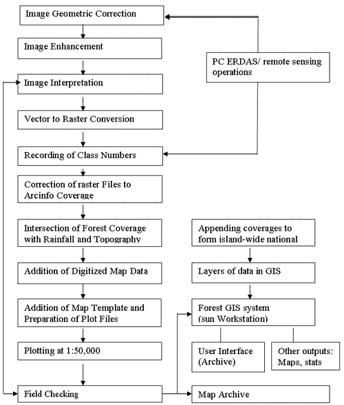
Figure 1. Procedure Used in Forest Map Production
Forest GIS system produces forest cover map of Sri Lanka at 1:50,000 scale with 5 national forest categories and three forest plantation types. Closed canopy forests are further divided in to 4 categories using the altitude and rainfall data.
Table 2. Image Categories of National Forest GIS
Image Categories |
GIS sub-division |
GIS Criteria | |
Rainfall |
Altitude | ||
Closed Canopy Forests |
Lowland Rain Forests |
>2500mm |
<1000M |
Moist Monsoon Forests |
1800-2500mm |
<1000M | |
Dry Monsoon Forests |
<1800 mm |
<1000M | |
Sub Montane Forests |
>1800mm |
>1000M | |
|
Montane Forests |
|||
|
Mangroves |
|||
|
Riverine Dry Forests |
|||
|
Sparse and Open Forests |
|||
|
Conifers |
|||
|
Eucalyptus |
|||
|
Teak |
|||
|
Mahogany |
|||
The archive maps available with the Forest Department and Wildlife Conservation department has been used to digitize the boundaries of forest reserves and protected areas. All the natural forest areas exceeding 20 ha. in extent are shown in the forest cover map.
Map Updating
The first national forest map was produced in 1992 and this map is being updated using the Landsat TM images and air photos obtained during 1997. It is expected to update the national forest map in 7 year intervals.
Access to the Data
As a government department Forest Department is bound to provide information at its disposal to the general public. In case of National Forest GIS all the information except unprocessed digital data are available to any one.
3.1.3 Environmental Information Management System (EIMS)
The Environmental Information Management System is a computerized database management system of information on natural biodiversity, conservation of critical natural habitats, established and proposed conservation areas, traditional uses of forests, and other environmental aspects important for effective decision making on environmental issues.
EIMS contains the data derived from National Conservation Review (NCR) of remaining natural forests of the country. The main emphasis of NCR was the assessment of importance of forests for soil, water and biodiversity conservation. The overriding objective of the NCR is to define a national system of conservation forests in which watersheds important for soil conservation and hydrology are protected, forest biodiversity is fully represented and cultural, economic and social needs are met. All natural forests with an extent of 200 ha. or more included in the NCR except some forests in the Northern and Eastern part of the country which were inaccessible due to security reason. Even forests with less than 200 ha. were included in NCR if these forests known to have high biodiversity. The biodiversity assessment was restricted to woody plants, vertebrates, molluscs and butterflies. Despite such limitations, the NCR is among the most detailed, comprehensive study of its kind undertaken in any tropical country. A total of 1725 plots with the dimension of 100mx5m were inventoried along 310 gradient directed transects in 204 forests during 1991-1996. This survey produced approximately 69,400 records of 1153 woody plant species and 24,000 records of 410 species of selected animal groups. A total of 281 forests were evaluated with respect to their importance for soil and water conservation.
Structure of EIMS
EIMS contains diverse information from list of endangered species to bibliographic references. This information is grouped in to 9 different categories called "EIMS subsystems".
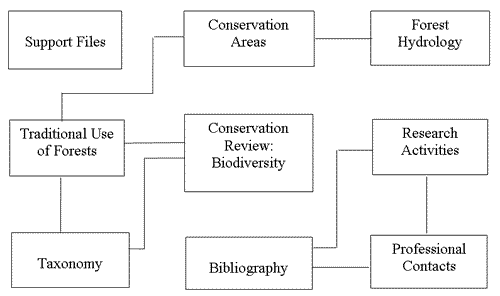
Figure 2. Relational Diagram of the EIMS Subsystems
Table 3. Component of the EIMS
|
EIMS Subsystem |
Content |
|
Conservation Areas |
Information on the established and potential conservation areas within Sri Lanka. The "potential" conservation areas have been defined as land having over 100 ha. of relatively undisturbed vegetation |
|
Conservation Review |
Information generated by the biodiversity survey of natural forests areas. This include plot description including geo reference of the plot, plant and animal data in each plot and data on human resource use |
|
Hydrology |
Information on the hydrological survey of selected conservation areas. There are 27 different data types including mean annual rainfall, erosivity, erodability and mean flood etc. |
|
Taxonomic |
Information on different plant and animal taxa 9 species, sub species, and higher taxa) including parameters such as life form, endemic and threatened status |
|
Traditional Use |
Information generated by the traditional uses of forests survey to identify the traditional uses of primary forests by the local communities and to quantify the extent of these uses in terms of their impact on the forests and importance to the household economy |
|
Research Activities |
Contains one record for every research activity or group of activities carried out by the same institution. Provisions has been made for links with the Bibliographic and Professional Contacts subsystems |
|
Support Files |
Consists of data files and programs important for the general operation of the entire EIMS |
|
Professional Contacts |
The organizations and institutions who are interested in environmental management. It is linked to both research Activities and Bibliographic subsystems |
|
Bibliography |
The documents referenced by the other EIMS subsystem especially Taxonomic and Research Activities subsystems. It also contains information on documents on environmental issues produced locally. |
Updating Information
EIMS provides current information on biodiversity and hydrological importance of natural forests. This provides a benchmark against which future changes can be measured. This is the primary source of information in preparation of 31 management plans for selected conservation forests and each plan contains the measures to be taken to update the information.
Access to Database
Database is located in the Forest Department and access is similar to that of National Forest GIS. Except for the "sensitive" data contain in the database all other data can be used within and outside the department.
3.1.4 Indicative Inventory 1993
Indicative inventory was carried out to assess the timber potential of the natural forests that are allocated for sustained yield management. The data generated from this inventory can also be used for the future management of these forests.
The forest cover map produced by the National Forest GIS was used as the base for the inventory and sampling design. The sampling intensity was decided by the manpower and time available for this inventory. As most of the natural forests were designated for uses other than timber production those forests were not included in this inventory. The following are the forest types that were NOT included in this inventory.
Sparse or Open canopy forests
Mangroves
Forest Plantations
Montane and Sub-Montane Forests
Any forest above 1500m altitude
Areas of natural forests less than 100 ha.
Forests allocated for strict conservation
Wildlife Reserves, Sanctuaries, and National parks
MAB Reserves
Forests in Northern and Eastern part of the country
The total natural forest area of the country and the part that included in this inventory is shown in Table 4
Table 4. Forest Areas by Type and District
|
DISTRICT |
Montane forest |
Sub Montane Forest |
Lowland Rain Forest |
Moist Monsoon Forest |
Dry Monsoon Forest |
Riverine Dry Forest |
Mangrove |
Sparse Forest |
Total |
|
Ampara |
45190 |
69265 |
10160 |
292 |
41760 |
166667 | |||
|
Anuradhapura |
180083 |
0 |
0 |
116693 |
296776 | ||||
|
Badulla |
93 |
3888 |
1577 |
17517 |
3353 |
0 |
0 |
27843 |
54271 |
|
Batticaloa |
13302 |
21770 |
0 |
1421 |
16325 |
52818 | |||
|
Colombo |
1832 |
0 |
0 |
0 |
0 |
36 |
1868 | ||
|
Galle |
18903 |
0 |
0 |
0 |
187 |
1699 |
20789 | ||
|
Gampaha |
273 |
14 |
0 |
0 |
122 |
20 |
429 | ||
|
Hambantota |
220 |
739 |
19169 |
3710 |
539 |
55077 |
79454 | ||
|
Jaffna |
822 |
0 |
260 |
298 |
1380 | ||||
|
Kalutara |
20240 |
0 |
0 |
0 |
70 |
1266 |
21576 | ||
|
Kandy |
935 |
8504 |
14258 |
3545 |
0 |
0 |
0 |
5980 |
33222 |
|
Kegalle |
3655 |
11791 |
0 |
0 |
0 |
0 |
492 |
15938 | |
|
Kilinochchi |
32373 |
0 |
312 |
6042 |
38727 | ||||
|
Kurunegala |
1827 |
8153 |
0 |
0 |
14766 |
24746 | |||
|
Mannar |
111389 |
795 |
1261 |
11762 |
125207 | ||||
|
Matale |
89 |
5314 |
12831 |
41337 |
15237 |
0 |
0 |
9207 |
84015 |
|
Matara |
519 |
16686 |
2174 |
516 |
0 |
6 |
2076 |
21977 | |
|
Moneragala |
65 |
768 |
63558 |
113627 |
4584 |
0 |
52569 |
235171 | |
|
Millaittivu |
153769 |
0 |
463 |
17987 |
172219 | ||||
|
Nuwara Eliya |
1943 |
31078 |
3977 |
2649 |
0 |
0 |
0 |
3273 |
42920 |
|
Polonnaruwa |
47266 |
68093 |
523 |
0 |
22949 |
138831 | |||
|
Puttalam |
79452 |
814 |
2264 |
17104 |
99634 | ||||
|
Ratnapura |
48 |
15816 |
38194 |
4755 |
3545 |
0 |
0 |
4491 |
66849 |
|
Trincomalee |
4 |
110491 |
1826 |
1491 |
17629 |
131441 | |||
|
Vavuniya |
103182 |
0 |
0 |
16504 |
119686 | ||||
|
Totals (ha) |
3108 |
68839 |
141550 |
243877 |
1094289 |
22412 |
8688 |
463848 |
2046611 |
The total area included was approximately 300,000 ha. This areas was divided into 3 strata that effectively represented Wet, Intermediate, and Dry zone natural forests. The sampled strata and subdivision of strata is given below
Table 5. Sample Strata of Indicative Inventory
|
Sample Strata |
Sub-division |
|
Lowland Rain Forests |
Regeneration Forests |
|
High Forests | |
|
Undisturbed or Unlogged Forests | |
|
Dry Monsoon Forests |
Regenerated Chena |
|
Thorny scrub | |
|
Natural Forests | |
|
Moist Monsoon Forests |
Active Chena |
|
Inactive Chena | |
|
Regenerated Chena | |
|
Thorny scrub | |
|
Natural Forests |
The sampling intensity adopted was 0.1% and 0.1 ha. sample units (50mx20m) were used in the survey. These sample units were systematically distributed through out the population. Data required for the volume estimated by species was collected form each sample unit. This enables the production of results for the resources as whole, for each district, for each forest type (strata) and for each forest type in each district. If the forest is large enough to support a larger number of sample units, results specific to that forest block can be produced.
Information Updating
There are no plans as yet to carry out similar inventory. It has been proposed to prepare management plans for the balance area of natural forests during Forest Resource Management Project during 2000-2005 and it is expected to update the information as a part of that exercise.
Access to Database
Database is managed at the Forest Department and access is similar to that of National Forest GIS.
Almost all the forest plantations in the country are managed by the Forest Department. There are about 5000 ha. of plantations mainly Eucalyptus in the privatized tea estates that are managed by the respective plantation companies. Forest Department currently manages nearly 90,000 ha. of forest plantations.
Table 6. Plantations Resource Base
|
Species |
Extent (ha.) |
|
Teak |
38,400 |
|
Conifers |
18,400 |
|
Eucalyptus (Upcountry) |
12,600 |
|
Mahogany |
3,200 |
|
Fuelwood |
16,000 |
|
Others |
10,000 |
Forest Department has prepared management plans for Teak, Mahogany, Eucalyptus and Pine plantations in the country. These management plans were prepared using the inventory data collected over last 10 years and these data is stored in the plantation database called FORDATA.
3.2.1 Database on Plantations
FORDATA is an interactive that is presently used by both the head office and field staff of the Forest Department. This database contains around 4000 records at present. Each record is of a sub-block identified by a combination of Division, Range, Beat, Block, and Sub-block code. It has information on stand parameters such as Species, Age, Mean DBH, Mean BA, Mean Height, Site Index, Stocking etc. It also contains geo reference of each sub-block, Map No., Altitude, and type of Working Circle. Yield prediction functions are also included in FORDATA and it facilitates the development of harvesting schedules by the field staff. A sample FORDATA sub block record is shown in Figure 3.
Information Updating
Data is updated in continuous basis at sub-block level after each field operation.
Access to the Database
This database is for the primary use of Forest Department staff. It is maintained at the head office as well as all the district offices. All the field staff can access the database for retrieving data. FORDATA incorporates security measures that give Forest Department staff access to information, but prevent from making changes to the database, only the staff of the Forest Inventory and Management branch handles the updating of information based on the post operation inventory reports.
|
LOCATION AND NUMBER | |||
|
Division |
NUWARA ELIYA NUWARA ELIYA NUWARA ELIYA II 2 1 | ||
|
Range | |||
|
Beat | |||
|
Block No | |||
|
Sub Block No | |||
|
Reserve | |||
|
SUB-BLOCK DETAILS | |||
|
Area (ha) |
3.5 |
Major Species |
Eucalyptus grandis |
|
Planting Year |
1976 |
Minor Species |
None |
|
Altitude |
1501 and above |
Slope in degree |
0 |
|
MAP DETAILS |
|||
|
20,000 Map Sheet |
354 |
10000 Map Sheet |
69/1 |
|
Easting Grid Ref |
202200 |
Northing Grid Ref |
195700 |
|
LAST INVENTORY | |||
|
Year |
1992 |
Mean Height (m) |
|
|
DBH(cm) |
26 |
Dominant Height(m) |
|
|
Basal Area (m2/ha) |
31 |
Height Index |
|
|
Stocking (sph) |
505 |
Height index base age is 30 for Eucalyptus grandis | |
|
MANAGEMENT | |||
|
Working circle |
Timber |
Percent Damage |
0 |
|
Next Operation |
CT |
Last Operation |
Not known |
|
Year |
1997 |
Year |
0 |
|
Age at next operation |
21 |
||
|
Crop Details per Hectare at Next harvesting Operation |
No. of stems/ha (sph) |
Mean DBH (cm) |
Mean Ht. (m) |
Basal Are/ha (m2/ha) |
*Total Volume/ha (m3/ha) |
**Timber Vol/ha (m3/ha) |
|
Main crop before thinning |
505 |
30 |
28 |
36 |
||
|
Removals |
171 |
25 |
25 |
8 |
77 |
32 |
Removals per Sub-Block at Next Harvesting Operation
Number of stems: 599 Total Volume(m3): 270 Timber Volume(m3): 112
*Volume for Teak are overbark, for all other species volumes are underbark
** Timber Volumes are to a top diameter limit of 20 cm overbark
Figure 3: A sample of FORDATA Sub-block Record
3.3 Non-Forest Tree Resources
It is estimated that nearly 80% of nation's fuelwood requirement and about 70% of timber requirement is obtained from non-forest tree resources in Sri Lanka. Home Gardens Rubber and Coconut plantations, shade trees in tea estates, avenue planting are the main non forest tree resource. Home gardens are the principle source of wood and non-wood forest products which account for nearly 41% of the industrial and construction timber needs of the country.
3.3.1 Home Gardens
The area under home gardens has been estimated by the National Forest GIS. However, there are some limitations in this assessment as it is sometime difficult to differentiate other closed canopy forest type from home gardens. This is especially true in the well grown wet zone home gardens. The technique used in this case is to identify the total closed canopy area and subtract the known forest types to obtain the area of home gardens. Nevertheless, National Forest GIS is very useful in estimating the extent of home gardens in the country.
In 1995, an islandwide assessment of home gardens was carried out to assess the stocking and species composition. The data was collected at Grama Niladhari Level (which is the smallest administrative unit of Sri Lanka comprising only 300 families) after visiting each and every home garden. Most of the tree species found in home gardens are multipurpose species and in this assessment trees were classified in to 3 categories; timber, timber and food, and food only. All the trees larger than 30 cm girth were enumerated species wise and data has been stored in a database. This database is maintained at the Forest Department head quarters.
3.3.2 Rubber Plantations
There are about 158,000 ha of rubber plantations in the country and at the end of tapping period rubber wood is used for timber. The Rubber Development Department is maintained a database on rubber plantations and it contains data on total extent, extent replanted, extent of new planting, latex production, and export earnings. Though the timber volume is not directly entered in to the database this can be calculated with the available data. This database is maintained at the Rubber Development Department and the data is updated annually.
3.3.3 Coconut Plantations
Coconut is a major source of construction timber in the country and there are about 439,000 ha. of coconut plantations in the country at present. Data on coconut plantations are available with Coconut Cultivation Board and Coconut Research Institute. The total extent of coconut, extent of new planting, extent of under planting, extent of replanting, production of different coconut products, and export earnings are available in the database maintained by the above two institutions.
3.3.4 Trees in Tea Estates
Tea estates have both shade trees and timber and fuelwood lots. There are about 5000 ha. of timber and fuelwood plantations in tea estates. These tea estates are managed by 23 Plantations Companies and each company has developed a 5 year working plan for extraction and replanting of timber and fuelwood from the plantations under their control. They are now in the process of preparing management plans for these timber and fuelwood lots. All the stand parameters are available in these plans and respective companies manage database pertaining to plantations under their control.
3.4 Land Use Data
Land use data of the country are available with two main institutions namely Survey Department and Land Use Policy Planning Division of the Agriculture and Lands Ministry.
3.4.1 Survey Department
Survey department is responsible for producing general purpose and land use map of the whole country. The earliest map series is the 1:63000 base maps. Then it produced 1:50000 land use map for the whole country. These maps include the following land use categories.
Table 6. Main Landuse Categories of the Land Use Maps produced by the Survey Department
|
Main Category |
Sub Category I |
Sub Category II |
|
Urban Land |
Built-up Land |
|
|
Associated Non Agricultural Lands |
||
|
Agricultural Land |
Homesteads |
|
|
Tree and Other Perennial Crops |
Tea | |
|
Rubber | ||
|
Coconut | ||
|
Mixed Tree and Other Perennial Crops | ||
|
Cropland |
Paddy | |
|
Sparsely Used Crop Land | ||
|
Other Crop Land | ||
|
Forest Land |
Natural Forest |
Dense Forest |
|
Open Forest | ||
|
Forest Plantations |
||
|
Range Land |
Scrub Land |
|
|
Water |
||
|
Barren Land |
Survey Department also produces 1:10000 scale land use map with mote detailed land use categories Survey Department also has a remote sensing unit that contains satellite imagery and air photos that used in map preparation.
3.4.2 Land Use Policy Planning Division
Land Use Policy Planning Division has country wide land use data and this data is being regularly updated at field level. Land Use Categories are similar to that of land use maps produced by the Survey Department. Data updating is carried out at Grama Niladhari Division level. Base maps for data update is prepared using the current air photos 1:20000 maps. The data is not yet available electronically as they have obtained GIS facilities recently. The type of data available with the Land Use Policy Planning Division is shown in Table 7.
The National Forest Policy and the Forestry Sector Master Plan has all the directives for future forestry planning. As mentioned before natural forests of the country would be firstly allocated for conservation and secondly for multiple-use management. There is a moratorium of logging in natural forests since 1988. The present Forest Policy does not advocate the use of natural forests for timber production. Therefore the main function of natural forests is either conservation or producing non-wood forest products. All natural forests have been classified to 5 categories depending on their management objectives.
Table 8. New Forest Classification based on management Objectives
|
Forest Category |
Management Objectives |
|
Class I |
Natural forests strictly conserved for bio-diversity, soil, water, historical, cultural and religious purposes. Research and controlled visitation allowed |
|
Class II |
Natural forests, forest plantations conserved for bio-diversity, soil and water. Non-extractives uses are allowed |
|
Class III |
Large areas of natural forests and forest plantations allocated for multiple use management by the state with the assistance of local communities |
|
Class IV |
Small areas of natural forests and forest plantations adjacent to communities allocated for multiple use management. Managed by the local communities with the state assistance |
|
Class V |
State or other land registered with Conservator of Forests and managed for agroforestry |
Home gardens and other tree resources outside the forests would be the main source of providing fuelwood and industrial timber in future.
The following table summarizes the capability of current database in providing information necessary for present and future forestry planning.
|
Forest Policy Objective |
Resource Involved |
Database Available |
|
To conserve forest for posterity, with particular regard to bio-diversity, soils, water, and historical, cultural, religious and aesthetic values |
Class I and Class II natural forests |
National Forest GIS Environmental Information Management System (EIMS) Management Plans |
|
To increase the tree cover and productivity of the forests to meet the needs of present and future generations for forest products and services |
Forest Plantations, Class II & III forests, Home Gardens, Rubber, Coconut, Tea and other tree resources outside the forests |
National Forest GIS FORDATA Database of Coconut Cultivation Board, Rubber Development Department, and Plantation Companies Home garden database Indicative Inventory |
|
To enhance the contribution of forestry to the welfare of the rural population, and strengthen the national economy, with special attention paid to equity in economic development |
Class III & IV forests |
National Forest GIS EIMS |
Though there are some limitations the present database is quite sufficient to provide information needed for present and future forest planning.
by
Peter
Holmgren
Director
Country Capacity Building Project, FAO
May,
2000
1. Background
2. World Forest Survey - basic concepts
2.1 Objectives
2.2 Design
3. Implementation
4. Ongoing activities
4.1 Expert consultations
4.2 Methodology development
4.3 Pilot field surveys
5. Conclusion
Despite the efforts during FRA 2000 to compile existing knowledge about forests and forestry, it is clear that many information gaps remain. Furthermore, comparing information between countries is difficult due to variations in definitions or assessment methodologies. Finally, it is very rare that countries have systematic surveys that include assessment of basic parameters for the many disciplines in forestry. As a result, international forestry process will have to (continue to) rely on relatively unprecise and superficial information for their analyses.
There is also an obvious need to strengthen the capacity for forest assessments, knowledge management and policy development in many countries. Table 1 reveals that only 22 out of 137 developing countries have a repeated National Forest Inventory (NFI).
Table 1. Developing countries having carried out National Forest Inventories (NFI) at national or local levels
|
Region |
Number of Countries |
Number of countries | ||||
|
Without NFI |
Partial NFI |
National Forest Inventory | ||||
|
Repeated |
Single shot | |||||
|
After 1990 |
Before 1990 | |||||
|
French Speaking Africa |
31 |
7 |
10 |
0 |
8 |
6 |
|
English Speaking Africa |
25 |
6 |
5 |
8 |
4 |
4 |
|
Near East |
13 |
11 |
0 |
2 |
0 |
0 |
|
Asia & Oceania |
22 |
1 |
2 |
3 |
13 |
3 |
|
Latin America |
17 |
3 |
14 |
4 |
6 |
4 |
|
Caribbean |
29 |
2* |
5 |
12 |
17 | |
|
Totals |
137 |
28 |
33 |
22 |
43 |
34 |
Note (* ): Asia: here referring to 22 countries in the sub-regions South Asia, Continental SE Asia, Insular SE Asia and East Asia.
To address the above, the Forest Resources Assessment Programme of FAO is in the process of developing a World Forest Survey (WFS).
The WFS will be founded on in-situ observations at a large number of systematically sampled plots with known statistical representativity. The WFS will include assessment of the biological properties and trends of forests, woodlands and trees outside forests; as well as socio-economic factors affecting the land use. Implementation will rely on participation of national institutions and local people, and will include a large element of training and capacity building.
2.1 Objectives
to meet the need for objective and qualitative forestry information for a broad range of subjects, on the international level;
to build capacity for national forest inventories, knowledge management an forest policy development.
The design of the WFS will resemble the design of National Forest Inventories in that a systematic sample of plots will be done throughout the studied area (ie the entire world). The sample will tentatively be made on a country-wise basis, in order to (a) tie in to existing NFI's, and (b) vary the sampling intensity according to the size of the country.
The sample plots should tentatively be of the same size globally, preliminarily set to 1 km2.
The first sampling phase will distribute the sampling plots over the country. Depending on the characteristics of the country, existing NFI designs, existing map grids and logistical concerns, this may be done with different degrees of clustering.
When distributed, all primary sampling plots will be mapped with respect to current land use and/or land cover, using a globally defined (by FAO) classification system. This would typically be done using remote sensing techniques, assisted by other available geographic information, but without field checks. The result would be large scale maps that show the distribution of land use/land cover classes within each plot.
The second sampling phase will determine which sample plots to be visited in the field. All plots will first be stratified using the distribution of land use/land cover classes from the first phase. For example, the proportion of forest within the sample plot can be used to determine strata and allow for a varying sampling intensity between strata (Figures 1 and 2). Note that the stratification boundary and the sampling intensity should be allowed to vary between countries.
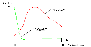
Figure 1. Illustration of possible frequency distributions of plots, by proportion of forest cover within the plots, in different countries.
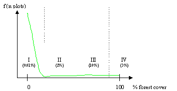
Figure 2. Illustration of possible stratum definitions (I-IV) with varying sample intensities.
Field work shall be carried out in each of the sampled plots in the second phase and it involves (a) a verification and correction of the first phase mapping of the plot (this will also serve as calibration of all first phase plots as to land use/land cover), (b) measurement and estimations of the current status and trends of forests, other wooded land and trees outside forests, (c) interviews to establish how the land is currently used, which changes have been made recently, and which factors (demand and supply) are significantly affecting future management, (d) background research to determine eg legal status of the land. The implementation of the WFS will likely include a set of globally defined field variables, as well as variables adjusted to the local (national/regional) needs.
The implementation of a WFS will rely on
- international acceptance;
- close collaboration with national institutions and professionals;
- a strong coordinating function by FAO;
- delegating the field work component to countries;
- funding from donor agencies to complement national resources where needed.
It is anticipated that FAO takes a lead role in designing the WFS as well as coordinating the sampling procedures. FAO should also provide a ata warehouse for the survey data.
4.1 Expert consultations
FRA has established an international group of leading experts to guide the completion of FRA 2000 and the devlopment of the World Forest Survey.
FRA is currently working on a preliminary overall design and rationale for the WFS. The report will be finished by June 2000.
Pilot field surveys have been carried out in Thailand in April 2000 and are planned for aditional countries. The findings show that the approach is feasible and the forthcoming report will give recommendations for future implementation.
The World Forest Survey concept has been met with enthusiasm from the international forestry community, but also skepticism as to the possibilities to implement it, and to provide funding. The continued development of a WFS will require careful consideration of design options, thorough development of the field work component. Most importantly, the concept must be accepted and endorsed in international forestry fora - particularly the FAO Committee on Forestry that can give a mandate on behalf of FAO's member countries to develop a WFS.
by
Peter
Holmgren
Director,
Country Capacity
Building Project, FAO
May, 2000
1. Background
2. Exercise
2. Findings
3. Conclusions
The Global Forest Resources Assessment 2000 (FRA 2000) has adopted a methodology for forest cover change estimates on national level. The methodology was proposed by an Expert Consultation held in Rome 6-10 March 2000. It suggests that:
- statistical modelling of the type used in FRA 90 should be avoided since the reference data are poor and knowledge of underlying factors of forest change is insufficient. The model type also results in too generalised results, not taking into consideration national variations;
- The estimations should be based on actual observations, i.e. documented forest inventories should be used to calculate change observations, including also historical surveys.
- An expert panel should be composed to evaluate available forest cover change observations. Where several observations exist, the experts shall select the assumed best one, or put weights on the most credible observations. Where no primary observations exist, the experts shall instead use secondary statements on the forest cover change rate.
In the Thimpu workshop, an exercise was held with the seven project countries. Each country delegation was assumed to constitute an expert panel for their own country, and the avaliable time series of forest cover observations was distributed. After a short discussion, the delegations were asked to:
1. State the "official perception" of forest cover change in their country;
2. State whether the available time series is useful for estimating forest cover change.
It should be noted that the exercise was done in a short time and that the results are not authoritative. The exercise was made as a test of the methodology suggested by the Expert Consultation.
|
Country |
"Official perception" (2000) |
Time series useful? |
Comments/other data available |
|
India |
Slight increase (but decrease in some states), decrease of forest cover has been arrested |
Yes |
|
|
Bhutan |
Increase over past 20-25 years |
Yes, similar technique (although different agencies implemente the surveys) |
Data in handout not correct/complete? |
|
Nepal |
Decrease of forest cover arrested in middle hills. Decrease persists in the Terai |
No. Scale, definitions and geounits different. |
|
|
Myanmar |
High rate of decrease (increase of shifting cultivation + current agriculture development trend for conversion) |
Scale differences make comparisons difficult. (but 1955-1997 have same scale) |
Estimate reliable for >40% crown cover |
|
Bangladesh |
Decreasing - conversion of forest to agriculture land |
No. Actual change smaller than time series indicate |
|
|
Pakistan |
Increase, figures being compiled |
Under development. In general difficult to compare reports over time |
|
|
Sri Lanka |
Decrease of dense natural forest, but total figure (including plantations) may not be negative |
Yes for dense forest |
Figures in handout refer to dense forest. Probably different figures if FAO definitions are considered |
The results from exercise suggests that the expert panel model can work well, and that the additional knowledge provided by the experts gave a good insight in the change processes. It is also evident that existing time series can be useless because of changing definitions or methodology in the national assessments. The exercise also suggests that the current change rate in the project countries is far less than in 1990.
