![]()
![]()
![]()
A fundamental precept in the formulation of the methodology of this study has been that qualitative and quantitative information on tropical forest resources is at the same time abundant, scattered and diverse. Each of these qualifications requires consideration. The first one may appear paradoxical: many persons indeed think that relevant information is scarce. However, if they had enough time to search for it, they would find, on the contrary, that it exists in abundance.
The main reason why these data are difficult to obtain relates to the second aspect mentioned, that is their dispersion. There are data not only in the national and international forestry organizations but also in a large number of institutes such as survey departments (and remote sensing centres), agricultural statistics services, colonization and land-use institutes, universities and research organizations in the concerned countries or in developed countries, consulting firms etc. In this respect many thematic mapping studies were carried out at regional, national and subnational levels, in the 70's thanks to the use of remote sensing techniques (Landsat satellite and side looking airborne radar imagery, small-scale aerial photographs). The following examples can be quoted as among the most important in tropical Africa: vegetation maps drawn by the FAO/UNEP Pilot Project on Tropical Forest Cover Monitoring in Benin, Cameroon and Togo, the vegetation map at 1/250 000 for the whole of Nigeria carried out from interpretation of the radar coverage (NIRAD project), the forest map of Mozambique at 1/1 000 000 scale drawn by the UNDP/FAO/Mozambique Forestry and Forest Industries Development Project using Landsat imagery, and the vegetation and landuse map at 1/500 000 scale of the UNDP/FAO/Sierra Leone Land-Use Project, using small-scale false colour aerial photography. Within the framework of this project a certain number of institutions were visited, discussions were held with experts and important correspondence was maintained with many others. It has not been possible, of course, to visit or contact the very large number of national institutions which could have been in a position to provide some useful information, in order to resolve contradictions in the vailable data, and correct erroneous interpretations found in the documents. It is important, however, to underline the fact that a large part of the project activities consisted of collecting as many as possible of the relevant data scattered around the world.
The third characteristic of this wealth of information, is its diversity which can be inspected from at least three different angles:
with regard to the subject matter, which is often not only restricted to forestry: data concerning deforestation are mainly of socio-economic character (distribution and growth of agricultural population, types and pattern of cultivation, internal population migrations, fiscal and other incentives for forest clearing, colonization programmes, development of infrastructure and improvement of accessibility, etc.). Phytogeographic and ecological information and maps are also of essential importance to classify forests according to their production potential. Laws and regulations in the field of natural conservation, indicate the forest areas unproductive for legal reasons, etc.;
with regard to the level or scale of information: it is easier to bring forest resource data up-to-date when forest inventories, reconnaissance surveys and maps have been carried out at national or subnational levels. However, a large amount of information can be found in studies at lower levels (province, district, investment zone, watershed). Although, in many instances, a simple quantitative extrapolation is not feasible, these data are always useful to check corresponding information at national level, to compare situations from one country to the other, or, at least, provide examples to illustrate particular situations and issues (deforestation, degradation, survival and success of plantations, etc.). These local studies are the most numerous and contain the largest amount of useful information. For instance, a very large number of forest inventories have been carried out in Gabon during the last 30 years and the combined interpretation of their results allows for a fairly precise estimation of gross and net commercial timber volumes for the whole country. However, it is often difficult to obtain these local studies because they have been published in a very small number of copies and are not quoted in most bibliographies (University theses for instance), or because they are not known by foresters since they do not deal strictly with forestry matters (studies on sociology, population, agriculture, etc.);
lastly, with regard to the reliability and accuracy of data: all documents on forest resources are obviously of different value and there are many crude assessments and dangerous extrapolations which must be considered with caution. Often absolete information is used again and again by documents, disregarding changes which have occurred in the meantime. It is of the utmost importance to trace out these deficiencies in the data, by means of checks against other sources.
This study has consisted mainly in the selection, organization, compilation and interpretation of this abundant and diverse mass of information using a single framework of classifications and concepts for the 76 tropical countries studies (see section 2). However, in some countries, reliable base-line data on the areas of woody vegetation which could have been used for subsequent up-dating, did not exist at national level. In other countries the project was confronted with two or more sets of area information which could not be matched. In these cases it was decided to interpret available satellite imagery (of the years 1972 – 1976) to check and possibly correct area estimates obtained in a first phase (see section 3). For all countries it has been necessary to up-date the information at the end of 1980 on the basis of the trends observed in the last years and to project the situation at the end of 1985, on the basis of an estimation of the trends in the next 5 years (see section 4).
The value and usefulness of any forest resources assessment study depends, to a large part, on the concepts and classifications used. These must have several characteristics which are not necessarily compatible. In particular they must be:
in accordance with the study objectives;
defined with precision and without ambiguity;
adapted to the type of items surveyed;
matched as closely as possible to the needs of the most important users;
compatible with concepts and classifications already in use in the tropics;
and, last but not least, applied uniformly to the three main tropical regions in order to obtain a consistent picture for the whole tropical world.
In addition to the above conditions, the concepts and classifications of the study must be compatible with those already used in the former FAO World Forest Inventory reports for purposes of comparison and consistency. All these conditions can be fulfilled if one adopts forestry concepts currently in use and classifications which are not too detailed.
2.1 Concepts and classifications of natural woody vegetation
2.1.1 A large number of systems of tropical vegetation classification already exist, using various criteria (ecological, physiognomic, physiographic) at both national and regional levels. In this latter category the following classifications can be identified for tropical Africa:
the so-called Yangambi classification, elaborated during a meeting of experts on phytogeography organized in 1956 under the sponsorship of the Commission for Technical Cooperation in Africa South of Sahara: the agreement reached on the definition of African vegetation types allowed for the preparation of the “Vegetation Map of Africa South of the Tropic of Cancer” at 1/10.000,000 scale published on behalf of l'“Association pour l'Etude Taxonomique de la Flore d'Afrique Tropicale” with the assistance of Unesco;
the classification designed by Professor F. White for a second version of this latter map, prepared for Unesco and which should be published in 1981;
the classification by J. Schmithüsen in his “Atlas zur Biogeographie” covering the whole world.
Vegetation classification at national level are many. They have been used in this study for those countries where there was a corresponding map. As it has already been mentioned in chapter 1 a new generation of vegetation classifications and maps has emerged in the last ten years using classification based on the interpretation of satellite and radar imagery. Classification criteria and categories differ widely not only from one country to another but also within the same country.
2.1.2 When deciding on the forest vegetation classification to be used in this study, great care has been exercised to make it compatible with the Unesco one because of the useful aspects of this latter i.e.:
it applies to the whole world while most of the others are limited to one region only;
it is possibly the first collective and international attempt at a global vegetation classification (while each of the others have been elaborated by a single specialist or a national institute);
it contains a certain number of most important distinctions for forest resources management, such as: separation between tree and shrub formations, separation between more or less closed tree formations on one side and grasslands with a tree synusia on the other side. This latter distinction is essential in tropical countries since the mixed forest-grassland formations play a most important role for grazing and are prone to fires.
2.1.3 In addition to the distinctions mentioned above (tree/shrub and closed forest/mixed forest-grassland formation) there exists other essential classification criteria for woody vegetation formations both from the productive and environmental viewpoints, such as:
distinction between predominantly broadleaved forest and predominantly coniferous forests;
separation between forests which have not been disturbed recently (virgin or primary) and manipulated forests: forests clearfelled and later on provisionally abandoned by shifting cultivation (“forest fallow”), forest degraded by overgrazing and fire, logged over forests;
distinction between productive and unproductive forests using the criterion of industrial wood production, and separation of these latter between those which are unproductive for physical reasons and those which are so for legal reasons (national parks, integral reserves).
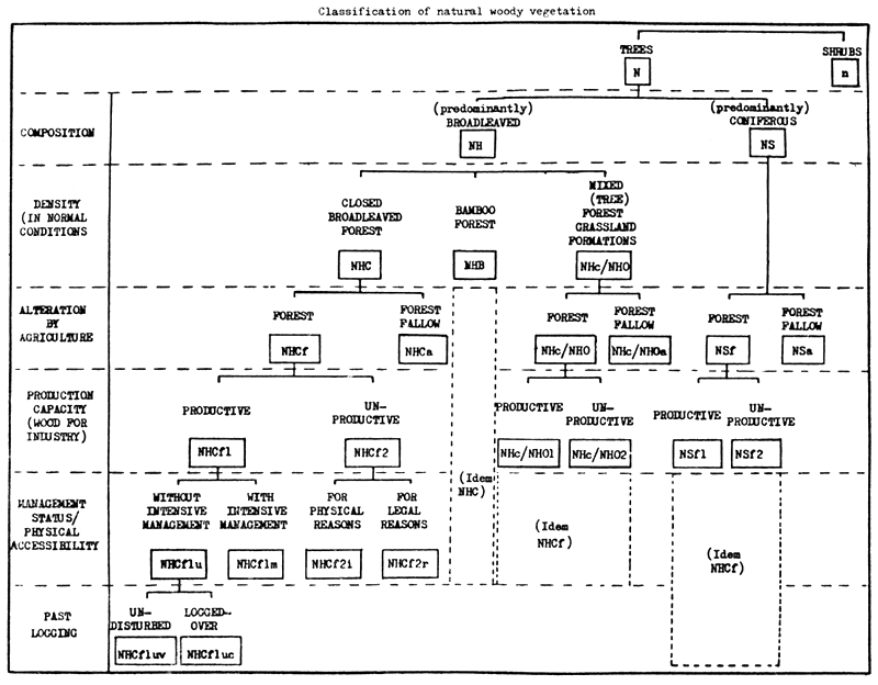
The simultaneous use of all these criteria provides a large number of classes. Some of these classes are not important. Others cannot be identified from the interpreted documents and images and their areas and characteristics cannot therefore be determined. The classification which has been finally adopted is limited to the most useful categories. The following chart presents this classification with the corresponding criteria. The various categories are described in detail below.
2.1.4 Classification of natural woody vegetation (N/n)
The only vegetation types which are considered are those for which woody elements cover more than 10% of the ground. Though it is often difficult if not impossible to estimate this percentage from the descriptions and this percentage is not always used in the classifications, it has been selected as the limit between the types in which the woody elements constitute actually a community and those where they are scattered or (in lines) in landscapes with a non-woody vegetation or without any other vegetation.
The word “woody” is used although the trees of some monocotyledons do not contain “wood” in the usual meaning of the word.
The adjective “natural” is used only in relation with plantations which can be considered as a purely artificial vegetation (see below section 2.2). This does not mean at all that there is no human or, more generally, biotic interference. On the contrary, a significant proportion varying with countries of “natural vegetation” corresponds indeed to degradation stages (after fires, clearings by shifting cultivation, overexploitation for wood, grazing) or reconstitution stages after degradation, or to forests disturbed by logging, with or without management.
N stands for any vegetation type of which the dominant woody element is the tree. The definition of a tree is the one given by the book “Terminology of Forest Science, Technology, Practice and Products”, viz. “a woody perennial plant typically large and with a single well defined stem carrying a more or less definite crown” (height more than 7 metres for mature trees).
n corresponds to any vegetation type the main woody elements of which are shrubs of more than 50cm and less than 7 metres high1.
NH corresponds to types with predominance of trees of broadleaved species (angiosperms) dicotyledons or monocotyledons (e.g. palms, rattans). Predominance is characterised by a proportion of more than 50% of the crown cover.
NS corresponds to types with predominance of trees of coniferous species (gymnosperms). Coniferous species for instance of genus Podocarpus are often present in mixed tropical forests of medium and high mountains, without being predominant. As a result no significant forest area has been classified as NS in some countries in spite of the occurrence of coniferous species.
NHC stands for closed broadleaved forests, i.e. those which, when not recently cleared by shifting agriculture or heavily exploited, cover with their various storeys and undergrowth, a high proportion of the ground and do not have a continuous dense grass layer allowing grazing and spreading of fires. They are often, but not always, multistoreyed. They may be evergreen, semi-deciduous or deciduous, wet, moist or dry;
NHc/NHO corresponds to mixed broadleaved forest-grassland formations with a continuous dense grass layer in which the tree synusia cover more than 10% (e.g. various forms of “cerrado” and “chaco” in America, tree and wooded savannas and woodlands in Africa). This division between closed forests and mixed formations is more of ecological than physiognomic type and is not characterised necessarily by a crown cover percentage, since, for instance, trees of some woodlands cover the ground completely like closed forests.
A similar distinction has not been introduced for predominantly coniferous forests (NS) since it has not the same ecological importance and is difficult, if not impossible, to use.
NHCf (or NSf) corresponds to stands of closed broadleaved forest (or coniferous forest) which have not been cleared (for agriculture mainly) in a recent past (i.e. during the last 20 to 30 years). These forests are either managed or unmanaged forests, primary or in an advanced stage of reconstitution after having been cleared at least 60 to 80 years ago (old secondary forests). These forests may have been logged-over once or more times, having kept their characteristics of forest stands, possibly with modified structure and composition through in particular impoverishment in timber species (logging is accounted for in a subdivision of this category - see below).
NHCa (or NSa), or “forest fallow”, stands for all complexes of woody vegetation deriving from the clearing by shifting cultivation of closed broadleaved forests (or coniferous forests) and constituted by a mosaic of various reconstitution facies (“secondary bush”, “young secondary forests”, stands of Musanga, “secondary growth”). Patches of uncleared forest and of agricultural fields are generally included in those areas as it is impossible to account for them separately within the shifting cultivation areas (in particular in the visual interpretation of satellite imagery). When site conditions are unfavourable (e.g. broken terrain) or when the fallow period is reduced to a very short period, clearing by agriculture leads to such a degradation of the site that the reconstitution of the forest is not possible within a foreseeable future; the resulting degraded vegetation is not included in the NHCa (or NSa) category but in shrub formations (n) or outside woody vegetation.
NHCf1 (or NSf1) are “productive” closed broadleaved forests (or coniferous forests), managed or not: their characteristics, those of the terrain and the present regulations allow (or might allow) for the production of wood for industry (sawlogs and veneerlogs, pulpwood, pitprops and other industrial poles). Their distance to consumption or export centres is not taken into account, i.e. this category may include economically inaccessible forests.
NHCf2 (or NSf2) include “unproductive” closed broadleaved forests (or coniferous forests). They are subdivided in:
NHCf2i (or NSf2i) which are unproductive for physical reasons, i.e.:
those which cannot produce wood for industry because of their characteristics (forests with stunted and crooked trees, or made of monocotyledon species such as palm or raphia stands);
those which are inoperable because of terrain conditions (terrain too rough or permanently inundated);
NHCf2r (or NSf2r) which are unproductive for legal reasons, i.e. in which logging is prohibited by law or other regulations (e.g. national parks, integral reserves, biosphere reserves etc.).
When forests belong to both categories NHCf2i (or NSf2i) and NHCf2r (or NSf2r) at the same time, their areas is accounted for only in the latter one.
Whenever possible, similar divisions are made within the mixed broadleaved forest - grassland formations category, between productive (NHc/NHO1) and unproductive types (NHc/NHO2) and, within the latter category, between those (NHc/NHO2i) which are unproductive for physical reasons (stand and terrain characteristics) and those (NHc/NHO2r) which are unproductive for legal reasons (e.g. included in national parks).
Mixed broadleaved forest - grassland formations in the various reconstitution stages after clearing by agriculture are indicated by the symbol (NHc/NHOa). Areas indicated for this category, when their estimation has been possible, include also agricultural fields and patches of untouched formations (as for NHCa category) because of difficulty in separating them from the rest of the secondary vegetation.
NHCf1m (or NSf1m) are productive closed broadleaved forests (or coniferous forests) intensively managed. The concept of intensive management is used here in a restricted way and implies not only the strict and controlled application of harvesting regulations but also silvicultural treatments and protection against fires and diseases. These forests constitute the part of the permanent productive forest estate in a given country to which the concept of “annual allowable cut” can be meaningfully applied.
NHCf1u (or NSf1u) stands for the productive closed broadleaved forests (or coniferous forests) other than those intensively managed. They are separated in two groups:
NHCf1uv (or NSf1uv) are the unmanaged productive closed broadleaved forests (or coniferous forests) undisturbed (or “virgin”), i.e. primary forests or old secondary forests where there has been no logging for the last 60 to 80 years;
NHCf1uc (or NSf1uc) are those which have been logged-over once or more times during the last 60 to 80 years (the very large majority of the remaining ones have been exploited in fact in the last 30 years or so).
nH and nS stand for vegetation types the main woody elements of which are shrubs of broadleaved and coniferous species respectively. In most cases no subdivision has been introduced within these categories for lack of precise information. In many mixed broadleaved forest - grassland formations, separation between those in which trees are the predominant woody elements (NHc/NHO) and those in which they are the shrubs (nH) is often approximative.
A summarized definition of the various classes with their corresponding symbols, as used in the presentation of results, is given below (in the order they appear in the tables of area statistics):
| NHCf1uv: | undisturbed productive closed broadleaved forests not (intensively) managed; |
| NHCf1uc: | logged-over productive closed broadleaved forests not (intensively) managed; |
| NHCf1u: | productive closed broadleaved forests not (intensively) managed; |
| NHCf1m: | (intensively) managed productive closed broadleaved forests; |
| NHCf1: | productive closed broadleaved forests; |
| NHCf2i: | closed broadleaved forests unproductive for physical reasons (stand and terrain characteristics); |
| NHCf2r: | closed broadleaved forests unproductive for legal reasons; |
| NHCf2: | unproductive closed broadleaved forests; |
| NHCf: | closed broadleaved forests; |
| NHCa: | forest fallow (of closed broadleaved forests). |
Equivalent categories of coniferous, bamboo and closed forest have similar symbols in which NHC is replaced by NS, NHB and N. respectively.
| NHc/NHO1: | productive mixed broadleaved forest-grassland tree formations; |
| NHc/NHO2i: | mixed broadleaved forest-grassland tree formations unproductive for physical reasons (stand and terrain characteristics); |
| NHc/NHO2r: | mixed broadleaved forest-grassland tree formations unproductive for legal reasons; |
| NHc/NHO2: | unproductive mixed broadleaved forest-grassland tree formations; |
| NHc/NHO: | mixed broadleaved forest-grassland tree formations; |
| NHc/NHOa: | forest fallow (of mixed broadleaved forest-grassland tree formations); |
| nH: | (essentially) shrub formations (broadleaved). |
2.2 Classification of plantations (P)
The term “plantation” corresponds to:1
forest stands established artificially by afforestation on land which previously did not carry forest;
forest stands established artificially by reforestation on land which carried out forest within the previous 50 years or within living memory and involving the replacement of the previous crop by a new and essentially different crop.
Plantations in the sense used in this study do not include stands established by artificial regeneration and essentially similar to those they are replacing. These artificially regenerated forests are part of productive closed broadleaved (or coniferous) forests (intensively) managed (NHCf1m/NSf1m).
A distinction is made between industrial plantations (P..1) established totally or partly for production of wood for industry (sawlogs and veneer logs, pulpwood, pitprops mainly) and non-industrial plantations (or “other plantations”) (P..2) established mainly for one or severla of the following objectives:
production of fuelwood and wood for charcoal (possibly as industrial energy source);
production of small wood for domestic consumption (in particular by rural populations);
non wood products (fruits from forest trees, palm hearts, gum arabic, cinnamon etc.);
soil protection.
Those tree plantations which are usually outside the competence of foresters are not accounted for. This is the case in particular of plantations of rubber trees, palm oil trees, coconut trees, and of the shade tree plantations for agriculture.
A distinction is made between plantations of broadleaved species, or hardwood plantations (PH.1/PH.2), and plantations of coniferous species, or softwood plantations (PS.1/PS.2).
Hardwood plantations are divided between plantations of fast-growing species (PHH1/PHH2) and plantations with other broadleaved species (PHL1/PHL2). Limit between these two groups of species corresponds approximately to a gross mean annual increment of 12–15 m3/ha/year. However, separation is made above all on the basis of the species. For instance Eucalyptus and Gmelina plantations are classified as fast-growing species (PHH1/PHH2), whereas teak plantations are included in the PHL1/PHL2 categories.
The categories of plantations are finally the following:
| ● | PHL1: | industrial plantations of hardwood species other than fast-growing ones; |
| PHH1: | industrial plantations of fast-growing hardwood species; | |
| PH.1: | industrial hardwood plantations; | |
| PS.1: | industrial softwood plantations; | |
| P..1: | industrial plantations. | |
| ● | PHL2: | non-industrial plantations of hardwood species other than fast-growing ones; |
| PHH2: | non-industrial plantations of fast-growing hardwood species; | |
| PH.2: | non-industrial hardwood plantations; | |
| PS.2: | non-industrial softwood plantations; | |
| P..2: | non-industrial plantations. | |
| ● | PHL-PHL1 + PHL2: | plantations of hardwood species other than fast-growing ones; |
| PHH=PHH1 + PHH2: | plantations of fast-growing hardwood species; | |
| PH=PH.1 + PH.2 : | hardwood plantations; | |
| PS=PS.1 + PS.2 : | softwood plantations; | |
| P=P..1 + P..2 : | all plantations. |
2.3 Concepts of volume
Three volume concepts (either mean volume per ha or total for a given forest category) are used throughout this study for closed broadleaved forests and coniferous forests (NHC-NS) and for productive mixed broadleaved forest-grassland tree formations (NHc/NHO1), which are:
| ● | VOB: | gross volume over bark of free bole (from stump or buttresses to crown point or first main branch) of all living trees more than 10cm diameter at breast height (or above buttresses if they are higher); |
| ● | VAC: | (for forests not intensively managed): volume actually commercialised, that is volume under bark of logs actually extracted from the forest; |
| ● | AAC: | (for intensively managed forests): gross annual allowable cut, in general equated with current annual yield. |
Lack of recent data at national level for Angola and Guinea prompted to decide the interpretation of Landsat imagery for these two countries. The main purpose of the work of satellite imagery interpretation was the checking and possible correction of estimates derived from a previous attempt to up-date maps and other available documents. Because of the global nature of this study, of the extent of the categories used and, in the case of Angola, of the impossibility of collecting detailed ground truth data, the work was limited to the visual interpretation of images, more precisely of the 1/1 000 000 scale positive transparencies of bands 5 and 7 and of the standard colour composition from bands 4, 5 and 7. The interpretation work benefited from the experience acquired by the FAO Forestry Department within the framework of the FAO/UNEP Pilot Project on Tropical Forest Cover Mointoring carried out in three countries of West Africa (Benin, Cameroun and Togo). The remote sensing expert in charge of all the interpretation work (J. Guellec) had participated in this pilot project.
The selected scenes are all images from Landsat 1 and 2, from 1972 to 1976 with cloud cover less than 10% above the territory of the countries concerned. The selection was made with the help of the Renote Sensing Unit of FAO using the microfiches of the print-out lists per country, and the microfilms of band 5 for checking the quality of each scene and the location and distribution of the clouds.
For both countries documents which could assist in the interpretation as “ground truth”, such as vegetation maps and forest inventory reports were used (a list of which is given at the end of the corresponding country briefs in the second part of this report), as well as the 1/1 000 000 scale aeronautical charts, particularly for the transfer of the international boundaries on to the images.
In the case of Angola the size of the country (more than one million km2) and the limited available time allowed the interpretation of half the images of acceptable quality only. Every second frame was selected on each orbit.
This global project does not aim at drawing forest maps but mainly at assessing the present situation and evolution of tropical forest resources qualitatively and quantitatively. Moreover the delineation of the various vegetation types from satellite images is not obligatory since area estimates can be obtained on a statistical basis through the identification of vegetation types at each dot of a grid. For this reason the latter device has been preferred for estimating the area of each interpretation class. A systematic dot grid on transparent stable material, with a 5mm by 5mm spacing in the directions parallel to the sides of the images, was applied on the transparencies observed on a mirror stereoscope. Band 5 or band 7 was usually visualised simultaneously with the colour composition on the stereoscope. The dot grid was limited to the effective part of the images, taking into account an average lateral overlap of 20% in the tropical regions1 and a forward lap along the orbit of 10%. Before the interpretation itself, some important features were indicated on one transparency of each scene, such as international boundaries, rivers, important roads in order to facilitate orientation.
This method has been adopted after having compared its results on an experimental basis with those of a more complete procedure including the delineation of vegetation classes and the subsequent use of a dot grid for area estimation. Differences for each class, such as closed forests, open forests, degraded forests, were not systematic and did not exceed 4% when these types were in the form of large areas. Differences were high and systematic for classes represented by scattered patches of small dimensions. In this latter case the smallest patches are not delineated and the total area of the corresponding class is underestimated, while the estimation by interpretation of dots is not biased from this aspect. Another advantage of the statistical method is to allow for reduction of the personal bias of the interpreter in the delineation of the class, more particularly in the transition zones where the drawing of the limits is often somewhat subjective.
The interpretation key is compatible with the general classification used in this project (see paragraph 2.1.3). The following distinctions have been introduced:
closed forests/mixed forest-grassland formations;
forests not altered by agriculture/forests altered by agriculture (“forest fallow”).
Other separations, for instance between mixed forest-grassland formation with trees and those with shrubs, were made on the basis of available phytogeographic maps and other documents.
Mangroves and large areas of swamp formations were also identified. Other distinctions, such as the separation between productive and unproductive forests, and undisturbed and logged-over forests were not feasible through the interpretation of Landsat images and the corresponding area estimates were obtained from the compilation of other documents.
In total 37 scenes corresponding to a total area of 79.2 million ha were used corresponding to approximately 31500 interpreted dots for the whole area of Guinea and approximately half that of Angola.
Use has also been made in this study of the results of remote sensing interpretation carried out during the last years for vegetation mapping at national level in the following countries: Benin, Cameroon, Guinea-Bissau, Mozambique, Nigeria, Senegal, Sierra Leone, Togo and Upper Volta.
1 The average overlap is approximately 14% on the equator and 24% on the tropics (23o27').
4.1 Country briefs
The first part of this report summarizes the results obtained for the whole of the 37 countries concerned of tropical Africa, while the second part contains the country briefs. 36 countries have been studied in detail. They are all those of continental tropical Africa south of the Sahara, plus Madagascar, less Mauritania, Djibouti and Zimbabwe. Lesotho, Swaziland and Republic of South Africa are not included as being outside the inter-tropical zone. Provisional results for Zimbabwe are inserted in the tables but there has been no detailed study for that country.
4.1.1 Text
The outline is the same for all country briefs. The present situation of forest resources and their trends are described in two separate sections, each of them with a part describing natural woody vegetation and another one on plantations.
Description of the composition and physiognomy of the various types of natural woody vegetation (paragraph 1.1.1) is followed by an estimation of areas of natural woody vegetation at the end of 1980 and by information on ownership, status, management and utilization of the forests (paragraph 1.1.2). The interpretation of available forest inventory results allows for an estimation of growing stock at national level at the end of 1980 (paragraph 1.1.3).
The comments on forest plantations contain an introduction (paragraph 1.2.1) dealing in particular with historical aspects followed by the estimation of forest plantation areas at the end of 1980, separately for industrial plantations and other plantations, each group by species categories and age classes (paragraph 1.2.2). Quantitative data on plantation characteristics, particularly on mean annual increments, are given in paragraph 1.2.3.
The 37 studied countries of tropical Africa 1
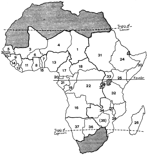
NORTHERN SAVANNA REGION
WEST AFRICA
CENTRAL AFRICA
EAST AFRICA AND MADAGASCAR
TROPICAL SOUTH AFRICA
In section 2.1 on present trends of natural woody vegetation, an important distinction has been introduced between, on one hand, deforestation in the strict definition of the term (paragraph 2.1.1), i.e. alienation of forest areas to permanent or shifting agriculture or to other uses, and, on the other hand, degradation of woody vegetation (in particular of mixed forest-grassland formations) which results from other factors such as fire, overgrazing, overexploitation for fuelwood and charcoal, etc (paragraph 2.1.2). In most cases degradation does not show up so much as a decrease in the area of woody vegetation but rather as a gradual reduction of biomass, changes in specific composition and soil degradation. Unfortunately these changes are very seldom quantified, and never at national or sub-national levels. Taking into account trends in forest utilization (paragraph 2.1.3), area and growing stock estimates are then projected at the end of 1985 (paragraph 2.1.4).
In section 2.2, forest plantation programmes are mentioned as well as their probable rates of implementation in the period 1981–85. This allows for the projection of planted areas by species category up to the end of 1985.
A bibliography at the end of each country brief lists the main documents which have been used for assessing forest resources and their trends. These references are presented in chronological order, since the date of publication is particularly relevant to such a study.
4.1.2 Tables
In addition to some tables related to less important issues a number of basic tables have been set out to illustrate the text, as shown below:
“Areas of natural woody vegetation estimated at end of 1980” (paragraph 1.1.2)
This table provides areas (to the nearest thousand ha) of natural woody vegetation classes according to the classification presented in section 2.1 above. Area estimates at the end of 1980 are derived from corresponding areas at previous reference dates, which may be that of an inventory, a reconnaissance or a map at national level, and which are corrected to account for deforestation during the period between this reference date and 1980. Explanatory comments follow the table.
“Growing stock estimated at end 1980” (paragraph 1.1.3)
On the basis of area estimates given in the above table and of mean gross volumes per ha (VOB) and of mean “presently commercialised volumes” (VAC) (to nearest m3), derived from forest inventory results and other data, it is possible to obtain estimates of total volumes for closed broadleaved forests, coniferous forests and productive open forests (NHc/NHO1). An estimate of mean and total volumes of forest fallow areas (NHCa, NSa, NHc/NHOa) has not been attempted because of the wide diversity of corresponding classes and lack of volume data. For the same reasons the volumes of unproductive open forests and of shrub formations (nH) have not been estimated.
Standing commercial volumes (VAC) are estimated only for virgin productive closed forests (NHCf1uv/NSf1uv) for which the volume extracted per ha is generally well known. Logged-over productive closed forests (NHCf1uc/NSf1uc) also contain exploitable volumes and some forests are indeed “creamed” twice or even more. However, it remains difficult, if not impossible, to assess the average commercial volume remaining in logged-over forests and no corresponding figures are given except in a few cases.
When no information is available on gross volumes (VOB) of logged-over productive closed forests (NHCf1uc/NSf1uc) it has been taken to equal the gross volume of the original virgin forest minus twice the volume of the extracted logs (2 × VAC) i.e. minus the gross volume of felled trees. This simplification assumes compensation between harvesting damage in the forests (negative factor) and the forest growth after logging (positive factor).
“Areas of established plantations estimated at end 1980” (paragraph 1.2.2)
Areas successfully planted until the end of 1980 are given in thousand ha (in general to the nearest 100 ha) by species groups and age classes, respectively for industrial plantations, non-industrial plantations, and all plantations. These estimates are net areas, which take into account rates of programme implementation, the beating up of unsuccessful plantations or the reforestation of logged-over plantations and the failure of some others. No detailed inventory of plantations at national level exists in any tropical African country, and this makes the estimation of the present situation difficult. In some cases, estimates of gross areas found in the documentation have been mentioned for the sake of comparison.
Some plantations have already been logged and replanted, or have coppiced, in which case, distribution by age class has often been given not only from the time of the first planting but also from the time of the new generation.
“Average annual deforestation” (paragraph 2.1.1)
This table gives areas of closed forests which have been cleared per year during the last five years (1976 – 80) and the corresponding projections for the next five years. As already mentioned, the concept of deforestation as used in this study implies the clearing of forest land for uses other than forestry (mainly agriculture), and its possible substitution, after a few years, by a secondary tree growth.
A logged-over forest which is not occupied by agriculture changes in forest category (from NHCf1uv/NSf1uv to NHCf1uc/NSf1uc) but is not deforested in the meaning used in this study, even if the extracted volume is relatively high (this is not the case in most closed broadleaved forests of tropical Africa, where logging is highly selective and extracted volume seldom larger than 20 m3 per ha). This type of transfer from virgin forests to logged-over forests is not reflected in this table. To determine the area of primary forest converted every year by clearfelling and by logging, one must add the area of virgin forest newly logged each year to the deforestation figure mentioned in this table.
In paragraph 2.1.1 indications are also given about the transfer of closed forests (NHCf/NSf) to corresponding forest fallow (NHCa/NSa) resulting from shifting cultivation in terrain of easy topography where soil reconstitution after cropping is possible.
Destruction of open tree formations (NHc/NHO) and that of shrub formations (nH) are also mentioned in this paragraph, as well as transfers within the NHc/NHO category, and those to nH category.
“Areas of natural woody vegetation estimated at end 1985” - “Growing stock estimated at end 1985” (paragraph 2.1.4)
These tables are similar to those of paragraphs 1.1.2 and 1.1.3. They provide estimates of areas and corresponding volumes as they have been projected on the basis of deforestation estimates for the next five years and of other assessments related to conservation and utilization of forests in the period 1981–85.
“Areas of established plantations estimated at end 1985” (section 2.2)
These tables are similar to those of paragraph 1.2.2 and take into account the projected areas of plantations established during 1981–85 on the basis of existing or planned programmes and of financial and other constraints faced by each country.
4.2 Results at regional level
The presentation of results at regional level in the next chapter uses the same outline as that of the country briefs. In the tables each line corresponds to a country and the countries are grouped in the five following subregions:
| Northern Savanna Region (6) | : | Chad, Gambia, Mali, Niger, Senegal, Upper Volta; |
| West Africa (9) | : | Benin, Ghana, Guinea, Guinea-Bissau, Ivory Coast, Liberia, Nigeria, Sierra Leone, Togo; |
| Central Africa (7) | : | Angola, Cameroon, Central African Republic, Congo, Equatorial Guinea, Gabon, Zaire; |
| East Africa and Madagascar (13) | : | Burundi, Ethiopia, Kenya, Madagascar, Malawi, Mozambique, Rwanda, Somalia, Sudan, Tanzania, Uganda, Zambia, Zimbabwe; |
| Tropical South Africa (2) | : | Botswana, Namibia. |
![]()
![]()
![]()