![]()
![]()
![]()
From December 1999 to March 2000, the highest rainfall rate since 1951 was recorded, triggering the worst flooding ever recorded in southern and central Mozambique. This rainfall was associated with twelve meteorological systems, namely cyclones and tropical storms (see Appendix 1) which originated in the Mozambique Channel in the Indian Ocean. The Mozambican Government assessed the dramatic consequences of this disaster over three dimensions:
Human dimension: a total of 5.2 million people were affected (30% of the Mozambican population): 699 people died, 491,000 were displaced and 95 disappeared.
Physical dimension: roads, railways and other infrastructures were destroyed; an area of 30,000 square kilometres was inundated from the Umbelúzi, Incomáti, Limpopo and Save River basins in southern Mozambique to the Búzi River basin in the central region of the country;
Economic losses: economic losses were estimated to have totalled USD 600 million, with a reduction in the country’s economic growth from 10 per cent to 3.8 per cent (GOM, 2000).
This event was reported as a ‘flood event’ because more people were affected by flooding than by rain. No exact data are available, but it affected the livelihoods of millions of people In central Mozambique about 1,730,600 people were affected. In Sofala, a province with an 87.9% poverty index, 257,908 people were affected: 101 died and 94,200 were displaced (ibid.). The high level of poverty exacerbated existing conditions of vulnerability and impeded recovery.
The heavy rains in other southern African countries[6], caused in part by cyclone Connie (which hit the area on 4th and 5th February 2000), and cyclone Eline (21st and 22nd February), were precursors to the Búzi flooding. This was in part because the extremely heavy downpour forced neighbouring countries to open their dams, resulting in excessive volumes of water entering Mozambique catchment areas. This exacerbated the local flooding triggered by the two successive cyclones. The Búzi basin, for example, was affected by waters released from neighbouring Zimbabwe, which forced the Chicamba Dam to be released, causing rising levels in the Búzi River and consequent flooding. This helps explain why floods in that area occurred some days after the cyclones had passed. Most communities in Búzi were declared disaster-affected.
With limited resources to respond to such an event, the Mozambique government was forced to seek assistance from the international community. From February to March 2000, they sent out international appeals which elicited a response of about USD 162 millions (GOM, 2000). This assistance was destined mainly for food, infrastructure reparation and rescue material (see Appendix 2). This assistance made it possible for people to buy essential goods, and funded services for the emergency operations being undertaken by state institutions, NGOs, UN agencies and religious organisations. The involvement of several organisations in the reception and distribution of aid made the operation more flexible and efficient. It was also possible to rescue 53,000 people, to provide emergency assistance to about 676,700 people in the established accommodation centres, and to start the process of population resettlement. Assistance was distributed using criteria based on the declaration of items lost.
This study aimed at understanding the role of local institutions and organisations in reducing people’s vulnerability to natural hazards in Búzi. To explore institutional coordination, the 2000 Mozambique disaster (floods and cyclones) was taken as a point of reference. To reach our goal, a research methodology involving multidisciplinary methods and techniques, previously discussed at UCT with the South African team, was applied. This will be discussed later in Part 1, as well as the criteria for selecting the study sites.
This report is structured as follows:
Part 1 presents a general introduction to the study, background on Mozambique, and identification of study sites. It also presents the methodology used for data collection.
Part 2 describes how early-warning mechanisms were operated, the role of informal social networks in emergency response, emergency assistance itself, the role of institutions in long-term recovery and risk reduction of at-risk communities.
Part 3 deals with institutional assessment at national, provincial and district levels.
Part 4 presents the lessons learnt from the 2000 floods, and addresses some recommendations to improve emergency responses and to reduce the vulnerability of at-risk communities.
Mozambique is one of the southern African countries most disposed to hydrometeorological hazards (Boudreau et al, 2002). In the last two decades climate-related shocks have tended to increase in frequency and severity, resulting in catastrophic damage to livelihood (ibid.). Data gathered during the last two decades suggest that, throughout the country, more than 8 million people were affected by natural phenomena (ibid.), the most frequent being droughts, floods and cyclones. They had a devastating impact on the most vulnerable 80% of the population, living in the rural areas.
The state of vulnerability of these people is aggravated by their extreme poverty, itself compounded by their limited access to essential services, by fragile infrastructures and by low productivity levels. Mozambique is one of the world’s poorest and most in debt countries (Abrahamsson & Nilsson, 1995), occupying position 170 out of 174 in the world poverty ranking (UNDP, 2002).
The extreme vulnerability of rural livelihood was generated in part by the Mozambican civil war that lasted for 17 years after the country became independent in 1975. This war caused demographic upheavals, especially in the rural areas. About 3.5 million people were internally displaced or became refugees in bordering countries (Devereux & Palmero, 1999). Other consequences included the loss of lives of approximately one million people (Pitcher, 1996), and landmines placed throughout the countryside made it almost impossible for rural people to access their cropping lands.
The civil war destroyed significant parts of the physical and commercial infrastructure in rural areas. Numerous roads, bridges, shops, schools and health-care institutions were destroyed (Devereux & Palmero, 1999; Pitcher, 1998) and caused US$15 billion worth of damages (Pitcher, 1996). According to calculations made by the UN, the cost of the physical destruction during the 1980s amounted to 250 years’ worth of exports at the 1992 level, and twice the annual influx of foreign aid (Devereux & Palmero, 1999 and Abrahamsson & Nilsson, 1995).
With the uncontrolled dispersion of communities, rural households lost their social networks, families were split up, and individuals were taken away from a context in which they could draw on mutual support, an important base for rural livelihoods. Mechanisms such as local norms and values, traditional rules, taboos and ceremonies that had influenced the sustainable use of natural resources and environmental protection were all abandoned, and traditional authorities that had been responsible for the dissemination of values and knowledge, especially to the younger generation, collapsed and lost their legitimacy. Indigenous knowledge of farming techniques, livestock production, and disaster prevention and preparedness were lost completely or replaced by others acquired from abroad or from other areas within the country, not always suitable for the local physical environment (Watson, et al, 1999). As an indirect consequence the vulnerability of rural livelihoods increased, placing these communities at greater risk to natural hazards.
The economic and political changes introduced in the early 1990s also exacerbated the situation of vulnerability. In 1987 when structural adjustments were introduced, state enterprises were privatised, leading to a decrease in the provision of goods and services to the poorest people, with negative impacts mostly on poor Mozambican households. Politically, the country observed changes of legislation in response to global economic and political changes. Several policies were amended and some new ones approved specifically to include a livelihood component, especially in rural communities, but most of these policies did not have the desired results. The most important policies and legislation are indicated in Appendix 3.
The 2000 floods that affected the country opened a window of opportunity for the government to move faster towards the definition of a legislative framework on disaster management. By 2001 the Law of Disaster Management was finally approved. This law aimed at establishing strategies, plans, legal norms and operational programmes for disaster prevention, aid and rehabilitation. It was also intended to reduce communities’ vulnerability through a continuous, integrated, multidisciplinary and multi-sectoral process, based on an adequate information and communication system (Bill of the Law of Disaster Management, 2001). This legal tool recognises the role of local governance in reducing the vulnerability of communities at-risk, but its focus is still predominately on the protection of state resources. Indeed, national strategies are still based on disaster management or on strengthening the state’s capacity to respond to disasters, with a limited focus on increasing the community’s capacity to prepare for and respond to disasters or to reduce risk conditions. The challenge for local government is to strengthen local communities’ capacity to cope, whilst linking them to external support at both local and national levels.
The case study was to take place in the Búzi River basin, in central Mozambique. This region was chosen for the following reasons:
This part of the country is one of the areas most subject to flooding;
Since the floods of 2000, the area has been continuously affected by cyclones, affecting the livelihoods of thousands of people reliant on subsistence agriculture.
During the floods of 2000 this region witnessed the arrival of hundreds relief workers from national and international organisations, both governmental and non-governmental. Although problems emerged from the lack of coordination between these organisations, the role of local institutions in disaster management became a significant issue of debate.
It should be noted that, although the Búzi basin was one of the areas most affected by the 2000 floods, the disaster situation has not been as extensively profiled as the flooding in the Limpopo basin, in southern Mozambique.
Initially two study sites were selected along the Búzi basin: the Búzi district in Sofala province, and the Mussorize district in Manica Province. Owing to unforeseen administrative circumstances it was, however, not possible to conduct research in the Mussorize district. The main reason for choosing these two sites was that, although the two districts were affected similarly by the 2000 floods, they were not covered in the same way by early warning information, rescue operations, assistance measures (sanitation, medical assistance and shelter) and resettlement and reconstruction programmes. Most of the aid supplied was concentrated in the Búzi district rather than in Mussorize. (See the map in Appendix 4).
Another reason for choosing these study sites was their geographical position: up till now most studies carried out in Mozambique have taken place in the south. This is a result of historical regional inequalities - infrastructure and accessibility are better developed in southern Mozambique, where the capital of the country is located. Central Mozambique, especially Sofala Province, is the poorest region of the country and has been neglected by the national government because it is considered as being dominated by opposition forces. It is also the area most affected by the recent civil war.
In addition, this region presents an historical picture of the influence of traditional authorities. After independence, power was removed from traditional authorities who were seen as the product of colonial rule. People unfortunately did not recognise the important role of existing local authorities in allocating resources to sustain their means of livelihood. However, these authorities continue to play important role in reducing people’s dependence on natural resources, as they replace absent state institutions.
An administrative circumstance in the Mussorize district required a shift in the initial research design, and in the end research was undertaken only in Búzi. In this district two study sites, Munamícua and Boca, were selected. The first criterion for selection of these sites was that both were affected by riverine flooding (natural events), although the intensity and impacts differ between the sites. The second criterion was based on geographical situation: Munamícua is situated within the Bândua administrative area, while Boca falls under the Estaquinha administration. The proximity of Munamícua and the remoteness of Boca from the Búzi headquarters were considered important elements in this selection. The underlying assumption was that, with Munamícua closer to the Búzi headquarters, there would be more efficient institutional coordination and communication. This was understood as being a major factor in the rate of response and recovery, influencing the vulnerability of these communities. In the case of Boca, where there are only limited social infrastructure and facilities, the vulnerability of the communities was considered higher.
It also important to note that information collected in previous interviews with people in Maputo and Beira helped to choose these sites. Some organisations that had already worked in these areas provided us with basic information about the area, including the presence of local institutions, conditions of accessibility and working conditions.
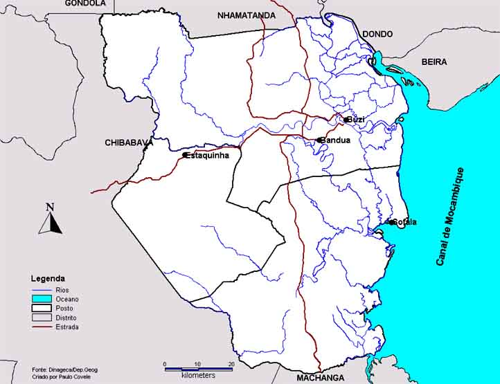
The Búzi district, with a population of about one and a half million (INE, 1999), covers an area of a little over 7000 square kilometres and is divided into three administrative posts namely Búzi, Estaquinha and Nova Sofala (see Figure 1 below). The two communities taken as study sites are situated along the lower part (floodplain) of the Búzi River. The river is 379 kilometres long, with its catchment in eastern Zimbabwe.
Búzi is characteristically a very poor district with households basing their means of livelihood on agriculture and livestock. In order of importance the most important crops are maize, sorghum, rice, beans, sweet potatoes, groundnuts and vegetables. Livestock is the second main activity that guarantees the subsistence of most of the households studied. Goats, chickens and ducks are the most common livestock produced in both areas. Livestock is partly used for consumption but mostly it is sold, especially in today’s situation when diverse and regular sources of cash-based income are considered a more appropriate indication of wealth (Kepe, 2002). Money from these transactions is used to access health assistance, to buy food in time of hunger and to pay children’s school fees.
Munamícua falls under the Bândua local administration in the Búzi administrative post. In terms of traditional structure[7] it is a Povoação falling under the Bândua Regulado. According to the latest population census, there were 3,634 inhabitants in 1998, divided into 753 households (INE, 1999). The main activity of the population is small scale agricultural production, followed by livestock farming. Agriculture is seasonally based, with maize, sorghum, rice, beans and fruit constituting the main crops. In terms of livestock production (at household level) the most commonly reared animals are cows, goats, ducks and chickens. The impact of flooding on the livelihood of this community was very significant as a large part of the population use the floodplain for agricultural production and livestock farming.
Figure 1: Map of the case study area, showing Estaquinha and Bândua
Boca falls under the Estaquinha local administration, with 13,922 dwellers divided into 287 households[8] In terms of traditional structure it falls under the Boca Regulado. The main means of livelihood of the population are based on agriculture and on livestock rearing. They too produce maize, sorghum, rice, beans and fruit. Many households also farm livestock, such as goats, ducks and chickens. Differing from Munamícua, in Boca the cattle production has been problematic due to the prolific presence of tse-tse fly. In 2000 the Boca community was affected mainly by the tropical cyclones and not by flooding, as they are positioned away from the Búzi River.
Preparatory meetings to discuss the research design and methodology were held with the Disaster Mitigation for Sustainable Livelihoods Programme (DiMP) of the University of Cape Town. Following the initial meetings, a profile of the study site was prepared and submitted to the FAO (United Nations Food and Agriculture Organisation) for approval. Subsequent meetings were held with the DiMP research team, who were conducting an assessment of the March cut off low in Montagu, South Africa, to streamline the research and ensure that approaches and methods were consistent.
Coordinating the Mozambique team was Zefanias Matsimbe[9], a Masters student from the University of the Western Cape. Assisting him were two researchers, Lúcio Chiteve and Chabane Injoma[10], recommended by Franziska Steinbruch of the CIG-UCM.
In the field, Nicolas Lamade of the GTZ provided logistical support, including the identification of institutions in Beira and Búzi working in disaster management, identification of the study sites, and transport.
The Mozambican team used different methods for data collection in the field, from national, provincial and district structures, and from the local community (study sites). For a better understanding of the methods used, we divided these into two categories. The first category relates to institutional assessment of national and local government, international agencies and community leaders, and the second deals with community assessment. The following subsections give details of the methods used for data collection in both categories.
The institutional assessment involved interviews at both national and local level, before community-based assessments were undertaken[11]. At the national level several government departments were contacted, including the INGC, the UNDP, FAO, Save the Children (UK), UNICEF, the Ministry of Agriculture and Rural Development, the National Directorate for Water Management, Eduardo Mondlane University and the Land Studies Centre at Eduardo Mondlane University. Within each institution the internal emergency unit or section dealing with disaster management and emergency was contacted. For data collection, semi-structured interviews were conducted with the coordinator of the section or unit.
Interviews concentrated on the following three areas:
the role of the whole organisation in reducing people’s vulnerability to natural hazards;
intra- and inter-institutional coordination between departments working on disaster management at national, provincial, district and local levels;
assessment of the level of success and the challenges faced in terms of institutional coordination and the integration of disaster management plans into governmental development plans or programmes.
In each department visited, documents and reports relating to disaster management were collected for future analysis. In some of these departments preliminary information on the study sites was requested, especially in those that had developed activities in Búzi through their provincial branches in Sofala Province.
In Maputo, the team attended a meeting between the government - represented by the Foreign Affairs Minister, government departments[12] - and the partners, donors and NGOs working on emergency programmes. This meeting provided insight into the inter-departmental and inter-agency coordination of disaster relief in Mozambique.
A similar approach was applied at provincial level in Beira, the capital of Sofala province, where interviews were held with the Head of the Provincial Department of Agriculture, Members of the Provincial Disaster Management Committee, researchers from the Catholic University of Mozambique, the Provincial Department of INGC, the Mozambican Red Cross (CVM), GTZ, and the Provincial Statistical Department. Fortunately, in Beira there were greater opportunities to interview government agencies and the Provincial Commission for Emergency Response than there had been in Maputo.
Semi-structured interviews were conducted in Beira with key members representing the government at the provincial level. The aim was to ascertain their role in disaster management, assess the challenges faced, and determine what were the institutional mechanisms for interdepartmental and interagency coordination at the local level. During these interviews, reports and government documents were requested. To complement these reports, local newspaper articles relating to disaster incidents were collected and analysed.
At the district level, in Búzi district headquarters, local administrative authorities and some government departments were interviewed using semi-structured interviews. The aim was to assess the coordination between the district- and provincial-level authorities, and between district and local authorities or local communities, as regards disaster management and risk reduction.
With the district administrative authorities, interviews were centred on profiling the district in terms of ‘disasters’, their impact on people’s livelihoods, the most affected areas, organisations involved in disaster management (pre and post-disaster), the main problems faced by local communities, the role of the local government in disaster management and risk reduction (prevention, mitigation and relief coordination and recovery). Within the government departments, emphasis was placed on understanding their role in disaster management, and the mechanisms for coordination with provincial authorities on risk reduction. Current vulnerability and risk reduction initiatives with local communities were also explored.
At a national level, UN agencies and one NGO (Save the Children) were assessed. Owing to time constraints it was however not possible to contact the CVM (Red Cross), a humanitarian institution that was actively involved in rescue and assessment after the floods of 2000.
At provincial and district levels, the Red Cross branches were the most important sectors in providing essential information as they had been actively involved in the management of the 2000 floods. They were in fact still running key projects on disaster prevention and livelihood improvement at local level. Other local NGOs and church-based organisations were also contacted. Interviews were conducted using semi-structured questionnaires.
Within the Boca and Munamícua communities interviews were carried out with the local traditional authorities (community leaders) and randomly selected households. In both areas two group discussions meetings were arranged with men and women separately. This decision came after a discussion within the team, taking into consideration the cultural reality of the community. The team concluded that the probability of hearing ideas from women in joint group discussion was limited, because men traditionally monopolise discussion, preventing the expression of gender-sensitive issues. The idea of conducting interviews with separated groups was successful because all people were free to talk.
In both gender meetings the focus was on the following:
frequency and intensity (taking the 2000 floods and cyclones as points of reference);
impact on people’s livelihoods;
the role of local institutions in prevention, preparedness, mitigation and recovery before and after an event;
institutional coordination within the community, and between the community and local administration.
In assessing the impact of natural hazards on the community livelihoods, the following were considered: resources available locally, access to and control over main livelihood strategies, and the challenges faced by the community in improving their livelihoods within the cycle of the agriculture calendar.
With a central focus on the 2000 event, the aim of the interviews with the community was to recreate their experiences of the event, to understand what had really happened, how they had survived, who had intervened and, if they had, how long after the disaster, whether organisations that intervened were still working within the community and, if they were, what kinds of programmes they were implementing to reduce vulnerability to natural hazards, and what was the role of traditional and administrative authorities in disaster management.
In each local community ten households were interviewed to understand in-depth the livelihood aspects of activities, assets, strategies, opportunities and the impact of natural hazards in the context of household coping mechanisms. However due to time and accessibility limitations it was not possible to cover more households. In the Boca community particularly, households are very dispersed around the forest and accessibility was very difficult and dangerous, due to wild animals. Some areas were only accessible by bicycle. In Boca, five of the ten households lived on upper ground and five alongside the Búzi River. In Munamícua, five households were interviewed in the Zindoga sub-area, the most flood-prone area close to the river, and five in Inhankondo, a less vulnerable area to which people were moved during the 2000 floods.
At both sites interviews were also conducted with members of different organisations working locally such as teachers, church members, and rural agrarian extension officers, to assess their role in emergency response and risk reduction. Furthermore the challenges that they faced and the level of collaboration with and acceptance by the local communities was also assessed. Transect walks and participant-observation were used as complementary research methods to understand physical aspects that could not be expressed by the interviewers.
In conducting the fieldwork a range of local factors limited research. The main constraints were:
Bureaucracy: Due to an unforeseen administrative circumstance (no letter of permission) it was not possible to conduct research in Mussorize (Manica province);
Political atmosphere: As the study was carried out in the year of municipal elections, in some cases team members carrying out fieldwork were misinterpreted as being members of a political party in the pre-electoral campaign;
‘Disasters’ and false expectations: Both study sites were affected by drought and famine while fieldwork was being carried out. The arrival of the research team (by car) gave the starving villagers false expectations: they assumed that they were members of a non-governmental organisation or government agency bringing aid assistance.
Long period after the event: The fact that the research was undertaken two and half years after the event meant that many people could not remember exact details. This was exacerbated by high levels of illiteracy in the rural areas, which inhibited written documentation of the event. Both communities confirmed that they had received external assistance from many organisations, but most people could remember only a few of them. To name the organisations involved we had to use data from previous studies, especially that of the CIG-UCM (2003) who provided an overview of the institutions and organisations involved;
Physical inaccessibility: Both study sites were situated in areas where, owing to poor road accessibility and the danger of wild animals, it became difficult to conduct interviews with the dispersed households.
Health Conditions: The fieldwork was carried out during the peak of a measles and malaria epidemic, which had caused several deaths in the communities visited. In Munamícua, for example, several interviews had to be cancelled because the potential interviewees had to attend funerals of relatives, neighbours or friends. In certain cases the team was involved directly in these events, for example with a family which had lost four children in two weeks due to measles. The situation was very risky and by the end of the fieldwork period all the team members were infected with malaria.
|
[5] Most of the data reported
in this section were taken from GOM (2000). We clearly acknowledge the source
and the copyright. [6] Botswana, Zimbabwe, South Africa and Swaziland. [7] To be explained later in this report. [8] Source: local traditional leaders; confirmed in INE (1999). [9] Having conducted related research in Mozambique on a number of occasions, Zefanias Matsimbe has been working with the Eduardo Mondlane University for the past three years, as well as with international institutions such as the Institute of Development at the University of Sussex, UK. [10] Students at Beira Pedagogic University, Mozambique. [11] A recognised constraint was that the institutions were still highly bureaucratic. It is important to understand that over the previous decade Mozambique had been a communist country, characterised by a heavily structured institutional bureaucracy. Although this is no longer the official status of the country, it is still a reality deeply entrenched within government institutions. [12] Weather Forecasting, Water Management, Agriculture & Rural Development, Health, Trade, and the INGC. |
![]()
![]()
![]()