![]()
![]()
![]()
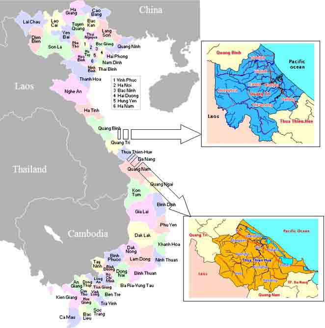
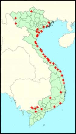
Quang Tri, located in the central part of Vietnam, is bound by Quang Binh Province in the north, the province of Thua Thien Hue in the south, Lao PDR in the west, and China Sea in the east (Figure 1). It has 9 administrative districts, two of which are the townships of Dong Ha and Quang Tri. Though its land area is not very large, Quang Tri’s terrain is relatively diverse, sloping from the west to the east, creating four natural geographical regions: mountainous, midland, plain and coastal. Its mountains, with elevation from about 200 to 2000 m above sea level, form part of the Truong Son range. Of its total land area of 470,000 hectares, about 57,000 hectares are devoted to agriculture. Coastline is 71 km long.
Its three major rivers have a total length of 1,095 km, with a total basin area of about 3,640 sq km. These rivers are relatively short, but highly sloped from west to east, which, combined with its high flow rate, would be ideal for building reservoirs and hydroelectric plants. The hydroelectirc power potential of Ben Hai River is estimated at 834 million kWh, the My Chanh River, 376 million kWh, and the Thach Han River, 1,800 million kWh. The provincial profile is presented in Table 1.
About 65% of Quang Tri’s more than 60,000 population are engaged in agriculture. Crop production predominantly depends on the climate, and, being most vulnerable to climate variability and the El Nino Southern Oscillation, is very much unstable.
Table 1. Provincial profile, Quang Tri
|
Province |
Quang Tri |
||
|
Capital |
Dong Ha |
||
|
Population (2001) |
588,600 people |
||
|
Total land area |
470,000 hectares |
||
| |
Hills and mountains |
|
81%; elevation: 200-2,000 m above sea level |
|
Flatland |
11.5%; elevation: 3 m below sea level to 50 m above sea level |
||
|
Coastal |
7.5%; elevation: 0-3 m above sea level |
||
|
Land use |
|
||
| |
Agriculture |
57,000 ha |
|
|
Forestry |
72,000 ha |
||
|
Graze land |
4,000 ha |
||
|
Unused |
270,000 ha |
||
|
Major rivers |
|
||
| |
Ben Hai |
963 sq km |
|
|
My Chanh |
847 sq km |
||
|
Thach Han |
2,800 sq km |
||
|
Climate |
Dry season (Mar-Aug), rainy (Sep-Jan) |
||
|
Average temperature |
25oC (hottest recorded was 40oC) |
||
|
Average annual rainfall |
2,000 - 2,700 mm |
||
|
Cropping season |
Winter-spring crop: Dec-Apr |
||
| |
Summer-autumn crop: May-Sep |
||
Source: Central Committee on Flood and Storm Control - Quang Tri Province
Climate
Quang Tri’s climate is relatively harsh, mainly influenced by the hot dry southwest wind, storms and heavy rainfall. The province lies in the tropical monsoon zone influenced by the convergent climate of the subtropical North and the tropical South. There are two distinct seasons: the rainy season, with storms and tropical cyclones characterized by heavy rainfall and strong winds, from September to January; and the dry season, with little rain, from March to August. Hot dry wind blows from the southwest for about 40 to 60 days a year.
Annual average rainfall is about 2,000-2,700 mm; annual average temperature is 25oC. Average monthly humidity is from 85% to 90%.
Hazards
The provincial Department of Dyke Management and Flood Control (DDMFC) ranks hazards in Quang Tri according to decreasing severity of impact as follows:
1) Drought
2) Saltwater intrusion
3) Inundation
4) Flooding
5) Typhoon
6) Tornado
Drought. The plains are most vulnerable. During the dry season, flows of small streams are not adequate to supply reservoirs for domestic use, requiring transportation of water from other provinces. The El Nino-induced drought in 1998 was the most severe, when small streams dried and large river systems experienced the lowest flow at 1.5 m/s. Reservoirs dried, and caused a water crisis. Dong Ha’s 60,000 people and about 20,000 from other areas were without drinking water. The 2003 drought is similar but with less severe impacts to the 1998 drought due to the intervention by mass organizations and the government.
Saltwater intrusion. Seawater flow 20-30 km inland through the rivers, affecting river quality and ecology. The problem is most pronounced during drought conditions, when river flow is not enough to flush saline water to the sea.
Inundation. Sand dunes that form near the mouths of rivers impede drainage to the sea, causing inundation in the plains. Average depth of inundation is 2-3 m, with the lowest areas at about 4m. Hai Hoa commune in Hai Lang District is most vulnerable. The canal system that runs along the sand dykes helps in draining water to the sea.
Flooding. Floods are typically brought by storms and tropical depressions that bring rain from the South China Sea. Steep rivers cause floodwaters to arrive quickly in the plains. The flood season begins in September and lasts till November. Hai Lang District, with an elevation of 1 - 0.5 m below sea level, is flood-prone. Residents often evacuate to higher grounds. The 1999 flood is the most severe, causing 56 deaths. Of the 4,000 mm rainfall for the year, 3,000 mm fell in just 9 days.
The river dyke system protects the plains from the floods that come in the beginning of the rainy season, and enables farmers to harvest their dry season crop.
Typhoon. Typhoons bring heavy rain accompanied by strong winds and high waves along the coast. The worst typhoon event was in 1985. Gio Linh was one of the districts that suffered heavy damage when about 70% of dwellings were destroyed. Many international organizations provided assistance during the recovery period.
Tornado. Tornados affect the mountainous areas, usually at the beginning of the rainy season.
Others. Sand deposition caused by strong winds is a grave concern, as it renders agricultural lands infertile. Sand dykes provide relief, and prevents seawater from moving inland. River bank erosion is also a problem, forcing residents to move to other locations.
Gio My Commune, Gio Linh District
Gio Linh District has 20 communes, of which 3 are coastal and prone to cyclones and saltwater intrusion, 6 are lowland and prone to inundation and drought, and 11 are upland and prone to drought. District officials reported that every year, an average of 2-3 cyclones hit the district, and 4-5 flood events occur.
Gio My commune is located in a lowland area between the mouths of 2 rivers. Sand dunes, 21-38 m above sea level, line its coast to the east. Of its 3,000 ha land area, 1,300 ha are used for agriculture. A communal reservoir irrigates 300 ha of farmlands; the remaining 1,000 ha are rainfed. Farm productivity is 2.2 tons rice/ha. Groundwater can be accessed during the dry season if rainfall during the preceding wet season is sufficient to replenish the aquifer.
There are about 1,200 households, with an average size of 4 people per household. Average landholding per household is 600 sq m. Majority of the population are engaged in subsistence farming. Rice is the main farm crop; other crops include cassava, sweet potato, chili, watermelon, and soy and mung beans. Most households raise pigs and chickens. Most young people, more than 80% of which are women, migrate to the cities to work in factories. Others are engaged in small businesses that cater to the community. More than 20% of the population is below poverty.
Because of its location, Gio My is prone to inundation during the wet season, affecting households about 2-4 times a year. The first rice crop (winter-spring crop) is planted in December to avoid early floods, at the same time to take advantage of rains towards the end of the wet season. This crop is also prone to pest/plant disease. Farmers said that in the last 10 years, they lost their first crop 4 times. During the dry season, most of its farmlands that rely solely on rains are prone to drought. Hence the second crop, planted in May and harvested in September (summer-autumn crop), is highly vulnerable to water shortage. Commune officials remember the impact of the 1998 drought when farmers lost 1,000 ha of the summer-autumn rice. This year (2003), of the 400 ha planted, 180 ha were lost to and 100 ha were affected by drought.
Forests, which protected the lowland against sand carried by the wind from the sand dunes, were destroyed during the Vietnam War. Commune officials said that about 6 ha of land are covered by sand after each storm, rendering vulnerable farmlands infertile. They recognize the need to reforest as a prevention measure.
Saltwater intrusion is also a problem, but minimized by a gate installed in one of the rivers.
Hai Hoa Commune, Hai Lang District
Hai Hoa Commune, bound by 3 sub-rivers of the Hai Lao River, is located in the lowest area (elevation of 50 cm below sea level) of Hai Lang District. The commune has 5 villages, 3 of which are centrally located, and the other 2 are kilometers away from the center, which, according to commune officials, makes administration difficult. Population is 6,300 from 1,004 households.
Of its 912 ha land area, 686 ha is agricultural land, 655 ha of which is paddy. Productivity is 5 tons rice/ha. Most households each has an average of 50 heads of ducks/chickens and 4 heads of pigs. Most have backyard gardens planted with chili, nuts, etc. Non-farm activities include wage labour (about 350 construction labourers migrate to Hue) and fertilizer production (60 households are involved in small-scale compost making). The commune has a public market built 2 years ago. Most households store paddy for their annual consumption. Poverty level is at 15.8%, an improvement from the 2001 figure of 22%.
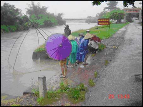
Because of its location, Hai Hoa is prone to inundation during the rainy season. Farmers rent motors to pump water out of the plots to support rice crop during the rainy season. This contributes to high production costs, which, in addition to processing and transportation costs, has reduced farmers’ net income to 35% of his 3,600,000 VND (USD 240) gross income per capita per year. The commune has an ongoing program to reduce production cost by shifting paddy cultivation from 2 to 1 cropping and using the freed plots for fish and lotus plants during the wet season when areas are water logged.
During an intense rainfall upstream, the commune is prone to floods brought by the rushing waters of the steep Hai Lao River. The floodwaters arrive quickly, but drains poorly due to the elevation of the area. Residents, however, have developed a sense of when the floodwaters will come, based on observation of rainfall and river depth.
Saltwater intrusion is a problem during the dry season, when river flow is not enough to flush the saltwater.
For farmers in the lowlands of Central Vietnam, flood and inundation have the most impact. The second rice crop is vulnerable. Farmers attribute poor yields or crop losses either to floods arriving too early and damaging crops or to inadequate flood control structures. Like in the midlands, their success rate is poor in harvesting the second rice crop. Respondents said that flooding has become almost an annual event.
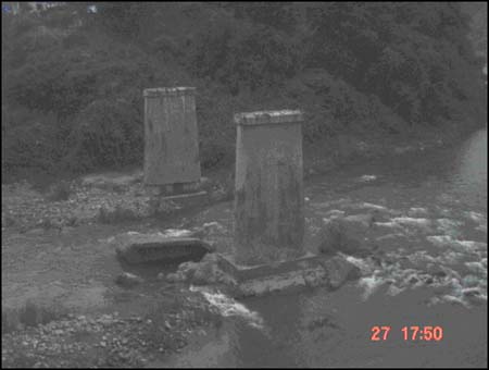
Damage from more serious floods depends upon the nature of the flooding. Floods with strong currents are characteristic of many areas in both the north central and central coastal regions. These are aggravated by dyke breach, high winds and sea surges, and are a danger to human life and property, as well as to irrigation and public infrastructure. Livestock (particularly smaller livestock such as pigs and chickens) may be drowned or washed away. Sea surges caused by storms pose a hazard to farmers whose dwellings or farmlands are near the coast.
Floods that are less violent but inundate large areas over long periods of time are less immediately devastating. However, they have severe economic and social impacts. Damage to crops and property occurs as a result of fields and houses standing in water for long periods of time. Articles for household use may be rendered unusable, and the house structure may be weakened. Losses of food stocks stored in the house (as well as crops on the land) may threaten food security until the next harvest season. Livestock that survive the flooding may succumb to epidemics that occur following the flood.
Floods of long duration can cause severe social impacts during the flood itself. Health, particularly of the elderly and disabled family members living in poor conditions with limited food stocks, unclean water sources and poor sanitation, is a grave concern of people interviewed. Schooling can be disrupted for long periods, especially when buildings require repairs. Children are most at risk from flooding. While more than swimming skills are needed to save even the strongest adults from strong currents, it was disturbing in the field interviews to hear of people who had died in relatively calm waters simply because they could not swim.
Drought and saltwater intrusion during a drier dry season also affect the second rice crop.
Thua Thien Hue is bordered by Quang Tri Province to the north, Da Nang City and Quang Nam Province to the south, Lao PDR to the west, and over 120 km of coast to the east (Figure 1). As in Quang Tri, the land slopes from the west to the east. About 70% of its land area of 5,009 sq km is mountains and forests. The Truong Son range (800-1000 m elevation) stretches about 60 km along the Lao border. The Bach Ma Cao (1,444 m high) and Hai Van mountains (1,160 m elevation) form part of the 70 km range along Quang Nam and Da Nang. The midland is hilly, accounting for a quarter of Hue’s land area. The coastal central plain is narrow but long, stretching along the northwest and the southeast. Sand dunes, 5-30 m high, run along the coast. Hue’s population of 1,050,000 (1997) occupy 1.5% of the land.
Hue’s main rivers are Huong, O Lau, Bo, Truoi and Cau Hai, running eastward across the province. Most originate from the mountain ranges, passing the plains through marshes and ponds to the sea. The Huong (perfume) River is the largest, with a basin of 300 sq km. All rivers drain into the lagoon, with an area of 20,000 ha and 70 million cu m reservoir capacity. Because of the sloping topography, floodwaters run quick and fast eastward. Its 168 km dyke system can only control early flooding.
Climate
Thua Thien Hue’s climate system is similar to Quang Tri, with two distinct seasons: the rainy season from September to December, and the dry season from March to August. The rainy season receives about 70% of the total yearly rainfall, with the lowlands receiving twice the highland rainfall. Storms and tropical cyclones come mostly in September and October. Hot dry wind blows from Laos during the dry season, while cool air prevails in December till January. Annual average temperature is 25oC; annual average humidity is 84%. Average rainfall reaches 2,750 mm per year.
Hazards
According to the Chief of the Standing Office of the provincial Committee for Flood and Storm Control (CFSC), hazards in Thua Thien Hue include floods, cyclones, erosion, landslide, drought and saltwater intrusion. The 1999 flood was the worst, which inundated 90% of the lowlands. The province was isolated, and the only access was by air. The flood, which lasted for 1 week, broke 5 new floodgates and created a new river mouth near the lagoon. The heavy rainfall in the uplands caused landslides at various locations. The flood cost was 352 deaths and 1,700 billion VND (about USD 113 million) in damages. In mountainous areas, flooding in main rivers is a problem when the river overflows its banks and flood and inundate low-lying areas.
The most recent drought episode in the province occurred this year (2003). About 20% agricultural productivity was lost. Because of the significantly reduced river flow, seawater flowed inland for about 30 km and rendered the river water unfit for domestic use.
Hong Ha Commune, Aluoi District
Located west of Thua Thien Hue Province, on a branch of the former "Ho Chi Minh Trail" (a military supply route used by the North Vietnamese Army in the 1960s and 1970s), Hong Ha is the poorest of the 21 communes of Aluoi District. Of the commune’s 4,100 ha of land, 1,100 ha is forest and 296 ha is agricultural land. About 100 ha is planted to rice (20 ha under wet cultivation), the rest is with cassava, sweet potatoes, vegetables, etc. The main cultivation area is the flat land between the river and the hill slopes. The commune has 1,257 people in 446 households from 5 ethnic minority groups. Only 50% of the population derive income from their agricultural production, which they have to bring down for more than 50 km to Hue City. High input cost and low market price of produce is a current problem of farmers.
The commune has many creeks and rivers, including the watershed of the Bo River, which supplies the agricultural plain of Thua Thien Hue. The destruction of Hong Ha’s natural forest cover by chemical defoliants and bombs during the war has adversely affected the hydrology of the area. River water levels during the dry season are from 0.5-3 m, while during the rainy season are from 5-7 m, sometimes rising up to 10 m, bringing devastating floods both in Aluoi District and in downstream areas. The force of the river also erodes land from the riverbanks. Past events recalled by residents are the floods in 1953, 1975, 1983 and 1999. They said that the 1953 flood was greater in magnitude than the recent 1999 episode. Some creeks dry up during the dry season
Deforestation has also made some areas landslide-prone. Respondents noted that landslides started to occur after the war in 1975. The native vegetation has been replaced by the invasive imperata grasses, which has made cultivation difficult. The People’s Committee Chairman recognizes that reforestation will reduce vulnerability to floods and landslides, and have thus requested the planting of indigenous species. Hong Ha’s forest has been placed under the protection of the Ministry of Agriculture and Rural Development.
Hong Ha’s population is a delicate balance of 5 ethnic minority groups. Their way of life is different from those in the lowlands. For example, very few are engaged in monocrop; most would plant rice, tubers, vegetables, etc. They do not store food either. They collect only the things that they need for the next 3 days supply, such that most experienced hunger during the 1999 flood when the floodwaters wiped out their crops.
Electricity came in 1998, with 70% of the population currently connected. Other facilities include a primary school and a health care center. The Chairman of the People’s Committee said that malaria and digestive diseases are common.
In line with the government’s economic reform (doi moi[1]), the commune government opened its doors and welcomes foreign initiatives. One of these is an ADB project on poverty reduction, to address the 70% poverty level in the commune. The commune is also considering opening its 2 dams/reservoirs and waterfalls to eco-tourism.
The most damaging hazard experienced in the highlands is flashflood, as it occurs with little warning. People, property and livestock may be washed away. Crops planted on the hillsides are better protected than staple crops planted in river valleys, such as cassava, on which poorer farmers rely between paddy harvests. High dependence on subsistence farming renders highland populations vulnerable to hunger during the flood season. Floods from swollen rivers can cut off villages for days or weeks, which could result in food shortages.
Floods with strong currents cause permanent damage to fields, washing away the topsoil. Floodwaters also deposit rock and gravel onto fields. Heavy rains trigger landslides that cut off roads and communication networks.
Livelihoods in the plains and lowland areas centre on irrigated rice cultivation, cultivation of secondary crops and livestock raising. While these patterns are broadly similar to other lowland areas of the country, low living standards in the lowland and coastal parts of the central provinces are generally attributed to the extreme weather and frequent occurrence of natural disasters. Agricultural production is limited by poor, insufficient tracts of land, and inadequate irrigation. Unlike the fertile Mekong delta, farmers in the central provinces struggle to harvest two crops of rice. Those interviewed at the study sites continue to plant two rice crops but report losing part or the entire second crop on an annual basis. Even farmers who have made relatively successful investment in agriculture and livestock raising acknowledge that they do not "get ahead" by agriculture alone.
Having capital to invest has been one of the keys for households to improve their livelihoods in the last decade. Those who have been able to diversify sources of household income have had an advantage. For example, the ability to make investments in aquaculture (households along the coast) or to increase livestock herds and to commercialise handicraft production (Cham communities in the dry plains of Ninh Thuan and Binh Thuan), have been important factors in improving household well being and in absorbing shocks caused by natural hazards [4].
However, the poorest households in lowland and coastal (agricultural) areas lack the resources to improve their economic well-being, and are particularly vulnerable to economic shocks. Those households lacking capital to invest in agricultural production are among the poorer households in these areas. In addition, households in lowland and coastal areas must cover the costs for education and healthcare, which poorer households struggle to meet. Expenditures to treat sudden illness or chronic ill health in the family are a severe drain on the resources of such households. The poorest households in lowland areas are likely to be indebted, and to resort to strategies such as land mortgaging to cope, thus reinforcing the cycle of debt.
An increasingly common strategy in the central regions is for young people to migrate, either temporarily or long-term, in search of work. They go to Ho Chi Minh City, other urban centres, or the Central highlands, and nowadays even take up overseas labour contracts. Such is the extent of these movements that, nationally, central coastal and northern central regions have the highest rates of out-migration to other parts of the country (see Annex 1 on net migration rates by region).
The migrants are both men and women. In Gio My, Gio Linh District alone, 80% of the young migrant workers are women. About 10% of women in the commune have left their families and husbands behind to farm while they take up work as maids in Ho Chi Min City (HCMC), or on contracts overseas in Malaysia, Taiwan, or Japan. Some families have become women-headed, as men have left to take up work elsewhere. While for many of the families migration is temporary (money is sent home and the family member eventually returns), there are situations in which vulnerable women-headed households are created, as men have left home ostensibly to find work, but have effectively abandoned the wife and family.
There is also evidence that natural disaster is a strong motive for migration. In a study conducted in the central provinces in early 2000, respondents in Thua Thien-Hue stated that migration to the south had become even more popular in the wake of the severe floods in November 1999.
In general, lowland communities tend to have been long established at the sites where they live. Although many of these communities have experienced outward movements of population and (particularly in better-off families) now have wide networks of relatives, the communities themselves continue to be made up of related families who have lived in the areas for generations. Unlike the situation in the uplands, the site on which the village is located may not have changed for centuries.
In the hill land, swidden cultivation, although almost out of practice, still exists, but hidden, and is resorted to in cases of emergency. Hong Ha’s forest, now under MARD protection, is closely monitored by the Forestry Department. People are generally scared of the consequences of fire spreading from the swidden fields. Conversion of hill land for cultivation is very restricted. Though it is possible to get permission from the Forest Department, many households do not invest in the land because it can be claimed by the State for forest plantation with short notice. Large areas of hill land, which households have access to, are covered by imperata grass, which have spreading, tough root system that make cultivation difficult. People then return to old paddy fields, which are left fallow and have very low productivity.
Table 2 gives a summary of the hazards and existing coping strategies in the study sites.
Table 2. Hazards and current coping strategies in the study sites
| |
Exposure of agricultural system |
Hazards and public safety |
|
General features |
||
|
Rainy season: Sep- Jan |
1st crop (winter-spring): Dec- Apr |
|
|
Dry season: Mar- Aug |
2nd crop (summer-autumn): May- Sep |
|
|
Gio My, Gio Linh District |
|
|
|
Lowland |
Rainfed 2nd crop at risk to drought and saltwater intrusion during drier than dry season Coping strategy: gate installed in one of the rivers to keep saltwater out |
Flooding/inundation Typhoon |
|
Damage to 2nd crop when floods come early |
Drought impact on potable water availability |
|
|
Sand deposition Coping strategy: reforestation/aforestation for wind break |
|
|
|
Coping strategies/livelihood options: crop diversification, migration to cities, borrowing |
|
|
|
Hai Hoa, Hai Lang District |
||
|
Lowland |
1st crop vulnerable to inundation, requiring pumping water out of fields Coping strategy: 1 cropping to avoid flood season. Engage in fish culture and lotus plants during wet season. |
Flooding with strong current Inundation |
|
2nd crop at risk to saltwater intrusion Coping strategy: shifting of cropping pattern as above |
|
|
|
Livelihood option: livestock raising |
|
|
|
Hong Ha, Aloui District |
||
|
Highland 100 ha planted to rice 196 ha to tubers, vegetables |
Livelihood option: eco-tourism |
Floods, landslides Coping strategy: reforestation with indigenous species |
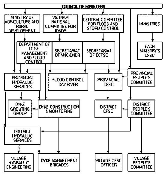
Vietnam has well-developed institutional, political and social structures for mitigating water disasters, which evolved over centuries since they exploited the great river deltas for agriculture. The building of dykes for protection against floods began in the 11th century. Today, there are about 5,000 km of river dykes and 3,000 km of sea and estuary dykes, mostly located in the North and Central Vietnam, protecting people, property and infrastructure, and making agriculture possible.
Department of Dyke Management and Flood Control
Since 1971, the body responsible for managing this elabourate system of dykes is the Department of Dyke Management and Flood Control of the Ministry of Agriculture and Rural Development (MARD). The central office sets and reviews overall targets, while the provincial department is responsible for allocating funds based on proposals from the districts. At the district level, officers evaluate the feasibility of new initiatives and monitor the condition of existing dykes. The commune level has a field engineer on staff and is responsible for organizing local participation, in the form of dyke management brigades who provide labour for dyke construction and maintenance. This division of responsibility, from national to commune levels, mirrors the overall political organization of Vietnam.
Central Committee for Flood and Storm Control
The Central Committee for Flood and Storm Control (CCFSC), and the committees at provincial, district and commune levels, was established in 1990 by decree (No. 168) of the Council of Ministers[2] (now called the Government). It is an inter-agency committee responsible for disaster management in Vietnam. It reports to the Government and is comprised of the following ministries and agencies:
Ministry of Agriculture and Rural Development (Minister as Chair, Vice Minister as Standing Vice Chair)
Government Office (Vice Chair)
Ministry of Interior (Vice Chair)
Ministry of Planning and Investment
Ministry of Finance
Ministry of Industry
Ministry of Trade
Ministry of Science and Technology
Ministry of Natural Resources and Environment
Hydrometeorology Service
Ministry of Health
Ministry of Construction
Ministry of Communication and Transport
Ministry of Posts and Telecommunications
Ministry of Public Security
Ministry of Labour, War Invalids and Social Affairs
Voice of Vietnam
Television of Vietnam
Its tasks include:
encourage and check with sectors and localities that plans are formulated and carried out annually for the purpose of prevention and control of floods and storms
issue orders for mobilization of human resources and funds to provide timely support to urgent situations, that sectors and localities are unable to solve
direct localities on how to overcome consequences of floods and storms
sum up performance of tasks to prevent and control floods and storms; introduce experiences and scientific and technological innovations in prevention, and control of floods and storms to sectors and localities.
The headquarters is at MARD. The Disaster Management Center acts as its Secretariat. It receives and disseminates warning, receives information on damages, and, as necessary, mobilizes resources in addition to the general fund allocated to each province for immediate relief. The Disaster Management Unit, a UNDP and USAID supported project, acts as an information node, securing and processing reliable and timely data from the nationwide network of CFSCs.
CCFSC’s operational budget is allocated from the annual budget of MARD. The Committee meets on a daily basis in the flood season and reviews the reports prepared by district and provincial offices the previous night.
Committee for Flood and Storm Control in Ministries, State Committees and General Departments
Each Ministry, State Committee, General Department has a committee for flood and storm control, chaired by its official. The committee is tasked to assist the Minister, Head of State Committee, Head of General Department to:
build and implement sectoral plans for prevention and control of flood and storm
maintain law and order
manage funds
timely provide supplies, facilities and means needed for relief as required by the CCFSC
rehabilitation and reconstruction
document experiences and lessons learned for sharing at all levels in all sectors
Committee for Flood and Storm Control at provincial, district and commune levels
The committees for flood and storm control of provinces, districts and communes are established by the Chair of the People’s Councils[3] at the same level. The committees are comprised of:
Chair of the local People’s Committee (Chair)
Head of DDMFC (Standing Vice-Chair)
Heads/Deputy Heads of departments concerned with prevention and control of floods and storms of the locality
Operational budget comes from the provincial Government. The tasks of the local committees include:
assist the People’s Committee of the same level to set up plans for the prevention and control of floods and storms and guide their implementation in their localities
monitoring maintenance of dykes
activities towards prevention of and protection of residential and commercial areas from floods and storms
issue early warning of hazard
receive feedback from lower level committees on actions done to prepare for an impending hazard and, based on this information, give instruction on further action
mobilize personnel and resources for emergency response
relief and rehabilitation
prepare damage and needs assessment report for sending to higher level committees
People’s Committees
The People’s Committee is elected by the People’s Council and acts as its executive body, and the Government’s administrative agency at the local level. It has responsibility for implementation of the constitution, laws, directives of upper government agencies and resolutions of the People’s Council. It has a Chair, a Vice-Chair, and a varying number of members (9-11 at the provincial level, 7-9 at district level, 5-7 at commune level). The Chair comes from the People’s Council; others need not. He also chairs the Committee on Flood and Storm Control. The task areas of the People’s Committee include planning, budget and finance; agriculture, forestry, fisheries, water conservancy and land; industry, small industries and handicraft; communications and transport; urban development, construction and management; trade, service and tourism; education and training; culture, information, physical training and sport; social affairs and life; science, technology and the environment, national defense; public security, social order and safety; implementation of policies for nationalities and religion; law enforcement; building of the local administration and managing of the administrative boundary of the locality; and special tasks for offshore districts. There are Special Committees on economics and budget, and on cultural and social life, and a Judicial Committee.
The Commune People’s Committee is the lowest political institution in contact with communities. It receives citizens’ complaints, denunciations, proposals, and opinions on issues related to the Communist Party’s lines and policies, State legislation and management of agencies and units. Meetings for this purpose are held at least twice a week, compared to at least once a month at the district level, stressing the importance of grassroot presence of public administration [ ].
Coordination between these government institutions is shown in Figure 2.
The Office for the International Decade for Natural Disaster Reduction (IDNDR) undertakes information dissemination and preparedness training.
Mass organizations bridge the Communist Party, the Government and the people. They are far-reaching and therefore have a great effect on social and community structures. They sit as members of sub-committees of local CFSCs.
Vietnam Fatherland Front
The Vietnam Fatherland Front was established by the Communist Party of Vietnam and President Ho Chi Minh on 18 November 1930 under the name Vietnam National United Front to raise the spirit of patriotism and unity, the decisive factors in gaining national independence.
The present Vietnam Fatherland Front is a political alliance organization, a voluntary federation of political organizations, socio-political organizations, social organizations, and outstanding individuals representing various social classes and strata, ethnic groups, religions and overseas Vietnamese. It is a venue in advocating patriotism, national pride, sense of self-reliance, and unity of all Vietnamese at home and abroad, irrespective of social standing and nationality, past and present ideology, and religion and belief, who approve the cause of renewal to strengthen national independence, unity, sovereignty and territorial integrity, and strives for the eradication of poverty and backwardness, aiming to be a prosperous people, a strong country, and a just and civilized society to realize President Ho Chi Minh's vision of "building a country, which is peaceful, unified, independent, democratic and rich enough".
The Vietnam Fatherland Front is a part of the political system of the Socialist Republic of Vietnam, under the leadership of the Communist Party of Vietnam. It:
provides a political base for the people's Administration
reflects the people's will and aspirations, building the block of national unity
advocates consultation, coordination and unity of action of its member organizations.
Its tasks are to:
gather and build the block of national unity
strengthen unanimity of spirit and politics among people
propagandize and encourage the people to exercise their right to be their own masters
realize the lines, advocacy and policies of the Party, and strictly execute the Constitution and Laws
supervise the activities of the State bodies, elected deputies and State officers and functionaries
collect people's opinions and their recommendations
reflect and propose to the Party and the State
participate in the building and enforcement of the people's Administration
together with the State, take care of and protect people's legitimate interests, and
take part in the development of relations and cooperation between the Vietnamese and the people in the regions and in the world.
The Vietnam Fatherland Front selects candidates for the People’s Councils for election by the people. The People’s Councils in turn elects the People’s Committees whose Chairs are also Chairs of the local Committees for Flood and Storm Control.
In times of disasters, the Fatherland Front calls for and channels emergency supply donations and coordinates with the mass media at central and local levels.
Women’s Union
Established in 1930, the Women’s Union advocates gender equality and the legal right of all women in the country, and takes part in the State Management. Organized at the central, provincial, district, commune and group levels, the Women’s Union carries out education activities to increase women knowledge and skills, supports poverty alleviation for poor women, and promotes mother and children health. Its tasks are:
policy implementation
development of household economy
training, education activities, knowledge and skills for women
strengthening of the Women’s Union structure
family planning implementation
establishing cultural families
supervision and control of all women’s activities
coordination with other agencies and organizations
The Women’s Union is actively involved in disaster preparedness, relief and rehabilitation through the following activities:
advise members to prepare emergency food
cooking at evacuation centers
assist the Commune Sub-committee on Flood and Storm Control on logistical requirements for response
assess local conditions as basis for distribution of relief goods and assistance
rebuilding of houses
extending credit to members at a very minimal interest rate.
training courses to enhance women’s skills and provide livelihood options
The Women’s Union manages a fund from member contributions. In Gio My, members contribute 5,000-10,000 VND each. Current fund available is 17 million VND (about USD 1,100) in Gio My, and 300 million VND (USD 20,000) in Hai Hoa. Members can borrow a specific amount according to level of fund. In Hai Hoa, members can borrow as much as 2 million VND (about USD 133) each for investment in livelihood projects. Payment is by installment.
Youth Union
The Youth Union includes 4 organizations:
Ho Chi Minh Communist Youth Union (HCYU)
Vietnam Youth Federation (VYF)
Vietnam Association of Students (VAS), and
National Council of Young Entrepreneurs (NCYE)
However, at the local level, only two are operating: the Ho Chi Minh Communist Youth Union (HCYU) and the Vietnam Youth Federation (VYF). Their functions are as follows:
The Ho Chi Minh Communist Youth Union
The HCYU was established on 26 March 1931, as the Indochinese Communist Youth Union. Its functions are:
reliable reserve force for the Communist Party of Vietnam (CPV)
as the socialist school for the youth, enables them to take part in activities beneficial to the country, and helps them grow and make contributions to the nation.
representative and protector of the legitimate and lawful rights of the youth.
member in the Party’s political system under the framework of the Constitution and other laws. In this system, the CPV is the leader, with HCYU as one of its members.
Operating under the direct leadership of the CPV, the HCYU is the reliable reserve force for the Party, supplying it with personnel to the requirements of its political tasks. The HCYU is the reliable mainstay of the State in the course of building socialism and defending the socialist country. The HCYU associates and coordinates with other agencies and mass organisations so as to achieve an aggregate synergy in educating, training, protecting and forging the younger generations.
The HCYU plays the core role in the organisation and operation of VYF, VAS and other collective members of the VYF. In charge of the Ho Chi Minh Young Pioneers Organisation (HYPO), the Union builds this organisation, selecting, training and fostering the cadres working with small children, and assisting financial and other facilities to the HYPO’s operation.
Vietnam Youth Federation
The VYF is a broad social organisation of Vietnamese youths and youth organisations. All Vietnamese youths aged 15 to 30 can be members. Membership can be individual (not associated with other youth organizations) or collective. Current individual membership is 2.5 million, and collective members include the:
Ho Chi Minh Communist Youth Union
Vietnam Association of Students
National Council of Young Entrepreneurs
The VYF operates under the principles of volunteerism, democratic consultation, self-management, coordinated and united action for common objectives, with the key role played by the HCYU. These principles also constitute the basis for the VYF’s consolidation and development. The VYF has a legal state, an account and a seal of its own.
Following are the main functions and tasks of the VYF:
provide guidance and facilities for its members to develop and perfect their personality to become good citizens, and to motivate them and other youths to participate in activities beneficial to the country, to families and to all those who can benefit from them.
represent and protect its members’ legitimate interests; cooperate with state agencies and social organisations to ensure the youth’s legitimate rights; and organise practical activities aimed to meet reasonable needs of its members and the youth in general.
achieve solidarity and cooperation with international and national youth organisations in promoting friendship, mutual understanding and cooperation for the sake of peace, national independence, democracy, social progress, and for the happy future of youths.
During disaster times, members of the Youth Union help in dissemination of warning, evacuation and rescue in close coordination with local authorities, and provides labour in rebuilding damaged houses.
In Hai Hoa, the Youth Union was established in 1975, with sub-teams at the primary and secondary school levels. Membership is voluntary (currently at 160 of the total 520 young people).
Veterans Association
The Veterans Association was established in 1989 for those who served in the army and now retired or moved to other sectors. It is a political organization with the following functions:
advise the Communist Party and local authorities
contribute to stability and socio-economic development
implement the resolutions and policies of the Party and Government
collabourate with other mass organizations in implementing all activities
encourage and help members who face difficulties
Economic development of the commune is a priority task. In times of disasters, the Veterans Association:
assists in damage assessment
extends credit to members
Fund is set up from contributions of members - each member contributes 300 kg rice, or its monetary equivalent. In Hai Hoa, additional funds are raised from exploiting unused agricultural land, with permission from the local People’s Committee. The Hai Hoa Veterans Association has current funds amounting to 20 million VND. Members can borrow as much as VND 300,000 each as seed money for livelihood projects, economic assistance for families undergoing financial difficulty, or assistance in house repair/strengthening.
Farmers Association
Established in October 1930, the Farmers Association is a voluntary organization operating from the central to the grassroots levels. Through its activities, the Association has contributed significantly to the development of Vietnam’s agriculture, despite the overall trend toward industrialization. It also launched emulation movements to encourage farmers to implement economic restructuring in agriculture, improve productivity and product quality, as well as increase competitiveness in domestic and foreign markets. The Association now enjoys the participation of nearly 10 million rural households across the country.
Together with the Party and State, the Farmers Association has helped reduce poverty in the country. Farmers can:
obtain loans from local authorities to develop their businesses
receive instruction on more efficient ways to do business
apply advanced technologies to their production
The Farmers Association aims at:
production development alongside environmental protection
maintain and increase the prestige of Vietnamese agricultural products on the market
build democratic mechanisms at the grassroots level through building a model of cultural families and cultural villages.
As a member of the Commune Sub-Committee for Flood and Storm Control, the Farmers Association undertakes the following preparedness, response and rehabilitation activities:
assist in dissemination of early warning
assist in evacuation and advises members where to move livestock
participate in rescue
assist in reconstruction of dwellings
facilitate mobilization of farmers’ assistance to those who are most affected (e.g. exchange of seeds for some other commodity)
advise farmers to plant cash crops for immediate food supply
Agriculture Cooperative
The Agriculture Cooperative is an economic institution for channeling agricultural credit to farmers.
Vietnam Red Cross
The Vietnam Red Cross (VNRC) was established in 1946, with Ho Chi Minh as honorary president. Currently, the State President is an honorary president of VNRC.
During the war, when it was founded, VNRC’s main tasks include undertaking relief operation, first aid and treatment of wounded soldiers. In 1957, VNRC was recognized by the International Federation of Red Cross Societies (IFRC). In 1975, it became independent from the Ministry of Health. During the same year, the Red Cross in the North and in the South united as the VNRC of today, with the following areas of focus:
support to disaster victims, which is its first priority
primary health care
institutional/staff development
humanitarian values development
Right after the Vietnam War, VNRC expanded to the grassroots level to help the victims of agent orange and dioxin, especially at the mountainous areas. Currently, its structure covers the national, provincial, district and commune levels. It has offices in 61 provinces and 500 districts, with volunteers in 90% of the total number of communes. Its volunteers currently number at 10 million.
The Government of Vietnam financially supports VNRC activities, and personnel at national, provincial and district levels (support for Chairmen of People’s Committees at the commune level is currently being worked out). External support funds programs and projects as well. IFRC, in addition to providing technical support to VNRC, joins VNRC in launching international appeals in times of disaster, when VNRC is unable to meet emergency requirements.
VNRC is involved not only in relief work, which it does with a high degree of effectiveness utilizing its nation-wide network, but also in disaster preparedness. Activities being undertaken include:
Prevention and preparedness:
planting mangroves along coastal dykes. At end of 2003, 20,000 ha have been planted in 8 coastal provinces.
operation of about 40 disaster preparedness centers (Figure 3), used as base for relief operations and fund raising. Some of these centers also deliver emergency care and medicines free of charge for the very poor. Each center has a store of basic relief items.
shock brigades of 20-50 members each, trained on how to prepare for disasters, first aid and emergency relief in more than 4,000 communes. They are on call during emergencies in the communes.
training for primary schools in the central provinces on how to prepare for disasters
public education and awareness raising in communes through campaigns and posters
two major relief warehouses (in the North and South), holding emergency food, clothing, first aid kits, etc available for rapid distribution during disasters
building of flood shelters which are used as classrooms at normal times
equipping of 3 hospital boats
Response, relief and rehabilitation
evacuation, rescue and relief in coordination with local authorities
administering first aid
preparation of needs assessment report
reinforcing houses, building of typhoon-resistant houses
Red Cross volunteers in the communes:
assist in evacuation, rescue and relief
assist in cleaning up operation
help in repair of damaged houses
Other Mass Organizations
Other mass organizations in Vietnam include:
Education Promotion Association whose main task is to promote education in society
Old Peoples Association, whose membership includes those who have retired from government work, and farmers aging over 55. Their activities are:
Protecting the rights of old people.
Implementing and disseminating policies to members
Contributing in recovery and conservation of traditional customs
Assistance provided by international NGOs cover preparedness, relief and rehabilitation. If disasters affect areas where they are present, implementing long-term development projects, they are able to provide direct relief/rehabilitation assistance [3]. In areas where they are not present, response is based on an appeal by the government or IFRC and information obtained from the Disaster Management Unit (DMU), IFRC, or directly from local agencies. Funds and relief assistance are channeled through IFRC, VNRC or local organizations (e.g. People’s Committee, Women’s Union). These international NGOs include CARE International, Catholic Relief Services, CECI, CISP, Cooperation Internationale pour le Development et la Solidarite (CIDSE), Malteser, Oxfam, Save the Children Alliance, World Vision International, etc. Assistance provided include:
Preparedness and mitigation:
integrated in long-term development projects in the field of education, agriculture, health
preparedness training
setting up early warning systems
reforestation/aforestation
building of hospital boats
building water supply storages
Relief:
provision of food, shelter items, health kits
Rehabilitation:
repair/rebuilding of houses
rebuilding of clinics, schools
rebuilding of bridges
provision of fishing boats, fish nets, seeds, fertilizers
micro-finance
Being prone to inundation and drought, people are aware of the hazards that come with the seasons. Households and local authorities engage in a whole series of activities at least a month before the storm and flood season. People would usually undertake repairs of dwellings, reinforcing pillars and roofs. Banks of paddy fields are shored up to avert damage and losses. Harvested paddy is kept on elevated storage. Animals are move to safer grounds. Emergency food (e.g. noodles), firewood and medicine are stocked. Local authorities as well as mass organizations, like the Women’s Union and Farmers Association, may play a role in encouraging households to make such preparations.
In some villages, people fetch bamboo to make rafts; sometimes banana trunks are put aside for the same purpose. Households who own boats have these at the ready, perhaps bringing them on to land nearer the house, in case they are needed when it floods. Preparation of drinking water depends on the available sources. In some villages, water tanks set high above the ground are one way to ensure the domestic water supply is protected from flooding. These tanks are not that popular as yet however, despite their benefits, because the cost remains prohibitive for many households (and some were concerned they attract mosquitoes). Households that rely on well water may prepare stores of water in advance of the flood season.
The communes visited have existing disaster preparedness plans, prepared with participation by mass organizations, detailing tasks of its sub-committees in addressing prevention and preparedness, response and rehabilitation. For example, Hai Hoa’s disaster preparedness plan was drawn in 2000 by an 8-member committee. The plan was finalized in a meeting with commune officials, with inputs from lessons learned from the 1999 experience. Simulation exercises were conducted in 2000, with financial assistance from the province. Three plans were drawn addressing:
1) Protection of agricultural production
2) Protection of infrastructure
3) Evacuation, and search and rescue
The plan on food security provided strategies such as crop rotation, early harvest, and emergency preparations such as moving crops to higher area. Four thousand tons of rice are stockpiled in the commune hall, and renewed each year. The plan to safeguard infrastructure included measures for electricity supply, canals, etc. The plan on evacuation and search and rescue identified sites for the evacuation of groups of households. Emergency health care was also given importance: the commune hall was designated as the emergency health station, able to administer primary health care and handle emergency births. Sanitation was given priority, with a clean up operation undertaken after each flooding episode, as the commune receives all kinds of debris and dead animals brought by the rushing floodwaters of the Hai Lao River.
In 2002, village sub-committees for flood and storm control were established. Members report to the Chair of the commune CFSC. An organizational chart clearly delineates roles and functions of each member of the commune and village sub-committees. These sub-committees each have 5 units that oversee health care and the environment, infrastructure, evacuation and search and rescue, relief, and logistics.
The sub-committee tasked on relief ensures that all emergency requirements such as food supply, logistics and personnel are available on site. (A national policy that resulted from the great flood of 1999 is self-help by communes, recognizing that they are the first ones to respond to a disaster. External assistance is extended upon their request, when they are unable to meet their emergency requirements.) A control room in the commune hall transmits early warning information by radio.
As part of the Central Government’s policy on living with floods, the school calendar was shifted to enable children to stay with their families during the flood season.
The provincial office of the Hydrometeorological Service (HMS) of Vietnam provides warning for an impending cyclone, flood or drought. In Quang Tri, hydrometeorological data from observation stations at 5 locations are used to generate forecast. Additional 5 stations operate during the flood season to monitor water levels in rivers. The provincial forecasting center (HMS) is also networked with other provincial centers in the Central Region.
Flood forecasts issued by HMS have 4-6 hours lead time, allowing adequate time for evacuation. (People are already on alert mode during the flood season.) Communication of flood warning is by high frequency radio, while cyclone warning is through the mass media (TV, radio and newspapers).
Warning of an approaching hazard is received by the district CFSC, and is then relayed to commune CFSCs by radio. This triggers a flurry of activities in the communes. A member of the commune CFSC sub-committee on early warning goes around informing people using a loudspeaker. Members of the Youth Union and Farmers’ Association assist in the dissemination of early warning. They and Red Cross volunteers also help in evacuation. Evacuation is started when the floodwaters start to rise. Shelters at the sand dunes and commune halls, which are built with second floors, are used as evacuation centers. Dwellings with second floor also accommodate neighbors who are in distress.
Rescue at the commune level is undertaken by a CFSC sub-committee, with assistance from the Youth Union, Farmers Association, Farmers Cooperative and trained Red Cross volunteers. (Part of the commune CFSC preparatory activities is the identification of able-bodied men who can assist in rescue operation.) External rescue assistance from the province involves the army, police and the coast/border guard. The Red Cross and district health clinics provide emergency health services. Some members of the Women’s Union are also trained to assist in emergency deliveries of babies.
The commune CFSC undertakes relief activities with assistance from the Women’s Union and the Red Cross. Members of the Women’s Union cook food at the evacuation centers. Relief goods are usually distributed equally since, according to CFSC officials, it is difficult to determine the extent of damage per household in an emergency situation. Rehabilitation assistance however is based on household needs. Emergency goods come from the CFSC store as well as from the Red Cross. In the 1999 flood, relief goods from non-government organizations flooded the communes, such that commune CFSCs had difficulty coordinating distribution.
A rapid needs and damage assessment is conducted by the CFSC, with assistance from the Veterans Association, Women’s Union and Agriculture Cooperative, as well as the Red Cross, to provide basis for rehabilitation assistance.
Compensation
Levels of compensation for households affected by disasters are, in principle, set by official government guidelines. These are issued through the Ministry of Labour, War Invalids and Social Affairs (MOLISA). They establish minimum levels of compensation for a death or injury in the family, and for damages to or losses of property and crops. According to MOLISA representatives in Hanoi, each province must put aside a yearly budget to enable it to compensate households at least to these minimum levels. Actual levels of compensation are established at the discretion of each province according to its budgetary ability. If the province cannot meet the requirements, it may ask the centre for budgetary assistance.
In practice, better-off provinces may budget for much higher levels of compensation, while poorer provinces may not be able to offer compensation to people affected by natural disaster at levels established in national guidelines. Provincial representatives of MOLlSA in the relatively wealthy province of Tien Giang reported that levels of compensation given from that province to people suffering losses and damages during the floods of 2000 and 2001 were twice as high as those established by the national guidelines. By contrast, in provinces in the north central region, little reference was made to established government levels of compensation, and local people did not refer to these guidelines when discussing relief assistance received from the State.
The law on water resource (No. 8/1998/QH10) passed in May 1998 provides that funds for prevention, response, rehabilitation and reconstruction activities for water-related emergencies (flood, drought, saltwater intrusion, hail and acid rain) would come from the State budget, the reserve State budget, local funds contributed by the populace as prescribed by the Government, and assistance from foreign organizations and individuals.
The provincial CFSC receives an annual allocation from the CCFSC for relief operations based on previous annual budget. Additional fund from the Central Government may be accessed for special projects. Funds are provided to districts according to need.
People are asked to contribute one kilogram of paddy per labourer annually (or its cash equivalent of 5000 VND). Amounts raised are sent up to higher levels (percentages retained at district and provincial levels) to be used for relief, rehabilitation and reconstruction following floods and storms. The commune does not retain any percentage.
At the field sites visited, actual levels of contribution to this fund and amounts collected varied. Contributions were being made at the stated level in some villages, but in other villages people said that poorer families were permitted to contribute 5000 VND per household (rather than per labourer). In one commune, local authorities said the level of contribution in that commune had been recently reduced from 5000 VND to 3000 VND per labourer. Respondents in another commune said that as a whole, the commune had not made its full contribution to the fund in the previous year because they were too poor.
The Red Cross makes a call to people through its local branches to donate for disaster relief in other localities in response to a specific event. Funds are sent through the Red Cross to the area in need, to be used for relief only.
Some local Red Cross units also raise their own social support reserve funds, to be used within the commune or village to help victims of disaster (or people otherwise in need). These funds were found to be more prevalent in better-off villages, in lowland areas, and particularly in places where out-migration was high and migrants returning to visit could be called upon to make a contribution. Village Red Cross units in Quang Phuc Commune, (Quang Trach District, Quang Binh) had managed to build reserve funds of up to 8 million VND. While this type of fund is o ften collected by the local Red Cross, some communes and villages collect similar funds which are called 'humanitarian' or 'friendship' funds and are not associated with the Red Cross.
Local level fund for disaster relief and household social assistance are also raised by mass organizations such as the Women’s Union, Veterans’ Association and Agricultural Cooperative through contribution of members. These however may be accessed by members only. These funds are less common in upland areas than in lowland and coastal areas. Where they exist in the uplands, amounts raised tend to be lower than in the relatively better-off lowland communes. In those villages and communes that did not collect such local reserve funds, it was either said that people were too poor to do so or that they preferred to contribute only in response to a specific event.
Donations for disaster relief from the international community are received by the Vietnam Fatherland Front, Vietnam Red Cross and the Aid Recipient Unit of the Finance Ministry, as designated by the Government.
Key personnel of the Disaster Management Center and some provincial CFSCs have received training in disaster management from regional centers such as the Asian Disaster Preparedness Center (ADPC). Currently, a program is being worked out to train provincial and district CFSC officials in disaster management. Funding proves to be the main constraint in operationalizing this.
The Red Cross and various international NGOs have training as well as public awareness programs at the commune level. Red Cross offices at district or provincial levels train Red Cross leaders at the commune level in preparing for disasters, first aid and emergency relief. They, in turn, train local volunteers. In April 2001, VNRC, assisted by IFRC, developed an action plan to make its disaster preparedness program more community-based. Part of this plan is the training of provincial and district VNRC staff on community-based disaster management (CBDM)[4]. (Some VNRC staff have been sent to ADPC to receiving training in disaster management (Disaster Management Course and CBDM) since 1998.) In the same year (2001) ADPC adapted its regional CBDM course and developed and delivered a national training course in Vietnamese language for VNRC. More than 20 trainers were trained on CBDM.
In Hue, the Canadian Centre for International Studies (CECI) has adapted this CBDM course to integrate climate change impacts on and adaptation strategies for floods. An adapted CBDM course has been tested in several communes.
|
[1] The doi moi reform,
instituted in 1986 to address Vietnam’s economic crisis, consisted of 6
major policy changes: 1) the decentralization of state economic management,
which allowed state industries some local autonomy; 2) replacement of
administrative measures by economic ones, including a market oriented monetary
policy, which helped to control inflation; 3) adoption of an outward orientated
policy in external economic relations - (exchange rates and interest rates were
allowed to respond to the market); 4) agricultural policies that allowed for
long-term land use rights and greater freedom to buy inputs and market products;
5) reliance on the private sector as an engine of economic growth; and 6)
letting state and privately owned industries deal directly with the foreign
market for both import and export purposes [5]. [2] The Council of Ministers (now called the Government) is the highest executive body in Vietnam, and is responsible for the management of the economy and of the State. It is composed of the Prime Minister, Deputy Prime Ministers, Ministers and the Chairmen of the various State Committees and the Governor of the State Bank. The Prime Minister is elected and may be removed by the National Assembly, the supreme representative and legislative body, which determines both domestic and foreign policy. The Deputy Prime Ministers and the Ministers are selected by the Prime Minister, but must be approved by the National Assembly. The Prime Minister is a member of the National Assembly; other members of the Government may not necessarily be. Decisions on major issues are taken on a majority basis. [3] Below the Government are the People’s Councils, the authority of the State at the provincial/city, district and commune levels. Members are elected or may be removed by the local people. (Candidates for election are selected by the Fatherland Front or are self-nominated. The final list of candidates is drawn by the Fatherland Front.) The People’s Council is accountable to the people and the superior State bodies. At the provincial and district levels, the Council has a Standing Committee, composed of the Chair and Vice-Chair of the People’s Council elected from among the members of the Council, and a number of Special Committees. The commune People’s Council does not have a Standing Committee or Special Committees, but has a Chair and Vice-Chair. The People’s Council is responsible for ensuring strict local observance of the Constitution and laws and for ruling on local plans and budgets. Its task areas include economics; culture, education and social affairs; science, technology and the environment; defense, security, social order and safety; implementation of policies for nationalities and religion; law enforcement; building of the local administration and managing administrative boundary of the locality; supervision of other organizations; special tasks for offshore districts; discharge and planning; and urban development. Operational budgets come from the revenues of each locality, supplemented by allocations from the central budget. [4] The CBDM course includes modules in participatory community risk assessment, identification of risk reduction measures and action planning. |
![]()
![]()
![]()