


Thailand is a predominantly agricultural country with 78 percent of its population engaged in agriculture. Presently its major export crops are rice, maize, and cassava. During the 20th century the area of agricultural land has increased primarily at the expense of the area of forested land. This leads to shortages of wood, food and fuel materials and has caused environmental deterioration (Sutthisrisinn, 1998). It is estimated that 10 million out of approximately 59 million people are dependent on forest resources for livelihood in Thailand according to statistics from 1995 (Poffenberger, 1999).
The impressive economic growth has mainly been concentrated to Bangkok and the surrounding provinces. The average income per capita in Bangkok is still 12 times higher than the countrys poorest region, the Northeast (ibid.).
Although extensive political measures for protecting the remaining forest area and reversing the trend have been enforced, the deforestation rate for the last century as a whole has been high in the whole country, especially in the Northeast Region. Sixty percent of the land area in this region was covered by forest in 1952, this figure decreased to 28 percent in 1973 and to 14 percent in 1988 (Saowakontha, 1994). Commercial timber exploitation combined with land clearing by both local and migrant farmers are commonly stated as reasons for deforestation. Public concern over disastrous flooding and landslides in southern Thailand triggered a national logging ban in 1989. This marked an important policy shift towards greater emphasis on the involvement of communities in forest management activities (Poffenberger, 1999). There is an increasing number of national parks which is in line with the 1985 National Forest Policy aim of reaching 40 percent forestland cover. However, conflicts do occur between local people and the government about the use versus protection of forest parks.
While Community Forestry Management (CFM) legislation has not yet been approved, the concept has gained legal support under the new constitution and decentralisation laws1. Before CFM laws are enabled, current conservation policies are unfortunately at odds with the community rights provisions listed in the Constitution (ibid.).
The two types of land in Thailand are land with private ownership, referred to as deed land2 and land with use right that cannot be sold3. There are several grades of usufruct tenure, where the differences concern user rights, tax, legal documents etc.
Over the past 30 years, a number of policies supported by the Ministry of Interior, the military, and the RFD have legitimised the expansion of communities into the forest reserves, especially in the northeast Thailand. These included the establishment in 1975 of the National Forestland Management Division (NFLMD) within the RFD to administer the Forest Village Program and the national Forestland Allotment (STK) project. To support these programs the Thai cabinet gave amnesty to all illegal residents in reserved forest (Hafner & Apichatvullop, 1999).
To solve the problem of more than one million families illegally occupying forest reserve land, the Thai government implemented the Sor Tor Kor in 1982. This is a usufruct license that grants the right to occupy and farm up to 15 rai of forest reserve for an initial period of approximately five years (Maokham, 1997).
In the study areas, tenure arrangements include Por Bor Tor 5, and the Sor Tor Kor. Both have usufruct status and can be passed on to family members but the land cannot be sold. In the case of the Sor Tor Kor, where the land is allocated from degraded forestland, the household is required to give up farm land that exceeds the 15 rai for reforestation (ibid.).
Ban Na Por Song Village, Nam Nao District, Petchabun Province
Ban Na Por Song is the village closest to the study area 1, situated 3 km Northeast of the site. According to the village history, a hunter founded it three generations ago when travelling through the area. He decided to settle, and cleared the land for agriculture4. The population of the village is steadily increasing, with continuous inward migration primarily from further East and from the Khon Kaen area. Due to this growth, the original village has now been split into several administrative units with respective village leaders (headmen) in 1985. Today there are villagers of two administrative units interacting with the forest of study area 1. The most recent settlement (Moo 4) consists of 134 households located along the road. The other settlement, Moo 5, has 270 households and the houses are clustered. Most of the families are descendants from original settlers.
In 1977, the area was changed from being a sub district (Tambon), to a bigger district (King Amphoe). With the new status came increased presence of the authorities, among others through a government office and some military presence, as is normal in a King Amphoe. One effect of the development was increased control over remote forest areas and for the same reason local people were encouraged to settle in forest areas.
The main livelihood of the inhabitants of Ban Na Por Song is cultivating cash crops such as ginger, corn and lychee. Paddy and upland rice are primarily for household consumption. Some people also have orchards.
Non-wood forest products are important, especially for the poor and land-less new settlers. During the rainy season, mushrooms and bamboo shoots can provide an important income supplement.
The National Park of Nam Nao, situated two km south of the study area, covers an area of 96.000 ha. The boundary of the National Park also covers forest area in Loei Province, Khon Kaen and Chaiyapoom Province. It was declared a national park in 1965 despite protestors pursuing it to the Court. When it became a national park, people had to be relocated and all agricultural and construction activities in the forest stopped. This included halting a project to build a dam across the Huay Chern stream bordering the national park for producing electricity. However, the power supply problem was solved in 1977 when the village got electricity from another dam.
The forest area outside of the national park was logged in 1982 when the government authorised a concession to a logging company. Workers came with the company from other regions and extracted timber until the national logging ban was enacted in 1989. The concession and the uncompleted dam project left a network of good roads and tracks in the area.
There is a 3,200 ha community forest that is used by the villagers. It was established in 1996, and was formed in what was previously called the Common Land. The community forest is divided in respective zones: Conservation-zone and a User-zone. This has involved changes in the regulations and rules for the land use, described later in this report. Important functions of the user-zone of the community forest are provision of non-wood forest products, construction wood and areas for grazing.
The community forest was established after several villagers participated in a visit to a community forest in Lumpoon Province (close to Chang Mai) that was promoted by the RFD and a Non Governmental Organization (NGO). This event also coincided with village area being upgraded to an official District (Amphoe), four years ago. This milestone, was part in triggering the change from Common Land to Community Forest.
A small sacred forest is located on the eastern side of the village. The belief is that the spirits of the ancestors reside there. Out of respect, there is neither harvest nor collection of forest products. As described other religious ceremonies in the forest has also taken place.
Tree Ordination
On two occasions in specific parts of the community forest, there have been organised Buddhist rituals (buad pa) to ordain trees. The first occasion coincided with celebrating the 50th Anniversary of the Coronation of the King of Thailand. The nation-wide program aimed to protect 50 million trees (Hoare et. al, 1997). In Nam Nao, together with 2000 people visiting, and as a collective activity with the people, monks performed ceremonies where important trees were picked out and marked as sacred. In the community forest, the ordained trees have a yellow cloth-rope tied around their trunks. Sacred trees cannot be cut. This cultural innovation of religious practice has been respected, and also used with animist hilltribes, so in fact, it helps create awareness of the need for forest conservation. This religious activity has gained vast interest and support form the public media, of which many have come to recognise the existence of forest dwellers through participation in the ritual (Luangarmsi, 1997)
According to the remote sensing study, the forest cover had changed from closed forest to long fallow in the change polygon where study area 1 was located. The change has taken place in the Western part of the square.


Figure 4. Study area 1 on the Landsat TM image from 1998 (T3) (top left and right), and on an aerialphotograph from 1996 (lower left). Boundary between closed forest and other land in study area 1 (lower right).
The land use in the area is diverse. In figure 4, the boundary shows a rough split into a part with predominantly agricultural land use and one part with forestland use.
This part of the study area is dominated by permanent agriculture, with occasional fallow-like fields. Mechanised tillage is widespread. Fruit tree plantations, fish ponds and paddy rice fields were also noted.
Fire is still a frequently used method for clearing land (almost everywhere there were signs of fire).
Although some evidence of cutting and burning in the boundary zone to the forest, it was not enough to conclude that the agricultural part is still expanding.
 |  |
Fig. 6. The agriculture part of study area 1 is dominated by permanent agriculture. A few fields were left in fallow. The regeneration, however, was set back by annual fires.
The forest is heterogeneous with a mixture of forest types and species groups. Dry deciduous forest mixed with pines dominated on the dry ridges and evergreen broad-leaved trees dominated in the wetter low-lying parts of the terrain along streams and in valley bottoms. Common on the lower slopes along the streams were also dense stands of bamboo. The following species were identified as common forest species at study area no. 1:
Pterocarpus macrocarpus Memecylon scutellatum
Pinus kesiya Dipterocarpus intricatus
Careya sphaerica Euginia cumini
Cratoxylum spp. Garuga pinnata
Cananga latifolia Croton robusta
Stereospermum neuranthum Castanopsis spp.
Schima wallichii Lithocarpus spp.
Laegerstroemia macrocarpa Quercus spp.
Anneslea fragans
Large parts of the forested land had previously been used for agricultural purposes. Now they had been abandoned. The explanation for this changed land use was the relocation of farmers from the forest to the agricultural lands on the other side of the road in connection with the establishment of the Community Forest. Furthermore, planting of trees (Oxylia xylocarpa, P. kesiya and Pterocarpus macrocarpus.) in open areas in the forested part had taken place during the last couple of years.
In the forested part, there were traces of fire almost everywhere and often the natural regeneration and the planted seedlings had been damaged or killed by the annually recurring fires. Many stumps showed that there was a lot of tree cutting in this part of the study area.
There were no signs of grazing in the forested part of the study area the reason being that grazing was restricted to a different part of the community forest, according to the local guides. According to the local guides the forest in the study area used to be much more open, when there was still grazing.
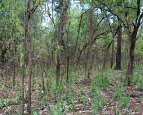 |  |
Fig. 7. Dry dipterocarp forest (left) and abandoned fields (right) from the forest part of study area 1.
In order to collect qualitative information on forest cover change in the study area, the principal stakeholders7 were identified: The Villagers, the Community Forestry Committee, the RFD Protection Unit and the Watershed Management Unit.
Non-wood forest products, such as mushrooms and bamboo-shoots, farmland for agriculture and wood for construction are the most important land uses of the study area for the villagers. Forest in general is also used for grazing, hunting, and cultural aspects such as ceremonies in the sacred forest and tree ordination.
Non Wood Forest Products
Table 2. A listing of the most common products collected from the forest. The marked products (*) are ranked as the most important.
|
Forest Product |
When Collected |
Use |
* Various mushrooms species |
Rainy Season, depends on rain, but normally April/May |
Food, marketed if surplus. The price varies from 40-100 bath/kg depending on species. |
* Bamboo shoot, various species. |
Rainy Season, April/May, the big Bamboo shoot in June |
Food and to market |
Edible Fern (Pak Kood) |
Rainy season |
Food , and market 3-5 Baht per kg. The price has gone down due to high supply |
Bamboo sp. various |
Rainy Season and some later in June |
Food and to market |
Young shoot of rattan |
not known |
Food |
Old rattan |
not known |
Weaving |
Palm species Hua Peng |
not known |
Food (the bulb is edible) |
Wild ginger |
not known |
|
Wild vegetable |
not known |
Market |
Sweet vegetable (Pak Wan) |
Rainy Season |
Only available in national park. Good price 60-100 bath/kg |
Medicinal plants |
All year |
Medical treatment, i.e. muscle pains etc. |
|
Animals |
All year |
|
Birds, various, esp. doves |
All year |
Food |
Lizards (ta kua), |
All year |
Food |
Snakes |
All year |
Food |
Wild hen |
All year |
Food |
Wild pig |
All year |
Food |
Armadillo (nim) |
All year |
Marketed for medicinal purposes. People extract a potion from its scale, and keep it alive (esp. the young). A middleman is contacted in Khon Kaen when they find one. Young nim (3-5kg) is worth 500 bath/kg. Older nim (up to 10 kg) is worth 200-300 Baht/kg. |
Barking Deer (Geng), and other deer |
All year |
Food (illegal to hunt) |
Fish from streams |
All year |
Food |
Mushrooms and bamboo shoots are important products for family subsistence and almost all families collect them. There are special delivery points in the village where people sell their harvest. Middlemen come and buy from these points directly. Mushroom picking is important for generating extra income, especially for the poor and land-less. In the village today, twenty households are landless.
The price varies according to the mushroom type, but it is normally between 40 Baht/kg to 100 Baht/kg. Bamboo shoots are sold for approximately three Baht/kg. A large shoot can weigh up to two kilos. Both products can, in certain periods, reach prices between 80-160 Baht/kg.
Mushroom picking is predominantly a female activity, but during the weekend people come from long distances to collect mushroom. It is sometimes also regarded as a social outing to the forest, with both women and men participating. Occasionally, disagreements occur about who occupies certain picking areas but they are usually resolved quickly. The informal rule is, however, first come first serve. There is no right to exclude others, nor any restriction on whom may pick where.

Figure 8. Women in the Nam Nao forest after a morning of mushroom picking
Agriculture
There are agricultural fields in the study area. The explanation given to why agricultural practise is occurring is due to the fact that villagers were forced to move their farmland out of the forest five years ago. It was accepted that these individuals needed farmland and dispensation was given to concentrate some fields in an area where the forest was degraded many years ago.
Grazing
There is no grazing in the study area today. A specific grazing zone for cattle has been identified within the community forest. The villagers have pooled the cattle and four families have been given the full time job of herding and feeding. Cattle must be herded since cattle-owners are responsible for damage done to farmland by grazing cows. This is different from the rules of the previous Common Land, where the custom was that no compensation was given and where people fenced in their farmland to protect the crops.
Tenure
The Community Forestry Bill has still not been passed by the Parliament, therefore the community forest has no formal document yet. The informal agreement of having agriculture in this area (user-zone) means that the tenure arrangement is also informal. Part of the communal land was allocated to farmers as compensation from having to move their fields out of the forested area. The particular farmland has a usufruct status for families that cultivate, but there is no formal ownership. If a Community Forestry Bill is passed it is uncertain what kind of status this area would get.
In contrast, the tenure system applied in other farmland of the village, is a document showing that villagers have the user right to the land and that they are obliged to pay annual tax to the government of 5 bath/ rai. This type of tenure is called Por Bor Tor 5. The document does not include maps indicating the land borders. Agricultural farmland varies between 40-100 rai (6.4-16 ha) in size and is inherited to both women and men. The land can be leased (this is done informally on a village basis) but not sold.
Burning of grass and weeds is common practice for land preparation in the study area. However, it happens that it gets out of control and there is a problem of annual fires in the forest. Various reasons are given to the causes of fires. They can be triggered by certain hunting practices, such as smoking out animals, or drying the ceramic clay bullets that are used in the slings for killing birds. Careless cigarette smoking in the forest is mentioned as another cause. The fires mostly extinguish by themselves after a couple of days. In some cases, the RFD will intervene. Interestingly, it was mentioned that where cows are grazing there is less burning, because the ground vegetation is eaten.
Tree Cutting
The Community Forestry Committee (CFC) grants permission to cut trees in the user-zone of the community forest for the following purposes: a) to poor people8 for housing-construction9, or b) repair and construct public buildings. This was not the case ten years ago when no permission was obtainable.
Villagers expressed that illegal cutting continues. It is common today that external people from outside the village hire poor people in the village to cut.
Fuelwood is not extracted in large quantities from the study area or from the forest in general. People get fuelwood from areas closer to the village where they live, for example, from the farmland and fruit-orchards. Women utilise fuelwood, charcoal and gas for cooking.
The newly established Community Forestry Committee (CFC) has nine members, of whom two are women. They were selected by the Sub-District (Tambon) Council and are still defining their role and activities. Meetings are held on an informal basis.
One of their activities is granting cutting permits for house-construction and for public buildings, such as temples and schools. Before cutting takes place, those who fulfil the criterias must specify how many trees and what tree species they want to cut. It does not seem to matter where the cutting takes place; but the CFC must be solicited. The committee then informs the RFD.
Allegedly there have been incidents where settlers, who were granted wood to build a house, were actually only speculating. When the wood was cut and the house was built, they sold it immediately for a profit and moved out of the community. Consequently, the committee now tries to check whether the newcomers are intending to settle permanently. A norm has been established that smaller trees are granted for cutting either for the first house or if there is uncertainty whether the family will stay long term in the village. Bigger trees are permitted cut for permanent settlement.
The main responsibility of the RFD Protection Unit is to protect the forest from illegal cutting, forest fires, and to work with public relations such as awareness raising. There is a problem of understaffing and underfunding of the office. The RFD office is located near the village centre. Confiscated logs that have been cut illegally with chainsaw are stored beside the office.
The forest under the responsibility of the Protection Unit is subjected to special restrictions due to being classified as a conservation and watershed area. In the conservation area, only mushrooms and bamboo shoots can be harvested. Fuelwood cannot be extracted. In the watershed area, there are stricter regulations. Neither mushroom nor bamboo shoots can be collected.
The RFD regards illegal cutting in the forest as a predominantly internal problem. Local people are mainly responsible for opening new land to grow ginger. Trees that are cut in order to access the land are either burned or sold. The RFD did not go into details about to whom.
When the RFD patrol arrests people they are brought to the police station in Ban Na Por Song, put to trial, and fined. In the period from October 1999 to April 2000, the RFD arrested nine locals for illegal cutting. Collaboration between the RFD and the villagers is improving. Especially long-term residents co-operate in trying to extinguish fires and in reporting illegal cutting. This is a consequence of the establishment of the community forest.
The role of the Watershed Management Unit is to reforest the watershed area (Nam Chern). When the unit was created in 1996, an officer with support staff from Khon Kaen was employed. At this time numerous agricultural fields in the forest where found that people claimed as theirs. There was resistance to stop cultivating on these farmlands.
There is still some way to go in order to overcome communication problems and mistrust between the unit and the villagers. One example is that the Watershed Management Unit has been unsuccessful in finding a local worker for the job to start a tree nursery in the forest. Most likely, the reason is a misunderstood fear. People think that they would be personally responsible and would have to compensate for damage done by for instance cattle.
The example below illustrates the experience of an employee at the Watershed Management Unit:
I was instructed to plant trees in the plots and put up a sign conservation area. The villagers just
tore these signposts down again. However, during meetings a compromise was found. Inter-cropping
in the farmland was accepted, and people promised not to destroy the trees that were planted.
Although we reforest and we organise tree planting activities with students (so that we can hopefully
also indirectly sensitise their parents), the forest is generally becoming depleted. The main change in
the forest over the last 5 years is that there are more young trees now, but less big trees.
According to some villagers it has happened that people who reported illegal logging were in fact threatened and harassed by individuals who did not want official intervention.
The findings of the remote sensing survey were that the forest cover had changed from closed forest to long fallow in study area 1 during the period 1991-1998.
Summarizing the information given by people, the agricultural part of the site was already open 10 years ago. Then the land was mostly used for grazing. The aerial photograph from 1996 clearly shows that there has not been a major change during recent years. It is not possible to say that more forest disappeared between 1991 and 1996, although the stabilising effect of establishing the community forest might point in that direction. Anyhow, there is little doubt that cutting is taking place. Taken into account that the general trend is the development of more permanent agriculture use of the land (which means less fallow-land), there are good reasons for assuming that a change has taken place. In terms of RSS classes, it would in that case be from open forest to other land and not as originally interpreted.
The change is not evident and between different classes than was interpreted, therefore the conclusion must be that the interpretation from remote sensing was not correct.
For future sustainability it is imperative that communication improves, that can provide a feeling of mutual benefit in preserving the forest, for both RFD and the villagers. It seems that the establishment of the community forestry resulted in stronger local control over the forest resources and an increased feeling of ownership. Nevertheless, it is still necessary to improve communications. An example of this was that some villagers had the impression that the confiscated logs outside the RFD office were in fact cut by the officers themselves. Likewise, more secure tenure to the forest might diminish the problem of frequent fires that hampers regeneration today.
It is likely that the study area is reaching a stabilised land use pattern. Very little points in the direction that the forested part is going to decrease further. On the contrary, reforestation activities and recovering of forest on former farm fields in fact indicates that positive change can take place.
Ban Kok village, Na Haew District, Loei Province
The second site is located about 2 km Northwest of Ban Khok village. The village was founded 120 years ago, originally by 4 families from another village, Ban Noe, five kilometres closer to the main road. The families cultivated farmland in the Ban Khok area already before moving. As the name indicates, Ban (village) Khok (hilly) is an area with undulating hills. There are 180 households, which sums to approximately 700 inhabitants.
A logging company was active in the surroundings of the village between 1977 until 1988. Elephants were used to extract timber from the forest and local people were hired to work for the logging company10. The roads and tracks that are seen today, including the one leading to the study area, stem from this period.
Cash crops such as ginger, maize for animal fodder, soybean and mulberry tree for silkworms constitute the main livelihood for the villagers. Some households have recently started mango and lychee production. For subsistence people grow both paddy and upland rice.
Normally households occupy between three to six agricultural fields. The more fields, the longer the fallow period and the better the recovery of the soil fertility. There are no landless families in the community.
The part of the forest that is most dense is 5-6 kilometres from the village. Due to the steep landscape it is difficult to access. In the village, there is both a Cemetery forest and an Ancestral forest. In the Cemetery forest the dead are cremated. The village customs is that fuelwood only from this forest can be used for cremating. It is believed that the spirits of the ancestors live in the ancestral forest, and out of respect, the villagers do not pick any forest products here. An annual ceremony is held every August.
There are several projects in the village, ranging from building of ponds to promoting rural credit systems. Electricity was installed in the village 1987.
According to the Remote Sensing Study, area 2 is shifting from long fallow to short fallow. In the top left image of the figure below, one can observe the short fallow in the eastern part of the study area and the long fallow in the western part. Compared to the image from 1991, the change-zone has expanded westwards.


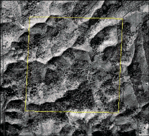

Figure 9. Study area 2 on the Landsat TM image from 1998 (T3) (top left and right), and on an aerial photograph from 1982 (lower left) and 1996 (lower right).
Compared to study area 1, study area 2 was less complex. Except for small patches of remaining forest the land was mostly open or in different stages of fallow. There were also signs that land was being used for grazing. Broad-leaved evergreen trees dominated the forested parts. Furthermore, an extended network of tractor roads was found on the site.
When studying the two aerial photographs in figure 7, it is evident that deforestation has occurred since 1982. It is difficult to tell only from aerial photograph what the actual land-use was at that time. Even though there was a lot more forest, there are signs of human impact and that clearing of forest has taken place.

Figure 10. A view from within study area 2.
West of the study area, the forest becomes denser. Still, there are plenty of open areas in a range of three kilometres from the site, which are a result of shifting cultivation. Eastwards, towards the village and down the valley, the land-use tends to be more dominated by permanent agriculture, e.g. paddy fields in valley bottoms.
The following species were identified as common forest species at study site no. 2:
Elaeocarpus sphaerieus Spondias pinnata
Schima wallichii Aromadendron elegans
Shorea roxburghii Alstonia scholaris
Diperocarpus alatus Vitex pinnata
Euginia cumini Terminalia bellerica
Helicia robusta Stereospermum neuranthum
Phyllanthus emblica Careya sphaerica
Nephelium hypoleucum Croton robusta
Cratoxylum spp. Annaslea fragrans
Sapium baccatum Garuga pinnata
Dillenia spp. Castanopsis spp.
Arthrocarpus lakoocha Lithocarpus spp.
Ficu spp. Quercus spp.
Schima Wallichii was commonly left standing as scattered trees on the fields.
Study area 2 was very different from the previous one. There was less presence of forestry officials due to the long distance to RFD offices. There was no national park in the vicinity, nor any special watershed protection programme. The information from Ban Khok is therefore predominantly given by villagers.
The villagers
The villagers use the land in the study area mainly for agriculture and grazing. Resin tapping and hunting are other forest activities. Forest products such as mushrooms, bamboo-shoots and wood for building materials are collected from the more dense and remote parts of the forest.
Agriculture
An example can be given of the crop-cycle in the study area:
Nine years ago the forest was converted to farmland and the owner planted ginger. After one year of
ginger, the crop was changed to upland rice for the following four years. Now the farmland has been in
fallow for five years. When will the owner return and start planting again? He will come back
to the land plot when he cant find other new land (farmer, Ban Kok).
Changing crops and opening new land is related to the poor soil fertility and the lack of inputs such as fertilisers. It is noted that ginger, in particular requires good soil. Burning is a used land preparation method. In Ban Khok only 20-30 families in the village cultivate fields on a permanent basis. With the new rural credit programme, people can borrow money to buy inputs such as chemical fertiliser. However, villagers claim that it is mostly the richest families who can afford these services.
Tenure
The tenure arrangement prevailing in Ban Khok is the Sor Tor Kor. This document states user-rights to agricultural land that cannot be sold, but can be passed on within families. All families have access to land under this tenure. By May 2000, about 40 households (20%) had obtained this document, and more will be allocated in the near future. The Land Department allocates 15 rai (2.4 ha) from degraded forest. The average size of land that a family actually utilises varies between 30-60 rai (4.8 ha). This means that households occupy more land than what is the formal tenure document. Farmland is often passed on to newly wed couples from respective parents. Otherwise, new land will be opened in the degraded forest.
In the study area there is an example of informal tenure. The bark of trees is marked in order to show that a person has taken claim to a field. Other people will have to respect this as an informal property right. This system of claiming land does not need to pass through the village Headman.

Figure 11. Picture of a tree that is marked indicating land claim
Village Headman
A village headman is elected by the residents of a respective village and will normally sit until the
age of 60. He is paid a small remuneration by the government (1000 Baht per month) in order to
participate in meetings in the sub-district office and serve as a liaison between the government and
the village. He acts as the spokesperson for the village as well as formally conveying decisions
taken at the District Office.
Cutting
When forest is cleared to open farmland, the tree species that are good for house-construction are used, while the rest is burned. Before the logging ban timber used to be sold to outsiders, but today this in not common.
Non wood forest products
In contrast to study area 1, people from other communities do not make use of the forest.
The forest products collected are: Mushrooms, bamboo- and young rattan shoots, chestnut fruit, palms, honey, resin to make torches, medicinal plants and sap to make glue. Wild lychee fruit is also harvested in the forest. Men hunt squirrels and birds.
During the rainy season, both women and men pick mushrooms. However, while women go out with the purpose of picking them, men do not. Men only pick mushrooms if they spot them on the way, as for example, when returning from the farmland. The harvest is for self-consumption, but if there is surplus, villagers go to the meeting point by the main road to sell.
A middleman buys chestnuts directly from the village, while palm-fruit and young rattan shoots the villagers themselves transport to the market in Dansai. A few families depend on resin tapping for making torches that are sold both in and outside the village.
There is one special bamboo shoot, which cannot be sold. The RFD permits it to be harvested only for village consumption.
Fuelwood:

Men are responsible for collecting fuelwood from the farmland. Charcoal is the most common heating source for cooking. For rice, that needs long cooking time, fuelwood is preferred. Gas is also utilised.
There is little presence of the RFD in the village and the office responsible for Ban Khok recently moved even further away. Visits are paid only occasionally and in specific periods, such as during the time of land preparation. People know that land clearing, even in degraded forest, is illegal and that it can lead to arrest.
The Rural Development Office supports projects in the village such as promoting rural credit, a housewife group, and construction of ponds for irrigation. For example, the rural credit fund permits villagers to take a loan of 10,000 Baht for pig and cattle raising, and 6,000 Baht for cultivation of banana. The loan has to be returned to a revolving fund within three years.
The findings of the RSS for study area 2 indicated that a change in land-use from long fallow to short fallow between 1991 (T2)-1998 (T3) had occurred.
Since aerial photographs from two dates were available for this site, it can be confirmed that there has been a change in the study area. With the information from the villagers at hand, there are reasons to believe that the major part of this change occurred after the T2 acquisition date.
Short fallow is the correct classification of the land cover today, which was also correctly interpreted in the T3 image. To prove that the classification of the T2 to be long fallow was correct, is naturally more difficult. The 1982 aerial photograph shows more of a closed forest, although parts are probably in fallow. Simply interpolating the two aerial photographs would result in the classification long fallow.
Assimilating the theory that the expansion of the land used for shifting cultivation is a continuos process westward, the interpretation looks even more reasonable.
To conclude, it seems most likely that the deforestation process is the strongest and will be prevailing in the near future. When they are forced to, people will change their practises. In this case, it might happen before in a smooth fashion, as there are already new alternatives being offered and facilitated.
Ban Nam Chuang Village, Chattrakarn District, Pitsanulok Province.
The village closest to study area 3 differed from the others since it was a hill-tribe community. This implies a different ethnic background. Their main language is not Thai and most of the inhabitants do not have citizenship. This was reflected in the headmans opening statements to the field-team: We do different agricultural practices from the lowlanders because we are not Thai but Hillside People. The people of Ban Nam Chuang village are of either White or Black Hmong ethnicity. In general, the culture is similar between the two. The minor differences are for example the traditional costume.
The Black Hmongs settled in the present location around 1910. Their previous settlement which was in a moist evergreen forest area six kilometres further north had to be left due to problems of malaria. The White Hmongs arrived at the site in 1982, when the government resettled them. Today there are 250 households with approximately 1300 family members. Presently, 59 families with 280 males and 228 females have been granted Thai citizenship.
During the 1970s, the political situation was tense in the region due to anti-government insurgency and the vicinity of the Laotian border. In addition, the establishment of the Phu Mieng Pho Troong Wildlife Sanctuary in 1979 provoked both political and ecological challenges. The government relocated people and put more resources into controlling the encroachment on the forest. Continued deforestation, suspicions of illegal cultivation and lack of citizenship continue to create conflicts.
Another Hmong village with a similar background, Ban Nam Khap, also lies within the Wildlife Sanctuary and is located about six kilometres from Ban Nam Chuan.
Citizenship and tribal people
In Thailand citizenship is not determined by place of birth, but by citizenship of the parents.
Citizenship rights for tribal people (either born in Thailand or otherwise eligible for citizenship) have been withheld due to local level corruption and a confusing array of sometimes contradictory laws...
It is estimated that 40 to 60 percent of the 834,000 tribal people living in Thailands mountainous borders do not have citizenship... without citizenship, highlanders are denied access to higher education, they cannot vote, highlanders can be denied employment, and can be exploited if they are hired. And without citizenship, highlanders can be denied access to land and resources... (Vaddhanaphuti C. & Aquino K., 2000 in Asia Pacific Community Forestry Newsletter, RECOFTC, 13 (1): 1, 14-15, 28).
The community is situated in a wildlife sanctuary, that includes the forested area of the districts Nam Pad, Thong Saeng Khan, Tron, Uttaradit and Chattrakarn, all in Pitsanulok Province.
No logging company has been active in the area. The closest concession was at Ban Non Thon in the lowlands about 20 years ago.
There are no special spiritual or an ancestral forest, but a village forest is preserved for harvesting palm leaves for roofing, mushrooms, and other food products.
The main source of livelihood in the Hmong village is agriculture. Cash crops such as ginger, cabbage, banana/sugarcane, cassava (fodder), upland rice, corn (fodder) and fruits are cultivated. There are around 300 cattle owned by the community that graze in the forest and on the fallows. The externally initiated projects in the village vary from reforestation activities to weaving. In February 2000, a dam project was completed that will be used for irrigation of farmland and for fish farming. There is no electricity in the village, but a project is supporting experiments with solar panels to charge batteries.
Out of the three sited studied, study area 3 had most evident signs of deforestation. The interpretation result was a change from closed forest to other land from 1991-1998. The cleared part can be seen south of the study area in figure 9. Further south a patch of dense forest (village forest) can be seen which has remained more or less untouched during the past ten years. Furthermore, there seems to be an area where the forest has recovered (positive change) along the road coming up to the valley.


Figure 13. Study area 3 on the Landsat TM image from 1998 (T3) (top left and right). The aerial photographs from 1976 (lower left) and 1996 (lower right). The aerial photographs were not geo- referenced and do not show exactly the study area.
The landscape was heavily deforested and the land use was shifting cultivation. Small areas seemed to be currently used for crops, indicating long rotation period. There were signs of frequent burning. Cattle were seen grazing. The area was accessible with several tractor roads.
Trees outside forest were observed, mainly the Kor palm (Livistona speciosa). Tree plantations of broadleaved species were Pterocarpus macrocarpus, Melia azedarach and Afzelia xylocarpa were also registered.
The observations made in the remote sensing study of the dense patch of forest could be confirmed to be dense evergreen forest (actually, it was the village forest). The indicated positive change of vegetation cover was more difficult to confirm, although the major impression was that there was less activity in that area.
The use of the aerial photographs was limited because they could not be referenced to the co-ordinate system. Anyhow, some interesting facts could be extracted; first, they show a quite intense deforestation in the area since 1976, when the forest was less disturbed. Second, in the photograph from 1996 there are no roads or tracks in the vicinity of the one square kilometre study area, which means that they were built during the past five years.

Figure 14. A view from the road coming up to study area 3. The heading of the picture is north and the edge of the forest seen is approximately where the boundary of the change polygon has been drawn.
The stakeholders identified were the villagers, the RFD Forest Protection Unit, the RFD Wildlife Sanctuary Unit, projects and lowland people11.
The most important interests of villagers in the study area are agriculture and grazing. Agricultural activities have been summarised in the table below:
Table 3. Agricultural calendar
Products |
When sow |
When harvest |
Market |
Household consumption |
Ginger |
March/April |
August/October (depends on market price) Otherwise wait until December/January |
x |
|
Cabbage |
Any time, but after 75 days |
Highest price in July/August because the lowlander's do not grow it during this time |
x |
|
Banana/sugarcane |
March |
October/ November |
x | |
Cassava (fodder) |
March April, anytime |
January/ February |
x |
|
Rice (upland) |
May June |
October/ November |
x | |
Corn |
May/April |
August/ September |
x |
|
Bamboo |
March April |
After being planted, it takes three years until they produce young shoots ( July/August) |
still experiment |
|
Jackfruit, mango, coconut, Lychee (expected future market) |
house/farmland |
x |
Bearing in mind the market fluctuations, an example of a crop-cycle can be as follows: Ginger and cabbage will be grown the first year and rice in the second. Cassava is the crop of the third and last year. The following fallow period is normally 4-5 years. Villagers started cultivating ginger approximately ten years ago. Today it is a dominant crop.
If offered a good price, products are sold to middlemen coming to the village. Otherwise, products are brought to the market in Lomsak, which takes 2-3 hours of driving.
Tenure
Until now, fifty households of Ban Nam Chuang have benefited by obtaining the user rights of 15 rai (2.4 ha) for farming provided by the Development Project for Security. This land allocation is from degraded forest. Since households need more land, forest encroachment continues. The project staff is aware of this, and a request will be made to get more land from the Ministry of Agriculture. The land is only allocated, without any guarantee of permanent ownership.
Forest Products
The Hmongs collect a lot of forest products from the village forest, Pah Huay Kor12, such as palm leaves used for roofing, young rattan- and bamboo shoots, mushrooms, forest vegetables and medicinal plants. The river, that is a source of drinking water, also originates in this forest. Around 1990 the villagers agreed on not to cut trees and encroach in the village forest13. Due to restrictions on marketing of products from a wildlife sanctuary, forest products can only be extracted for self-consumption. This is controlled by RFD checkpoints further down in the valley.
According to the assistant headman of the village, construction wood is cut on farmland. It may take several years to collect sufficient for a house. The preferred species for houseconstruction (Teak (Tectona grandis), Pterocarpus macrocarpus, Hopea odorata and Afzelia xylocarpa) are becoming increasingly scarce.
The unit has an office in the village. The main responsibility of the RFD Protection Unit entails patrolling to prevent illegal activities and to promote reforestation. In total, an area of 5,872 ha (36,700 rai) is planned reforested in the degraded areas of the wildlife sanctuary. The Protection Unit works in co-operation with the Wildlife Unit.
Illegal cutting
Villagers can be arrested for any agricultural practices on farmland exceeding the allocated 15 rai.
All cutting is illegal.
An example stated by RFD: There is a problem of a system for early warning of walkie-talkies.
These are used to warn against patrols in order to avoid arrest for illegal activities. The villagers in
both Ban Nam Chuang and Ban Nam Kaph have more than ten walkie-talkies in each village. They
know how to tune into the RFD wave-line. Although we try to avoid sending out sensitive messages,
the villagers are very updated on the RFD patrolling movements. People have time to warn each
other of our movements due to the geographic location of the two villages. The patrolling cars pass
by Ban Nam Kaph first (below the RFD office), before they continue towards the RFD office
heading towards Ban Nam Chuang village.

Figure 15. The RFD patrol car after an arrest
The Phu Mieng Pho Troong Wildlife Sanctuary covers an area of approximately 400,000 rai and was established in 1979. Originally, 16,000 ha (10,000 rai) was set aside for agricultural activity for the two villages. Since then, this area has quadrupled in size due to illegal shifting cultivation.
A wildlife sanctuary, per definition, should have a healthy forest with a lot of wildlife. Research is permitted, but neither collection of non-wood forest products nor tourism is allowed. The wildlife is decreasing rapidly, but illegal hunting is still frequent.
Besides the Development Project for Security mentioned in connection with land allocation, examples of projects operating in the village were many: The Royal project for hill-tribes that educates in weaving and embroidering, the Raja Put Foundation that conducts tree planting, and RFD reforestation of 21 degraded sites within the Wildlife Sanctuary. However, various problems, such as burning of seedlings, have been reported. In addition in February 2000 a large dam for irrigation was completed to promote permanent agriculture and aquaculture for the two villages.
The RSS classified the vegetation change from T2 to T3 as being a change from closed forest to other land use.
In this study area, there was less input from interviews about the interpreted change. From the visit to the study area it can be stated that the correct remote sensing classification is long fallow, since shifting cultivation is the dominating land use. The classification other land was not correct.
What about 1991 (T2 acquisition date)? The aerial photograph from 1996 shows that the major part of the deforestation had occurred already then. From the T2 satellite image we can clearly see spectral and textural difference between the adjacent dense evergreen in the study area. Still, compared to the valley further south there was certainly more vegetation.
The complicated political situation has traceable consequences in the land use, e.g, relocation of people. The change of area for cultivation activities might be explained by ordinary shifting cultivation land use pattern. A third explanation given was that this was due to the fact that land used to be utilised by lowland Thai people. They changed the area of activity according to new governmental directives.
The resettlement of people 1986, naturally increased the pressure on the land, and is a contributing factor for a significant change during the last decade.
To summarise, it is clear that there were too many data collection obstacles to get a full picture of the change that the land had undergone. Consequently, a reliable answer for whether there was closed, open forest or some early stage of shifting cultivation ten years ago, can not be given.
Table 4. Comparison of results from the three study areas.
Process/ factor |
Study area 1 |
Study area 2 |
Study area 3 |
Tenure rights |
Yes, but not formalised |
Informally agreed upon |
Slight |
Shifting cultivation methods |
Not any more |
Yes |
Yes |
Permanent agriculture |
Yes, dominating |
Slight |
No |
Population increase |
Fast |
Slow |
Fast |
Level of official presence |
High |
Low |
High |
Utilisation of NWFP |
High |
High |
Lower |
Utilisation of WFP |
High |
High |
High |
Dependency on agricultural products |
High |
Very high |
Very high |
Availability of sources of income |
Yes |
Some |
Few |
Forest Cover Change (T2-T3) |
Probably No |
Yes |
Probably Yes |
1 -making. In the 1997 Constitution, Art. 45 vests traditional communities the right and duty to manage resources (Poffenberger, 1999).
2 This is referred to as Channot ti din and is only found in the most developed parts of Thailand and accounts for relative small proportion of the land of the country (source: www.ethailand.com/business...estate/underst_land_titles/).
3 For example, Nor Sor 3, Sor Kor and Por Bor Tor 5.
4 The study team had access to locally produced document by a teacher about the village history and area
5 Other land refers to land classification for FRA 2000 (FRA Working Paper 1)
6 Closed forest refers to land classification for FRA 2000 (FRA Working Paper 1)
7 We were not able to conduct interview with the Poor People Federation (NGO). This is an NGO in the village that has been involved in the community forestry.
8 In the village, a focus group defined poor as those who were landless.
9 who would otherwise not afford to buy wood from the Sawmill in Chum Pae
10 One villager was 14 years old at the time and was paid between 8-12 Baht a day for taking care of the elephants.
11 Interviews with projects or lowlanders did not take place. However, signposts in Thai were advertising environmental protection of the watershed.
12 Pah= forest, Huay= stream and Kor= palm (Livistona speciosa)
13 The local RFD officer was not aware of existing rules for the Village Forest
