![]()
![]()
![]()
Are floods caused by nature or by human activities? This question has been posed for decades and the issue has been researched and discussed extensively in scientific circles. Surprisingly, in many countries sound science has had relatively little impact on people’s perceptions and beliefs. Partly, this is because the general public finds it difficult to distinguish between good and poor science, or between facts and plausible fiction. It may also be that some people find it more convenient or advantageous to perpetuate certain myths, rather than to address the issues in a sound, scientific framework. Hamilton (1985) has characterised this situation as ‘The 4 Ms: myth, misunderstanding, misinterpretation, and misinformation.’
Although a great deal is known about hydrological processes and the relationship between forests and floods, this knowledge is often used to make generalisations that are frequently inappropriate or misleading. There is a propensity to rely on simple cause-effect relationships, when in reality natural environments are extremely complex. Such complexity and the overlapping influences of human activities on hydrological systems are frequently oversimplified, particularly by the media and public officials seeking simple explanations and solutions. Moreover, the inherent uncertainties of many scientific findings and the absence of long-term research are downplayed. Little distinction is made between what we know, what we think we know or what we want to believe, contributing substantially to the general confusion surrounding the effects of forests on major floods. Also, while the hydrological processes are well-established, the site-specific nature of the many interactions leads to uncertainty in generalisations.
Much of this confusion has a long history and relates to the so-called 'sponge theory'. Although the exact origin of the theory is unclear, it appears to have been developed by European foresters at the end of the 19th century. While it has never been confirmed, many people have found it agrees with their own professional understanding and intuition. According to the theory, the complex of forest soil, roots and litter acts as a giant sponge, soaking up water during rainy spells and releasing it evenly during dry periods, when the water is most needed. Although the theory came under criticism as early as the 1920s, it continues to appeal to many people (foresters and non-foresters alike). In many countries, it is firmly embedded in national forest policies and programmes. The question is how much of the sponge theory is fact and how much is fiction?
|
An early American view on forests and floods Rain which falls over a bare slope acts differently. It is not caught by the crowns nor held by the floor, nor is its flow into the streams hindered by the timber and the fallen waste from the trees. It does not sink into the ground more than half as readily as in the forest, as experiments have shown. The result is that a great deal of water reaches the streams in a short time, which is the reason why floods occur. It is therefore true that forests tend to prevent floods. But this good influence [of forests on floods] is important only when the forest covers a large part of the drainage basin of the stream. Even then the forest may not prevent floods altogether. The forest floor, which has more to do with the fallen rain water than any other part of the forest, can affect its flow only so long as it has not taken up all the water it can hold. That which falls after the forest floor is saturated runs into the streams almost as fast as it would over bare ground. From: Gifford Pinchot, A Primer for Forestry, 1905 The Himalayan sponge The Himalayan forests normally exert a sponge effect, soaking up abundant rainfall and storing it before releasing it in regular amounts over an extended period. When the forest is cleared, rivers turn muddy and swollen during the wet season, before shrinking during drier periods. From: Myers 1986 |
Forests, regulation of stream flow and flood prevention
It is commonly believed that forests are necessary to regulate stream flow and reduce runoff, and to some extent this is true. But, in reality, forests tend to be rather extravagant users of water, which is contradictory to earlier thinking (FAO 2003). Considerable quantities of rainfall (up to 35 per cent) are commonly intercepted by the canopies of tropical forests and evaporated back into the atmosphere without contributing to soil water reserves. Much of the water that does soak into the soil is used by the trees themselves. This should put to rest the belief that extensive reforestation or afforestation will increase the low flows in the dry season (Hamilton and Pearce 1987). Therefore, replacing forest cover with other land uses almost always results in increased runoff and stream flow. Runoff and stream-flow patterns will gradually return to original levels if an area is left to revert back to forest. Converting forest to grasslands, however, will normally result in a permanent increase in total water runoff.
Contrary to popular belief, forests have only a limited influence on major downstream flooding, especially large-scale events. It is correct that on a local scale forests and forest soils are capable of reducing runoff, generally as the result of enhanced infiltration and storage capacities. But this holds true only for small-scale rainfall events, which are not responsible for severe flooding in downstream areas. During a major rainfall event (like those that result in massive flooding), especially after prolonged periods of preceding rainfall, the forest soil becomes saturated and water no longer filters into the soil but instead runs off along the soil surface.
Studies in America (Hewlett and Helvey 1970), and South Africa (Hewlett and Bosch 1984) were amongst some of the first to question the importance of the link between forest conversion and flooding. Studies in the Himalayas indicate that the increase in infiltration capacity of forested lands over non-forested lands is insufficient to influence major downstream flooding events (Gilmour et al. 1987; Hamilton 1987). Instead, the main factors influencing major flooding given a large rainfall event, are: (i) the geomorphology of the area; and (ii) preceding rainfall (Bruijnzeel 1990, 2004; Calder 2000; Hamilton with King 1983; Kattelmann 1987).
|
Yielding insights into water yields No experiments, with the exception of perhaps one, have resulted in reductions in water yield with reductions in cover, or increases in yield, with increase in cover. From: Bosch and Hewlett 1982 |
Even at the local level, the regulating effect depends mostly on soil depth, structure and degree of previous saturation. Thin soils produce ‘flashy’ flows (quick responses). Massive programmes of forestation that have often been proclaimed as ‘the answer’ to preventing floods simply will not do the job, although there may be many other benefits from reforestation (Hamilton and Pearce 1987).
Erosion and sedimentation
It is widely perceived that forests can control erosion and sediment processes. While forest cover does tend to check erosion, it is not the tree canopy that is directly responsible for this; rather it is the undergrowth and forest litter. Experiments indicate that the erosive power of raindrops under trees actually tends to be very high because the raindrops merge before dripping off the leaves and therefore hit the ground with greater force (Wiersum 1985; Hamilton 1987; Brandt 1988). This sometimes leads to particularly serious erosion problems in plantations where the soil has been cleared of vegetation and litter to reduce fire hazard or where litter is collected for livestock bedding or fuel. If the soil surface is adequately protected by a well-developed litter layer and complete vegetative cover, other vegetation types can offer equivalent protection against erosion, but with the added advantage of lower water use.
Land degradation and soil erosion that are often associated with the loss of forest cover are not necessarily the result of the forest removal itself, but of the poor land-use practices (overgrazing, litter removal, destruction of the organic matter, clean weeding) implemented after forest removal (Bruijnzeel 1991, 2004; Hamilton with King 1983). Also, much of the erosion that occurs after timber harvesting is due to the movement of soil during logging operations (e.g., road construction, skidding, etc.). Compaction results in lower water storage capacity of the soil and increased surface runoff. Many of these negative effects can be significantly diminished by applying reduced impact logging (RIL) techniques.
|
Environmental benefits of reduced impact logging (RIL)
From: Killmann et al. 2002 |
Landslips, too, may occur due to the loss of forest cover. Tree roots play an important role in slope stability and can indeed give the soil a certain amount of mechanical support, but this is limited to shallow (<1m) mass movements (Bruijnzeel 1990, 2002; O’Loughlin 1974). This type of landslide is quickly stabilised and does not usually result in high amounts of sediment entering the surrounding rivers. Deep-seated (>3m) landslides, on the other hand, are not noticeably influenced by the presence or absence of a well-developed forest cover (Bruijnzeel 1990, 2002). Such events are most influenced by geological, topographical and climatic factors, rather than by forest cover (Ramsay 1987).
Impacts of scale on flooding
Research on the effects of land-use changes on flooding is usually conducted in small headwater catchment areas (e.g., 100-1,000 hectares) and frequently considers the effects of only a single change in vegetative cover (e.g., from forest to grassland), such as the landmark Coweeta experiments in the United States (Douglass and Swank 1975). Such experiments do not adequately take into account the multiple land uses found over entire watersheds. Therefore, extrapolation of research results obtained in sub-watershed areas to entire watersheds is inappropriate and misleading. A review of past research indicates that land-use effects on flooding were observable only in relatively small basins (Table 1). In basins larger than 50,000 hectares, the effects of flooding tend to be averaged out across the different sub-basins as storms pass over. Since the flood waves from the different sub-basins do not usually reach the main basin area simultaneously, there may be little or no cumulative effect from the individual flood waves.
|
Experts agreeing on what is needed Much is known about hydrological processes in forests at a small catchment scale. However, there is a critical need to initiate and strengthen long-term eco-hydrological monitoring for further research to improve understanding of large-scale interactions and the influence of forests on dry season flows, flood mitigation and groundwater recharge in a range of environments in line with paragraph 27 of the WSSD Plan of Implementation. From: Shiga Declaration on Forests and Water, 2002 |
When major floods do occur, it is most often towards the end of the rainy season, when heavy rain falls in a number of sub-basins (simultaneously) and usually on soils that are already saturated and therefore incapable of soaking up additional water. The extent and severity of wide-scale flooding can be further intensified by the occurrence of torrential rains in the floodplains or the river surfaces themselves during vulnerable periods. This can be further exacerbated by high tides, which frequently happen in Bangkok, Dhaka and other low-lying cities.
Table 1: The spatial dimension of land-use effects
|
Impact |
Basin size [km2] |
||||||
|
|
0.1 |
1 |
10 |
100 |
1000 |
10.000 |
100.000 |
|
Average flow |
x |
x |
x |
x |
- |
- |
- |
|
Peak flow |
x |
x |
x |
x |
- |
- |
- |
|
Base flow |
x |
x |
x |
x |
- |
- |
- |
|
Groundwater recharge |
x |
x |
x |
x |
- |
- |
- |
|
Sediment load |
x |
x |
x |
x |
- |
- |
- |
|
Nutrients |
x |
x |
x |
x |
x |
- |
- |
|
Organic matter |
x |
x |
x |
x |
- |
- |
- |
|
Pathogens |
x |
x |
x |
- |
- |
- |
- |
|
Salinity |
x |
x |
x |
x |
x |
x |
x |
|
Pesticides |
x |
x |
x |
x |
x |
x |
x |
|
Heavy metals |
x |
x |
x |
x |
x |
x |
x |
|
Thermal regime |
x |
x |
- |
- |
- |
- |
- |
Legend: x = Observable impact; - = no observable impact
Adapted from Kiersch (2001).
Frequency of floods
Although some studies have shown apparent increases in flooding over time, such studies have tended to look at relatively short timeframes and limited data sets (Bruijnzeel 1990). When considering longer timeframes, cycles are revealed within which major flooding tends to occur at fairly regular intervals. These cycles appear to be driven by major climatic patterns (e.g., those resulting from the influence of cyclical warm ocean currents).
Examining the historical patterns of catastrophic events reveals that floods, as well as droughts, are not a recent phenomenon by any means. For example, major floods in the Bangkok metropolitan and adjacent areas have been recorded regularly for the last 200 years. Large-scale floods in the Chiang Mai valley in northern Thailand are well documented for events in 1918-1920 and again in 1953. These floods all occurred when lush forests were still abundant in Thailand. Eight major floods were recorded in Bangladesh between 1870 and 1922. A study on floods in Bangladesh concluded that 'there is absolutely no statistical evidence that the frequency of major flooding has increased over the last 120 years' (Hofer and Messerli 1997).
Perceptions of the destructive power and severity of floods
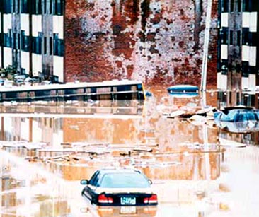
Settlements have always been established on floodplains, despite the risk of periodic flooding. The numerous social, economic and environmental benefits of living near water have historically outweighed the risks of floods. Most early settlements were located on the higher areas of floodplains, which helped to minimise risks and potential damage from floods. As towns and cities grew, however, new housing areas and commercial estates expanded into the more flood-prone areas that had previously been avoided.
The development of urban areas also transformed formerly vegetated land to impermeable surfaces, with little or no water storage capacity. Extensive areas of wetlands that once acted as natural retention and storage areas for floodwaters were drained, filled and built upon. Natural stream channels were straightened and deepened, and structures such as dams and embankments were commonly built to reduce local flood risks.
These 'solutions' may have served to help reduce flood impacts locally but have often had the effect of shifting the problem further downstream, rather than solving it. This pattern has been exacerbated by the removal of the natural storage functions of the floodplain. Today’s floodplains bear little resemblance to yesterday’s floodplains, and it should not be a surprise therefore that even minor floods can nowadays cause major damage.
The severity of floods is often measured and described in terms of economic losses rather than physical parameters. This approach can easily give the impression that flooding has become much more severe in recent times. In reality, the huge economic losses attributed to flooding in recent years are mainly a reflection of expanding economic growth, increased investment in infrastructure and rapidly growing floodplain populations. Although the escalating economic costs of floods underscore the urgent need for improved floodplain management and disaster mitigation, it is incorrect to conclude that floods are any more frequent (in physical terms) now than in the past.
|
Recognising the dilemma! Within river systems, flooding is the natural way for the system to discharge the water arising from the occasional large rainfall event. There is no problem at all until man decides to use some of the natural flood plain for his own use, and chooses to protect against inundation. We then face the dilemma of protecting against a natural hazard for the benefit of mankind that has chosen to live and work in flood plain areas. From: Learning to live with rivers, Institute of Civil Engineers, 2001 |
Although humans do not directly cause floods, we have sometimes greatly exacerbated the problems caused by floods. Not only do many cities have inefficient water-drainage systems, local land subsidence makes recent floods appear worse than past events. For example, due to excessive and long-term groundwater withdrawal, Bangkok is sinking at an average of 2 cm every year. Since the city’s elevation is between 0 and 1.5 m above sea level, it is not surprising that high tides can inundate major parts of the city, especially when they coincide with heavy rains. Other cities suffer similar problems. Moreover, the large increase in non-absorbing surfaces that goes with urban growth exacerbates the problem, speeding surface runoff, and allowing less infiltration.
|
Going under Pumping of groundwater is one of the main causes for land subsidence, which has resulted in deeper flooding and longer water logging. From: Pramote Maiklad 1999 |
The media also plays a significant role in shaping perceptions of the intensity, frequency and severity of flooding. Modern television news networks, in particular, can record and broadcast news of catastrophes far more quickly and comprehensively than anytime in history. While major flooding events of the past often went completely unreported, or were described only sketchily, perhaps months after their occurrence, modern media has the capacity to report extensively on flood disasters occurring anywhere in the world within hours. This capacity of the media, coupled with journalists’ penchant for sensationalising news events - particularly disasters - can easily lead people to conclude that floods are occurring more frequently and with greater severity than in the past. Scientific evidence, however, does not support such conclusions.
For intensively developed urban areas and floodplains, land-use planning and control measures have an important role to play in flood mitigation (Moosan City, Kyungkido Province, Republic of Korea) (courtesy of the Farmland Rearrangement Division, Ministry of Agriculture and Forestry, Republic of Korea through Water Resources Section, UNESCAP)
![]()
![]()
![]()