


In the context of Earth observation remote sensing, an image is generally a picture received from a satellite or an airborne sensor. Digital images from satellite remote sensing are useful for fire monitoring because they:
• Allow low cost, rapid and regular coverage of the often extensive and inaccessible areas affected by fire.
• Permit capture of types of data that humans cannot sense, such as the near-infrared and thermal part of the electromagnetic spectrum, which may provide additional useful information.
Here we briefly introduce the general characteristics of digital images, mostly from space borne sensors, as a potential source of information for fire management. As different sensors provide images with different characteristics, we focus on criteria commonly used to evaluate and compare imagery from different sources.
Remote sensing data can assist fire management at three stages relative to fire occurrence:
(i) Before the fire: vegetation biomass, vegetation status and rainfall; monitoring pre-suppression / fire prevention measures;
(ii) During the fire: near real-time location of active fires;
(iii) After the fire: assessment of burned areas.
5.2.1 Active Fires
Active fires can be detected from satellite data because fire fronts are very hot and emit large amount of energy that can be observed by thermal sensors on board satellites or aeroplanes. The identification of fires in an image is now relatively well mastered, and remaining limitations are mostly due to the sensor in itself.
Active fire product in fire management
Once integrated into a fire information system, the list of fire locations can be used in two main ways:
a) In near-real time, to prioritise resources for fire fighting. Fire locations can also be used, on a daily basis, to monitor for example that planned prescribed burning is actually taking place.
b) As post-fire information, the active fire product can be used in several ways. First it can support a policing role. Secondly, active fire products can be used to document fire activity in a park, over a municipality or over a whole country. It may further document the extent of individual fire fronts and the size of fires that contribute to the burned area mosaic.
Operational active fire products
There are a number of satellite and airborne remote sensing systems which can contribute to fire monitoring from space, including NOAA AVHRR, Landsat TM and MSS, SPOT, GOES, DMSP, ERS-ATSR, and JERS.
High spatial resolution satellites, such as Landsat and SPOT, can contribute to fire monitoring, but their cost, their centralized receiving stations and especially their low temporal resolution, limit their use on an operational basis. Meteorological satellites are more appropriate because of their high repetition coverage. The Meteosat geostationary satellite series cover Africa and Europe, and provide images every 30 minutes (Meteosat Second Generation satellite is providing an image every 15 minutes, with improved channels for fire information). The polar orbiting NOAA series acquires images over the same area every 12 hours by the same satellite, and cover the entire world.
There are several points that are important to take into account when interpreting and using active fire products from AVHRR data. Most of them are linked to the intrinsic characteristics of the satellite platform and its sensor. Detection algorithms are usually set to minimize the number of false detections. Consequently, some fires will also be missed.
Burned area product principles
Burned areas are detected from remotely sensed data based on three main changes in surface properties following fire:
• Vegetation is removed.
• Combustion residues are deposited.
• During the day, the burned surface is hotter than surrounding vegetation, with a maximum contrast in temperature occurring around mid-day.
Burned area products in fire management
Integrated into a Fire Management Information System, burned area products are useful at all stages of the fire management loop:
Baseline Data
Burned area products can provide important baseline information on fire regimes (i.e. frequency, season and intensity). Fire frequency maps are obtained by superimposing burned area maps for successive years. Seasonal fire maps are produced using a number of successive burned area products.
Fire management
Both the block and patch-mosaic methods of prescribed burning require accurate records of burns in order to help plan ignitions. Mapping burned areas as the season progresses also allows areas that burn naturally to be incorporated into ignitions planning. Burned areas products can also be of value to fire suppression teams.
Monitoring and evaluation of management activities
The products can also help to answer management evaluation questions such as: How well did management fire lines stop fires (i.e. by overlay of burned areas and fire lines); have management efforts reduced the areas that burn each year; or - more generally - how well are desired fire regimes realised?
Refining Policy
All the data above are then used to refine fire management policies. Fire frequency maps can also help identify areas where high intensity fires are burning frequently, as foci for field visits to investigate the causes and fire effects.
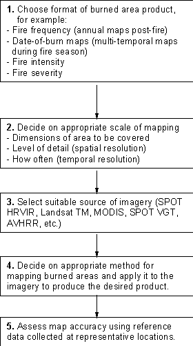
Figure 1. Flow diagram showing the main steps and considerations in the preparation of burned area products.
5.2.3 Rainfall Estimation
Derivation of Rainfall Estimates
Rainfall is normally measured using rain gauges. However, the network of rain gauges may be sparse in those areas affected by fire. Satellite observations are used in combination with, and to augment, rain gauge data. Satellite data provide a spatially complete, uniformly distributed coverage that allows better estimation of rainfall where rain gauges are infrequently and irregularly sited.
Rainfall Data in Fire Information Systems
Rainfall estimations can be produced for finely gridded areas, e.g. 5 x 5 km areas, but are often used as summaries over political or physical regions, for example, countries or catchments. Statistics can include total, mean and standard deviation of rainfall in millimetres, area of rainfall coverage within a region, etc. The rainfall data can be combined with other data to produce further information, for example, hydrological modelling or a fire information system.
Rainfall maps can be used to inform management, for example, a recent rainfall could to be taken into account when deciding on the timing of prescribed burns. Rainfall estimation can also be integrated with other data, for example, as an input to fire risk assessment. The rainfall information is incorporated in estimation of vegetation moisture content, which can then be combined with fuel data for assessing fire risk.
Data produced by any remote sensing activities should be integrated into a Fire Management Information System so that, through the combination of data from various sources, more information can be extracted to better support management decision-making.
A range of situations could occur, and some fire management teams may have access to their own remote sensing group or government-run remote sensing resources. Many others may find some existing local expertise in remote sensing, e.g., a local consultancy, scientific institute or university, who could assist in the setting up of a remote sensing group, provide training or even be contracted to do the work.
The following are some considerations for those who want to set up and run a remote sensing component for fire monitoring and management.
The person running the component should have a combination of remote sensing skills and field experience (perhaps in fire or vegetation ecology), or at least demonstrated aptitude and a willingness to learn new skills. He or she, should have some input to the design of a remote sensing strategy; should decide which imagery will be used to obtain the information, and how often, and choose and implement the methods to extract information. The person should make every effort to assure quality control at all stages, including assessing the accuracy of final products wherever possible.
Access to relevant information
Staff should ideally have access to publications on remote sensing, land mapping, fire ecology and other relevant information. Easy access to up-to-date literature is especially helpful in selecting appropriate methods to deliver particular information products and in avoiding common mistakes. Collaborative research with local and international scientific institutions can also help in product development.
For in-house remote sensing clearly office space is required, and adequate remote sensing hardware and software must be acquired. Image processing and Geographic Information System (GIS) tools allow a fire information system to be built up with the objective of supporting operational fire management.
Adequate Budget to Maintain the Information System
As well as personnel and initial set up costs for hardware and software, the budget should include allocations for recurrent expenses, such as image data costs and additional data acquisition. Maintenance and upgrade costs for hardware and software, and replacement of consumables, must be considered too. Fieldwork is necessary to validate remote sensing outputs, so a budget for transport (and maybe equipment) should be available. Hence, budget constraints are very important in developing an operational remote sensing strategy.
