![]()
![]()
![]()
Technical papers
Jayampathy Samarakoon1
“Building back better” by incorporating sound integrated coastal planning and management (ICM) has been beset with contradictions since the tsunami of 26 December 2004. Low-cost programmes on how to save lives are being ignored at vulnerable locations, particularly in Indonesia. This is evidenced by the tsunami of 17 July 2006 which killed about 600 people in Java. Adding to existing contradictions, the complexity of the task has been increased by tensions among coastal land uses during the past decade. Tensions stem mainly from the magnitude of financial investments and political power driving change. Small-scale artisanal fisherfolk and farmers were the worst affected by the tsunami but are also the poorest and least powerful except where they are well-organized, as in Kerala. The general absence of tenure and property rights with legal forms of representation is a major obstacle faced by coastal resource users because they are dependent mainly on customary rights. Failure to safeguard livelihoods and diminishing income from natural resources is driving increasing numbers of these unskilled and semi-skilled workers to foreign employment, particularly from Bangladesh, India and Sri Lanka where most of the coastal poor live. A “remittance windfall” has resulted despite governance failure. ICM in the post-tsunami era needs to entrench governance, community, ecology, science and market aspects more firmly while enhancing opportunities for the coastal poor. Carefully designed tenure rights are an instrument that can provide cohesion and political power to enable negotiation for improved governance.
This section is long due the multidisciplinary theme of this paper. The objective is to clarify significant factors that have contributed to the relationships among land use, poverty and the environment during the past decade and their implications for ICM in post-tsunami reconstruction.
1.1 Structure of the paper
This paper was prepared for the FAO workshop on Coastal Area Planning and Management in Asian Tsunami-affected Countries, held from 27 to 29 September, 2006 in Bangkok, Thailand. The workshop proposed that sound coastal area planning and management constituting ICM are key factors that influence the success and long-term sustainability of rehabilitation and reconstruction in areas affected by the 2004 Indian Ocean tsunami.
The paper is divided into four sections:
Section 1 provides a sense of the complexity of the subject matter; the challenge posed by a natural disaster to a government; the diversity of coastal resources, their significance and some political aspects; the limitations of ICM in addressing problems related to poverty and land tenure; and market liberalization and globalization, which have induced change in attitudes and values at an accelerating rate at the national level.
Section 2 reviews land uses and trends that influence coastal communities, livelihoods and the environment. It also examines some aspects of land and resource tenure, mainly with a view to bringing out the relationship between financial and political power and the livelihoods of the poor.
Section 3 provides six indicative case histories. They are presented and analysed to demonstrate the influence of decisive factors.
Section 4 presents general conclusions and lessons derived from case histories.
1.2 Tsunami impact and government responsibility
“A natural catastrophe on national territory confronts a country with its deepest identity, with its capacities for technical and social response” (Todd 2005). The Asian tsunami was generated by a megathrust earthquake measuring 9.4 on the Richter Scale, which occurred on 26 December 2004. Only strong physical structures and elevated landforms resisted the unrelenting advance of the earthquake-induced wall of water. In the vicinity of the earthquake epicentre, parts of the inhabited landmass subsided into the sea. In 30 minutes, across tsunami-affected Asia, about 280 000 people were killed or listed as missing and nearly two million were made homeless (Sieh 2006). Governments in the worst-affected countries were challenged to provide relief and subsequent reconstruction (Table 1).
Most of the people who died were the poor, fisherfolk, farmers and low-income coastal residents. They depended upon coastal resources for their livelihoods and thus lived near the shoreline. They resided in areas exposed to natural hazards and lived in flimsy houses (Sachs 2005). The magnitude of the damage also reflected the relatively high population concentrations. Impact in Bangladesh was minimal due to buffering by the Sunderbans mangroves on its macrotidal delta fronting the Bay of Bengal. Except where dense deltaic mangroves were located, it is unlikely that this vegetation in general saved lives (Baird 2006).
Experience has revealed that only governments have the resources to coordinate and implement relief and reconstruction efforts in response to a disaster on the scale of the Asian tsunami (ProVention Consortium 2004). Reconstruction may take many years before all victims obtain adequate relief. It must proceed within the existing framework of governmental activity. A government can provide policy, an institutional framework and guidelines to ensure the participation of all potential stakeholders and to ensure standards and fair distribution of entitlements. Ultimately, the goal is to provide a better quality of life for the victims of the disaster and to minimize future damage. ICM has a role to play both in planning and in implementation of reconstruction.
1.3 The role of ICM
ICM is a process that:
Unites government and the community, science and management, sectoral and public interests, and markets in preparing and implementing an integrated plan for the protection and development of coastal ecosystems and resources. The overall goal of ICM is to improve the quality of life of human communities who depend on coastal resources while maintaining the biological diversity and productivity of coastal ecosystems (GESAMP 1996).
The significance of ICM is influenced by, inter alia, geomorphology, dispersion of resources, the political system and demography. The Asian tsunami-affected countries share some common features while they differ markedly in others (Table 2). Government commitment to ICM is influenced both directly and indirectly by the characteristics of the coastal resources (Table 3). Coastal agriculture and forestry are significant in countries with fertile alluvial deltas. The potential for tourism is high where attractive beaches exist. Coastal fisheries are uniformly significant.
There were approximately 700 ICM initiatives worldwide in 2002 (Islam 2006). Some had been in operation for about two decades, as in Indonesia and in Sri Lanka and for shorter periods in India, Malaysia, and Thailand (Cicin-Sain and Knecht 1998). The effectiveness of ICM is associated with the manner in which it is integrated with the needs of a country or regional and local situations, including the basic parameters of coastal and marine ecosystems (White et al. 2005). The main thrust of discussion in the post-tsunami era is “build back better”.
Table 1. The distribution of impacts among the Asian countries (WHO 2005; various sources)
|
Country |
Area affected |
Damage |
Displaced |
Relief |
Injured |
Missing |
Deads |
Government response |
| B’desh | Not defined | -- | -- | -- | -- | -- | 2 | Not reported |
|
India |
2 200 km of coastal land; 300 m to 3 km inland and 3 million people |
897 villages, 157 393 dwelling units, 11 827 ha of cropped area, estimated at US$ 1.56 billion |
647 109 |
595 relief camps with 376 171 people, 646 256 people evacuated |
3 324 in Tamil Nadu only. N/A for other countries. Women affected more than men (Zachariah 2006) |
5 711 | 10 672 |
Relief and reconstruction by the Government of India, military mobilized |
|
Indonesia |
Aceh Districts (4 out of 21), 1 million people |
172 subdistricts, 1 550 villages, and 21 659 houses destroyed |
703 518 | -- |
1 443 hospitalized |
12 132 | 110 229 |
Major government effort supported by donors, military conflict in Aceh terminated |
|
Malaysia |
NW States of Penang and Kedah |
-- | 8 000 |
30 000 in 9 camps |
73 in-patients/694 out-patients |
6 | 68 |
All relief and reconstruction completed by the government in 2006 |
|
Maldives |
20 atolls |
100 000 people affected |
21 663 | -- | 2 214 | 21 | 81 |
Major island reconstruction undertaken with support from donors |
|
Myanmar |
10–15,000 affected, 5-7 000 directly affected |
592 houses of 17 villages destroyed |
3 205 homeless, households 638 |
-- | 43 | 3 | 59 | No information |
|
Sri Lanka |
Affected families: 103 789; houses 103 753 |
90 143 fully damaged houses, 41 622 partially damaged houses |
425 620 |
442 relief camps |
15 256 | 6 034 | 30 899 |
Government response ambivalent, voluntary and donor support major, response better in south than in east and north – more severely affected (World Bank 2007) |
|
Thailand |
6 provinces |
6.85 million baht committed on west coast for assistance |
-- |
47 708 rescued workers |
8 457 | 3 396 | 5 303 |
Relief & reconstruction mainly by government, tourism reviving rapidly |
Table 2. Selected geographic, demographic, socio-economic and political features of the Asian tsunami-affected countries showing differences among them (CIA world factbook: https://www.cia.gov/cia/publications/factbook/; UN Population Reference Bureau 2006)
|
Feature |
Country |
|||||||
|
Bangladesh |
India |
Indonesia |
Malaysia |
Maldives |
Myanmar |
Sri Lanka |
Thailand |
|
|
Land size (km2) |
144 000 | 3 287 590 | 1 919 440 | 329 750 | 300 | 678 500 | 65 610 | 514 000 |
|
Total population (thousands) |
147 365 | 1 095 351 | 245 452 | 24 385 | 359 | 47 382 | 20 222 | 64 631 |
|
Population growth rate (%) |
2.09 | 1.38 | 1.41 | 1.78 | 2.78 | 0.81 | 0.78 | 0.68 |
|
Infant mortality( per 1 000 live births) |
60.83 | 54.63 | 34.39 | 17.16 | 54.89 | 61.85 | 13.97 | 19.49 |
|
Life expectancy at birth (total, yrs) |
62.46 | 64.71 | 69.42 | 72.5 | 63.08 | 58.07 | 73.41 | 72.25 |
|
Ethnic composition (%) |
Bengali ( 98) |
Indo–Aryan (72); Draavidian (25) Mongoloid and other (3) |
Javanese (45); Sundanese (14); Madurese (7.5); coastal Malay (7.5); other |
Malay (50.4); Chinese (23.7); Indigenous (11); Indian (7.1); others |
South Indians; Sinhalese, Arabs |
Burman (68); Shan (9); Karen (7); Rakhine (4); Chinese (3); Mon (2); other |
Sinhala (73.6); Sri Lanka Moors (7.2); Indian Tamil (4.6); SL Tamils (12.7); others |
Thai (75); Chinese (14); other (11) |
|
Existence and severity of ethnic conflict |
Relatively minor in the hill tracts |
Relatively serious in Kashmir and Assam |
Serious in Aceh until 2004 |
Minor to moderate (?) |
None reported |
Reportedly serious |
Severe: 65 000 deaths and more than 500 000 displaced |
Moderate in the south |
|
Literacy (% total, age > 15) read and write |
43.1 | 59.5 | 87.9 | 88.7 | 97.2 | 85.3 | 92.3 | 92.6 |
|
GDP per capita (US$) |
2 100 | 3 400 | 3 600 | 12 000 | 3 900 | 1 700 | 4 300 | 8 600 |
|
% below poverty line |
45 | 25 | 16.7 | 8 | 21 | 25 | 22 | 10 |
|
Gini index (distribution of family income) |
31.8 | 32.5 | 34.3 | 49.2 | NA | NA | 34.4 | 51.15 |
| HDI | ||||||||
|
Foreign exchange reserves (US$ billion) |
2.825 | 136 | 34.58 | 70.23 | 763 million | 2.737 | 52.07 | |
|
Government type |
Parl’mentary democracy |
Federal republic |
Republic |
Constitutional monarchy |
Republic | Military junta | Republic |
Const’nal monarchy |
Table 3. Selected features of coastal resources: fisheries, agriculture and forestry in the Asian tsunami-affected countries http://earthtrends.wri.org/pdf_library/country_profiles/coa_cou_356.pdf ; https://www.cia.gov/cia/publications/factbook/ *
|
Feature |
Country |
|||||||
|
Bangladesh |
India |
Indonesia |
Malaysia |
Maldives |
Myanmar |
Sri Lanka |
Thailand |
|
|
Length of coastline (km) * |
580 | 7 100 | 54 716 | 4 675 | 644 | 1 930 | 1 340 | 3 219 |
|
% of population within 100 km of the coast |
55 | 26 | 96 | 98 | 100 | 49 | 81 | 39 |
|
Area of mangrove forest (km2) |
4 403 | 3 036 | 23 901 | 1 659 |
Negligible (Neg) |
Large scale—area not available |
87 (scattered patches) |
5 092 |
|
Whether supportive of mangrove-based forestry |
Yes | Yes | Yes | Yes | No | Yes | No | Slight |
|
% mangrove area protected |
8 | 50 | 33 | 7 | Neg | Not available | 9 | 5 |
|
Wetlands of international importance (km2) |
5 960 | 1 930 | 2 427 | 384 | Neg | Not available | 62 | 5 |
|
Annual fishery production in tonnes (excluding aquaculture) |
221 459 | 3 138 654 | 4 026 415 | 1 445 417 | 132 222 | 902 018 | 269 771 | 3 047 938 |
|
Aquaculture production in tonnes |
657 121 | 2 095 072 | 993 727 | 167 898 | Neg | 98 918 | 12 360 | 706 999 |
|
People employed in fishing and aquaculture |
1 320 480 | 5 958 744 | 5 118 571 | 100 666 | 19 108 | 610 000 | 146 188 | 354 495 |
|
Availability of deltas suitable for coastal agriculture (author’s opinion) |
Large scale | Moderate | Moderate | Moderate | Nil | Moderate | Nil | Moderate |
|
% people employed in fishing and aquaculture |
0.9 | 0.6 | 2.1 | 0.41 | 5.3 | 1.29 | 0.72 | 0.55 |
|
Agricultural workers as % of labour force |
65.2 | 64 | 55.2 | 27.3 | 32.3 | 73.3 | 48.5 | 64.1 |
|
% GDP from agriculture |
24.6 | 24.9 | 16.9 | 11.1 | Neg | Not available | 19.5 | 10.5 |
|
Forest as % total land area |
12 | 8 | 60 | 66 | Neg | 69 | 13 | 31 |
|
Average annual value of trade in forest products imports/exports ($) |
93 335/5 003 |
747 637/32 890 |
903 805/4 583 498 |
929 417/3 615 326 |
4 220/14 | 11 182/197 388 | 81 062/2 580 |
1 480 310/597 565 |
|
Availability of beaches for tourism (author’s opinion) |
Low | High | High | Moderate—high | High | Moderate | Moderate—high | High |
1.4 Poverty, economic growth, labour migration and remittances
The complexity of poverty is described extensively in the literature, for example: Human development reports (UNDP 1990–2005); Narayan and Petesch 2002; World Bank (2000 and various years). The relationships among development, poverty and equity are given in World Bank (2006). Poverty reduction is complex and uses diverse approaches (Carney et al. 1999). Sachs (2005) upholds the need for development assistance coupled with “central” planning and implementation. Easterly (2006) contends that centralized planning and development assistance cause poverty in the absence of appropriate incentives. However, all agree that economic growth is essential for poverty reduction. Contradictions emerge. Economic growth in South Asia and Indonesia (Table 2) has been relatively high. In parallel, migration of unskilled and semi-skilled labour to more prosperous economies such as the Gulf countries is increasing. About 40 percent of remittances in the Asia–Pacific region flowed into South Asia at an average annual rate of about US$10 billion from 1990 to 2004. Such remittances reduce household poverty, although their contribution to national economic growth is insignificant (Jongwanich 2007). Evidently economic growth by itself, if unaccompanied by distribution (equity), cannot reduce poverty.
Stern (2005) argues that development has to be seen as a process of dynamic change. During the last 20 years of a 50-year period of change in development, the number of people living below US$1.00/day fell by about 400 million people. Life expectancy increased from the mid-forties to the mid-sixties. Thirty years ago, half the population of the developing world was illiterate; now this has been reduced to a quarter. Many people, however, have been omitted, particularly in the most populous countries in tsunami-affected Asia: India, Indonesia and Bangladesh. The structure of the economy also has changed — a massive exodus from agriculture has occurred. The contribution from agricultural output had declined from 50 to around 25 percent. Twenty-five years ago, the proportion of people in urban areas in developing countries was around one-third or less. Twenty years from now, about half the developing world will be living in towns and cities (Stern 2005).
Development as a “process of dynamic change” requires convergence of (Stern 2005):
The former requires policies, governance and institutions that give confidence and enable people to allocate money and energy towards future betterment. The latter involves:
Stern (2005) asserts that two elements omitted from the aforesaid view of development were institutions and governance. Institutions have a range of definitions. For this overview the institutional aspects that are important are (Easterly 2002):
Thus poverty reduction has both macroeconomic and microeconomic implications. In the aforementioned perspective, the role of ICM in poverty reduction has to be assessed with caution because its geographic scope is highly limited and must integrate with wider relationships.
1.5 Globalization and market liberalization
Globalization, the free flow of capital, goods and labour, has helped many countries to economically grow more rapidly than they may have otherwise done. Many improvements in the standard of living in developing countries are attributable to it (Stiglitz 2002). It is an interactive phenomenon that crosses cultural boundaries. In this sense each interconnected entity influences nearly all of its counterparts in ways that are both subtle and profound. Additionally these changes are occurring at a relatively low cost (Friedman 2005).
Globalization has not brought economic benefits to many people in developing countries. Hypocrisy affects how trade barriers are addressed (Stiglitz 2002). Western countries push poor countries to eliminate trade barriers while retaining their own. This is particularly true of agricultural products. The adverse impacts are shared both by the producers in the poor countries and consumers in the wealthy western nations (Stiglitz 2002). In trade negotiations, the bigger and economically stronger countries win while the poorer ones lose. Notwithstanding these setbacks, the globalization process is predicted to “sputter along while the idea of unrestrained globalization may wane in force” (Abidelal and Segal 2007).
Korten (1990) applauded international non-governmental organizations (iNGOs) as the flag bearers of a people-centred movement for harmonizing development and environment. Was he mistaken or is his prediction now coming true regarding corporate dominance (Korten 1995)? Conservation of biodiversity and safeguarding the equity demands of indigenous and traditional communities is now controlled by multinational companies, multilateral financial agencies, USAID and national governments. The biggest conservation iNGOs: WWF, Conservation International, the Nature Conservancy, IUCN and others have aligned with multinational companies, including energy giants, as their own coffers bulge. USAID and the business community are the main funding sources for these iNGOs (Chapin 2004).
Another serious outcome of the globalization process in relation to poverty and the environment is the exploitative dominance by the elite of land use in developing countries. Here, the few from within the developing country’s own population exploit the masses, mainly based upon rational behaviour (Box 1; Diamond 2005; McGoodwin 2005). Much land expropriation for development with globalized capital both in urban and rural settings is driven by rational behaviour in a weak regulatory environment. Here the local communities with no capital, only customary claims to land use and little or no political power inevitably lose.
|
Box 1. Rational behaviour and environmental impact (Diamond 2005) Rational behaviour arises from clashes of interest between people. Some people reason correctly that they can advance their own interests by behaviour harmful to other people. Such behaviour is termed “rational” precisely because it employs correct reasoning, even though it may be morally reprehensible. The perpetrators know that they will often escape with their bad behaviour, especially if there is no law against it or if the law is not effectively enforced. The perpetrators feel safe because they are typically concentrated (few in number) and highly motivated by the prospect of reaping big, certain and immediate profits. The losses are spread over large numbers of individuals. This gives the losers little motivation to bother to fight back, because each loser loses only a little and would receive only small, uncertain and distant profits even from undoing the minority’s grab. Examples abound in developing countries where corrupt politicians align themselves with bureaucrats and investors. Public lands are frequently released to developers for projects that are implemented without environmental and social safeguards even where appropriate laws exist. Globalization has aggravated the magnitude of associated problems and the scale of impacts (Stiglitz 2002). |
1.6 Quest for genuineness in politics
Todd (2005) identifies rebuilding after a major natural disaster as a challenge to the national identity. Given the inherent divisiveness of the democratic process, most Asian tsunami-affected countries are challenged with maintaining the national identity and the national interest as a joint ideal. Otherwise, social fragmentation and conflict may cause poverty on a large scale.
Sri Lanka exemplifies an extreme situation where public desperation in the face of a prolonged 30-year civil war has enabled unscrupulous politicians to promote fragmented identities based on race, religion and language to justify armed conflict. Fragmented identities have been played out in India for decades but not on the scale of lives lost and people displaced as in Sri Lanka. Recently Thailand has faced a resurgence of a similar situation in the south. In Indonesia the tsunami resolved the military conflict in Aceh. Some issues based upon ethnic identity appear to be emerging in Malaysia despite highly effective poverty reduction.
The Malaysian Government’s affirmative action programme, spanning three decades, has lifted the children of millions of rice farmers and rubber tappers out of poverty. It reversed social imbalances that had set in during colonial rule and persisted afterwards. Today, however, just as prior to the affirmative action programme, the political system is based almost entirely on race. Each major ethnic group, Malays, Chinese and Indians, has separate political parties. The need for ethnic harmony is now being discussed by Malaysian liberal intellectuals to steer policy in a manner that will not hamper national development (Fuller 2001).
Where fragmented identities compete, the national interest has been pushed aside. Most of the populations of these countries desire peace and economic growth. They seek genuine political leadership based upon national identity and interests as found in the richest countries (Obama 2006). In South Asia, where poverty and environmental degradation are most serious, genuineness is preferable to pretence. ICM can produce gains and make post-tsunami reconstruction fruitful by focusing seriously on issues that are significant to the poor.
1.7 Gender
The tsunami’s gender impact and the consequences for women in particular have received less attention. A briefing by Oxfam on this issue for India, Indonesia and Sri Lanka demonstrated that the tsunami harmed women more than men. It also showed that problems are already emerging as a result of this differential impact. Action is needed to prevent short-term impacts turning into long-term problems (Elizabeth Zachariah, personal communication). This is a significant and urgent issue for poverty reduction as well as tenure rights.
1.8 Climate change
The predicted consequences of climate change and sea-level rise for the populations in low-lying coastal areas in developing countries could be severe. Displacement of populations on a large scale is expected from coastal areas in Bangladesh, India and Indonesia. It may be possible to minimize impacts if investment in adaptation measures begins early and progresses in a manner that can be accommodated by the economies. Conversely, if the worldwide community procrastinates, governments in developing countries will have to pay a very high price to save lives and to support livelihoods (HM Treasury 2006). Here ICM has a role.
1.9 Methodology
The subject of this overview is vast and complex; it should include human rights of the poor in general (IDS 2003) and during reconstruction in particular (ActionAid International 2005). Some terms pertaining to tenure are defined (Box 2). The content is based mainly on the author’s field experience in Sri Lanka during a period spanning four decades, with a few years in Bangladesh. These experiences are interpreted where possible in the context of theory. Additionally it benefited from (i) a rapid ecological assessment of the tsunami impact based upon measurements along the entire coastline of Sri Lanka, (ii) discussion with colleagues and (iii) literature (mainly from Web sites) including comments by bloggers. Viewpoints which contrast with that of the establishment are included to provide a more balanced understanding (Korten 1990; 1995).
|
Box 2. Some terms pertaining to tenure (UNDP 2006) Tenure: The conditions on which property is held by the person/s who occupy and use it. Tenure system: The way in which ownership of the land or rights to the land is organized. The system may be determined by statute, agreed precedent or customary practice. Customary tenure: A regime which is dictated through community adherence to particular practices; often, but necessarily, these have a basis in longstanding customs and rules; the essential element is community adherence. Communal property, common property, commons: Areas of land which are directly owned in undivided shares by all members of a community. Landownership: Based upon the law of a country this may mean ownership of the land itself and all rights associated with it, or just ownership of the private rights to the land. Derivative rights: Seasonal access rights to land, or other rights which imply that somebody else owns the resources or the primary right to the land. Statutory law or national law: Laws passed by the law-making body or legislature (e.g. parliament) and which apply nationally. Commonhold: A term to express the holding of land by a whole community. Freehold: The most complete form of landownership under English law, generally without any conditions, and ability to be held in perpetuity. Leasehold: Ownership that can be for any period as specified and usually with conditions. Title deed: Certificate issued on the basis of details in a register, describing the parcel and owner. Public lands: Land which is owned by the nation or state, rights to which (freehold, leasehold, commonhold or other form available in that country) are issued by the government. Because the land belongs to everyone and no one in particular, it is often treated by users as “unowned land.” |
This overview seeks to provide a multidisciplinary view of the post-tsunami reconstruction process. Figure 1 illustrates the range of global and national influences that impact development, environment and poverty. ICM is subject to the same influences. Table 4 summarizes the influences of particular relevance, substantiated by the literature and their dispersion among the Asian countries affected by the tsunami. The case histories presented in section 3 also relate to aspects of Figure 1 and Table 4.
Table 4. Apparent dispersion of influence of some global and national drivers on the socio-ecological systems of the Asian tsunami-affected countries
|
Driver/influence |
B’desh |
India |
Indonesia |
Malaysia |
Maldives |
Myanmar |
Sri Lanka |
Thailand |
Remarks |
|
Global |
|||||||||
| Globalization | - | - | - | +/- | +/- | NA | - | +/- |
Patnaik 2002; Myn: Weinstein (2004) |
|
Economic reform |
- | - | - | + | + | NA | - | + | Patnaik 2002 |
| Technology | +/- | + | +/- | + | + | +/- | +/- | + | UNCTAD, 2000 |
| Urbanization | - | - | - | + | + | +/- | - | + |
USAID Making Cities Work 2002 |
|
Sustainable development/MDGs |
- | - | - | +/- | +/- | NA | - | +/- | Patnaik 2002 |
|
Financial institutions |
+/- | +/- | +/- | +/- | +/- | +/- | +/- | +/- |
By implication Patnaik 2002 |
| Climate change | NA | NA | NA | NA | NA | NA | NA | NA |
IPCC 2005; Stern 2006. |
|
National |
|||||||||
|
Coastal resource significance |
++ | ++ | ++ | ++ | ++ | + | + | ++ |
SL & Mld — no mangroves forestry and coastal agriculture, only tourism and fishery |
| Governance | - | - | - | + | - | - | - | + |
World Bank 1996–2005. Ml and Th rank at the borderline of good governance |
|
Exploitative dominance by the elite |
- | - | - | +/- | +/- | - | - | +/- |
Based on existence of civil society protests, child labour. World Bank 2006: Ind — affirmative action, Thai — administrative courts |
|
Law enforcement |
- | - | - | +/- | - | +/- | - | +/- | |
| ICM | NA | +/- | +/- | +/- | NA | NA | +/- | NA |
Bn, My, Md, Th no ICM laws |
|
Regional integration |
+/- | +/- | + | + | +/- | + | +/- | + |
ASEAN as a reference |
|
Colonial carryover |
+ | + | + | + | NA | + | + | NA |
World Bank 2002 |
| MPAs | +/- | +/- | +/- | +/- | +/- | +/- | +/- | +/- | |
| Corruption | - | - | - | - | - | - | - | - | CPI 2006: |
|
Land administration |
NA | NA | NA | +/- | NA | NA | NA | +/- |
World Bank 2002 |
|
Resource tenure/property rights |
NA | NA | NA | +/- | NA | NA | NA | +/- |
World Bank 2002 |
|
Fragmented political authority/bureaucracy |
+ | + | + | +/- | NA | + | + | +/- |
By implication from corruption |
| Poverty traps | - | - | NA | NA | NA | NA | NA | NA |
Anti-Slavery 2000 |
Key: Bn: Bangladesh; In: India; Ino: Indonesia; Mly: Malaysia; Md: Maldives; My: Myanmar; SL: Sri Lanka; Th: Thailand
+ : has contributed to poverty reduction; +/- ambivalent, may or may not have contributed to poverty reduction; - : appears to have aggravated poverty; NA: information not available/factor not applicable
Sources:
Patnaik, U. 2002. http://www.indowindow.net/sad/article.php?child=25&article=21
USAID Making Cities Work 2002–2006: http://www.makingcitieswork.org/urbanWorld/south-asia
UNCTAD UNCTAD/OSG/DP/150 www.unctad.org/en/docs/dp_150.en.pdf
CPI 2006: Corruption Perception Index: http://www.infoplease.com/ipa/A0781359.html
WPFI 2005: Worldwide Press Freedom Index: http://www.rsf.org/rubrique.php3?id_rubrique=554
World Bank Governance Indicators 1996–2005: http://info.worldbank.org/governance/kkz2005/maps.html
Anti-Slavery submission 2000: http://www.antislavery.org/archive/submission/submission2000-BondLabour.htm
Weinstein, 2004: http://www.pinr.com/report.php?ac=view_report&report_id=228
| Note: How to read the matrix: e.g. Globalization: although globalization has contributed to overall economic growth, the poor who depend upon agriculture and natural resources have suffered setbacks; e.g. Governance: participation by the poor in land-use decisions that affect their lives continues to be insignificant. |
The purpose of this section is to indicatively trace the manner in which selected land-use changes between 1995 and 2005 relate to poverty and the environment; and implications for ICM. The complexity of the relationships is illustrated by Figure 1.
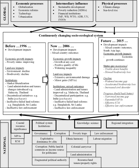
Figure 1. Global and national factors shaping the character of changing socio-ecological systems in the tsunami-affected Asian countries, past, present and future
The overall pattern has been intensification of land uses that existed during previous decades, and even then needed management (Ambio 1988). The Asian tsunami-affected countries, perhaps with the exception of Myanmar, chose economic growth at the cost of the environment in a world dominated by trade liberalization (Time International, 9 October 2006). Worldwide economic growth that existed before the 1990s accelerated as free trade expanded. Globalization today is driving most of the land uses on a scale that did not exist in the 1980s. Globalization can harm the environment for the following reasons (Harford 2006):
The Asian Development Bank (ADB) concludes (ADB 2005) that little progress has been made in harmonizing development and the environment since 2001 (Box 3).
|
Box 3. Asian Environmental Outlook — AEO (ADB 2005) Despite the considerable attention placed on environmental issues in recent years, environmental conditions throughout the region have continued to deteriorate. At about the same time that AEO 2001 was being prepared, the Millennium Declaration resulted in governments and organizations across the globe committing to achieving the eight Millennium Development Goals by 2015, with Goal 7 being to: “Ensure environmental sustainability.” Economic growth in most countries of Asia and the Pacific over the past 15 years has been truly impressive; it has resulted in a significant reduction in income-based poverty across much of the region. However expanded economic activity in and outside the region has placed tremendous strains on the environment; this has undermined some of the development gains achieved owing to the negative health impacts of urban air and water pollution and degradation of natural systems upon which most of the rural poor depends for its livelihood. |
Conflicts characterize the relations among economically disparate coastal land uses. Those backed by global finance are capable of influencing the highest level of government (Stiglitz 2002). Money is the ultimate determinant of power and influence (Todd 2004). The implication for the coastal poor is whether governments may or may not regulate access by the rich and powerful to the same resources that they demand. The dominant political elites in all the Asian tsunami-affected countries, whether or not backed by global capital, have an exploitative relationship with coastal residents engaged in traditional livelihoods. The future appears bleak for the poor until they acquire countervailing power by way of becoming organized (as in Kerala) in order to negotiate with governments (Kurien 2005). Land reforms in some countries, for example Bangladesh and India, have provided apparent benefits to coastal farmers during early stages. However, these benefits appear to have dissipated in the face of competition from capital-intensive and commercial land uses such as shrimp farming, tourism, industry and port development.
Indonesia illustrates how free market policies gone awry instead of competition among unsustainable land uses aggravate poverty. The economic prosperity of some Asian tsunami-affected countries such as Indonesia, Malaysia and Thailand was challenged by the economic downturn of the late 1990s. Malaysia and Thailand recovered relatively unscathed. However, the restructuring and reforms implemented by Indonesia as recommended by the International Monetary Fund resulted in serious economic consequences and social chaos (Stiglitz 2002). Poverty was aggravated to a level that existed in the 1980s.
Agricultural production is the mainstay of economic sustenance in most Asian tsunami-affected countries. Possession of land rights also typically ensures a baseline of shelter and food supply and allows people to turn latent assets into live capital through entrepreneurial activity. Once secure in their land rights, rural households invest to increase productivity. Moreover, the use of land as a primary investment vehicle allows households to accumulate and transfer wealth between generations. The ability to use land rights as collateral for credit helps create a stronger investment climate and land rights are thus, at the level of the economy, a precondition for the emergence and operation of financial markets (De Soto 2000; Stern 2005; World Bank 2003).
2.1 Land uses
2.1.1 Pollution
Inadequately regulated land use results in discharges and emissions that cause air and water pollution. The consequences of pollution for small-scale fisherfolk were recognized in the late 1980s (Ambio 1988). New Delhi, Calcutta, Kanpur and Jakarta rank among the ten most polluted cities in the world. Their discharges eventually reach the coast and impact on coastal resources. Asia’s coral reefs are already partially destroyed by climate change, destructive fishing and pollution. Air and water pollution impose severe stresses on health, mainly on the poor, particularly in South Asia, where many people lack safe drinking water and sanitation (Time October 9, 2006). Pollution in the Asian tsunami-affected countries is likely to become worse unless strict environmental safeguards are enforced (GPA 2005).
2.1.2 Small-scale artisanal fisheries
Marine fisheries and coastal aquaculture production in the Asian tsunami-affected countries expanded substantially during the past decade with the exception of Thailand where it declined. Coastal aquaculture in the Maldives is insignificant (Table 5). A feature of marine fisheries is competition and the juxtaposition of technologically modernized fishing fleets and traditional small-scale craft. The former frequently supported by government policy and by development financing, the latter relatively marginalized and dependent on informal financing.
A precise definition of small-scale artisanal fishery is difficult since the craft and methods are diverse and adapted to local geography and species complexity (Panayotou 1982; Kurien 2005). Moreover, fishing craft considered to be small scale in Malaysia and Thailand are regarded as large commercial craft in South Asia — small scale being more important for food security (FAO 2000; 2004).
Table 5. Production from marine fishery and aquaculture (crustaceans) in 1995 and 2002; the population of fisherfolk in 1994 (FAO 2004)
|
Country |
Marine fishery production (tonnes) |
Aquaculture production (tonnes) |
Estimated f’folk population |
Rate of population increase (% per year) |
||
|
1995 |
2002 |
1995 |
2002 |
|||
|
Bangladesh |
264 650 |
415 420 |
34 000 |
65 579 |
1 057 951 |
1.9 |
|
India |
2 656 862 |
2 957 157 |
70 000 |
145 000 |
3 837 387 |
1.8 |
|
Indonesia |
3 202 943 |
4 189 444 |
148 514 |
170 315 |
2 909 000 |
1.6 |
|
Maldives |
119 048 |
160 981 |
nil |
nil |
22 268 |
3.3 |
|
Malaysia |
1 108 436 |
1 272 105 |
7 481 |
26 428 |
100 000 |
2.4 |
|
Myanmar |
602 885 |
1 008 113 |
1 143 |
6 570 |
962 000 |
2.1 |
|
Sri Lanka |
214 171 |
270 130 |
3 329 |
4 642 |
120 000 |
1.4 |
|
Thailand |
2 844 409 |
2 715 716 |
234 744 |
193 584 |
65 000 |
1.5 |
The significance of small-scale artisanal fishery to national economies is high. The statistics provided by India indicate an associated population of about 14.4 million living mainly in about 3937 coastal villages. The vast majority of the fisherfolk engage in subsistence-level fishing, consuming a part of their daily catch and selling the remainder for consumption at the local level. It contributes about US$6 billion to national income, which is about 1 percent of the total GDP. This production elevated India to the position of fourth largest fish producer in the world with total production of about 6.3 million tonnes in 2003 and 2004. This production constitutes about 90 percent of domestic fish consumption. The situation in India is similar to that which prevailed prior to 1980 in the Asian region (Panayotou 1982). The general rate of population increase suggests that numbers also are likely to increase, although at different rates, during the coming decades (Table 5). The significance to the economy is shown in Table 6. Fisherfolk have customary use rights to the marine and terrestrial resources that they depend on (Salagrama 2005).
Table 6. The relative importance of trade in fishery products in 2002 (FAO 2004)
|
Country |
Fishery products (tonnes) |
Fishery products as % of agriculture exports |
Fishery products as % of total merchandise exports |
||
|
Exports |
Imports |
Balance |
|||
|
Bangladesh |
305 381 |
9 728 |
295 653 |
75.3 |
5.1 |
|
India |
1 411 721 |
36 490 |
1 375 231 |
20.4 |
2.9 |
|
Indonesia |
1 490 854 |
77 148 |
1 413 706 |
19.4 |
2.6 |
|
Maldives |
55 937 |
2 896 |
53 041 |
99.9 |
62.2 |
|
Malaysia |
377 584 |
387 049 |
9 515 |
Less than 1.0 |
Less than 1.0 |
|
Myanmar |
248 343 |
1 285 |
247 085 |
34.7 |
8.3 |
|
Sri Lanka |
83 736 |
71 205 |
12 531 |
7.9 |
1.8 |
|
Thailand |
3 676 427 |
1 042 103 |
2 643 324 |
31.0 |
5.5 |
The livelihoods of small-scale artisanal fisherfolk are now clashing with commercialized fisheries and other uses of coastal resources. Non-fishery activities are supported by government policies, and allocated investment and property rights. Where conflict resolution is attempted through litigation, small-scale artisanal fisherfolk are highly vulnerable in the face of statutory and common law based upon written legal procedure. These procedures are alien and incomprehensible to them, as in agriculture, because they are accustomed to customary rights (Wily 2006). Comprehensive literature exists on poverty in fishing communities (Macfadyen and Corcoran 2002). The clash of small-scale traditional enterprises and sometimes multinational business ventures is not confined to developing countries.
2.1.3 Aquaculture (shrimp)
Shrimp farming is not a uniform activity. Both small-scale operators and more powerful larger scale operators exist side by side. In Indonesia tambak (fish pond) aquaculture dates back many centuries. Commercial shrimp farming has achieved massive growth during recent decades (Table 5). The industry has been hailed as being capable of producing large volumes of food without impacting on marine stocks and increasing the availability of food for the hungry (FAO 2004). The sustainability of aquaculture as the “blue” counterpart of the agricultural green revolution is questionable (Wolowicz 2005). Governments and the international donor community have promoted shrimp farming as a means of accelerating development and alleviating poverty in developing countries. However, the expansion of export-oriented shrimp culture has met with strong opposition from some sectors of society, and serious political, socio-economic and environmental concerns have been raised (EJF 2003).
Shrimp farming has increased land values and led to conflict over land rights and access to natural resources. Resulting social problems include increased poverty, landlessness and food insecurity, displacement of communities, pollution of drinking water, poor working conditions and impacts on health and education. Large tracts of agricultural land have been inundated with saline water to create shrimp ponds. Shrimp farming physically invades farmland and saltwater intrusion can change soil composition and pollute water supplies. Shrimp aquaculture has had direct impacts on crop productivity and on the health and livelihoods of rural farming communities (EJF 2003).
In Indonesia, in 1998, the area under shrimp cultivation approximated 305 000 hectares. The impetus for expansion was provided mainly by ADB and the World Bank. The Government of Indonesia asserts that about 800 000 hectares, about one-third of the remaining mangroves, are available for shrimp ponds (Down To Earth No. 58, August 2003). These conflicts may persist into the future because the contribution from coastal aquaculture to national economies is becoming increasingly significant while marine fishery production stabilizes (FAO 2004). The Maldives is an exception because it does not have the space for shrimp farming (FAO 2004).
The impact of shrimp farming on rice cultivation may seriously undermine food security in Bangladesh. During the late 1990s, rice production in the coastal zone decreased by 26 percent, while the cultivated area decreased by only 1 percent (Islam 2004). Recent research (Alamgir Choudhury, personal communication) suggests that reversion to rice cultivation is occurring in some coastal polders in Bangladesh where adequate irrigation water is available from shallow tubewells.
2.1.4 Agriculture and forestry
In Asian tsunami-affected countries, agriculture and forestry are in the same land-use equation. The destruction of rain forests which generated a loss of 33 percent in Asia, particularly in Malaysia and Indonesia, between 1960 and 1990 continues at even greater rate today. The direct causes are agriculture, cattle raising, damming and megaprojects, logging, plantations, shrimp farming, slash-and-burn activities and mining (BBC 2005). The World Rainforest Movement http://www.wrm.org.uy/forests/future.html) identifies several underlying causes including:
Tropical deforestation is most serious in Indonesia and Malaysia. It is likely that China, like Japan, will export deforestation activities to Indonesia and Malaysia while conserving its own forests (Diamond 2005). Since 1996, Indonesian forest loss has accelerated to 2 million hectares per year. Forests have been almost entirely cleared in Sulawesi while they are predicted to disappear in Sumatra and Kalimantan in the coming decade if the existing trend persists (Global Forest Watch http://www.globalforestwatch.org/english/indonesia/forests.htm). Diamond (2005) foresees that rape-and-run logging will be exacerbated in these countries by corruption.
Rates of deforestation occurring in Malaysia, the world’s largest exporter of tropical timber, resulted in the loss of 2.7 million hectares during the 1990s. This amounts to about 13 percent of the country’s forest area. A further “legal” deforestation of 3.9 million hectares is reportedly underway. This is being done under a certification scheme under the Malaysian Timber Certification Council (MTCC). However, concerned observers claim the MTCC is only a pretext for legality because logging is done without meaningful consultation with local people whose livelihoods are linked to forests (Barry 2001; 2004).
Forest management in the Asian member countries of the International Tropical Timber Organization (ITTO) reportedly has improved (ITTO 2006). In all Asian tsunami-affected countries where the natural forests are owned by the state, more extensive support is required for community-based agroforestry, with appropriate tenure rights, to reduce the pressure on primary forests for subsistence products (WCFSD 1999; Ostrom et al. 1999). Customary tenure rights are claimed by indigenous populations who live in the forests of India, Indonesia, Malaysia and Myanmar. Privately owned forests are rare although rubber plantations are a major source of wood for industries in Malaysia and Thailand.
Forest management in India has aroused much controversy. Government measures such as the Forest Bill proposed in the mid-1990s was regarded as a retrograde step which ignored the tenurial rights of forest communities. One of the most controversial elements is that an official may annul community and individual rights in forests if it is deemed that these rights exceed the “carrying capacity” of the area. The recent report of the Forest Commission, which was established in 2002, is regarded as a repetition of earlier recommendations whereby government acquires power to over-ride community and environmental requirements.
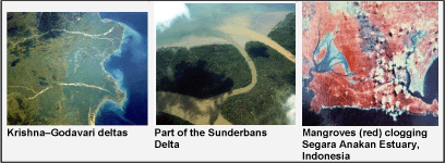
The forests in the coastal zones include mangroves and peat swamps. Many coastal communities have traditionally harvested forest products in mangrove forests in Bangladesh, India, Indonesia, Malaysia, Myanmar and Thailand. Loss of mangroves has been compensated in some countries — 142 000 hectares of mangroves have been planted in Bangladesh in shallower sections of the delta. In Indonesia and Malaysia, mangrove cultivation has been incorporated into coastal aquaculture (Primavera 2000). Deforestation upstream has consequences for sedimentation downstream to the extent that some coastal ecosystems — for example Segara Anakan Cilcap, Indonesia — have been smothered by excessive loads which are then stabilized by mangroves (White et al. 1989). In Indonesia the cost of environmental damage to coral reefs from logging-induced sedimentation greatly exceeds benefits from logging (Cesar 2000).
The WWF provides regular updates on serious problems in Southeast Asia with regard to forestry management, biodiversity, agriculture and poverty — for example in Indonesia (http://www.livingplanet.com/about_wwf/where_we_work/asia_pacific/where/indonesia/index.cfm).
2.1.5 Ports and navigation
Ports and navigation facilities have expanded during the past decade. The changes have been driven by the emergence of China as a global economic power. China’s continued growth is crucially linked to energy supplies, primarily oil and gas. The Malacca Straits, which in places narrows to about half a nautical mile and is only 25 metres deep, is today the busiest sea lane in the world; this has serious implications for coastal communities. Some 50 000 vessels, carrying roughly a quarter of the world’s maritime trade pass through it annually. So do about half of all seaborne oil shipments on which the economies of Japan, China, and Republic of Korea depend. (Economist 2004).
Port expansion at diverse coastal locations in Indonesia, Malaysia and Thailand may be anticipated. India has already begun construction of the Sethusamudra Ship Channel across the Palk Straits separating Sri Lanka from the subcontinent (Tuticorin Port Trust 2005). Oil shipments undoubtedly will pass through it. A spill could be disastrous to the livelihoods of the associated coastal communities of India and Sri Lanka. National interest supersedes low-income livelihood.
Juxtaposing the expansion of regional trade and shipping, port development becomes inevitable. Recent events in Andhra Pradesh, India demonstrate the conflicts that emerge. Fisherfolk from nearby villages have joined Visakhpatnam port workers to agitate against Gangavaram Port construction. The expensive port project, on the Bay of Bengal, near Vishakhapatnam, will deprive at least 3 600 families from Gangavaram fishing village alone. But the district administration has identified only 1 550 families as beneficiaries (Deccan Herald, April 10, 2006: http://www.deccanherald.com/deccanherald/Apr102006/national182442200649.asp).
2.1.6 Industry: steel production and ship breaking
Worldwide demand for steel is increasing. Chinese and Indian steel producers have become influential players in the world market. India’s recent acquisition of major European production facilities suggests expansion in future. One source of raw material is steel scrap including discarded ships. Bangladesh and India are leaders in the ship-breaking industry which supplies scrap iron as raw material. In India annual consumption of scrap is 8 million tonnes while supply is 6 million tonnes (OECD 2006). It is likely that the production of scrap iron from various sources, including ship breaking, will increase in the future. Ship breaking is a coastal activity.
Recycling ship construction materials is a highly desirable activity that can be environmentally beneficial. However the manner in which it is being carried out has no social and environmental safeguards. It has acquired prominence as an environmentally damaging activity in some coastal stretches of Bangladesh and India. The serious environmental and social consequences of unregulated ship breaking are recognized as a violation of the Basel Convention. Ship breaking provides jobs and income to the coastal poor who are increasingly being driven out of traditional occupations. However the benefits are dubious when taken in the overall context of occupational health risks and environmental pollution (Greenpeace: http://www.greenpeace.org/india/campaigns/toxics-free-future/ship-breaking).
2.1.7 Tourism and recreation
Tourism is the world’s primary export earner, ahead of automotive products, chemicals, petroleum and food; it was valued in the region of US$500 billion in 2000 (UNEP: http://padh.gpa.unep.org/page.cfm?theme=1). In ASEAN countries, regional tourism has grown sharply because of relaxed travel and currency regulations. Coastal tourism has been a leading contributor of foreign exchange to the national economies of all the countries, perhaps with the exception of Myanmar. In the Maldives the total annual tourist arrivals from the west exceed the national population. Room capacities in the popular coastal resort areas increased significantly during the past decade. Both India and Bangladesh are investing in coastal tourism because international tourism in South Asia is predicted to double during the next decade (UNWTO: http://www.unwto.org/).
The single most important factor contributing to tourism growth will be the pace and quality of infrastructure which combines air travel and resort development. The high density of coastal populations limits the availability of land for infrastructure development. Consequently, government incentives play a significant role in attracting investors. The post-tsunami government policies reveal a greater commitment to the development of coastal tourism than to ensuring the well-being of affected coastal communities (Tourism Concern 2005; UNHCR reports). Externalities from tourism development are a growing and serious concern because of competition for land with small-scale artisanal fisherfolk in India and in Sri Lanka. In the Maldives, measures are now being implemented to minimize adverse impacts on coral reef health.
The tourism industry creates more than 10 percent of global economic output and one in nine jobs with anticipated annual revenues of US$1 550 billion by 2010. The economic benefits of tourism development to developing countries are limited. Estimates suggest that 60 to 75 percent of income leaks away from developing countries because of foreign ownership of the industry, imported resources, foreign tour operators, airlines and other reasons. The poorer a developing country is, the higher the probability that the gross expenditures for tourism are greater than the earnings from it (Hemmati and Koehler 2000).
2.1.8 Urbanization and settlements
Settlement growth in ASEAN countries has been driven by a strategy of cooperation and complementarity, which has combined planning with ongoing developments in industry and regional economic cooperation — so-called “growth triangles” (Hiroshi Kakazu et al. 1998). The growth triangle implemented at the southern end of the Malacca Straits is an example. This includes Malaysia (Johore), Indonesia (Batam and Bintan Islands) and Singapore. The population of Batam, which was about 6 000 in the 1970s, increased to 198 000 in 1995. The projected population in 2006 was 700 000. These developments may create more congestion in the Malacca Straits and increase the pollution risk. Pollution stemming from municipal sewage was recognized as a growing problem in the Southeast Asian region in 1988 (Ambio 1988).
In South Asia urbanization has been mainly a consequence of increasing poverty in rural areas, driving urban migration. The consequences when urban migration occurs without planning for the key labour population is demonstrated by Dharavi on the outskirts of Mumbai, India; this is the largest slum in the world with a population of about one million. This slum grew progressively from a fishing village and a tanning centre (Wikipedia http://en.wikipedia.org/wiki/Dharavi).
Settlement expansion in coastal areas in Malaysia is threatening natural ecosystems. The Merbok mangroves presently cover an area of about 2 800 hectares. They were previously surrounded by mainly rice, rubber and oil palm cultivation. A rapidly growing town, Sungai Petani, lies contiguous with the Merbok estuary. There were some 8 000 hectares of mangroves 50 years ago. Initially, about 2 800 hectares were converted to rice fields. Another 2 400 hectares were lost to shrimp farming in the 1970s. Now significant areas are being converted into housing estates. This trend suggests there will be few or no mangroves left in Merbok by 2020 (Haywood et al. 2001).
Land created naturally by river sedimentation in Bangladesh is an opportunity for the expanding poor coastal population to earn a living from agriculture. A population density of 813 persons/square kilometre, likely to increase by another 50 percent by 2020, makes land a scarce commodity. Forced land accretion is likely to supplement natural sedimentation unless urban migration relieves pressure in rural coastal areas. Natural land development in Bangladesh has benefits for the coastal poor when such land is equitably distributed to the landless. However, this may not be the reality because such land, which by law belongs to the state, is commandeered by politically powerful individuals (Islam 2004).
2.1.9 Marine Protected Areas (MPAs)
Many MPAs have been established in Asian tsunami-affected countries (MPA Global: http://www.mpaglobal.org/index.php?action=aboutus). They are a mechanism for safeguarding habitats critical for biodiversity, marine productivity and small-scale fishing income. The recent findings on the status of the world’s marine fishery stocks suggest that MPAs are an important management intervention for arresting the collapse of overfished fishery stocks (Worm et al. 2006). The near future is likely to witness a major increase in the area under MPAs, with countries like Indonesia setting ambitious targets (Salm et al. 2000). Increasing the area under MPAs is likely to have major repercussions for small-scale fishing communities. They could be positive if traditional rights of access and use of resources are strengthened. They could be negative if implemented in non-participatory and exclusionary ways.
2.1.10 Summary — the challenge for ICM
Meaningful contribution from ICM to the problem of land-use conflicts could be substantial. ICM may facilitate integrated land uses which provide win-win solutions to both traditional coastal resource users and to commercial enterprises. How ICM confronts predation by powerful commercial interests — the extraction of benefits from the capture of assets that rightfully belong to coastal communities — will be the major challenge. Traditional coastal land uses on which millions of households depend for their livelihoods and national and commercial interests may be harmonized within carefully designed land-use zoning systems.
2.2 Land tenure
Land and resource tenure in the context of poverty, environment and ICM is a complex subject. The brief overview of competing land uses in the previous section reveals that the only effective mechanism that can safeguard the land-use interests of traditional coastal users is the adequacy of political power acquired through organized activism (Etzioni 1968). The goal of activism is to acquire legal tenure rights over land and coastal space adequate for livelihoods. Armed with such rights, coastal communities may be empowered to negotiate terms and rules for new development in a manner that enhances their own well-being (Stern 2005).
As economic growth linked to market liberalization continues in Asian tsunami-affected countries, property values and investment opportunity mainly drive decisions on land use with little regard to environmental quality, poverty and equity. If genuine commitment is made to reducing rural poverty, the landless and resource-poor farmers as well as small-scale fisherfolk need to be given rights over land and the common property resources they depend on. To decisively improve this relationship, “land/tenure reform” persists as the central issue, most particularly in India, Indonesia, Bangladesh and Myanmar (Prosterman and Hanstad 2000).
“Land reform” as a term in land administration has evolved to become more complex during the past decade. The concept of market-led agrarian reform (MLAR), put forward by the World Bank, is a voluntary approach to land reform. MLAR is a policy model founded on the willing seller–willing buyer principle whereby landlords are paid 100 percent spot-cash for 100 percent market value of their land and where peasant beneficiaries shoulder 100 percent of the land cost. On most occasions, and formally, the World Bank declares MLAR to be a complementary policy to other approaches to land reform, specifically the conventional state-led mechanisms. This is contested by Borras (2005). How MLAR may benefit rural farmers who do not have investment capital is enigmatic.
Land and resource tenure in agriculture, forestry and fisheries are recognized as a colonial legacy which continues to be a tenacious root cause of rural poverty. Asian tsunami-affected countries which were under colonial rule have undertaken various forms of redistributive land reform mainly with regard to agriculture and landless peasants. Persistent severe poverty in these countries, with the exception of Malaysia, testifies to their only partial effectiveness. Land administration in these countries ranges from total ownership of agricultural land by the state, as in the Maldives, to minor ownership by it, as in Thailand. “Tenure insecurity is a socio-political condition engineered intentionally or otherwise by policies — and is remediable by policies” (Wily 2006). Land reform at the policy level then must aim at providing tenure security to the landless and poor.
2.2.1 Coastal resource tenure
Coastal resource tenure poses a greater challenge. Forms of community coastal tenure already exist in the Maldives, the Surin Islands, Thailand (UNESCO 2001) and in Sri Lanka. The concept of “coast” in the Maldives includes the total land area of each island and its surrounding lagoon, extending over the reef flat to the outer edge of its reef. While some individual homes and agriculture plots are delineated in this “coastal area”, the rest of the land area — the beach, lagoon and reef — are community wealth and used by all (Hameed and Ali 2001).
Land and resource tenure and their implications have been extensively analysed in connection with agriculture in the context of land reform policy (e.g. World Bank 2006). Less information exists on the relationship between sea and coastal resource tenure. Generally land reform refers to the terrestrial component. However, complex problems of ownership exist in relation to coastal waters and contiguous land. How may coastal communities “own” migratory fish stocks? Although stocks migrate there are periods when they reside at sites with appropriate sea floor ecology, for example sea-grass beds.
In the vast number of small-scale fisheries in Asia the choice of livelihood is extremely limited. Therefore it is important to move away from an open access regime and redefine rights of access for a new unit of people — a group that has a linkage to the sea because of its willingness to work there (Kurien 2002). This has the added advantage that community ownership instead of individual rights enables safeguards against predatory capture of coastal land by powerful investors. The associated problems are not insurmountable. A combination of vision and courage to move beyond rational behaviour is a prerogative. Community ownership of common property resources does not necessarily lead to the “tragedy of the commons” (Ostrom et al. 1999). With appropriate training and awareness, communities will evolve rules for sharing of common property resources over which they acquire rights (see section 3.3).
2.2.2 Rural agricultural poverty
Poverty will decrease in Asian tsunami-affected countries only to the extent that it does so in the three most populous countries India, Indonesia and Bangladesh. The share of the population in millions living on less than US$1.00/day in these three countries exceeds the combined populations of Malaysia, the Maldives, Myanmar, Sri Lanka and Thailand — India: 360; Bangladesh: 50 and Indonesia: 15 million (World Bank 2006).
The poor in rural India are mostly landless agricultural labourers, marginal and small farmers. Empirical data suggest that despite agrarian land reform, marginalization is increasing. The trends reveal that the land-based poor are becoming poorer. Among the arguments put forth, the pro-poor impact of legalizing tenancy has gained momentum. It is felt that the majority of smaller marginal farmers will benefit. Presently there is no protection for the tenant or for the landlord. Further, at present the tenant cannot obtain required capital from banks and financial institutions (Deshpande 2002; De Soto 2000).
The land administration system in Indonesia has changed since colonial rule. Under the Basic Agrarian Law (BAL) of 1960, land rights can be transferred to the people by the state. The complexity of land laws related to land issues in Indonesia results in numerous conflicts, particularly in securing land rights for traditional and indigenous communities. Legal instruments, although they have improved, do not automatically ensure equity. The agricultural census data in 1993 show that 84 percent of rural households (owning 0.5 hectare/household) own and use 13 percent of agricultural land. Rich households (>1 hectare per household) own and control 70 percent of total agricultural land. From 1983 to 1993, the percentage of farmers not owning land increased from 40.8 percent in 1983 to 48.5 percent in 1993. This trend has continued in the succeeding decade (Royat 2002).
Land conflicts are increasing both in rural and urban areas. Due to rapid urbanization, large swathes have been acquired for settlement, real-estate, golf courses and so forth through the National Land Agency (BPN) to encourage investors. Encroachment occurs at the rate of about 30000 ha each year, mostly on fertile land for non-agricultural use. Comprehensive review of existing reforms and improvement in enforcement of regulatory laws is required to support the national poverty reduction strategy (Royat 2002). Massive deforestation (both legal and illegal logging) and expansion of agriculture into state land appears to mock Indonesian land laws that profess to reduce poverty by making cultivable land available to the landless (WWF: http://www.panda.org/about_wwf/where_we_work/asia_pacific/where/indonesia/news/index.cfm?uNewsID=80262 ).
Through polderization, Bangladesh has demonstrated that investment in agricultural development in its coastal area has contributed to poverty reduction (section 3.1). Cross-dams have been constructed in some coastal areas to force accretion and to reclaim eroding land. The consequences of coastal land formation do not necessarily result in benefits for the poor because of land grabbing by those who are politically more powerful (Islam 2004).
Sri Lankan land administration differs from other Asian tsunami-affected countries in that the state still holds within its jurisdiction about 80 percent of the land, despite a land reform law introduced in 1972. The Land Reform Law (1972) had a major impact on land administration in Sri Lanka. As the Land Commission subsequently clarified in 1987, the experiment was an unqualified failure. Most rural poor continue to have small landholdings which are inadequate to support subsistence requirements. With each succeeding generation, landholdings become smaller. To reverse the relentless fragmentation of agricultural land into ever smaller plots, one option is to promote urban migration (Ratnayake 2002). Other policies associated with Sri Lanka’s land administration have led to diverse grievances with regard to land sharing among ethnic communities. These policies are partially responsible for the ethnic conflict which has existed in Sri Lanka for almost three decades (Hasbullah et al. 2005). Now there is debate about the feasibility of providing rural farmers with market-oriented tenure rights based on a World Bank recommendation (Dissanayake 2006).
2.2.3 Land reform and empowerment
Land reform is about redistributing landownership from large private landowners to small peasant farmers and landless agricultural workers and implies a redistribution of wealth (Borras 2005). For true redistribution, land reform must change ownership of or control over land resources from the landed to the landless and land-poor classes, or from rich landlords to poor peasants. Here “ownership” or “control over land resources” means effective control over the nature, pace, extent and direction of surplus production and extraction, and the disposition of such farm surplus. Such a purposive change or reform is inherently relational: It must result in a net increase in poor peasants’ power to control land resources with a corresponding decrease in the share of power of those who formerly had such power over the same land resources and production processes. Land redistribution is essentially power redistribution (Borras 2005).
Redistributive land reform is also linked to the principle that land is not a simple economic factor of production. Rather, land has a multidimensional function and character (that is, with political, economic, social and cultural dimensions). Redistributive land reform, according to the aforesaid description, fits into the livelihood approach incorporated into addressing coastal poverty within the framework of ICM (see section 1.3). It also fits into the outlook that seeks to increase the resilience of coastal communities (Adger et al. 2005).
2.2.4 Gender
Tens of millions of Asia’s rural poor are landless, who along with indigenous people and persons with disabilities, in particular the women among these groups, comprise the poorest of the poor. (Polman 2004). The rights of women to property inheritance are a serious problem in post-tsunami reconstruction in Sri Lanka.
2.2.5 Land administration and land titling
Williamson (2000) discussed best practices in land administration and presents conclusions that are important for policy-making with regard to tenure reforms. He clarifies that the task of establishing a land administration system similar to those in industrialized countries would take more than a century. However, reforms are essential. Therefore, it may be approached strategically. There are two components required in a strategy:
The aforementioned professional view suggests the need for engaging in smaller sub-projects that contribute to the overall vision. In this context the recently completed Land Titling Project in Thailand provides an instructive case study (section 3.5).
The case histories are indicative and are meant to reveal the main combinations of global and national factors that have determined existing outcomes in relation to the frameworks given in Figure 1 and Table 4. They were identified and selected on the basis of several criteria:
3.1 Investment in coastal agriculture: polderization in coastal Bangladesh
This case history is based partially upon the author’s first hand experience of working as a member of the team of the Integrated Planning for Sustainable Water Management (IPSWAM) project of the Bangladesh Water Development Board (BWDB), and Islam (2004). Additional reasons for its selection were:
3.1.1 Setting
The coastal area of Bangladesh includes a vast area of about 47 201 square kilometres consisting of 23 935 square kilometres of exposed coast and 23 266 of “interior” coast. The exposed coast consists of administrative land units (upazillas) facing the sea. The interior coast is made up of upazillas situated in the tidal rivers so that they are partially sheltered (Figure 2). This area houses about 30 million people. The coast of Bangladesh has multiple vulnerabilities. Seventy major cyclones have hit the coastal belt during the past 200 years. In 1991 a major cyclone affected 13.7 million people causing 138 882 deaths. During a similar cyclone in 1997, due to better disaster preparedness and effective coordination by the government, only 134 deaths occurred (BCAS 2001). Destructive floods are regular.
Historically, accreted land (chars) in the lower reaches of the Ganges–Brahmaputra–Meghna river system was colonized by people who were highly adapted to living in the dynamic delta. They cultivated rice in the rich alluvial soil. These settlements were exposed to salinity intrusion, frequent hurricanes, cyclones and seasonal floods. Any savings from one good year were rapidly exhausted in rebuilding after a storm or flood. Life was harsh and short. Life on present day chars is vividly reminiscent of the conditions that existed in the past (Sarkar et al. 2003).
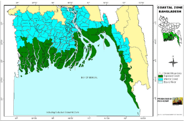
Figure 2. The coastal zone of Bangladesh showing the exposed and interior coasts (Source: PDO-CZMP)
3.1.2 Polderization
Starting in the 1960s the Government of Bangladesh (GoB) invested in the transformation of the physical geography of settlements in the coastal area to enable increased output from rain-fed rice cultivation. The alteration of physical geography resulted in the formation of a polder “… an area surrounded by watersheds where the water level is artificially controlled” (De Ven 1993). The BWDB implemented the process, with international support, which included the construction of 5 107 kilometres of embankments, 1 347 drainage regulators and 6 053 kilometres of drainage channels. The process still continues.
In addition to the planned increase in paddy output, the unplanned outcomes were:
Polderization entrained consequences which are significant in the face of emerging uncertainties associated with climate change and sea-level rise. Today the residents of these polders are in a position to plan adaptation measures to address the impacts of sea-level rise in a manner that may have been otherwise impossible. However, there have been environmental trade-offs particularly with impacts on the hydromorphology of the tidal rivers and socio-economic losses caused by diminished fishery within the polders. The changes have been aggravated by alteration of transboundary flows of the Ganges passing from India to Bangladesh (Samarakoon 2004).
The residents in the polders, on inception, invested time and effort in diverse forms of tree planting on embankments, roadsides and home gardens when the opportunity cost of labour was conducive. Benefit-sharing schemes were supported by the Forest Department. Agroforestry has visibly enhanced biodiversity. Commercial spin-offs include industrial timber production supported by locally harvested trees, medicines, food and fibre.
Progressive improvement of road infrastructure in later decades has linked many coastal polders to highways. Thus isolated polders are now integrated with urban markets. Overall economic growth is expressed in some polders as a property boom. Tenant farmers and agricultural workers previously obtained seasonal employment on terms favourable to the landowners. Seasonal employment opportunities in accessible urban centres have now tilted the bargaining position in favour of the tenant farmers and agricultural labourers. The poverty of tenant farmers and agricultural labourers has declined (Hossain et al. 2002).
Security to life and property entrained by polderization and improvement in the quality of life associated with ancillary development policies for health, literacy and poverty reduction have changed the attitudes of rural communities. They are investing more in children’s education and health in view of their own enhanced life expectancy. Parents now live long enough to witness the benefits. Farmers are learning and investing in agricultural technology because flood risk has declined. Investment in agriculture has been complemented by many socio-economic spin-offs (Schultz 1979).
The poorer segment of polder residents is facing new challenges. Globalization has resulted in highly fluctuating prices for shrimp and other produce. Landless agricultural labourers who earned supplementary income from shrimp seed collection have suffered losses from the combined impact of national fishery policy and falling shrimp prices. In the coming years they will have to face problems of more frequent coastal storms, heavier rainfall and floods associated with climate change and sea-level rise. As land values rise, property development could begin to compete with agricultural land in the polders nearest urban centres.
Values are changing among both parents and children as remittances from overseas boost the prestige of recipient families. Increasing numbers of farm labourers, small-scale fisherfolk and the poor in general are seeking urban employment to pay the initial deposit, at great risk, for acquiring jobs for their sons in the Gulf States and in Malaysia. Daughters, now literate, because of free compulsory education, are seeking urban employment with regular monthly salaries.
3.2 Kerala small-scale fishery, political power and sustainability
This case history is based upon published literature. The thematic material was obtained from Kurien (2002; 2004; 2005). The purpose of the case history is to illustrate:
3.2.1 Setting
Kerala State is a narrow strip of land at the southwestern tip of India. The state has a population of 30 million and a 600-kilometre coastline. It is densely populated (average of 750 persons/square kilometre, but generally exceeding 1 000 persons/kilometre in fishing villages). The low-lying coastal plains are dominated by backwaters, which provide critical nursery areas for penaeid shrimps — the chief source of foreign exchange.
3.2.2 Small-scale fisherfolk and the Kerala Model
Kerala State became prominent in 1957 as the world’s first democratically elected communist government. It established a very high quality of life despite low per capita income (the Kerala Model). Kerala’s human development achievements of high literacy, low infant mortality, high life expectancy and a gender ratio favouring women, match those of many developed countries. The two exceptions were:
Fishing communities in Kerala have tribal origins. They were later incorporated into the Hindu caste hierarchy and placed at the bottom. Around the fifteenth century many in the coastal region converted to Christianity. Caste and religion were the defining identities of fishing communities in Kerala.
3.2.3 Evolution of Kerala’s small-scale fishery and technology
The world’s first community development project for fisheries — the UN Indo–Norwegian Project for Fisheries Community Development (INP) was initiated in Kerala in 1953. It aimed to upgrade the fishery sector and improve the standard of living of the fishing community. But it became the unintended catalyst for launching all of Kerala’s fisheries into a Western-oriented export drive. The fish economy was anchored to the new international market and sowed the seeds of lopsided development — the existing beach-based artisanal fishery was ignored for being traditional and unscientific; a new modern superstructure based on harbour-based mechanized trawlers, with a single species orientation (shrimp) was actively promoted. When the INP started there were around 38 000 active marine fisherfolk.
The market was not free and open. Financiers who had advanced loans to fisherfolk laid priority claim to the fish and fixed prices. Landlords who permitted fisherfolk to stay on their land adjacent to the sea, took control of the right to sell the fish. The presence of a change agent who analysed the situation, encouraged and enabled market transformation. Through collective action, the fisherfolk established control over prices paid for the fish. This led to the establishment of the Marianad Cooperative, later singled out in Kerala’s official annual Economic review as the model for the state to free fisherfolk from the clutches of intermediaries.
As self-awareness developed the Kerala fisherfolk acquired a correct perspective with more accurate statistical information. Soon, a network of cooperatives formed. The economic viability of the network increased as the fisherfolk gained control of the species which were exported — initially shrimp, and later cuttlefish. From the enhanced income, the cooperative set aside a small savings fund to generate a cycle: Credit–production–marketing–savings, which expanded rapidly with growing fish sales. By 1980, the network of cooperatives expanded — it was ambitiously named the South Indian Federation of Fishermen Societies (SIFFS) — to become an apex body of small-scale fisherfolk cooperatives.
Government policy from 1960 to 1980 supported the modern, mechanized, trawler-fishing sector which emerged as an offshoot of the INP. Official thinking considered that all players in artisanal, small-scale fishery would either gradually use mechanized craft or just wither away. This did not occur. After two decades, as much as 80 percent of the marine fish harvest came from the artisanal, small-scale sector.
Challenged by the growing political power of the small-scale fisherfolk, the state legislature established Matsyafed — a formal institution to provide technical support exclusively to the small-scale fisherfolk. This bureaucracy is regarded as being insensitive to them (Ayyappan 1998). It was followed by a heavy flow of subsidized inputs, outboard motors, new boats and gear. By 2004, the number of active marine fisherfolk had risen to 190 000 spread over 220 villages along the coastline. Total marine fishery production stagnated at about 500 000 tonnes/year. Household incomes decreased as catches dropped and inflation pushed the cost of essentials higher.
3.2.4 Science and policy
Testable scientific information on the relationship between the coastal fishery and impact of technology was lacking although scientists offered diverse opinions, mostly favourable to government policy and the trawler fishery. At this juncture, FAO’s Bay of Bengal Programme (BOBP) conducted a pioneering study of fishing costs and earnings across Kerala which revealed that:
Policy-makers juggled with facts and ensured that they favoured the financially powerful trawler lobby and adopted strategies to blunt the militancy of the small-scale fisherfolk.
3.2.5 Fisherfolk struggles — emergence of group political power
Since 1980, artisanal fisherfolk had been agitating against the increasing encroachment of mechanized trawlers into their traditional fishing realm. They demanded:
A notable feature of sector activism was the gradual negation of old identities of caste and religion. A cohesive “occupational class identity” and a focus on the specific nature of fishery problems slowly became the underlying traits of the new movement. The women in the village joined the movement and became empowered (cf Mararikulam Experiment).
| Political power is a feature that belongs with groups. It is the ability of a group to resist imposed change and to mobilize resources for collectively favourable change (Etzioni 1968) |
Cutting across caste and religion, fisherfolk joined with independent trade unions to take up the cause of artisanal fishery. The elected political leadership realized that remaining unresponsive to the massive vote bank of artisanal fishing communities would be suicidal. A significant policy response of the state to the movement was the Kerala Marine Fisheries Regulation Act in 1980. The legislation zoned the sea within the state’s jurisdiction with an area reserved exclusively for artisanal fishing units. State patronage of trawling stopped.
3.2.6 Challenge to small-scale political power
Introduction of technology was used by political parties to co-opt the fisherfolk. It took a toll on the militancy of the independent fishery movement. The political parties hastily set up their own fisherfolk trade unions. It was easier for politicians to distribute fishing equipment and get votes. They used caste affiliations to identify beneficiaries. Politicians distributed thousands of outboard motors to a widely dispersed and poor fishing population. Each new fishing unit cost about 10 to 20 times the capital cost of the artisanal craft–gear combinations monitored in 1980.
The decision by the state to co-opt small-scale fisherfolk was the starting point of the massive investment spree in the artisanal fishery sector of Kerala. The introduction of outboard engines and new fishing gear for the artisanal fishing sector was hastened by two external factors, liberalization of the economy, which permitted easy import of Japanese engines, and the availability of large financial incentives from the state in the form of subsidies.
Eight years and two expert commissions later the first monsoon trawl ban was imposed in 1988. Armed with a recommendation, the government hastily implemented a total monsoon trawl ban for a month and a half. The future of the ban as a fishery management measure is in doubt. Given the political sensitivity of the issue, it is likely to stay to placate the majority of the fisherfolk. However, enforcement would be lax — a strategic approach to please both parties.
3.2.7 Open access and unsustainability
The need for a fishery policy to deal with inevitable overfishing and resource degradation under an open access regime led to the formulation of an “aquarian reform” package. Its highlights were:
After a period of low enthusiasm, in 2004 a draft appeared on the state’s official Web site.
3.2.8 Multiple-use conflicts and property rights
The burgeoning population pressure present in the coastal areas and the rapid urbanization and industrialization of the landward part of the coastal tract, point to new opportunities, conflicts and threats. The aspect that will warrant careful investigation and research in the coming decades relates to the globalization-spurred claims on the coastal zone and the consequent conflicts between users with historical (de facto) rights and those adopting new strategies to make de jure claims. The challenge is to develop new forms of community-based property rights; can they be articulated, codified and implemented?
3.2.9 Coastal Zone Management Regulations and ICM
The most significant specialized legislation in India for activities along the coast is the Coastal Regulation Zone (CRZ) Notification of 1991. However, this is observed mainly in the breach (Sathyamoorthy 2006). Conflicts between fisherfolk and those advocating the CRZ have emerged. Tourism investors appear to be in a more favoured position compared with the fisherfolk. The Kerala small-scale fisherfolk disagreed with the recommendations of the recent Swaminathan Committee (letter dated 10 September 2006 to the Minister of Agriculture www.keralafishworkers.org). Some aver that the most prominent violator of the CRZ is the Government of India itself (Mascarenha 1999). Attempts are also being made to implement ICM in Mararikulam area, Kerala within the framework of the Mararikulam Experiment (Chattopadhyay 2002; Franke 2002).
3.3 Ecosystem-based ICM: Muthurajawela Marsh–Negombo Lagoon Coastal Wetland, Sri Lanka
This case history is based upon the author’s first hand experience in its planning and implementation (Samarakoon and Van Zon 1991; GCEC/Euroconsult 1991; CEA/Euroconsult 1994; CEA/ARCADIS–Euroconsult 2006). It was developed to illustrate selected factors:
3.3.1 Setting
Sri Lanka has an area of 65 000 square kilometres and a coastline of 1 600 kilometres; it has many estuaries and lagoons that are important for rural livelihoods as well as for biodiversity. The Coast Conservation Department (CCD), established in 1981, included the Negombo Lagoon system for special area management (SAM/ICM) in the Coastal Zone Management Plan (CCD 1997). In 1989, while the CZMP process was ongoing, the executive president ordered preparation of a land-use plan based upon an ecological survey of the Muthurajawela Marsh and Negombo Lagoon system. This was a response to representations from technical departments and the public against a plan to fill the marsh component with sea sand for urban and industrial development. For the first time in Sri Lanka, an integrated coastal land-use plan was envisaged.
The Muthurajawela Marsh–Negombo Lagoon coastal wetland system (MM–NL system) on the west coast of Sri Lanka, encompasses approximately 6 000 hectares; it is composed of a tidally influenced marsh joined with an estuarine lagoon; it supports the livelihoods of approximately 18 000 people. It is situated in a watershed covering about 750 000 hectares in Gampaha District. This is the most industrialized district in Sri Lanka while the contiguous Colombo District with the capital city, Colombo, is the administrative and commercial centre of the country. Population concentrations exist along the margin of the MM–NL system. It is significant for drainage and flood protection. The lagoon is connected to the sea by its mouth at its northern end, a densely populated segment, also the site for one of the country’s major sea fishing anchorages.
The MM–NL system is enmeshed in the direct and indirect impacts of diverse land uses. Approximately 3 000 households depend upon the Negombo Lagoon for their livelihoods. The villages of the traditional lagoon fisherfolk are semi-rural. The cultural identity of the predominantly Roman Catholic population is linked to the lagoon by various church rituals. The beach to the north of the lagoon mouth was the first tourism resort, which was developed in the 1970s. The rapid escalation of property values in Colombo District is driving land developers northward, mainly into the Muthurajawela Marsh. Urbanization in Negombo Town situated at the northern margin, the Katunayake Free Trade Zone on the eastern margin and the smaller townships along the lagoon border are combining to progressively expand into the waterbody. The poor, because of unbearable land costs, illegally encroach onto both the marsh and the lagoon.
3.3.2 Planning: strategic land-use plan for the MM–NL
The vision (and objectives) of sustainable development was that an ecological survey and a zoning plan would establish:
The courage for implementation of the plan flowed from the authority exercised by the executive president and his ability to ensure intersectoral cooperation. Capital for plan implementation was indicated during planning by the Sri Lanka Board of Investment, donors and the private sector.
The comprehensive ecological survey and the zoning plan for the MM–NL system were completed in 18 months. The plan was approved by the cabinet of ministers in 1992 and responsibilities were allocated to relevant government agencies. Implementation started soon after. It was supported by the following commitments both for the development component and the detailed participatory planning part:
3.3.3 Fragmentation of political authority
The cohering authority for the plan’s implementation process was the executive president. Adherence to the plan by local political leaders and law enforcement by responsible agencies occurred in response to this central voice of authority. In May 1993 he was assassinated. Thereafter, political and interagency coordination began to fragment. The local political leaders wanted control of state land to distribute to their landless constituencies to win votes and also to profit from it. Law enforcement agencies could not resist the pressure without the backing of higher authorities. The government changed in 1994. The MM–NL plan was again submitted for cabinet approval although the previous government had prepared the plan. Approval was given. This was a unique situation in that two successive governments with contrasting political orientation approved the same plan.
3.3.4 Political empowerment of fisherfolk
The participatory planning took an ecosystem-based approach. The first step was awareness and development of ecosystem consciousness among resource users based upon testable science. This was achieved and a plan for conservation management was developed and approved by the cabinet of ministers in 1995. Its implementation started within the context of ongoing activities. A singular achievement of the participatory planning process was the unification of the entire resource user community as a political force (block vote). It demonstrated its strength in 1994 by halting the planned implementation of a harbour development project financed by ADB and forcefully advocated by the Minister of Fisheries. Fisherfolk activism, based on ecology, resulted in the project being dropped to safeguard livelihoods.
3.3.5 Resource tenure inadequacy — stake-net fishery
The Government of Sri Lanka legally allocated resource tenure rights to the Negombo Lagoon Stake Net Fishery Association to operate its highly lucrative shrimp fishery in the channels connecting the estuary to the sea. The Government Gazette Notification defined conditions (1976) and the fisherfolk evolved rules for the entire operation based upon the five factors that contribute to the sustainable use of common pool resources (Ostrom et al. 1999):
The resource tenure rights were restricted to the most ecologically sensitive part of the estuary, the channel segment. This segment was impacted by all other land uses associated with the estuary and its watershed. The most serious impact was sedimentation, which narrowed and decreased the operational space of the channels and undermined the stake-net fishery.
3.3.6 Misplaced mangrove planting by the state
In the late 1990s, UNESCO’s Regional Mangrove Project (Vanucci 1988) gathered momentum and actively promoted mangrove research, including planting and conservation. It was done without adequate understanding of the interaction between mangroves and sedimentation processes in diverse ecological settings. Ecologists familiar with microtidal (tidal range less than 1 metre) estuaries explained the following dangers as predictable consequences:
The Natural Resources, Energy and Science Authority (NARESA), the premier R&D agency of the government was in charge of the national component of the Regional Mangrove Project. It distributed funds to universities for mangrove research and actively promoted mangrove planting. University scientists flocked to Negombo Lagoon, the estuary nearest to most universities situated in Colombo. Scientific arguments to exercise caution were dismissed (Liyanage 1986).
The acceleration of mangrove planting in the channel segment of Negombo Lagoon was driven by the convergence of the rational behaviour of NARESA and the very poor fisherfolk, who illegally encroached into the dangerous channels to build temporary houses. These houses were frequently destroyed by seasonal floods. The disparate interests were:
As the interests of NARESA and the lagoon fisherfolk converged, mangrove planting gathered momentum and the width of the sensitive channels rapidly diminished. By 1990 sediment trapped in the estuary increased to 50 000 tonnes per year. As the channel segment narrowed, sediment entrapment was aggravated, eutrophication increased and fishery productivity declined.
3.3.7 Open access estuarine fishing, political co-opting and unsustainability
In 1996 the revised Fisheries and Aquatic Resources Act was passed by parliament and regulations changed the fishery from open access to partial closure. The Integrated Resources Management Programme (IRMP) contributed to building support for declaration of Negombo Lagoon as the first Fishery Management Area in Sri Lanka and operationalizing the licensing system. Consensus building incorporated a range of interventions including investment in infrastructure and livelihood support. As the process gathered momentum, the government changed in 2003 and a new Minister of Fisheries took charge. He violated the Fisheries Act by undermining the functioning of the village-level management committees. He advocated alternative “anchorage committees” where he could exercise control over the leadership. Co-opting by the minister’s minions undermined sustainable fishery management. Increasing numbers of youthful fisherfolk, crushed by low income, are risking life to illegally migrate in search of employment in Europe.
3.3.8 Bias of a multinational financial agency (ADB) towards ecosystem management
The CCD initiated its special area management (SAM) process for the MM–NL ecosystem in 2001 with ADB co-financing under the Coastal Resources Management Project. Co-financing (donor funds) by the Government of the Netherlands provided for the SAM/ICM process. One element for implementation was dredging of the channel segment to improve hydraulics and to enhance the fishery. In parallel ADB also began implementing a loan-based drainage and flood protection project for Negombo City. Despite representations made by the Stake-net Fishery Association, drainage of the city was directed to the channel segment, the most ecologically sensitive part of the estuary. ADB’s failure to incorporate environmental safeguards for the livelihoods of the poor lagoon fisherfolk made questionable its expressed commitment to poverty reduction.
3.4 Integrated management of the macrotidal deltaic mangrove, Matang, Perak, Malaysia
This case history was developed to illustrate that:
The case history was developed with information from the Encyclopedia of Malaysia — the seas (Ong and Khoon 2002; Ayob undated; Hooi 2006).
3.4.1 Setting
Malaysia has about 650 000 hectares of mangroves. The Matang mangroves are situated on the west coast of Peninsular Malaysia in Perak (Figure 3). Matang is the largest stretch of coastal mangroves in the state, covering an area of 40 466 hectares. About 82 percent are managed as productive forest. The rest is managed as functional forest for conservation. Rhizophora sp. constitutes 90 percent of the forest. This forest ecosystem is a delta drained by three rivers. The deltaic mangrove ecosystem is 52 kilometres in length and about 13 kilometres wide. The semi-diurnal tides reach a peak of about 1.75 metres. This delta is near macrotidal unlike microtidal barrier built estuaries (Box 4).
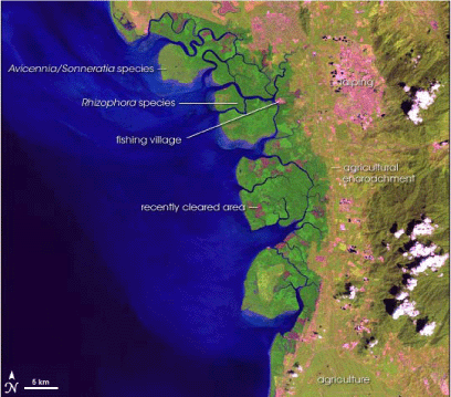
Figure 3. Matang mangroves situated on a macrotidal delta in Kedah, Malaysia. These mangroves constitute a shorefront vegetation belt about 110 km long and about 30 km wide. NASA Earth Observatory: http://earthobservatory.nasa.gov/Newsroom/NewImages/images.php3?img_id=17464
The Matang mangroves rank among the best managed in the world. About 20 villages, mostly engaged in fishing, are situated at the inner periphery of the forest reserve. If longevity is a measure of sustainability, the Matang mangroves are an outstanding example of sustainable coastal land use. Designated as a reserve in 1902, it has retained its character for more than a century. The rapid loss of mangroves and mangrove-dependent livelihoods is lamented at most other locations in tsunami-affected Asia. Some distance to the north of Matang, at Merbok, rapid depletion of mangroves under pressure from urbanization has been reported (Haywood et al. 2001).
The Matang mangroves have been managed for wood production since 1902. Management is based on ten-year working plans aimed at providing quality timber. The major species supporting the fishery in the Matang forest include the mud crab (Scylla serrata) and the cockle (Anadara granosa). Cage culture of the sea bass (Lates calcarifer) is also a profitable activity.
|
Box 4. Diversity of mangrove formations Mangrove planting and protection are promoted in the tropics as a panacea for problems of coastal productivity and — after the tsunami — as a protective barrier (e.g. UNEP 2005; IUCN 2006). Therefore answers are required to a few critical questions to prevent misplaced interventions that could cause serious short- and long-term damage. Q:
How do mangrove formations differ? Their magnitude varies from massive formations such as the Sunderbans in Bangladesh (about 5 000 square kilometres in extent) to strip patches of less than a hectare. Tidal amplitude in the former is in excess of four metres. The latter occur typically within partially enclosed estuaries, backwaters, creeks and lagoons where the tidal range is less than one metre and sediment supply is low. Under such situations shorefront mangroves cannot develop — e.g. in Sri Lanka, parts of India and Indonesia. The vast mangrove formations occur typically on the deltas of massive rivers e.g. the Ganges–Brahmaputra (Sunderbans — India and Bangladesh), Krishna–Godavari (India), Irrawady (Myanmar), Mekong (Thailand) and to a lesser extent Matang mangroves (Malaysia) and comparable deltaic formations in Sumatra, Indonesia. They typically occur at the shorefront (Figure 3 and below Krishna–Godavari, Sunderbans).
Q:
Which mangrove formations provide protective barriers? Q:
Can, deltaic shorefront mangroves be replicated by human beings? Q:
Can strip mangrove formations protect against coastal hazards? Q:
Can strip mangroves be made by human beings? Q:
Is there any example of a fishery being destroyed by mangroves expanding into
the waterbody, and fisherfolk job loss? Q:
Why is so much money being spent on mangrove green belts as a part of ICM? |
3.4.2 Ecotourism and biodiversity
Concerns exist with regard to the manner in which ecotourism is being promoted. To the extent that the Matang Mangroves Forest Reserve is already managed in an ecologically sustainable way, it may not need an ecotourism industry to boost sustainability. Ecotourism may contribute to the economy of the state by creating demand for tourism-related goods and services outside the site itself. If visitors pay an entrance fee to the “park” to improve services and facilities and to further protect the forests, “true ecotourism” may result.
Over time, working plans focused on forestry where mangrove wood production was the primary objective. These plans did not work for the conservation of mangrove plant biodiversity, fisheries and wildlife resources. The monoculture of Rhizophora apiculata is causing potential loss of other mangrove plant species. From the fishery perspective, the drop in prawn landings (Penaeus merguensis and Parapenaeopsis spp.) and prawn densities in mangrove estuaries is the main concern. Clearly, more sophisticated ICM practices may address the emerging concerns.
3.5 Thailand Land Titling Project (TLTP)
The TLTP case history was selected to illustrate the following:
The case history was developed on the basis of published material; mainly Burns (2004), Bowman (2004), Rusanen (2005), World Bank OED (1999), World Bank (2004) and AusAid http://www.ausaid.gov.au/publications/pdf/quns20pdf
3.5.1 Setting
The TLTP was implemented in the north, northeast, centre and the south of Thailand in stages, continuing a process that had already been initiated by the government based on existing policy. The first phase began in nine provinces in the north and northeast (Figure 4). During completion of the second and third phases, the central parts and the south were included. The southern section with its heavy covering of rubber trees was targeted for completion in 2004 (present status not included here).
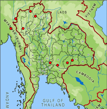
Figure 4 , The nine provinces marked in red with province numbers in parentheis where the TLTP was initiated: Chiang Mai (7), Chiang Rai (8), Phayao (37), Lamphun (17/18), Mae Hong Son (21), Nakhornrachasima (26), Buriram (2), Sisaket (58) and Surin (63).
3.5.2 Strong policy framework and embedding
Historically, land in Thailand belonged to the monarch. As land was freely available, there were few restrictions on those who were prepared to clear and develop it. In 1872, King Chulalongkorn established the Department of Lands (DOL). A titling system was introduced in 1901. By the 1960s one million titles had been issued. The DOL responded to increasing demand with numerous initiatives. From 1975 to 1985, 7.4 million certificates of utilization (a category immediately below a title deed) were issued. By the mid-1980s there were about 4.5 million titles. The TLTP was embedded into this process in 1984.
By 1982 the population of Thailand had increased to about 48 million. At that time 79 percent of the occupants of about 24 million hectares had documents and claims. The remaining 21 percent were illegal occupants of forest land. The existing technical capacity of the DOL indicated that about 200 years would be required to issue titles to all eligible landholders.
The TLTP (i) accelerated title deed issuance; (ii) enhanced production of cadastral maps in rural and urban areas showing all land parcels; (iii) improved the effectiveness of land administration at both central and provincial levels; and (iv) strengthened the Central Valuation Authority.
3.5.3 Long-term strategy
The TLTP started in 1984, based on a clear 20-year plan. The Royal Thai Government (RTG) obtained financial support from the World Bank and the Australian Government, starting in late 1984, for the first three five-year phases. The RTG, with its own funds, was expected to complete the fourth phase in 2004.
3.5.4 Capacity of the national agency — the DOL
The technical capacity of the DOL developed rapidly. Its manual title registration system, accompanied by a dealings file for each land parcel linked to surveys and maps prepared under the TLTP, provided a strong foundation. The DOL headquarters was strengthened by the establishment of a network of provincial branch offices. The register of about 4.5 million titles in 1984 increased to 19 million by 1999 (end of the third phase). The unit cost of title production in 2001 was about US$27. Disputes were resolved almost entirely in the field; very few cases had to be referred to the courts system. The efficiency of service delivery by the DOL is reflected in the increase of titles.
3.5.5 Interagency cooperation and poverty reduction
The relevant collaborating agencies included, inter alia, the Forest Department, the Agriculture Department and the Central Valuation Authority. The TLTP was regarded as an outstanding success story of interagency cooperation and received the World Bank Award for Excellence in 1997. The benefits related to poverty reduction identified by a number of studies conducted by the World Bank and by Kasetsart University in 1990, 1993 and 2002, among others, included:
3.5.6 Conflict with customary land rights of the landless
An estimated population of 12 million including hill tribes and people living under various forms of communal tenure has not received legal recognition. This population mainly occupies parts of Thailand (> 50 percent), which were reserved as forest in the 1960s. Evidently there has been significant encroachment into forests. Studies show that only 20 to 30 percent of the country is actually covered by tree canopy. This population cannot benefit from land titling until appropriate policy modifications are made. The issue of who has the right to access land, and how these rights are distributed and enforced, is a fundamental question concerning social, cultural and economic equality and power. The involvement of bilateral aid (e.g. AusAid) and multilateral financing (e.g. the World Bank) and other corporate interests in land titling needs to be viewed critically, particularly as the focus shifts toward customary land tenure (Rusanen 2005).
3.5.7 Alternative agendas for financial assistance
Australian aid watchdog organizations (NGOs) such as AIDWATCH (Rusanen 2005) provide critical assessments of the TLTP in contrast to the numerous laudatory reviews by the World Bank and AusAid. BHP Engineering, a mining corporation, was the contractor for the TLTP. Is this corporate interest linked to securing easier access to commercialized land and resources? The underlying suggestion is that land registration and commercialization of land would facilitate corporate land capture for mineral exploitation.
3.6 Participatory management of Bunakan National Park (BNP), Indonesia
This case history is presented because of the increasing significance of MPAs as a necessary mechanism for conservation of fishery resources. It is based on Salm et al. (2000) and White et al. (2005). It illustrates that:
3.6.1 Setting
BNP is situated about 15 kilometres off the coast of Manado, the provincial capital of North Sulawesi, Indonesia. It is an 89 000-hectare reserve including six islands and part of the mainland coastline (Figure 5). The associated local population in the late 1990s was 20 000. This population traditionally depended on marine resources for livelihoods. It is an area of exceptional scenic beauty and biodiversity value.
Figure 5. Bunakan National Park in North Sulawesi, Indonesia (Source: IUCN Sri Lanka)
3.6.2 Management
Management of BNP was established in 1997 with a staff of 78. This coincided with the country’s economic crisis and serious budget cuts. The operating budget was about US$80 000 per year. Management is facilitated through participation and strategic partnerships with local communities, the private sector and government agencies. It has established multiple uses and stakeholders with competing interests. Some balance has been established among the rights and responsibilities of the stakeholders. Multistakeholder participation is essential in a situation where corruption is high, government allocations are limited and law enforcement patchy. BNP management has been able to adapt to changing pressures over time.
3.6.3 Evolution of management
The existing participatory management has evolved gradually. The main section of BNP was declared a provincial park in 1980, followed by a southern coastal section in 1984. Both areas were combined and declared as the BNP in 1991. Two activities followed:
Early planning, which conspicuously excluded the local communities, involved the three financially and politically powerful stakeholders — the Ministry of Forestry of the central government, North Sulawesi provincial government and the tourism industry, represented by diving operators.
As management implementation started the authorities soon realized that:
The participation of local communities in management could no longer be avoided.
3.6.4 Technical foundation — zoning
The initial zoning plan (1980s) was designed to support tourism and to safeguard reef ecology. The subsequent zoning strategy incorporated the practical realities of resource use. Thus the local communities were included in design, implementation and monitoring of the zoning plan.
3.6.5 ICM
ICM activities started when BNP was declared a national park in 1991. A 25-year management plan was developed. Many aspects of this plan have been revised and developed including, success in strengthening the park’s enforcement system, establishing a sustainable financing mechanism and conducting a participatory re-zonation process. Nevertheless, conflicts between park management and traditional resource users remain.
3.7 The decisive factors
All of the aforementioned case histories illustrate a mixture of outcomes related to poverty and the environment. The mixture of outcomes is directly and indirectly associated with a range of inputs. Rational behaviour of the more concentrated actor is inevitably present as a powerful and underlying driver. The operation of decisive factors therefore cannot be isolated and replicated in a separate geographic and socio-political setting. The significant decisive factors are:
3.7.1 Physical geography
The contribution of altered physical geography is illustrated by case histories 3.1 and 3.3. It contributed directly to outcomes favourable to economic growth, well-being of the associated poor and some aspects of environmental improvement. Polderization in coastal Bangladesh is an outstanding illustration. The outputs that resulted in sustained benefits are disproportionately larger than the inputs. There were several trade-offs, both foreseen and unforeseen, because the intervention was primarily a physical engineering activity. Today the significant majority of polder residents demand investment in maintaining the embankments and the water control structures. In case history 3.3 physical geographic change occurred in one component of the zoning plan. The landfill constituting the mixed urban zone contributed to investment that has created jobs and improvement of housing for the landless poor. The housing assets have stimulated a range of investments by the recipients leading to substantial increase in property value.
3.7.2 Sustained investment capital
Government policy backed by investment financing, both foreign and domestic, over a sufficiently long period of time is the factor that contributed to complete or partial achievement of planned outcomes. In case histories 3.1, 3.5 and 3.6 the outcome has benefited the poor segment of the associated population directly (Thailand) or indirectly (Bangladesh and Indonesia). In case history 3.3 the entire process, lasting about 15 years, was driven by foreign investment, mainly donor assistance. The initiation of land-use change, except in the case of the Matang Mangroves Reserve, occurred on the basis of policy which was translated into action by the commitment of investment capital. The foreign commitments were shaped by a range of humanistic and self-interested expectations.
The Bangladesh Government recognized the need to increase agricultural production in the face of a growing population in the coastal area. Implementation was based upon funds being made available from the Government of East Pakistan (prior to independence). The sub-factors that provided momentum included the emergence of Bangladesh as an independent nation in 1971 after a costly war, the impact of frequent coastal hazards and long-term interest of donors, and sustained financial support spanning more than four decades (PDO-ICZMP 2005).
3.7.3 Misplaced technology
The fishery modernization policy of the Government of India, sustained by investment by the UN–Norwegian Fishery Project in Kerala spanning a period of several decades, enabled introduction of mechanized trawler fishing. As planned, the trawlers operated from a fishery harbour and boosted total production by several hundred thousand tonnes per year while destroying benthic ecology. The implanting of technology from a northern European context to a southern tropical context without adequate consideration of spatial diversity has been well analysed by Kurien (2005).
The recommendations for fishery development for Sri Lanka (then Ceylon) by a team of fishery experts, three from Europe, one Indian and a Sri Lankan, in the late 1940s provides an interesting comparison (Government of Ceylon 1951). The Indian recommended no more than two medium-size trawlers based upon the character of the continental shelf and the existing fishery. The others upheld investment in a larger fleet based upon technical arguments from a European perspective. The integrity of the Minister of Fisheries was subsequently challenged in parliament regarding trawler purchases from Europe. The trawler fishery in Sri Lanka did not take off owing to a combination of factors.
Case history 3.2 also illustrates the manner in which technology promotion without a sound scientific basis and a regulatory environment leads to unbalanced competition for resources. In it the financially weaker players, the small-scale fisherfolk, lose and plunge into deeper poverty.
3.7.4 Political power
Case histories 3.2, 3.3 and 3.6 illustrate the role of political power (see 3.2 for a definition) in acquiring a response favourable to small-scale, traditional livelihood from governments that have aligned with opposite interests. In such power relations the only countervailing group capacity to resist imposed change is the demonstration of collective voter strength. In case histories 3.2 and 3.3 the effectiveness of countervailing power is illustrated. The same case histories also show that the elected political authorities will seek to dilute collective power tactically by mechanisms that deliver faction-based rewards (caste, religion, etc.). Nevertheless, political power based upon occupational identity, scientific knowledge and financial support (where possible) can thwart the implementation of ill-founded policy and resource allocations.
3.7.5 Policy for accelerated tenure interventions
Centralized land administration is desirable for regulating land uses conducive to sustainable development, while the establishment of the technical capacity for it in the Asian tsunami-affected countries may take decades or even centuries (Williamson 2002). Land and tenure reforms on the other hand are a political process where policies can be devised by the government to reduce poverty and prevent encroachment into protected forests by landless farmers (Williamson 2002; Wily 2005). Case history 3.5 illustrates the manner in which land titling can be used as a mechanism for providing property rights in a relatively short period.
The conclusions are presented in two classes. General conclusions and those derived from the case histories. The author is mindful that some conclusions, for example physical changes to coastal areas, bioshields, misplaced technology, deviate from the “Guiding Principles for Post-tsunami Rehabilitation and Reconstruction” developed by experts at the UNEP meeting held in Cairo on 17 February 2005. Hopefully this disparity will be useful in re-examining these earlier guidelines.
4.1 General conclusions
4.1.1 Land-use trade-offs
The pattern of development and land uses in the coastal areas generally is tilted toward incentives and benefits for investors backed by global financial flows. Here the coastal communities that depend upon the productivity of natural resources, being the weakest set of actors, are the losers. This trend may be stopped, if not reversed, only by investing directly in the well-being of these communities as envisaged in the UN MDGs (Sachs 2005). The major contribution of ICM, in partnership with NGOs, could be educating and organizing coastal communities to enable them to acquire countervailing political power adequate to compel the political leadership to make balanced decisions (Korten 1990; 1995).
4.1.2 Application of remittances for social development
The estimated magnitude of donor funds required for investment towards achieving the MDGs in South Asia where poverty is most serious was US$22 billion in 2006, rising annually to US$36 billion in 2015 (Sachs 2005). On average South Asia already receives US$10 billion annually which goes mainly to increase household consumption. Analysts recognize the vast potential here for both increasing the level of formal remittances as well as investment in developing the capacity of the populations represented by the emigrant workers (Jongwanich 2007). Governments need to develop credible mechanisms that can win the trust of emigrant workers that their remittances benefit their own families. Clearly, the South Asian tsunami-affected countries already have the means to reduce poverty in keeping with the MDGs. Only genuine political leadership and commitment appear to be lacking.
4.2 Conclusions related to case histories and lessons
4.2.1 Physical geography — saving lives and property
The coastal embankments (polders) in Bangladesh, built to enhance agriculture, additionally protect life and property (case history 3.1). Shelters and early warning systems enhance the role of embankments. The gradual and cumulative establishment of the embankment system, spanning a period of four decades, has also placed Bangladesh in a relatively advantageous position for adaptation to more frequent storms associated with climate change. The role of physical geography in saving lives is supported by observations on the natural relationship between the sites of impact and the damage caused by the 2004 tsunami in Sri Lanka (Samarakoon et al. 2005).
Sieh (2005) argues on the basis of strong science that Indonesia will face a series of hazards associated with the Sumatran fault during the coming decades that will have to be addressed with urgency. His plea is fortified by the impact of the tsunami that struck Java 18 months after the 2004 tsunami. The Pacific Tsunami Warning Center in Hawaii issued a warning that a tsunami wave could be generated 17 minutes after detection. Local officials at Australian-controlled Christmas Island saved lives by moving 300 residents to high ground from low-lying parts of the island. By 16.15 (local time), a two-metre-high tsunami hit the southern coast of Java. An estimated 525 people died, hundreds were missing and some 500 were injured. More than 50 000 people fled their coastal villages as their homes were devastated (Roberts 20 July 2006 <wsws.org>; FAO 2006). Indonesia’s only sensor in Cilacap had sent a warning in “real time” to the Meteorological and Geophysical Center in Jakarta. An agency official had later stated that no public warning had been issued because they “were busy monitoring all the aftershocks” (Roberts 2006).
Hazards stemming from anticipated sea-level rise may warrant consideration of the physical geography of exposed coastal areas for gradual and progressive investment for adaptation in all Asian tsunami-affected countries (HM Treasury 2006).
|
Lesson 1. |
Alteration of physical geography at exposed coastal locations in Sumatra in particular coupled with the other recommendations by Sieh (2005) is a priority. |
|
Lesson 2. |
Interventions involving alteration to physical geography in the Asian tsunami-affected countries may be done strategically. Step 1: Map the coastline according to coastal vulnerability indices (CVIs). Step 2: Prioritize coastal segments to optimize efficiency. Step 3: Plan and implement interventions incorporating adaptation against the probable impacts of sea-level rise. |
4.2.2 Long-term financing
The availability of capital for appropriate periods of time to achieve change, whether desirable or undesirable, is a shared feature among all the case histories. Any vision for long-term benefits from ICM and post-tsunami reconstruction has to realistically include the parallel contributions from courage to face an unforeseen future and the supportive investment capital.
|
Lesson 3. |
Sources of funding need identification and financial commitments acquired for appropriate time spans (decades and more). |
4.2.3 Misplaced technology
Case histories 3.2, 3.3, 3.4 and 3.6 demonstrate the consequences of generalizing technology without recognizing the ecological character of particular locations.
|
Lesson 4. |
Technology for a particular geographic location must be identified through multidisciplinary, intersectoral consultation and scientific analysis (natural and social science methods) coupled to the aspirations and expectations of local resource users. |
4.2.4 Political power
Political power (see 3.2 for definition) operated as a decisive factor in case histories 3.2, 3.3 and 3.6. It became operative and demonstrable where collective identity was forged. In case histories 3.2 and 3.3 political power dissipated with the fragmentation of collective identity. In case history 3.6 the identity of the traditional fisherfolk has been maintained. Three lessons emerge:
|
Lesson 5. |
Political power may be acquired through the development of collective occupational identity, networking and by strengthening self-awareness. |
|
Lesson 6. |
NGO support to organize and negotiate with authorities (e.g. International Collective in Support of Fishworkers) is indispensable. |
|
Lesson 7. |
Government support is required if the financially weak coastal resource users are to reduce their poverty by way of implementing enabling policies. |
4.2.5 Policy for tenure reform
Poor coastal communities must enter as empowered partners into the triangle of societal forces that shape economic growth: government, civil society and markets. Asset-less segments of society have only the power of their numbers. A factor that can contribute to strengthening of coastal communities is to award them tenure rights over necessary land and resources. Case history 3.5 demonstrates that this can be achieved in relatively short periods in the event that appropriate policy is implemented (also see case histories 3.2 and 3.3).
|
Lesson 8. |
The effective mechanism for empowerment of coastal communities is to provide private or collective tenure/property rights to enable participation in markets. |
4.2.6 Science as the beacon
Coastal vulnerability indices (CVIs)
ICM seeks to combine science with management (see aforesaid definition, GESAMP 1995). During the assessment of tsunami damage to coastal ecosystems in Sri Lanka (Samarakoon et al. 2005) a major impediment to analysis was the absence of scientific indicators for coastal vulnerability in Sri Lanka. The same situation exits in other Asian tsunami-affected countries. The United States is guided in its preparation for coastal hazards and sea-level rise by CVIs established through scientific analysis and mapping (e.g. NOAA http://www.ncddc.noaa.gov/cra/AssessmentTools/hazardoverview). Allocation of resources for protective measures is therefore highly efficient. USAID has been the leading agency promoting ICM in the region for almost three decades, but CVIs have not been established.
Professor Kerry Sieh, California Institute of Technology, is arguably the person with the most reliable scientific knowledge about earthquakes and the capability to convert this knowledge to practical mitigation measures; based upon his experience with communities in Sumatra prior to the earthquake, he states that simple science-based approaches may save more lives (Sieh 2006).
|
Lesson 9. |
Mapped CVIs should be established for coastlines known to be exposed to multiple hazards to enable efficient allocation of resources for ICM and as a climate change adaptation strategy. |
Bioshields and green belts
Vegetation belts are promoted as defensive barriers against coastal hazards. A study from Tamil Nadu (Kathiresan and Rajendran 2005), shortly after the tsunami, reported that human deaths and property losses were lower in coastal hamlets fronted by mangroves. The same data re-analysed, demonstrated that the link to mangroves was false and that elevation above sea level and distance from the sea provided the simplest and most scientifically verifiable explanation (Baird 2006; Kerr et al. 2006). The nature of mangroves is highly diverse and depends upon a combination of factors (see case history 3.4). Sometimes they can do more harm than good in terms of ecosystem functioning (see case history 3.3). A technical definition of mangrove bioshields and green belts appears to be unavailable in post-tsunami statements. A minimum operational definition should include, inter alia: species, tidal amplitude, sediment yield in the associated waterbody, level of enclosure (barrier built estuary, bay, delta, etc.), width and length. Soerianegara (1986) provided technical guidelines for mangrove green belts and recommended a width of at least 300 metres.
|
Lesson 10. |
Where mangrove green belts are being implemented, the national authorities must exercise caution. The implementing organizations must be accountable for adverse side-effects for a minimum period of 20 years. |
Acknowledgement
The patient support provided by Mr Jeremy Broadhead (FAO), assistance from the FAO office Sri Lanka, which provided access to library facilities and financial support for participation at the workshop in Bangkok are appreciated. Professor Seneviratne Epitawatte, Department of Geography, Sri Jayawardenapura University, Sri Lanka provided valuable assistance in discussing various aspects of the paper to ensure a multidisciplinary perspective.
Bibliography
Abdelal, R. & A. Segal. 2007. Has globalization passed its peak? Foreign Affairs, 86(1): 103–114.
ActionAid International. 2005. Tsunami response, a human rights assessment. Report prepared by PDHRE, People’s Movement for Human Rights Learning. Web pages http://www.actionaid.org ; http://www.pdhre.org
Asian Development Bank (ADB). 2005. Asian environmental outlook 2005. Making profits, protecting our planet: corporate responsibility for environmental performance in Asia and the Pacific. Manila, Asian Development Bank.
Adger, W.N., Hughes, T.P., Folke, C., Carpenter, S.R. & J. Rockström. 2005. Social-ecological resilience to coastal disasters. Science, 309 (5737): 1036–1039.
Ambio. 1988. East Asian Seas. Ambio, 17(3): 1988.
Australian Agency for International Development (AusAID). 2004. Thailand: land titling. Reducing Poverty and Sustaining Growth. Scaling Up Poverty Reduction. A Global Learning Process and Conference, Shanghai, 25–27 May 2004. Case study summaries, World Bank, 2004. pp. 242–245.
Ayob, A.M. (undated). Mangroves and ecotourism: Ecological or economical? http://mahdzan.com/papers/mangrove/mangrove.asp.
Ayyappan, R. 1998. The forgotten fishermen of Kasba, Kerala. Rediff.com Feb 5, 1998. http://www.rediff.com/index.html
Baird, A.H. 2006. Myth of green belts. SAMUDRA Report No. 44 July 2006: pp. 14–19.
Barry, G. 2001. Serious concerns regarding forest certification. Forests.org. July 14, 2001 http://borneoproject.org/article.php?id=505
Barry, G. 2004. Reject Malaysia’s attempt to greenwash its timber practices. Forest Conservation blog. http://forests.org/blog/2004/02/reject_malaysias_attempts_to_g.html
BBC News. 11 June 2005. Logging threatens Borneo species.
http://news.bbc.co.uk/1/hi/world/asia-pacific/4083016.stm
BCAS-Bangladesh Center for Advanced Studies. 2001. Bangladesh: state of the environment 2001 – Natural Disasters. pp. 93–101. www.bcas.net/Publication/SoE/Natural%20Disasters.pdf
Borras, S.M. Jr. 2005. Can redistributive reform be achieved via market-based voluntary land transfer schemes? Evidence and lessons from the Philippines. The Journal of Development Studies, 41 (1): 90–134.
Bowman, C. 2004. Thailand Land Titling Project. Case study prepared for AusAID. Reducing Poverty and Sustaining Growth. Scaling Up Poverty Reduction. A Global Learning Process and Conference, Shanghai, 25–27 May 2004. Copyright World Bank, 2004. Burns, A. 2004. Thailand’s 20 year program to title rural land (draft, 13 February 2004). Background paper prepared for the World Development Report 2005.
Carney, D., Drinkwater, M., Rusinow,T., Neefjes, K., Wanmali, S. & N. Singh. 1999. Livelihood approaches compared. UK, DFID (Department for International Development).
CCD. 1997. Revised coastal zone management plan for Sri Lanka 1997. Maligawatte, Colombo.
Coast Conservation Department.
Cecin-Sain & Knecht. 1998. Integrated coastal and ocean management: concepts and practices. Island Press. 517 pp.
Central Environmental Authority–ARCADIS–Euroconsult. 2006. Building interactive societal terrain for environmental management. Battaramulla, Central Environmental Authority.
Central Environmental Authority-Euroconsult. 1994. The conservation management plan for Muthurajawela and Negombo Lagoon. Battaramulla, Central Environmental Authority.
Cesar, H.J.S. (ed). 2000. Collected essays on the economics of coral reefs. CORDIO–Sweden, 244 pp.
Chapin, M. 2004. A challenge to conservationists. World Watch Magazine, November/December 2004: 17–31. http://www.worldwatch.org/node/565
Chattopadhyay, S. 2005. Integrated coastal zone management actionplan of Mararikulam area: a discussion note. 131–43.
De Soto, H. 1990. The other path: the invisible revolution in the third world. New York, Harper and Row.
De Soto, H. 2000. The mystery of capital: why capitalism triumphs in the west and fails everywhere else. Bantam Press.
De Ven,V. (ed). 1993. Man-made lowlands: history of water management and land reclamation in the Netherlands. Uitgeverij Matrijs, the Netherlands. 293 pp.
Deshpande, R.S. 2002. Country case study, India. Presented at the Regional Workshop on Land Issues in Asia. Phnom Penh, Cambodia: 4–6 June 2002, World Bank Group. Available from http://lnweb18.worldbank.org/ESSD/ardext.nsf/24ByDocName/India
Diamond, J. 2005. Collapse: how societies choose to fail or survive. London, Penguin Books Ltd. 575 pp.
Dissanayake, T. 2006. Sale or sell out? Sri Lanka’s farmers and land reform. PANOS London Online. http://www.panos.org.uk/global/featuredetails.asp?featureid=1234&ID=1022
Down to Earth Indonesia. 2003. Shrimp business destroys mangroves and livelihood. Down to Earth, 58, August 2003. http://dte.gn.apc.org/58mar.htm
Easterly, W. 2002. The elusive quest for growth: economists’ adventures and misadventures in the tropics. Cambridge, Massachusetts, MIT Press. 342 pp.
Easterly, W. 2006. Oped: dismal science. Wall Street Journal, 15 November 2006. http://www.nyu.edu/fas/institute/dri/Easterly/SachsDebates.htm
Economist. 2004. Going for the jugular. 10 June 2004.
EJF: Environmental Justice Foundation. 2003. Smash & grab: conflict, corruption and human rights abuses in the shrimp farming industry. www.ejfoundation.org
Etzioni, A. 1968. The active society: a theory of societal and political processes. New York, Free Press.
FAO. 2000. Sustainable contribution of fisheries to food security. RAP publication 2000/23. Bangkok, Thailand, FAO Regional Office for Asia and the Pacific.
FAO. 2004. The state of world fisheries and aquaculture. Rome, FAO.
Fitzpatrick, L. 2006. Awash in trash. Time International, 2 October 2006.
Franke, R.W. 2005. The Mararikulam experiment: an international perspective. 176–82.
Friedman, T.L. 2005. The world is flat. New York, Farrar, Strauss and Giroux. 488 pp.
Fuller, T. 2001. Criticism of 30-year-old affirmative-action policy grows in Malaysia. International Herald Tribune, Friday, 5 January, 2001.
http://www.iht.com/articles/2001/01/05/kuala.2.t.php
Gallopin, G.C. 2006. Linkages between vulnerability, resilience and adaptive capacity. http://www.elsevier.com/locate/gloenvcha
GCEC-Euroconsult. 1991. The master plan for Muthurajawela Marsh and Negombo Lagoon. Colombo, GCEC (Board of Investment, Sri Lanka).
GESAMP (IMO/FAO/UNESCO-IOC/WMO/WHO/IAEA/UN/UNEP Joint Group of Experts on the Scientific Aspects of Marine Environmental Protection). 1996. The contribution of science to integrated coastal management. Rep. Stud. GESAMP, (61): 66.
Government of Ceylon. 1951. Ceylon fisheries: recommendations of experts on fisheries development, research, socio-economic and industrial problems. Sessional paper VI, 1951. Colombo, Government Publications Bureau.
GPA. 2005. Ecosystem based management: markers for progress. UNEP Global Programme of Action for the Protection of the Marine Environment from Land-based Activities (GPA). http://www.gpa.unep.org/documents/ecosystem-based_management_english.pdf
Hameed, F. and Ali, M. 2001. An overview of coastal stewardship in the Maldives. Paper presented at the workshop on ‘Furthering coastal stewardship in small islands”, 4–6 July 2001, Dominica. http://www.unesco/csi/pub/papers2/domp11.htm
Harford, T. 2006. The undercover economist. UK, Little Brown. 278 pp.
Hasbullah, S.H., Balasundarampillai, P. & K.T. Silva. 2005. Addressing root causes of the conflict in north-east Sri Lanka. UNHCR and FCE, Colombo. 106 pp. Available from www.fcoex.com
Haywood, M.D.E., Manson, F.J., Lonergan, N.R., Gong, W.K. & J.E. Ong. 2001. Estimating changes in extent of mangroves in a Malaysian estuary. Paper presented at the Asian Wetland Symposium, 27–30 August 2001, Penang, Malaysia.
Hemmati, M. & N. Koehler. 2000. Financial leakages in tourism. Sustainable Travel & Tourism. pp. 25–29.
Hewitt, G. 2006. Deep frustration in New Orleans. BBC News. http://news.bbc.co.uk/1/hi/world/americas/5293836.stm
Hiroshi Kakazu, Min Tang & Myo Thant (eds). 1998. Growth triangles in Asia: a new approach to regional economic cooperation (second edition).
HM Treasury. 2006. Stern review on the economics of climate change. http://www.hm-treasury.gov.uk/independent_reviews/stern_review_economics_climate_change/stern_review_report.cfm
Hooi, T.K. 2006. Challenges to sustainable management and development of mangrove resources in Matang, Perak, Malaysia. East Asian Seas Congress, 2006. http://www.pemsea.org/eascongress/docs/sessions/abstracts/3_habitat_mgt_Tan_Mangrove_Malaysia.pdf
Hossain, M., Bose, M.L., Chowdhury, A. & R. Meizen-Dick. 2002. Changes in agrarian relations and livelihood in rural Bangladesh: insights from repeat village studies. A paper prepared for the International Conference on Agrarian Relations and Rural Development in Less Developed Countries. Kolkata, West Bengal, India, 3–6 January 2002.
Islam, M.R. 2004. Where land meets the sea: A profile of the coastal zone of Bangladesh. PDO-ICZM-WARPO. Dhaka, Bangladesh, the University Press Ltd. 317 pp.
Islam, M.R. 2006. Toward institutionalization of global ICZM efforts (draft paper). Author’s e-mail: [email protected]
Institute of Development Studies (IDS). 2003. The rise of rights: rights-based approaches to international development. Institute of Development Studies IDS Policy Briefing Issue 17, May 2003. http://www.ids.ac.uk/ids
International Tropical Timber Organization (ITTO). 2006. Status of tropical forest management 2005 — summary report. International Tropical Timber Organization — ITTO Tropical Forest Update (2006/1). www.itto.or.jp
Jongwanich, J. 2007. Workers’ remittances, economic growth and poverty in developing Asia and the Pacific countries. Bangkok, UNESCAP Working Paper WP/07/01. ([email protected]).
Kathiresan, K. & N. Rajendram. 2005. Coastal mangrove forests mitigated tsunami. Estuarine, Coastal and Shelf Science, 65: 601–606.
Kerr, A.M., Baird, A.H. & S.J. Campbell. 2006. Comments on Kathiresan and Rajendran. coastal mangrove forests mitigated tsunami. Estuarine, Coastal and Shelf Science, 67: 539–541.
Korten, D.C. 1990. Getting to the 21st century: voluntary action and the global agenda. Kumarian Press.
Korten, D.C. 1995. When corporations rule the world. Kumarian Press.
Kurien, J. 2002. People and the sea: a ‘tropical-majority’ world perspective. Maritime Studies MAST, 1(1): 9–26.
Kurien, J. 2004. The blessings of commons: small scale fisheries, community property rights, and coastal natural assets. Political Economy Research Institute (PERI), Working Paper Series 72. University of Massachusetts, Amherst. 27 pp.
Kurien, J. 2005. Evolving toward unsustainability: A personal statement on Kerala’s marine fishery spanning three decades. International Journal of Rural Management, 1: 73 http://irm.sagepub.com/cgi/reprint/1/1/73
Liyanage, S. 1986. Review of mangrove related activities in Sri Lanka. Symposium on New Perspectives in Research and Management of Mangrove Ecosystems, Colombo, Sri Lanka 11–14 November 1986. UNDP/UNESCO Regional Mangroves Project RAS/79/002.
Macfadyen, G. & E. Corcoran. 2002. Literature review of studies on poverty in fishing communities and of lessons learned in using the sustainable livelihoods approach in poverty alleviation strategies and projects. FAO Fisheries Circular No. 979 FIPP/C979. Rome.
Mascarenhas, A. 1999. The coastal regulation zone of Goa: oceanographic, environmental and societal perspectives. National Institute of Oceanography, Goa, India. http://www.ias.ac.in/currci/dec251999/article16.htm
McGoodwin, J.R. 2002. Better yet, a global perspective? Reflections and commentary on John Kurien’s essay. Maritime Studies MAST, 1 (1): 31–41.
Narayan, D. & Petesch, P. (eds). 2002. Voices of the poor from many lands. World Bank, Oxford University Press.
Obama, B. 2006. The audacity of hope – thoughts on reclaiming the American dream. Crown Publishers, New York. 375 pp.
OECD & Directorate for Science, Technology and Industry Steel Committee. 2006. India: steel-making raw materials, issues, policy and outlook. DSTI/SU/SC(2006)31, 12 May 2006.
Ostrom, E., Burger, J., Field, C.B., Norgaard, R.B. & P. Policansky. 1999. Revisiting the commons: local lessons, global challenges. www.sciencemag.org
Panayotou, T. 1982. Management concepts for small scale fisheries: economic and social aspects. FAO Fisheries Technical Paper No. 228: 53 pp.
Programme Development Office–Integrated Coastal Zone Management Plan (PDO–ICZMP). 2005. Drainage issues in the coastal zone. Government of Bangladesh, Ministry of Water Resources, Water Resources Planning Organization (WARPO). http://www.iczmpbangladesh.org/rep/wp45.pdf
Polman, W. 2004. Local participatory governance in support of pro-poor rural enterprise development in Asia and the Pacific. Rural Development Officer, FAO Regional Office for Asia and the Pacific, Bangkok. Available from: http://www.icarrd.org/en/ref_doc_down/rurald_Participatory_local_governance_rural_enterprise_development_Land_Reform_CoopbulletinNov_11.doc
Primavera, J.H. 2000. Integrated mangrove-aquaculture systems in Asia. Integrated Coastal Zone Management, Autumn 2000: 121–128. http://mangroveweb.seafdec.org.ph/html/fresourc.ht
Prosterma, R.L. & T. Hanstad. 2000. Land reform: a revised agenda for the 21st century. RDI Reports on Foreign Aid and Development. Seattle, Washington, Rural Development Institute, July 2000.
ProVention Consortium. 2004. Working in partnership to build safer communities and reduce disaster risk (provides literature on a wide range of disaster-related planning topics in developing countries). http://www.proventionconsortium.org/
Ratnayake, R.M.K. 2002. Country case study, Sri Lanka. Presented at the Regional Workshop on Land Issues in Asia, Phnom Penh, Cambodia: 4–6 June 2002, World Bank Group. Available from http://lnweb18.worldbank.org/ESSD/ardext.nsf/24ByDocName/Srilanka
Roberts, J. 2006. Population given no warnings as tsunami hits Java, killing hundreds. World Socialist Web site (wsws.org), 20 July, 2006. http://www.wsws.org/articles/2006/jul2006/tsun-j20.shtml
Royat, S. 2002. Country case study, Indonesia. Presented at the Regional Workshop on Land Issues in Asia, Phnom Penh, Cambodia: 4–6 June 2002, World Bank Group. Available from http://lnweb18.worldbank.org/ESSD/ardext.nsf/24ByDocName/Indonesia
Rusanen, L. 2005. In whose interests? The politics of land titling. Background paper. AIDWATCH, May 2005.Sachs, J. 2005. The end of poverty – how we can make it happen in our lifetime. Penguin Books. 396 pp.
Salagrama, V. 2002. Fish out of water: The story of globalization, modernization and artisanal fisheries in India. http://www.onefish.org/servlet/CDSServlet?status=ND0yNDM3MzMuMjQzODI1JjY9ZW4mMzM9ZG9jdW1lbnRzJjM3PWluZm8~#koinfo 1111124640817_Fish_out_o...08457.pdf
Salm, R.V., Clark, J.R. & E. Siirila. 2000. Marine and coastal protected areas – a guide for planners and managers (third edition). Gland, IUCN.
Samarakoon, J. 2004. Issues of livelihood, sustainable development and governance: Bay of Bengal. Ambio, 33(1–2) February 2004.
Samarakoon, J.I. & H. van Zon., 1991. The ecological profile of Muthurajawela Marsh and Negombo Lagoon. Colombo, Sri Lanka, GCEC-Euroconsult. Board of Investment.
Samarakoon, J.I., Eiptawatte, S. & R. Galappatti. 2005. Assessment of the impact of the tsunami of 26 December 2006 on the coastal ecosystems of Sri Lanka (draft). Ministry of Environment and Natural Resources/UNEP.
Sarker, M.H., Huque, I., Alam, M. & R. Koudstaal. 2003. Rivers, chars and char dwellers of Bangladesh. Intl. J. River Basin Management, 1(1):61–80.
Sathyamoorthy. 2006. CZM and fisheries in Tamil Nadu.
Schultz, T.W. 1979. The economics of being poor. Nobel Prize Lecture, 1979. http://nobelprize.org/nobel_prizes/economics/laureates/1979/schultz-lecture.html
Sieh, K. 2006. Sumatran megathrust earthquakes: from science to saving lives. Phil. Trans. R. Soc. A. 364: 1947–1963.
Soenianegara, I. 1986. The width of mangrove green belt as coastal zone protection forest. Symposium on New Perspectives in Research and Management of Mangrove Ecosystems, Colombo, Sri Lanka, November 11–14 1986. UNDP/UNESCO Regional Mangroves Project RAS/79/002.
Stern, N. 2005. Making development happen: growth and empowerment. Eighteenth Presidential Lecture Series, 27 April 2005. Washington, World Bank. http://www.info.worldbank.org/etools/docs/library/138945/Transcript%20Stern%20042705.doc
Stiglitz, J. 2002. Globalization and its discontents. London, Penguin Books. 282 pp.
Todd, E. 2005. The specter of a Soviet-style crisis. Truthout interview on Hurricane Katrina. Monday 12 September 2005. www.truthout.org/docs_2005/091205H.shtml.
Tourism Concern. 2005. Post-tsunami reconstruction and tourism: a second disaster. http://www.tourismconcern.org.uk
Tuticorin Port Trust. 2005. Final detailed project report – evaluation of EIA study for Sethusamudra Ship Channel Project February 2005. Chennai, India, Rambol Consulting Engineers Ltd.
UNESCO. 2001. A place for indigenous people in protected areas, Surin Islands, Andaman Sea, Thailand.
United Nations Development Programme. 1990. Human development report 1990. New York Oxford University Press (also various years).
Vanucci, M. 1988. The UNDP/UNESCO in Asia and the Pacific. Ambio, 17(3): 214–217.
WCFSD. 1999. Our forests our future – summary report. Canada, World Commission on Forests and Sustainable Development. http://iisd.ca/wcfsd
White, A.T., Martosubroto, P. & M.S.M. Sadorra. (eds). 1989. The coastal environmental profile of Segara Anakan-Cilacap, South Java, Indonesia. ICLARM, ASEAN, USCRMP Technical Publication Series 4.
White, A.T., Christie, P., Agnes, H.D., Lowry, K. & N. Milne. 2005. Designing ICM projects for sustainability: lessons from the Philippines and Indonesia. Ocean & Coastal Management, 48: 271–296.
Williamson, I.P. 2000. Best practices for land administration systems in developing countries. International Conference on Land Policy Reform, 25–27 July, 2000, Jakarta. http://www.eprints.unimelb.edu.au/archive/00001262/01/2_01_ipw_LandAdminBestPractice(JLUP00)2.pdf
Wily, L.A. 2006. Land rights reform and governance in Africa. How to make it work in the 21st century.
Wolowicz, K. 2005. The fishprint of aquaculture. Can the blue revolution be sustainable? Redefining progress. www.rprogress.org/publications/2005/The_Fishprint_of_Aquaculture_1205.pdf
World Bank & OED. 1999. Land administration & rural development: Two cases from Thailand. World Bank Operations Evaluation Department, Spring 1999, No. 184.
World Bank. 2003. Land policies for growth and poverty reduction. Washington, World Bank. 288 pp.
World Bank. 2006. World development report: equity and development. New York, Oxford University Press.
World Bank. 2000, various years. World development report. Oxford University Press.
WHO. 2005. Asian tsunami: situation report 8. Rome, World Health Organization. http://www.who.int/hac/crises/international/asia_tsunami/sitrep/08/en/
Worm, B., Barbier, E.B., Beaumont, N., Emmett Duffy, J., Folke, C., Halpern, B.S., Jackson, J.B.C, Lotze, H.K., Micheli, F., Palumbi, S.R., Sala, E., Selkoe, K.A., Stachowicz, J.J. & R. Watson. 2006. Impacts of diversity loss on ocean ecosystem services. Science, 314(5800): 787–790.
1 Freelance consultant, ARCADIS EUROCONSULT, Arnhem, the Netherlands.
![]()
![]()
![]()