![]()
![]()
![]()
Funakawa, S.1,
Yanai, J.2, Hayashi, Y.1, Hayashi, T.1,
Noichana, C.3, Panitkasate, T.3,
Katawatin, R.3
and Nawata, E.1
Keywords: geostatistical analysis, heterogeneity of soil properties, runoff generation, sloped sandy cropland, soil organic matter dynamics
|
Abstract Sandy soils are widely distributed in Northeast Thailand. We analyzed spatial distribution patterns of soil properties and their possible determining factors on a sloped cropland near Khon Kaen City, Northeast Thailand. Our research site included a sugarcane field on a slope, a mango plantation in the lower slope, a wetland rice field in the lowland, and teak plantation on the opposite slope. In total 116 soil samples were collected from a 510 × 270 m field at a 30-m interval and the spatial distribution patterns of soil properties were evaluated using geostatistical analysis. As a result, a clear spatial variation was observed for soil organic C and N contents, particle size distribution, and their related properties. In the teak and/or mango plantations the soil texture was finer and the contents of C and N were higher than the sugarcane field. Soil organic matter (SOM) dynamics and soil erosion were postulated to be driving forces that could bring such heterogeneity of soil properties in the slope land. The SOM dynamics was analyzed at five representative plots on the slope in terms of topography and land use. Both the SOM stock in the upper 15 cm soil layers and annual soil respiration was higher under the tree vegetation than at the sugarcane plots. Annual soil respiration was high often exceeding 40% of the SOM stock. The SOM was considered to rapidly increase under tree vegetation through litter input. The condition of surface runoff generation, which was usually strongly related to the process of soil erosion, was analyzed on three slopes in Northern and Northeast Thailand using a runoff-gauge connected to a data-logger. The rainfall intensity of the Khon Kaen plot was higher than the other two plots in northern region and the surface runoff occasionally occurred throughout the rainy season with no clear seasonal trend, this not being observed on the other two plots, at which the surface runoff occurred more often during the latter half of the rainy season due to higher rainfall intensity and/or capillary saturation of surface soils. Thus redistribution of soil properties due to SOM dynamics and/ or soil erosion was considered to proceed with ease on the sandy sloped land. It would be more reasonable to adapt agricultural systems to the unique conditions of these agro-ecozones through spatial or site-specific land management rather than to eliminate or decrease the risks of SOM decomposition or soil erosion. |
Introduction
The agro-ecological conditions of Northeast Thailand are characterized by the wide distribution of sandy soils, irregular occurrence of rainfall events during the rainy season, and undulating topography with relatively gentle slopes. These conditions might traditionally have been disadvantageous for agricultural development in the area. Nowadays, after the development of transport infrastructure and domestic/international market economy, market-oriented agriculture is being widely adopted. Rainfed paddy rice in lower slope positions that is primarily for household consumption and sugarcane and/or cassava plantations as commercial crops in the middle to upper slopes are most widely observed especially in the northern half of Northeast Thailand. The humid climatic conditions of the region are conducive for the development of natural forests. It is said that a total of 490 × 106 ha of forest has been cleared for agricultural use during the period of 1961-1998 in the region (Royal Forest Department 1998). Because most of the changes have occurred over the past several decades, the sustainability of agricultural production in near future is not secure.
When considering the sustainability of agricultural production on tropical sandy slopes, both spatial and temporal evaluation of the dynamics of soil resources are required as well as analyses of nutrient budgets and/or erosion risks at a representative plot scale. As a case study, we selected a cropped field extending several hundred-metres in extent on slopes, which included sugarcane fields, tree plantations and wetland rice cultivation. The following analyses were carried out in the present study: 1) analysis of the spatial distribution patterns of soil properties on slopes using a geostatistical technique, 2) evaluation of SOM dynamics under different land uses patterns on the slope and 3) analysis of the processes associated with surface runoff generation in comparison with that in other regions of Northern Thailand.
Geostatistical analysis of spatial variation of soil properties on a sloped sandy agricultural landscape in Khon Kaen Province
1. Materials and methods
Experimental field
The study was carried out on farmer’s fields in Ban Sam Jan, Khon Kaen Province, which was located N 16°35-36′ and E 102°47-48′. The experimental field covered 270 m from southwest to northeast and 510 m from northwest to southeast with an average slope gradient of 5%, and included a sugarcane field on the slope, a mango plantation in the lower slope, wetland rice field at the bottom, and a teak plantation on the opposite slope (Figure 1). Soil was typically sandy (>90% sand fraction) and was classified as a Typic Ustipsamments according to Soil Taxonomy (Soil Survey Staff 2003). The mean annual temperature and precipitation are 27.4°C and 1,190 mm, respectively, at Khon Kaen City (1951-1975).
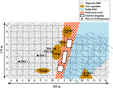
Figure 1. Land use and sampling plots in the SJ study site, Khon Kaen Province
Sampling method
A topographical map was developed by measuring relative elevation at 30 m intervals before the start of rainy season (March) in 2002. At the same time, soil samples were collected as a composite of 5 sub-samples from surface 0-10 cm layers of soil within a 50 cm circular area centred on each position. In total 116 samples were collected. After determination of moisture content of the fresh soils, they were air-dried and passed through a 2 mm mesh sieve prior to chemical analysis consisting of: pH (in water), total C and N (by dry combustion), available phosphate (Bray II method), exchangeable bases, and particle size distribution (by combination of sieving and pipette methods). Soil moisture content was again measured at the end of rainy season of the same year at the same plots.
Statistical analysis
Mean and coefficient of variation (CV) were determined for each soil property. A statistical software SYSTAT 8.0 was used in the analysis (SPSS Inc. 1998). In the geostatistical analysis, a semivariogram was used to evaluate the spatial variability of the properties, representing the relationship between the lag or any integral multiple of the sampling interval and the semivariance. In this study, two indices were used to evaluate the spatial dependence of the soil properties. One is the Q value, which indicates the spatial structure at the sampling scale (Goerres et al. 1997). This value is given by the following equation:

where S and N are the sill and the nugget variance, respectively. The value ranges between 0 and 1. If the value is 0, no spatial structure is detected on the sampling scale used, and as the Q value approaches 1, the spatial structure is more developed and more of the spatial variation can be explained by the semivariogram model on the analysis scale used. The other is the range, which indicates the limit of spatial dependence. In the analysis, the semivariogram model with the greatest r2 value was used for the estimation of the semivariogram parameters. Maps of each property were computed subsequently using block kriging, by taking account of the data within the range distance. Block kriging was used instead of punctual kriging because it enables the evaluation of regional patterns of variation rather than local details, due to the construction of smoother maps with smaller estimation variances. A geostatistical software, GS+ Version 3.1 for Windows (Gamma Design Software), was used in the analysis (Robertson 1998).
2. Results and discussion
According to topographical map in Figure 2, the difference in the elevation was about 15 m along the longest side of the field. The northwestern part was the highest and the relative elevation decreased towards the southeast, reaching a low at the bottom of the slope in the paddy and then again increasing as one moved up the opposite slope. Table 1 summarizes the descriptive statistics, i.e. the mean, maximum, minimum values and CV of the 116 data for physico-chemical properties of the surface soils (0-10 cm) studied. The soils were generally sandy with an average sand content of 93.3%. The clay content varied widely from 0.2 to 6.1% and as a result the contents of total C and N and exchangeable bases also varied with high CV values of greater than 50%, indicating a considerable within-field variability in the study field.
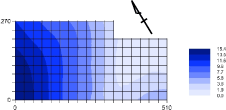
Figure 2. Relative elevation (m) of the SJ study site
Table 1. Descriptive statistics of physicochemical properties of the 0-10 cm depth on soils at the SJ site
| average |
maximum |
minimum |
CVa |
|
| Sand (%) | 93.3 | 98.3 | 81.6 | 3.2 |
| Silt (%) | 4.2 | 13.0 | 0.1 | 54 |
| Clay (%) | 2.5 | 6.1 | 0.2 | 48 |
|
Total carbon (g kg–1) |
3.35 | 13.53 | 1.31 | 58 |
|
Total nitrogen (g kg–1) |
0.29 | 0.87 | 0.05 | 49 |
|
Available phosphate (mg kg–1) |
192 | 861 | 35.0 | 67 |
|
Exchangeable K (cmolc kg–1) |
0.07 | 0.35 | 0.01 | 73 |
|
Exchangeable Mg (cmolc kg–1) |
0.18 | 0.76 | 0.01 | 77 |
|
Exchangeable Ca (cmolc kg–1) |
0.81 | 3.91 | 0.14 | 84 |
| pH | 5.46 | 7.42 | 4.16 | 11 |
|
Moisture content (Mar.) (%) |
3.9 | 22.9 | 0.1 | 165 |
|
Moisture content (Nov.) (%) |
13.1 | 49.9 | 0.7 | 77 |
| a Coefficient of variation (%) | ||||
To investigate the spatial dependence of the soil properties, geostatistical analysis was applied. The range, nugget variance, sill and Q value for each property were estimated using the fitting model with the greatest r2 value (Table 2). Maps of each property were computed subsequently using block kriging, by taking account of the data within the range distance (Figure 3). According to Figure 3a-c, the area around the mango plantation just above the lowest part of the main slope was covered by relatively fine soils, suggesting that the soil particles eroded from upslope were caught in this part of the slope. The soils in the middle part of the main slope exhibited predominantly a coarse texture. Table 2 shows that the values of the range were approximately 130 to 140 m for sand, silt and clay contents with Q values of around 0.5, indicating a moderate development of the spatial structure for these variables.
Table 2. Descriptive statistics of physicochemical properties of the 0-10 cm depth on soils at the site
|
Nugget (N ) |
Sill (S ) |
Rang e (R ) |
Q value |
Model |
r 2 |
|
| Sand (%) | 4.98 | 9.97 |
140 |
0.50 |
Spher.a |
0.91 |
| Silt (%) | 2.86 | 5.71 |
131 |
0.50 |
Spher. |
0.82 |
| Clay (%) | 0.77 | 1.54 |
140 |
0.50 |
Spher. |
0.56 |
|
Total carbon (g kg–1) |
0.98 | 4.65 |
264 |
0.79 |
Expo. |
0.97 |
|
Total nitrogen (g kg–1) |
0.0065 | 0.0332 |
446 |
0.80 |
Spher. |
0.99 |
|
Available phosphate (mg kg–1) |
5660 | 17110 |
112 |
0.67 |
Spher. |
0.64 |
|
Exchangeable K (cmolc kg–1) |
0.001 | 0.028 |
218 |
0.50 |
Spher. |
0.92 |
|
Exchangeable Mg (cmolc kg–1) |
0.002 | 0.020 |
80.4 |
0.93 |
Spher. |
0.86 |
|
Exchangeable Ca (cmolc kg–1) |
0.305 | 0.923 |
811 |
0.67 |
Spher. |
0.82 |
| pH | 0.180 | 0.381 |
266 |
0.53 |
Expo. |
0.96 |
|
Moisture content (Mar) (%) |
6.8 | 74.2 |
230 |
0.91 |
Expo. |
0.97 |
|
Moisture content (Nov) (%) |
0.1 | 311.1 |
762 |
1.00 |
Spher. |
0.96 |
|
a Spher., spherical; Expo., exponential. |
||||||
The soil properties relating to organic matter and nutritional elements (i.e. total C, total N, available P, exchangeable K, Mg and Ca) were also high in the area covered by the teak plantation on the opposite slope as well as in the lower part of the main slope covered by the mango plantation (Figure 3d-i). This might be due to the function of tree vegetation, at which some nutritional elements were obtained by tree roots from further down the soil profile and then returned to the surface soils together with litter fall. According to Table 2, the values of the range varied ranging from 80 to 800 m with Q values of 0.5 to 0.9. Thus the spatial distribution patterns of these properties were strongly developed by the presence of the tree vegetation.
The lowland soils are generally believed to be more fertile than the upland soils. The paddy field in the present study, however, exhibited a low fertility in terms of available P and exchangeable bases (Figure 3f-i). Soil pH in the paddy field was also lower than in the lower part of the upland slopes (Figure 3j). Higher moisture contents both at the end of dry and rainy seasons suggested that in the lowland paddy the moisture regime was more percolative than the upland fields, resulting in nutrient losses in this location.
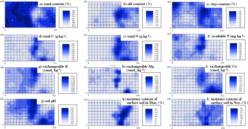
Figure 3. Spatial distribution of selected soil properties at the SJ site
Thus accumulation of fine particles of soils, which were eroded from further up of the slopes by herbaceous weeds and/or tree vegetation and organic matter/nutrient turnover under different vegetations (i.e. sugarcane and tree vegetation) were postulated to be the driving forces that could bring spatial heterogeneity of soil properties in these undulating sandy cropland.
SOM dynamics under different vegetation on sandy slope land in Ban Sam Jan, Khon Kaen Province
1. Materials and methods
Based on the distribution patterns of soil resources (Figure 3), five plots were selected for field studies associated with determining SOM dynamics (Figure 1). Plots 1, 2 and 3 were located in the sugarcane field, whereas Plots 4 and 5 were situated under mango and teak plantation, respectively. To estimate the amount of C input into the soils under tree vegetation, we measured litter input at Plots 4 and 5 during the period of 22 April 2004 to 21 April 2005 using litter traps in five replications. The C output from the soils was estimated by measuring in situ field soil respiration rate using a closed chamber method. Soil respiration rate was measured 16 times during the period from May 2003 to April 2004. The procedure basically followed the guidelines of Andersen (1982). Two series of PVP cylinders were prepared in each of five replications on the five plots. One series (15 cm in height and 14.4 cm in diameter) were inserted into the soils to a depth of 5 cm, and the others (height 30 cm and diameter 14.4 cm) was inserted to a depth of 15 cm, the bottom of which was later covered with fine mesh to support inner soils. For each measurement, the bottom of the latter cylinders was covered by a plastic sheet to prevent carbon dioxide (CO2) invasion from plant-root respiration. We assume that soil respiration in the former included both SOM decomposition and plant-root respiration, whereas that in the latter was assumed to practically exclude root respiration. The rate of soil respiration was calculated based on the increase of CO2 concentration 30 min after covering the tops of the cylinders. Both the initial and final CO2 concentration was measured using a portable infrared CO2 analyser (Anagas CD98; Environmental Instruments, Leamington Spa, UK). At the same time, soil temperature and volumetric moisture content were measured at each plot. Soil temperature and moisture were also continuously monitored by data-logger (CR10X; Campbell Co. Ltd., Logan, USA) at Plot 2.
2. Results and discussion
According to the data-logger’s monitoring (data not presented here), the surface soils once being wet started to immediately dry down after each rainfall event even in the mid-rainy season on the sandy soils. In the year 2003, the rainy season commenced in late May and finished at the end of September, with a relatively long drought in July. Soil temperature was mostly above 25°C during the rainy season.
The seasonal fluctuation of litter fall in the forested plots (Plots 4 and 5) is given in Figure 4. At both plots, higher amounts of litter fall were evident in the latter half of the dry season presumably due to a higher water stress. On the other hand, as shown in Figure 5, soil respiration was higher during the rainy season. In order to estimate total soil respiration throughout the year, we first established an equation that represented the relationship of the in situ hourly soil respiration rate and environmental factors (such as soil temperature and moisture) by multiple regression analysis. We then calculated hourly soil respiration rate by substituting each parameter of the equation using monitored data, and summed up the hourly soil respiration rates for a given period. In the first step, we assume the Arrhenius-type relationship between soil temperature and respiration rate, as follows:

where Cem is an hourly soil respiration rate with or without root respiration (mol C ha–1 h–1), θ is a volumetric soil moisture content (L L–1), E is the activation energy (J mol–1), R is the gas constant (8.31 J mol–1 K–1), T is an absolute soil temperature (K), and a and b are coefficients. The equation was then rewritten in the logarithm form:

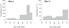
Figure 4. Seasonal fluctuation of litter fall in the mango plantation (Plot 4) and the teak stand (Plot 5) at the SJ from April 2004 to April 2005
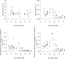
Figure 5. Soil temperature, moisture, and respiration rate measured at the experimental plots at the SJ O, Plot 1; A, Plot 2; V, Plot 3; A, Plot 4; •, Plot 5
Following this, a series of coefficients (a, b and E) are calculated by stepwise multiple regression analysis (p = 0.15) using the measured data, Cem, θ and T (SPSS Inc. 1998).
The results of regression analysis are summarized in Table 3. The coefficients relating to soil temperature (E) was usually rejected (p = 0.15) except for the cases in whole soil respiration in Plots 3, 4 and 5, indicating that under the tropical climate in the present study the effects of seasonal fluctuation of temperature on soil respiration rate were rather limited. In contrast, coefficient b usually caused a fluctuation of the soil respiration rate due to the presence of a distinct dry season. In the trial, however, the value of r2 was sometimes unexpectedly low. A possible short-term fluctuation of microbial biomass and/or its activity affected by temperature/moisture fluctuation in poorly covered surface soils may be one of the reasons for such low r2.
Using these regression equations and soil temperature and moisture data monitored in Plot 2, cumulative soil respiration during the year was calculated. As the monitored data was available for only one of the five plots, fluctuations in soil temperature and moisture for the remaining four plots were assumed based on the relationship between the actual data and the monitored data of Plot 2. The results of these calculations are given in Table 4. Annual soil respiration without root respiration was the highest in Plot 5, followed by Plot 4, and then by sugarcane plots (Plots 1, 2 and 3), ranging from 4.01 to 8.57 Mg C ha–1 y–1. The values from tree vegetation (Plots 4 and 5) were similar to those reported for tropical forests in Asia; for example, 8.5 Mg C ha–1 y–1 in peninsular Malaysia (Kira 1976) and 7.4 Mg ha–1 y–1 in Northeastern Thailand (Tulaphitak et al. 1985). Contrasting this, the annual soil respiration including plant root respiration ranged from 7.09 to 15.0 Mg C ha–1 y–1. The contribution of root respiration on whole-soil respiration was calculated to be between 37-56%, which was similar to the estimation (50%) by Nakane (1980).
Table 3. Parameters determined by stepwise analysis using the equation: Cem = eaθ be – E/RT and its logarithm form: InCem = a + blnθ – E/RT
|
n |
a |
b |
E (kJ mol–1) |
r 2 |
|
|
Excluding plant roots |
|||||
| Plot 1 | 16 | 5.90 *** | 1.36 *** | ---- | 0.43 *** |
| Plot 2 | 16 | 5.15 *** | 1.19 *** | ---- | 0.42 *** |
| Plot 3 | 16 | 7.05 *** | 1.81 *** | ---- | 0.45 *** |
| Plot 4 | 16 | 6.56 *** | 1.57 *** | ---- | 0.63 *** |
| Plot 5 | 15 | 5.02 *** | 1.09 ** | ---- | 0.34 ** |
|
Including plant roots |
|||||
| Plot 1 | 16 | 5.68 *** | 1.14 *** | ---- | 0.58 *** |
| Plot 2 | 16 | 6.59 *** | 1.41 *** | ---- | 0.74 *** |
| Plot 3 | 16 | 39.7 * | 2.10 *** | 78.4 * | 0.55 *** |
| Plot 4 | 16 | 42.6 ** | 1.36 *** | 89.6 * | 0.79 *** |
| Plot 5 | 16 | 32.4 * | 1.10 *** | 67.6 * | 0.71 *** |
| *, **, ***: Singnificant at 15%, 5%, and 1% levels, respectively. | |||||
Table 4 also summarizes the amounts of SOM stock (up to 15 cm depth) in the soil profiles. Total SOM stock, including litter layer, in the soil profiles ranges from 4.5 to 18.6 Mg C ha–1 y–1. Compared with the total stock, annual output of soil C via soil respiration is rather large (equivalent to 40-90% of SOM stock). This may be one of the unique features of sandy soils that would explain the lack of accumulation of high concentrations of SOM. Under field crops, the SOM stock would be exhausted within a few years after forest clearing. In contrast, as shown in Plot 4 (mango plantation), amount of litter fall was sometimes much higher than the annual soil respiration under tree vegetation, indicating that the SOM stocks were increasing quite rapidly. Even in the case of
Table 4. Fluxes and stocks of soil organic matter at each of the plot in SJ
|
Soil respiration |
Soil respiration |
Amount of litter-fall2 |
Organic matter in litter layers |
Soil organic |
|
|
(Mg C ha–1 y–1) |
(Mg C ha–1 y–1) |
(Mg C ha–1 y–1) |
(Mg C ha–1) |
(Mg C ha–1 ) |
|
| Plot 1 | 4.47 | 7.09 | n.d. | 0.16 |
5.63 |
| Plot 2 | 4.08 | 9.18 | n.d. | 0.18 |
6.08 |
| Plot 3 | 4.01 | 7.16 | n.d. | 0.17 |
4.28 |
| Plot 4 | 7.66 | 14.8 | 13.7 | 2.89 |
13.5 |
| Plot 5 | 8.57 | 15.0 | 4.55 | 1.01 |
17.6 |
|
1 Determined for May 1, 2003 to Apr. 30, 2004. |
|||||
Plot 5 (teak plantation), litter input was expected to be higher than the measured value since dead root-litter could not be counted in this experiment. Thus SOM stocks can be easily increased under tree vegetation on the sandy soils studied. The overall positive correlation observed between SOM stock in the upper layer and annual soil respiration (r = 0.99, n = 5) indicates that we could calculate SOM decomposition rate based on the present stock. It is possible to simulate the future SOM status if we know the amount of litter input from tree and/or crop vegetation.
Comparative analysis on conditions for surface runoff generation in different regions of Northern and Northeast Thailand
1. Materials and methods
One of most serious problems after forest clearing for agricultural production is soil erosion, which removes fertile surface soils within a short period. In fact our experimental field in Ban Sam Jan has been affected by soil erosion and as a result noticeable spatial heterogeneity of soil resources was observed. Several factors can affect the intensity of soil erosion; i.e. rainfall intensity, length of slopes, slope gradient, and surface coverage (Wischemeier and Smith 1978; Sonneveld and Nearing 2003). In the present study, we investigated conditions for surface runoff generation, which can be closely related to soil erosion, in three different agricultural slopes in Northern and Northeast Thailand with special reference to weather factors such as rainfall intensity and/or soil conditions.
Three experimental plots were installed. One is the sugarcane field of Ban Sam Jan (SJ) in 2002, which was the same plot as Plot 2 in the previous discussed study. Detailed information on soils and landscape were presented previously. The slope gradient was about 5%. The second plot was installed in Ban Nam Rin (NR), upper north of Mae Hong Son Province, at which marketed vegetables were cultivated at a moderately high elevation (800 m). The soils in this area were derived from limestone and, hence, not strongly acidic and suitable for annual crops. They were classified into Udic Haplustalfs according to US Soil Taxonomy (Soil Survey Staff 2003). The slope gradient of the NR plot was approximately 35% (20º). The soil surface was kept bare during our experiment (2002). The last plot was installed in Ban Du La Poe (DP), Mae Hong Son Province, where traditional shifting farmers of Karen people inhabit this mountainous regions (1,200 m above sea level). The soils were derived from fine-textured sedimentary rocks and classified as Ustic Haplohumults. The slope gradient of the DP plot was about 60% (30º). Upland rice was planted after reclamation of fallow forest (7 years) in our study year (2001).
At these plots, one 2.5 m × 2.5 m plot at the SJ site and a duplicate 1 m × 1 m plots both in NR and DP were installed, which were surrounded by stainless steel plates in upper border and both sides; so that no runoff water entered the plots from outside. A water budget for the small plots was calculated at 10 min intervals based on the measured values of rainfall (by a rain gauge), volumetric soil moisture contents in 0-15 and 15-45 cm layers of soil (by TDR probes) and amount of surface runoff (using a hand-made runoff gauge) on a data-logger (CR-10X; Campbell Co. Ltd.).
Soil physical and physicochemical properties were determined using undisturbed core samples and air-dried soil samples (<2 mm), respectively. The eroded soils trapped in the bucket just below the runoff gauge were collected after termination of the experiment and total amount of soil erosion throughout the rainy season was determined at each plot.
2. Results and discussion
Table 5 presents selected physical and physico-chemical properties of the soils studied. The soils of SJ were characterized by sandy texture, low SOM content, high bulk density and lower hydraulic conductivity with a low total porosity below 0.5 L L–1 compared to NR and DP. It should be noted that the moisture content at field capacity (-6 kPa or pF 1.8) was approximately 0.4 L L–1 in the clayey soils (NR and DP), whereas that was 0.25 L L–1 in the sandy soils in SJ.
Figure 6 shows daily rainfall and fluctuation of soil moisture contents in the study plots. It is of note that during a certain period data was not recorded due to a malfunction of the data-logger. Even in the rainy season, SJ experienced a clear drought from mid-June to July with little rainfall. Surface soil moisture fell to an equivalent level as observed in the dry season, i.e. around 0.05 L L–1. After mid-August, as regular rainfall events occurred, the moisture content in the subsoils was continuously maintained at field capacity or capillary saturation (θ = 0.25). At the NR site, capillary saturation occurred earlier, that is, in mid-June the moisture condition of the subsoils reached the level of field capacity (θ = 0.4) and, though data were missing during a certain period, such a situation was considered to be maintained until the end of rainy season. After September, the moisture condition of surface soils also reached the level of the field capacity. Contrasting this, the moisture conditions of both the surface and subsoils at the DP site reached capillary saturation immediately after the start of rainy season (i.e. mid-May) and such a situation lasted to the end of the rainy season.
Figure 7 describes the proportion of rainfall distribution observed for rainfall events with different 10 min rainfall intensities, i.e. 0-1, 1-2, 2-5, 5-10, and >10 mm per 10 minutes, respectively, monitored at each experimental plot over two consecutive years. SJ was characterized by a higher occurrence of more intensive rainfall than the others, e.g. rainfall with intensity of >10 mm per 10 minutes occurred more than 10% of total rainfall. In contrast, at the DP site that is situated in the highlands, low intensity rainfall events of <1 mm per 10 minutes were dominant and almost no rainfall events of >10 mm were observed. A noticeable feature of the rainfall distribution in DP was that intensive rainfall events were distributed more often in the latter half of the rainy season (Aug.–Oct.). The situation of NR was intermediate between the SJ and DP sites.
Table 5. Physical and physicochemical properties of the soils for the runoff-experiments in three different regions in Northern and Northeast Thailand
| Site | Depth | Bulk density | Solid phase | Total porosity |
Moisture content |
Saturated hydraulic conductivity |
Particle size distribution |
|||
| sand | silt | clay | ||||||||
| (cm) |
(g cm-3 ) |
(L L-1) |
(L L-1) |
(L L-1) |
(m s-1) |
(%) | (%) | (%) |
(g kg-1 ) |
|
| SJ | 0-7 | 1.41 | 0.52 | 0.48 | 0.25 |
1.2 ×10⁻⁵ |
88 | 5 | 3 |
2.71 |
| 7-15 | 1.56 | 0.57 | 0.43 | 0.26 |
6.4 × 10⁻⁶ |
89 | 6 | 5 |
1.22 |
|
| 15-30 | 1.72 | 0.64 | 0.36 | 0.25 |
7.5 × 10⁻⁶ |
86 | 6 | 7 |
0.24 |
|
| 30-45 | 1.80 | 0.68 | 0.32 | 0.24 |
1.1 × 10⁻⁶ |
80 | 5 | 12 |
0.53 |
|
| NR | 0-15 | 0.98 | 0.34 | 0.66 | 0.43 |
6.1 × 10⁻⁵ |
23 | 20 | 57 |
33.4 |
| 30-40 | 1.09 | 0.37 | 0.63 | 0.45 |
1.9 × 10⁻⁵ |
23 | 11 | 66 |
14.1 |
|
| DP | 0-15 | 0.83 | 0.29 | 0.71 | 0.44 |
5.8 × 10⁻⁵ |
40 | 13 | 47 |
43.5 |
| 30-40 | 1.23 | 0.45 | 0.55 | 0.39 |
2.5 × 10⁻⁵ |
36 | 13 | 51 |
19.7 |
|
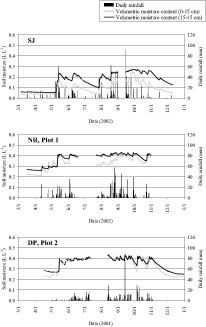
Figure 6. Fluctuation of soil moisture with daily precipitation at the SJ, NR and DP plots
In order to analyze water movement and runoff generation from each rainfall event under different soil conditions and/or rainfall intensity, soil moisture conditions and amounts of rainfall and surface runoff were monitored at 10 minutes interval. Figure 8 presents two representative cases of water movement at each rainfall event, i.e. the case of rainfall on a dry surface of sandy soil of SJ (a) and that on wet surface of a clayey soil at the NR site (b). In the upper figures, the amount of rainfall and fluctuation of soil moisture contents at 0-15 and 15-45 cm were shown together with surface runoff observed. The processed data are presented in the lower figures, that is, cumulative amounts of rainfall (RFc) and surface runoff (ROc) and total increase of soil moisture content in 0-45 cm depth (θc) since the start of the rainfall event. The cumulative water loss (WLc) was calculated as: WLc = RFc – θc – ROc.
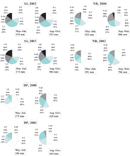
Figure 7. Proportion of the amounts of rainfall having different 10-min rainfall intensities in different seasons at the SJ, NR, and DP plots
Using these data, we can trace the fate of water associated with a rainfall event. For example, the rainfall event (a) started at 18:10 on May 9. Both the surface and subsoils were dry as θ was 0.04 and 0.05 L L–1, respectively. Even under such a condition, when an intensive rainfall (11.9 mm per 10 minutes) was observed at 19:40, water seemed to be stay on the soil surface judging from the fact that WLc tentatively increased sharply (and subsequently decreased) as shown in the lower figure, and surface runoff occurred though the amount was rather small as 0.2 L m–2 (only 1.7% of the amount of rainfall water) (in the upper figure). At this stage water percolated into the soils rather easily, as shown in the upper figure, that is, the moisture content of the surface soil increased rapidly and then decreased slowly; on the other hand, the subsoil moisture content increased slowly as water percolated from the overlying layer. Since WLc initially increased, it later declined to close to zero as puddle-water on the surface percolated into the soils, downward movement of water further down to 45 cm depth of soils, or internal drainage, was limited.
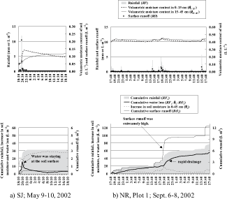
Figure 8. Examples of water dynamics on rainfall events under different conditions
a) Rainfall on dry surface of sandy soil of SJ
b) Rainfall on wet surface of clayey soil of NR
In the case of rainfall event (b), both the surface and subsoils were already wet (θ = 0.40 and 0.42 L L–1, respectively) at the start of rainfall at 17:40 on Sept. 6. During the following two days, total rainfall amounted to 77 mm with moderate intensities (5.6 mm per 10 minutes at the highest rate). Even so, very high surface runoff was observed when the rainfall intensity increased; e.g. 1.5 L m–2 with 4.9 mm of rainfall at 19:00, Sept. 7 and 1.6 L m–2 with 5.6 mm of rainfall at 15:30, Sept. 8, respectively. In these cases, water loss through surface runoff accounted for 31 and 29% of the total incoming rainfall, respectively. Rainfall water could not percolate immediately into the soil layers with high moisture content. But even after such a rainfall event accompanying the catastrophic surface runoff, moderately rapid increases in WLc were observed (in lower figure), suggesting a rapid drainage from soil layers.
As analyzed for these rainfall events, both the rainfall intensity and soil moisture condition on each rainfall event seemed to affect the surface runoff generation. To analyze factors controlling runoff generation in each plot in more detail, stepwise multiple regression analysis was conducted using dataset of the amounts of rainfall (RF), surface runoff (RO), soil moisture contents in the 0-15 and 15-45 cm layers of soil (θ0–15 and θ15–45, respectively) and water loss (WL). The dataset were composed of data collected from the start of the respective rainfall to 24-hours after the termination of the rainfall, and were sampled for rainfall events that had a cumulative rainfall of greater than 10 mm for each event. A total of 24, 20 and 19 rainfall events met these conditions in the SJ, NR and DP plots, respectively, during one rainy season. In NR and DP plots, data from the two plots were incorporated into a single analysis. The model functions in the stepwise multiple regression were as follows:
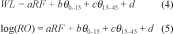
where WL = RF – ∆SM – RO and ∆SM is the increment in soil moisture content in the 0-45 cm layers for the time intervals. In the first equation above for determining WL, datasets with a 10-min interval were converted to a 4-hr interval to eliminate the influence of water puddles on the soil surface. WL was considered to be mainly composed of drainage and evapotranspiration and partially of direct evaporation from puddles on the soil and/or plant leaf surfaces after rainfall. On the other hand, in the second equation for RO, original dataset with a 10-min interval was used. A logarithm transformation of the RO data was undertaken with the value of zero omitted from the dataset.
The result of the regression analysis is given in Table 6. In all the cases both for the WL and RO, rainfall intensity was firstly selected as an independent (or explanatory) variable. An overall positive contribution of θ0–15 (SJ) or θ15–45 (NR and DP) to WL indicated generally well-drained characteristics of the soil studied (shown in upper column in Table 6); that is, moist condition did not interfere with the internal drainage, or when soil was dry rainfall water was firstly used to fill capillary porosity and did not drain directly through bypass flow. Although the soils were generally well-drained, the moisture content in the surface layer significantly affected the surface runoff generation (log(RO)), indicating that RO tended to increase when soil was wet due to interference of rapid percolation of rainfall water into soils. According to the equation obtained in Table 6 and the 10-minutes intervals’ data monitored by the data-logger, the surface runoff generation was simulated and is presented in Figure 9. In general the equation obtained above simulated well the actual surface runoff measured. Based on the parameters of the regression equation and seasonal distribution pattern of surface runoff observed, we can assume the risk of surface runoff generation at each plot as well as its possible reasons as follows.
In SJ, in spite of its much lower slope gradient (i.e. 5%) compared to the other two (35% in NR and 60% in DP), noticeable and frequent surface runoff occurred with no clear seasonal trend, possibly with rainfall events with high intensities. It seems to be, therefore, difficult to decrease the high erosion risk using some time-course land management such as controlled seedling time of crops, etc. Spatial land management, i.e. incorporation of tree vegetation in some areas, would be a feasible option to decrease the overall risk of soil loss from agricultural land through erosion. On the other hand, it seemed that the surface runoff occurred more frequently in the later half of the rainy season on steeper slopes at the NR and DP sites due to more frequent capillary saturation at the NR or more distribution of heavier rainfall at the DP in that period. It would therefore be possible to decrease the probability of soil erosion through appropriate land management, e.g. selection of crops that do not result in the land being left bare during the later half of rainy season.
Table 6. Parameters for simulating water loss (WL) from the soil profiles and surface runoff (LO) using the rainfall intensity (RF) and initial soil moisture contents (θ0–15 and θ15–45) determined by stepwise multiple regression analsis:
| a | b | c | d | r 2 | n | |
| Water loss (WL ; 4-hr interval) | ||||||
|
SJ |
0.374 *** | 9.87 *** |
----- |
-0.409 | 0.70 *** |
194 |
|
NR |
0.389 *** | ----- | 16.1 *** | -5.27 *** | 0.56 *** |
639 |
|
DP |
0.532 *** | -10.8 * | 82.4 *** | -27.6 *** | 0.57 *** |
406 |
|
Surface runoff (log(RO ); 10-min interval) |
||||||
|
SJ |
0.145 *** | 2.52 *** | -0.921 ** | -1.95 *** | 0.79 *** |
182 |
|
NR |
0.184 *** | 3.14 *** |
----- |
-2.44 *** | 0.59 *** |
364 |
|
DP |
0.194 *** | 0.968 *** |
----- |
-1.64 *** | 0.60 *** |
453 |
|
*, **, ***: Singnificant at 15%, 5%, and 1% levels, respectivel |
||||||
Table 7 summarizes total amounts of rainfall, surface runoff, and soil erosion in the same units (kg m–2). The proportion of surface runoff generated against the unit amount of rainfall (b/a × 100 (%) in the table) increased in the order of SJ < NR < DP. It was consistent with the order of slope gradient of the plots. The proportion of the amount of soil erosion on the unit surface runoff (c/b × 100 (%) in the table), however, decreased in the same order, indicating that the sandy soils in SJ were more easily eroded than the clayey soils presumably due to weakly organized structure of soil aggregates. The sandy soils in SJ seemed to be quite susceptible to soil erosion.
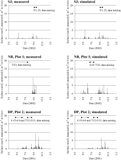
Figure 9. Measured and simulated values of surface runoff at selected plots of SJ, NR and DP
Table 7. Total amounts of rainfall, surface runoff, and soil erosion during the experiment
| Site | Total amount |
Amount of surface runoff generated (b ) |
Amount of |
Proportion |
Proportion |
|
|
(kg m–2) |
(kg m–2) |
(kg m–2) |
(%) |
(%) |
||
| SJ | 963 | 23.8 | 0.76 |
2.47 |
3.21 |
2002/3/6-12/31 |
| NR | 989 | 42.1 | 0.10 |
4.26 |
0.24 |
2002/3/17-11/1 |
| DP | 558 | 49.5 | 0.045 |
8.86 |
0.091 |
2001/4/18-12/31 |
|
* Amount of rainfall was converted to the area basis on slope. |
||||||
Conclusion
Spatial heterogeneity of soil properties was clearly observed on the gentle slope of sandy soils in SJ, Northeast Thailand. SOM dynamics and surface erosion were postulated to be primary factors that resulted in the spatial distribution patterns of soil properties. Both processes were rather intensive on the tropical sandy soils and seemed to be difficult to be controlled. It is, therefore, suggested that adaptation of agricultural systems to the unique condition through spatial or site-specific land management may be an effective means of reducing negative impacts. This could include the incorporation of tree species in mosaic distribution, rather than to eliminate or decrease the risks of SOM decomposition or soil erosion.
References
Andersen, J.P.E. 1982. Soil Respiration. In: Page, A.L., Miller, R.H. and Keeney, D.R., eds., Methods of Soil Analysis. Part 2. Chemical and Microbiological Properties. 2nd Edition. Madison, Wisconsin, USA, 831-871.
Goerres, J.H; Dichiaro, M.J; Lyons, J.B; Amador, J.A. 1997. Spatial and temporal patterns of soil biological activity in a forest and an old field. Soil Biology and Biochemistry, 30: 219-230.
Burgess, T.M.; Webster, R. 1980. Optimal interpolation and isarithmaic mapping of soil properties. II. Block kriging. Journal of Soil Science, 31: 333-341.
Kira, T. 1976. Terrestrial ecosystem. Kyoritsu, Tokyo, 146-147 (in Japanese).
Nakane, K. 1980. Comparative studies of cycling of soil organic carbon in three primeval moist forests. Japanese Journal of Ecology, 30: 155-172 (in Japanese with English summary).
Tulaphitak, T.; Pairintra, C.; Kyuma, K. 1985. Changes in soil fertility and tilth under shifting cultivation, III. Soil respiration and soil tilth. Soil Science and Plant Nutrition, 31: 251-261.
Robertson, G.P. 1998. GS+: Geostatistics for the Environmental Sciences. Gamma Design Software, Plainwell, Michigan, USA.
Royal Forest Department 1998. Forestry Statistics of Thailand. Ministry of Agriculture and Cooperatives, Bangkok. http://www.forest.go.th/stat41/content_e. htm
Soil Survey Staff 2003. Keys to Soil Taxonomy. Ninth Edition. US Department of Agriculture and National Resources Conservation Service, Washington.
Sonneveld, B.G.J.S.; Nearing M.A. 2003. A nonparametric/ parametric analysis of the Universal Soil Loss Equation. Catena, 52: 9-21.
SPSS 1998. SYSTAT 8.0. Statistics. SPSS Inc., Chicago, Illinois, 1086 p.
Wischemeier, W.H.; Smith, D.D. 1978. Predicting rainfall erosion losses. Agricultural Handbook 537. USDA, Washington, DC.
1 Graduate
School of Agriculture, Kyoto University,
Kyoto, 606-8502 Japan, [email protected].
2 Graduate School of Agriculture, Kyoto
Prefectural
University, Kyoto, 606-8522 Japan.
3 Faculty of Agriculture, Khon
Kaen University,
Khon
Kaen, 40002 Thailand.
![]()
![]()
![]()