![]()
![]()
![]()
Hartemink, A.E.1, and J. Huting
Keywords: SOTER, Arenosols, Africa, extent sandy soils, soil properties
|
Abstract Sandy soils cover about 13% in sub-Saharan Africa and are widely spread in the Southern and Eastern parts of Africa. Although they occur in sparsely populated regions, many of these soils are under stress; they are brought into cultivation or are used for extensive grazing. This paper reviews the importance of sandy soils in 9 countries of Southern and Eastern Africa (Angola, Botswana, Kenya, Mozambique, Namibia, Tanzania, South Africa, Swaziland and Zimbabwe). Estimates of their extent are based on SOTER databases. The total extent of sandy soils in the 9 countries is about 176 million ha. Sandy soils occur extensively in Angola and Botswana (>50% of total land area) but also in Zimbabwe, South Africa and Mozambique (>15% of total land area). The SOTER Arenosol map was matched with the recent land-cover map of Africa to calculate the extent of Arenosols under agriculture. About 7 million ha of Arenosols are under cropland, most of which is located in Angola, Botswana and South Africa. From the SOTER databases, soil chemical properties were summarised. The average Arenosol topsoils in Namibia and South Africa are alkaline with a soil reaction over 7. In Angola, Zimbabwe and Tanzania the average topsoil pH of Arenosols is below 6. Organic carbon (C) is uniformly low in Arenosols of Southern and Eastern Africa and rarely exceeds 10 g kg–1. Higher C contents are generally found in soils with higher clay content, whereas higher C contents are also associated with higher cation exchange capacities (CECs). Management of these soils is problematic, the low CEC and water holding capacity necessitates addition of organic manures, but quantities available are minimal and organic matter decomposes rapidly. Conservation practices result in major yield penalties even when large amounts of nutrients are added and the capacity of the soils to stabilize organic matter is limited by the very low clay and silt contents. Most appropriate management involves use of frequent but small doses of inorganic fertilizers. |
Introduction
Sandy soils occur in all parts of the world. When these soils have greater than 70% sand and less than 15% clay, they are classified as Arenosols in the World Reference Base (FAO, 2001) and in Soil Taxonomy as sandy Entisols: Psamments when well-drained, or as Psammaquents when in tidal marshes, deltas and wetlands (Soil Survey Staff, 1999). In the World Reference Base, sandy soils may also occur in the reference groups Regosols, Leptosols and Fluvisols. Arenosols may have developed in residual sands, in the weathering products of quartz-rich rock or in recently deposited sands common to deserts and beaches (FAO, 2001).
Arenosols are particularly widespread in Africa where about 51% of the Arenosols of the world are found. About 21% of the Arenosols are found in Australasia whereas 10% of the Arenosols occur in South and Southeast Asia. Less than 14% of the global extent of Arenosols is found in South and Central America and only small patches are found in North America and Europe. Worldwide Arenosols cover approximately 9 million km2 (900 million ha), compared to about 300 million ha of Vertisols and 700 million ha of Ferralsols. Yet, Arenosols have not received the same amount of research attention – possibly as many of the Arenosols are not used for agriculture or only in a very extensive way (i.e. for grazing or fuel wood collection).
Most Arenosols are or were located in arid or semiarid regions (van Wambeke, 1992). Arenosols are only weakly developed with little soil horizon formation. In general chemical weathering is often slow in these soils because of the prevalent hot and dry conditions under which they are formed in the arid and semi-arid tropics. Physical weathering is dominant resulting from extreme changes in diurnal temperatures and seasons. Wind erosion may be a problem in many areas dominated by Arenosols because of the lack of soil cover and weak soil structure (FAO, 2001). Characteristic properties of Arenosols are high water permeability, low water-holding capacity, low specific heat, and often minimal nutrient contents. In summary: Arenosols have a large number of unfavourable attributes for sustainable agriculture (van Wambeke, 1992). They are best kept covered by vegetation. Also under natural conditions it is difficult to establish dense plant communities on Arenosols due to the exploitation for firewood, grazing or the destructive effects on the tree layer by large vertebrates and periodic burning (Almendros et al., 2003). In many parts of Southern and Eastern Africa, Arenosols are increasingly used for arable farming because of pressure on the land forcing the cultivation of such unfavourable soils. Extensive rainfed production of annual crops is possible and groundnuts and cassava are often considered best adapted to Arenosols but also tobacco is grown on Arenosols. Perennial crops on Arenosols include cashew, coconuts, citrus, eucalyptus and pinus (van Wambeke, 1992).
In Africa, Arenosols cover about 273 million ha or almost 13% of the total land mass (Eswaran et al., 1997). They occur widely in the western part of the continent where much soil fertility research on sandy soils takes place (e.g. Mokwunye, 1991; Pieri, 1989; Sanginga et al., 1995; Vanlauwe et al., 2002). This work has greatly contributed to the sustainable management of Arenosols which – in essence – suffer from both poor soil chemical and physical properties. Relatively little work has been conducted on Arenosols in the southern and eastern part of the continent possibly as the extent of Arenosols is smaller, and their importance lower.
This paper focuses on Arenosols in Southern and Eastern Africa. The extent and properties are summarised. The objectives of this paper are to estimate the extent and properties of sandy soils in Southern and Eastern Africa based on SOTER databases, followed by a brief discussion on soil management strategies for sustainable crop production.
Databases and experimental data
Soil databases
Since the mid 1980s, a global soil and terrain database has been developed at a scale of 1:1 million. The scale independent database, named SOTER (Global SOils and TERrain Digital Database), holds information of a maximum of 118 soil and terrain attributes (Oldeman and van Engelen, 1993). SOTER is to replace the 1:5 million FAO-Unesco soil map of the world (van Engelen and Hartemink, 2000). Continental scale SOTER databases are available for Latin America and the Caribbean, Central and Eastern Europe and Southern Africa. The SOTER methodology has been applied at scales ranging from 1:250,000 to 1:5 M (Batjes, 2004) and a range of single value maps or data and interpretative products can be extracted. SOTER has been used in studies on vulnerability assessment to pollution mapping in Central and Eastern Europe, the impact of erosion on crop productivity in various tropical countries, global environmental change studies and agro-ecological zoning (Batjes, 2002; Batjes, 2004). SOTER databases can also be combined with remote sense imagery to investigate links between land use and soils.
SOTER consists of units that contain a distinctive, often repetitive, pattern of landform, lithology, surface form, slope, parent material and soil. SOTER puts emphasis on the relationships between landform, parent material and soils, integrating these into one unit: the SOTER unit. Each SOTER unit represents a unique combination of terrain and soil characteristics and a maximum of 118 attributes. As SOTER units consist of a combination of a terrain and soil component, they may contain several soil components. For example, a SOTER unit may consist of 60% Ferralsols, 20% Vertisols and 20% Acrisols, or a unit may have 80% Vertisols and 20% Fluvisols.
Southern Africa
The 1:5 M soil map of Africa was published in 1973. Early 2000, FAO and ISRIC – World Soil Information started to compile a SOTER database for Southern Africa. It included the compilation and harmonisation of a soil and terrain digital database for 8 countries in Southern Africa: Angola, Botswana, Mozambique, Namibia, South Africa, Swaziland, Tanzania and Zimbabwe (Dijkshoorn, 2003; FAO-ISRIC, 2003). The database was compiled from national SOTER databases combined with available soil maps and soil and terrain data including digital elevation models. The database has a generalised scale of 1:2 M but the detail and quality or information varies widely between and within countries (Dijkshoorn, 2003). For example, in South Africa SOTER units are based on a scale of 1:250,000 whereas in several other countries soils have been mapped at 1:1 M or smaller. SOTER units in Southern Africa are comprised of up to 7 soil components, with an average of 2. In total there are 941 soil profiles in the SOTER databases of Southern Africa, whereas the SOTER database for Kenya contains 366 soil profiles. Of these 1,307 soil profiles 165 are Arenosols (Table 1). From the databases, SOTER units were selected in which Arenosols were dominant and their extent exceeded 75%. These queries were made with ArcView 3.3. Successively, the total extent of Arenosols was calculated for each country and a map was produced showing the distribution of Arenosols in the 9 countries.
Table 1. SOTER units and soil profiles for the 9 countries in Southern Africa, based on the SOTER database for Southern Africa and Kenya
|
SOTER |
Terrain |
Soil |
Number |
Number of Arenosols |
|
|
Angola |
238 | 322 | 887 |
150 |
60 |
|
Botswana |
94 | 145 | 404 |
60 |
6 |
|
Kenya |
39 | ? | ? |
366 |
11 |
|
Mozambique |
225 | 325 | 641 |
127 |
30 |
|
Namibia |
92 | 118 | 269 |
52 |
3 |
|
Tanzania |
169 | 297 | 687 |
54 |
4 |
|
South Africa |
3,039 | 7,006 | 11,822 |
328 |
39 |
|
Swaziland |
19 | 32 | 72 |
14 |
? |
|
Zimbabwe |
143 | 200 | 294 |
156 |
12 |
| Total | 4,019 | 8,445 | 15,076 |
1,307 |
165 |
Land cover map
The land cover map of Africa has been used to identify land cover classes in Southern and Eastern Africa (Mayaux et al., 2003). The map (grid map, spatial resolution 1 km) shows the major vegetation formations of the continent with an improved thematic content over previous land cover maps. The majority of the data were acquired in 2000. The map identifies 24 land cover classes, but for this paper, we reduced the number of land cover classes to 5 (forest, grass and shrub land, crop land, stony desert, salt hard pans) by combining several individual classes. From this land cover map, the total area of cropland was calculated for each of the 9 countries. The SOTER Arenosol map was the matched with the land cover map (Mayaux et al., 2003). For each of the Arenosol polygons, zonal statistics of the grid were used to calculate the extent of Arenosols for the 5 land cover classes. These were summed up per country to arrive at the area under agriculture.
Extent and land-cover of sandy soils
Arenosols occupy large areas from Central and East Angola and Namibia to Zimbabwe and Botswana (Figure 1). The Arenosols in large areas of Botswana and in surrounding countries are derived from the Kalahari sands. In Zambia and the western part of Angola many soils are buried under the Kalahari sands (Eswaran et al., 1997). In Zimbabwe the Arenosols have been mostly derived from the weathering of the underlying granitic rocks that contain large amounts of quartz (Burt et al., 2001). In Eastern Africa, Arenosols are mainly found along the coast and although Arenosols occur in Tanzania they are not shown since they are not dominant (<75%) in the SOTER units.
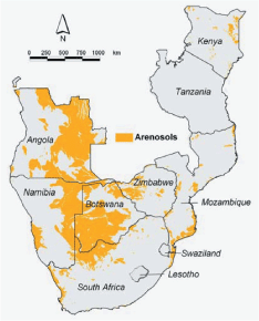
Figure 1. Distribution of Arenosols in Eastern and Southern Africa. Map shows the SOTER units in which Arenosols are dominant (>75% of the SOTER unit)
Total area of Arenosols in the 9 countries is estimated to be 176 million ha. The largest extent is found in Angola (63 million ha) where Arenosols cover about 51% of the total land area. In Botswana, Arenosols occupy 38 million ha or almost two-third of the whole country. Arenosols are also widespread in Namibia where they cover 26 million ha or 31% of the total land mass. Arenosols are also important in Mozambique, South Africa and Zimbabwe where they occupy million of hectares.
Of the total 176 million ha of Arenosols in Southern and Eastern Africa, about 7 million hectare are under cropland (Table 2). The largest extent is found in the south central part of Angola where about 2 million ha of Arenosols are cultivated. Considerable areas of Arenosols in Zimbabwe and South Africa are also under cropland (Figure 2). From the land cover map it was calculated that most of the Arenosols in the Southern and Eastern of Africa are under grassland – with or without shrubs (85 million ha) and various types of forest and woody vegetation (49 million ha).
Table 2. Extent of Arenosols, total area under cropland and total area Arenosols under cropland in 9 countries in Southern and Eastern Africa
|
Land |
Arenosols |
Total area Arenosols |
||||
|
million |
% |
million |
% of |
% of total area under cropland |
||
|
Angola |
125 | 64 | 51 | 1.9 |
2 |
39 |
|
Botswana |
58 | 38 | 66 | 1.1 |
2 |
23 |
|
Kenya |
59 | 3 | 6 | 0.1 |
<0.5 |
3 |
|
Mozambique |
79 | 17 | 21 | 0.4 |
<0.5 |
5 |
|
Namibia |
83 | 26 | 31 | 0 |
<0.5 |
1 |
|
Tanzania |
95 | 4 | 4 | 0 |
0 |
0 |
|
South Africa |
125 | 18 | 15 | 2.6 |
2 |
10 |
|
Swaziland |
2 | 0 | 0 | 0 |
<0.5 |
0 |
|
Zimbabwe |
39 | 6 | 16 | 0.9 |
2 |
8 |
| Total | 665 | 176 | 7.0 | |||
Properties of sandy soils
A summary of some key soil physical and chemical properties is given in Tables 3 and 4. The average sand content is highest in the topsoils of Arenosols in Angola, Zimbabwe, Namibia and Botswana (>92%) and lowest in the Arenosols of Kenya, Mozambique and Tanzania (<90%). Although this may appear an insignificant difference, the lower sand content (and thus higher silt and clay content) influences important characteristics such as water holding capacity and nutrient retention (Figure 3). Few bulk density data were available and most of the Arenosols have fairly high bulk densities, which is common for sandy soils.
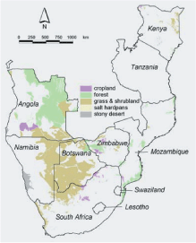
Figure 2. Simplified land-cover map of Arenosols in Eastern and Southern Africa, based on SOTER and land cover map of Mayaux et al. (2003)
The average Arenosol topsoils in Namibia and South Africa are alkaline with a soil reaction over 7. These soils have also base saturations of almost 100%.
Table 3. Summary of soil physical properties of Arenosols in Southern and Eastern Africa (mean ±1 SD). Number of profiles on which this summary is presented in parentheses
|
m |
Angola |
Botswana |
Kenya |
Mozambique |
Namibia |
Tanzania |
South Africa |
Zimbabwe |
||||||||
|
(60) |
(6) |
(11) |
(30) |
(3) |
(4) |
(39) |
(12) |
|||||||||
| Sand | 0-0.10 | 93 |
+3 |
94 |
+2 |
87 | ±7 | 89 |
+7 |
94 |
+2 |
88 |
+5 |
91 |
+8 |
93 ±4 |
| (%) | 0.10-0.20 | 93 |
+3 |
94 |
+2 |
80 | ±27 | 89 |
+7 |
94 |
+2 |
88 |
+5 |
91 |
+8 |
92 ±5 |
| 0.20-0.30 | 93 |
+3 |
92 |
+2 |
86 | ±6 | 90 |
+5 |
93 |
+2 |
88 |
+4 |
90 |
+9 |
93 ±4 | |
| Clay | 0-0.10 | 5 |
+2 |
3 |
+2 |
6 | ±3 | 6 |
+3 |
3 |
+1 |
6 |
+2 |
5 |
+4 |
4 ±2 |
| (%) | 0.10-0.20 | 5 |
+2 |
3 |
+2 |
6 | ±3 | 6 |
+3 |
3 |
+1 |
7 |
+2 |
5 |
+3 |
4 ±2 |
| 0.20-0.30 | 6 |
+3 |
4 |
+3 |
6 | ±4 | 6 |
+3 |
4 |
+1 |
6 |
+2 |
5 |
+4 |
5 ±3 | |
| Bulk | ||||||||||||||||
| Density | 0-0.10 | n.d. | 1.65 | ±0.11 | 1.41 | ±0.30 | 1.47 | ±0.10 | n.d. | n.d. | n.d. | n.d. | ||||
|
(kg m-3) |
0.10-0.20 | n.d. | 1.65 | ±0.11 | 1.41 | ±0.30 | 1.47 | ±0.10 | n.d. | n.d. | n.d. | n.d. | ||||
| 0.20-0.30 | n.d. | 1.67 | ±0.09 | 1.42 | ±0.20 | 1.45 | ±0.07 | n.d. | n.d. | n.d. | n.d. | |||||
| n.d. = no data | ||||||||||||||||
Table 4. Summary of soil physical properties of Arenosols in Southern and Eastern Africa (mean ±1 SD). Number of profiles on which this summary is based in parentheses
|
m |
Angola |
Botswana |
Kenya |
Mozambique |
Namibia |
Tanzania |
South Africa |
Zimbabwe |
|||||||||
|
(60) |
(6) |
(11) |
(30) |
(3) |
(4) |
(39) |
(12) |
||||||||||
| pH water | 0-0.10 | 5.8 |
±0.7 |
6.6 | ±1.5 |
6.9 |
±1.3 |
6.0 |
±0.6 |
7.9 |
±0.4 |
5.4 |
±0.5 |
7.1 |
±1.1 |
5.2 |
|
| (1:2.5) | 0.10-0.20 | 5.7 |
±0.8 |
6.6 | ±1.5 |
6.3 |
±2.5 |
5.9 |
±0.5 |
7.9 |
±0.3 |
5.4 |
±0.4 |
7.1 |
±1.2 |
5.2 |
|
| 0.20-0.30 | 5.7 | ±0.8 | 6.6 | ±1.6 |
6.8 |
±1.5 |
6.0 |
±0.5 |
7.5 |
±0.6 |
5.3 |
±0.3 |
6.8 |
±1.8 |
4.8 |
||
| Organic C | 0-0.10 | 6.2 |
±4.2 |
2.9 | ±1.1 |
3.10 |
±2.29 |
7.0 |
±4.1 |
2.6 |
±0.7 |
9.23 |
±8.78 |
3.32 |
±4.60 |
3.58 |
±0.36 |
|
(g kg-1) |
0.10-0.20 | 4.4 |
±4.0 |
2.8 | ±0.9 |
2.13 |
±2.37 |
5.9 |
±4.2 |
2.5 |
±0.7 |
8.88 |
±7.62 |
3.13 |
±4.72 |
2.21 |
±0.52 |
| 0.20-0.30 | 3.1 |
±2.4 |
2.2 | ±1.0 |
1.17 |
±1.47 |
4.1 |
±3.2 |
1.7 |
±0.6 |
8.11 |
±7.97 |
2.87 |
±4.75 |
3.16 |
±0.77 | |
| Total N | 0-0.10 | 0.44 |
±0.28 |
n.d. |
0.21 |
±0.27 |
0.67 |
±0.48 |
0.25 |
±0.01 |
0.60 |
±0.28 |
n.d. |
n.d. |
|||
|
(g kg-1) |
0.10-0.20 | 0.33 | ±0.26 | n.d. |
0.15 |
±0.23 |
0.51 |
±0.27 |
0.22 |
±0.04 |
0.60 |
±0.28 |
n.d. |
n.d. |
|||
| 0.20-0.30 | 0.24 | ±0.18 | n.d. |
0.05 |
±0.11 |
0.36 |
±0.20 |
0.08 |
±0.11 |
0.50 |
±0.14 |
n.d. |
n.d. |
||||
| CEC | 0-0.10 | 3.4 | ±1.5 | 3.3 | ±2.0 |
3.8 |
±2.4 |
4.1 |
±2.9 |
1.5 |
±1.3 |
5.7 |
±6.2 |
3.0 |
±2.0 |
1.7 |
±0.8 |
|
(cmol kg-1) |
0.10-0.20 | 2.9 | ±1.3 | 3.2 | ±2.0 |
3.6 |
±2.6 |
3.8 |
±3.1 |
1.5 |
±1.4 |
5.2 |
±6.6 |
3.0 |
±2.1 |
1.5 |
±0.7 |
| 0.20-0.30 | 2.5 | ±1.2 | 3.1 | ±1.9 |
3.3 |
±2.7 |
3.8 |
±3.1 |
1.6 |
±1.9 |
5.0 |
±6.7 |
2.9 |
±2.0 |
1.4 |
±1.0 |
|
| Base | 0-0.10 | 40 | ±30 | 80 | ±19 |
91 |
±49 |
86 |
±71 |
100 |
0 |
25 |
±15 |
80 |
±27 |
80 |
±22 |
| saturation | 0.10-0.20 | 35 | ±31 | 79 | ±19 |
84 |
±45 |
77 |
±80 |
100 |
0 |
17 |
±16 |
80 |
±27 |
80 |
±24 |
| (%) | 0.20-0.30 | 32 | ±31 | 75 | ±25 |
92 |
±41 |
68 |
±81 |
100 |
0 |
14 |
±14 |
96 |
±48 |
100 |
±15 |
| ESP | 0-0.10 | 1 | ±1 | 1 | ±2 |
6 |
±9 |
2 |
±4 |
3 |
±1 |
2 |
±2 |
5 |
±7 |
5 |
±8 |
| (%) | 0.10-0.20 | 2 | ±1 | 2 | ±2 |
6 |
±9 |
2 |
±4 |
2 |
±1 |
3 |
±4 |
5 |
±6 |
5 |
±8 |
| 0.20-0.30 | 2 | ±1 | 2 | ±3 |
10 |
±11 |
3 |
±3 |
2 |
±0.2 |
3 |
±4 |
5 |
±8 |
3 |
±4 |
|
| n.d. = no data | |||||||||||||||||
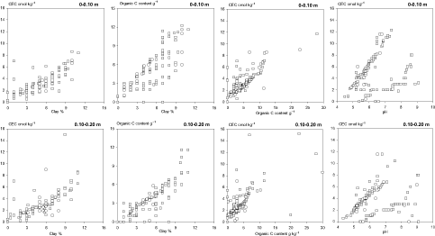
Figure 3. Relationships between clay content, CEC, organic C and pH in the topsoils (0-0.10 m and 0.10-0.20 m) of 166 Arenosols in Southern and Eastern Africa
In Angola, Zimbabwe and Tanzania the average topsoil pH of Arenosols is below 6 whereas in the other countries Arenosols have mostly a topsoil pH between 6 and 7. Organic C is uniformly low in Arenosols of Southern and Eastern Africa and rarely exceeds 10 g kg–1. Higher C contents are generally found in the soils with higher clay content (Figure 3). Clay content in the 0-0.10 and 0.10-0.20 m soil horizons correlated well (r2 >0.6) with both the CEC and the organic C contents. Higher organic C levels also increased the CEC whereas soil acidity seems to decrease the CEC in these Arenosols. The total N content of Arenosols in Southern and Eastern Africa is low and typically below 0.7 g kg–1. The cation exchange capacity ranges from about 1.3 cmol kg–1 in the Arenosols of Namibia to on average over 5.7 cmol kg–1 in Tanzania.
Summary and conclusions
In this paper the spatial distribution of sandy soils in Southern and Eastern Africa were presented together with a summary of their main soil physical and chemical properties. Although the coverage of soil profiles is uneven across the 9 countries it was shown that the extent of Arenosols in Eastern and Southern Africa is considerable and higher than 170 million ha. The real extent is possibly larger as soils with high sandy content also occur in the reference groups Regols, Leptosols and Fluvisols. Also, we have selected only those SOTER units in which Arenosols were dominant and exceeded 75%. This implies that some units were ommitted that contained less than 75% Arenosols but also that in some SOTER units the extent of Arenosols was less than 100%.
More than 7 million ha are under cropland and obviously it requires careful management to maintain and increase crop production on such sandy soils. There has been considereable research efforts on the sustainable management of sandy soils in West Africa and in the introduction of the paper we have listed some key references. Research efforts in Southern and Eastern Africa have been less and exchange of experiences and research results may be beneficial for farmers in both regions.
References
Almendros, G. et al., 2003. Biogeochemical assessment of resilient humus formations from virgin and cultivated Northern Botswana soils. Journal of Agricultural & Food Chemistry, 51(15): 4321-4330.
Batjes, N.H., 2002. Revised soil parameter estimates for the soil types of the world. Soil Use & Management, 18(3): 232-235.
Batjes, N.H., 2004. SOTER-based soil parameter estimates for Southern Africa (Version 1.0). Report 2004/04. ISRIC - World Soil Information, Wageningen.
Burt, R., Wilson, M.A., Kanyanda, C.W, Spurway, J.K.R. and Metzler, J.D., 2001. Properties and effects of management on selected granitic soils in Zimbabwe. Geoderma, 101(3-4): 119-141.
Dijkshoorn, J., 2003. SOTER database for Southern Africa (SOTERSAF). Technical report. ISRIC, Wageningen.
Eswaran, H., Almaraz, R., Vandenberg, E. and Reich, P., 1997. An Assessment of the Soil Resources of Africa in Relation to Productivity. Geoderma, 77(1): 1-18.
FAO-ISRIC, 2003. Soil and terrain database for Southern Africa (1:2 million scale). FAO Land and Water Digital Series 25 (CD ROM), FAO, Rome.
FAO, 2001. Lecture notes on the major soils of the world. World Soil Resources Reports 94. FAO, Rome.
Mayaux, P. et al., 2003. EUR 20665 EN - A land-cover map of Africa. Office for official publications of the European Communities, Luxembourg.
Mokwunye, A.U., 1991. Alleviating soil fertility constraints to increased crop production in West Africa. Developments in plant and soil sciences. Kluwer Academic, Dordrecht, vii, 244 pp.
Oldeman, L.R. and van Engelen, V.W.P, 1993. A world soils and terrain digital database (SOTER) - an improved assessment of land resources. Geoderma, 60(1-4): 309-325.
Pieri, C, 1989. Fertilité des terres de savanes. Ministère de la Cooperation et CIRAD-IRAT, Paris.
Sanginga, N., Vanlauwe, B. and Danso, S.K.A., 1995. Management of biological N2 fixation in alley cropping systems: Estimation and contribution to N balance. Plant & Soil, 174(1-2): 119-141.
Soil Survey Staff, 1999. Soil Taxonomy, 2nd edition. Agriculture Handbook Number 436. USDA National Resources Conservation Services, Washington DC.
van Engelen, V. and Hartemink, A.E., 2000. The global soils and terrain database (SOTER). ACLEP Newsletter, 9: 22-27.
van Wambeke, A., 1992. Soils of the tropics - Properties and appraisal. McGraw Hill, Inc., New York.
Vanlauwe, B., Diels, J., Sanginga, N. and Merckx, R. (Editors), 2002. Integrated plant nutrient management in sub-Saharan Africa: From concept to practice. CABI Publishing, Wallingford.
1 ISRIC – World Soil Information, P.O. Box 353, 6700 AJ Wageningen, The Netherlands
![]()
![]()
![]()