![]()
![]()
![]()
Podwojewski, P.1 and J.L. Janeau2
Keywords: volcanic ashsoils, Ecuador, erosion, rainfall simulation, infiltration, structure stability, soil fertility
|
Abstract In the Ecuadorian Cordillera, the hardened volcanic ashes (cangahuas) account for 15% of the cultivated area. The soil resulting from the fragmentation of these materials, generally by heavy machinery, shows an apparent stable millimetric structure. However, this new structure is highly susceptible to disintegration under rain, because it contains no organic matter and has a sandy-silt composition with very little mineralogical clay, and the material itself is readily eroded. In consequence we studied the evolution of soil aggregate stability in two factorial experiments during five cultivation cycles with two kinds of soil preparation and five fertilization treatments. Rainfall simulation was implemented before and after three cycles of cultivation to asses the soils structure evolution and its erodibility. The cultivated plots had flat surfaces and the rainfall simulation tests were conducted after the harvest on bare surfaces. Surface soil crusting occurred rapidly within the cultivated plots when compared to the recent tilled cangahua. Runoff and soil loss were generally higher on plots with lower structural stability, generally with higher clay content. The aggregate stability was not influenced by either kind of soil preparation, nor by large additions of manure (80 t ha-1) or green fertilizers (10 t ha-1), nor by growing a perennial grass. The variation in the aggregate stability seemed to depend on the components inherited from the original volcanic material: in the plots with larger clay content, and with swelling clay minerals, the aggregates were less stable than those composed of isometric fine silt particles. In agreement with the structural stability measured in a laboratory, organic matter inputs increase the soil porosity but had no effect on the structural stability and resistance to crusting, and thus to runoff and to erosion. For these soils, no tillage and a permanent soil cover (pasture) would be the best agricultural option. |
Introduction
This paper is a synthesis of different studies done in Ecuador (and also in Mexico) about rehabilitated hardened volcanic ashsoil. In several parts of highland tropical America there are beds of hard volcanic ash of late Pleistocene age at the surface or buried beneath a thin covering of loose ash. In Ecuador they are known as cangahua, and they occur mainly in the interandean valley at altitudes ranging from 2,200 to 3,000 m (Winckell and Zebrowski, 1992). Similar materials are referred to as tepetates in Mexico and talpetates in Nicaragua. They are increasingly being cultivated to feed growing populations, often with consequential erosion arising partly from the peculiarities of the material.
We studied the cangahua in the inter-Cordilliera valley of Ecuador (Figure 1), where attempts are being made to use the land for agriculture. The cangahua formation extends close to areas with a rural population density of 100 to over 150 inhabitants km-2 and a yearly demographic increase between 1.5 and 2%. Since the agrarian reforms of 1964 and 1974, small holders have extended their cultivation areas (De Noni et al., 2001). Because of the presence of hardened cangahua surfaces at low altitudes the small holders expanded their cultivated areas towards loose deep Andisols located on higher altitudes, over 3,700 m and on slopes reaching 70 to 100%. Therefore, they invade and degrade the high altitude grassland ecosystem (the páramo), which is considered as the water-tank of all the Andean population.
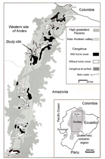
Figure 1. Study site area close to Quito City, Ecuador
With fertilizer N at 80 to 120 kg h-a1 and P at 60kg ha -1, maize can be produced on the cangahua at about 2tha -1 (Zebrowski, 1997). When fertilized with 800kgNha -1, 100 kgPha -1 and 50 kgSha -1 Ray grass (Lolium perenne) can be produced at 25 t ha-1 year (Germain et al., 2000). Nevertheless, theses soils are still prone to erosion, and De Noni et al. (2001) recorded losses of 100 t ha-1.
The aim of this study is to compare the evolution of soil structural stability in soils initially totally deficient in organic matter, after different complete cultivated cycles, on plots with (i) different soil preparation (production of coarse or fine fragments), (ii) different inputs of organic matter which is supposed to improve soil structural stability (Perfect and Kay, 1989; Haynes et al., 1991; Tisdall and Oades, 1982) and, (iii) different fine root densities of low yields and high yields pasture plots with mycelium production, which is also considered as improving the soil structural stability (Reid and Goss, 1981; Gale et al., 2000).
Material
The study site
The study area is located at the experimental farm of the Faculty of Agronomic Science of the Central University of Ecuador. It is situated near the city of Tumbaco, 20 km east of Quito near the Ilaló volcano, at an altitude of 2,465 m (Figure 1). This area is representative of the area where cangahua layers occur as earlier described by Winckell and Zebrowski (1992). The climate is equatorial mesothermic semi-humid. The annual average rainfall is 730 mm with two rainy seasons. The main season is from January to June and the minor one from October to November-December. The monthly average temperature is 15.7ºC with only minor annual variation. The relative air humidity is 75% and there are over 2,000 hrs of yearly insolation.
Before rehabilitation
The hard cangahua is covered locally by a layer of loose sandy ash (up to 50 cm thick) of Holocene age. The hard material appears at the surface when the most recent ash not indurate has eroded. The layers of cangahua in Ecuador are typically 50 cm but can be thicker, continuous, and with no structure. Like a soil horizon, they lie approximately parallel to the land surface. They consist of acidic volcanic ash with the composition of a weathered rhyolite or dacite. The material is hard but apparently weakly cemented, though the cementing agent has not been identified yet.
The unfragmented cangahua
When cangahua layers form the soil surface, they appear as made of tightly packed millimetric aggregates and thus as resulting from pedological processes. Weathering of isolated blocks of cangahua produces two types of fragments: (i) individual rounded fragments ranging from 2 to 10 mm in size that can be considered as weathered accretionary lapilli and, (ii) angular fragments of varying size, most ranging from 1 to 5 mm in size and including the lapilli. It seems that the deposition of the ash and lapilli was accompanied by heavy rains leading to the formation of a mud that cemented and hardened when it dried (Fischer and Schmincke, 1984). The cangahua material is porous but most pores are closed vesicles up to 200 µm in diameter. This structure does not readily transmit water, which therefore runs off when it rains heavily, leading to erosion.
The formation of a new material
To bring the land back into production, the hard layers are broken up by machines with teeth 60 cm deep. Thus large blocks are produced and then further fragmented by ploughing. The result is a material into which crops can be sown but that is almost totally lacking in organic matter (<0.1%) and deficient in nitrogen (N), phosphorus (P) and sulphur (S) for plant growth.
The cangahua has a neutral pH ranging between pH 6.5-7.5 in the presence of carbonate, and a high level of and well-balanced exchangeable cations (Table 1). However the organic matter content is very low and these formations have a very strong deficiency in N and P. The particle-size distribution that was measured randomly at three different depths before the experiment showed a rather homogenous composition in the whole plots with most particles in the fine sand and fine silt fraction (Table 2). The bulk density of this hard material is about 1.5 Tm -3.
Table 1. Particle size distribution in three plots of the La Tola site
|
Sample |
depth |
Particle size distribution |
||||
|
Plot |
/cm |
CS | FS | CSi /% |
FSi | C |
| 1-WFc | 0-5 | 20.7 | 30.4 | 9.8 | 32.7 | 6.4 |
| 6-GREEN | 5-15 | 23.7 | 27.4 | 5.4 | 34.2 | 9.3 |
| 9-NPKf | 15-25 | 34.5 | 27.5 | 7.1 | 22.9 | 7.9 |
CS: coarse sand 2,000-200 µm; FS: fine sand 200-50 µm; CSi: coarse silt 50-20 µm; FSi: fine silt 20-2 µm; C: clay <2 µm
Table 2. Main chemical properties of the surface horizon (0-10 cm) at the La Tola site
|
Exchangeable cations |
Organic matter |
P |
pH |
|||||||
| Ca2+ | Mg2+ | K+ | Na+ | CEC | C | N | C/N | P | in water |
in KCl |
|
/cmol (+) kg-1 |
/g kg-1 |
/mg kg- |
||||||||
| 7.9 | 5.5 | 0.7 | 0.4 | 18.8 | 4.1 | 0.54 | 7.6 | 457 | 6.85 | 5.20 |
Methods
The rainfall simulation
Four rainfall simulation experiments were conducted over a 36 months period using a methodology adapted after Casenave and Valentin (1992). Three successive rainfall simulations (S1, S2 and S3) were conducted prior to the establishment of the agronomic treatments on small TEST plots, and the last rainfall simulation (S4) occurred after the third cropping cycle (Table 3) on larger cultivated plots. The rainfall simulator (Asseline and Valentin, 1978) generated artificial rains with controlled parameters (intensity, frequency, and duration) over 1 m2 plots. Each rainfall simulation consisted of three successive runs. The second run occurred three hours after the end of the first run, and the third run 12 hours after the end of the first rain event. Each run lasted 60 minutes and comprised four continuous sub-runs of 15 minutes with intensities of 20, 40, 60 and 80 mm h-1. Runoff water was collected at intervals depending on runoff rates. The turbidity (soil charge related to water volume) and the soil losses (C en gm-1) were measured.
Before the agronomical trial, three replicates were performed for S1 in the centre of two plots 9 m2 in surface area, manually tilled to a depth of 40 cm. Every plot was prepared to produce surfaces with contrasting average clod size, one plot where averaged clod size was about 5 cm (fine clods, F) and another plot where their averaged size ranged from 5 to 10 cm (coarse clods, C). The second rainfall simulation (S2) occurred one month after S1 on a bare soil surface that was exposed to natural rainfall events. The third rainfall simulation (S3) was conducted again one month after S2, immediately after a soil tillage to brake down the structural crust produced from the provider two simulations and natural rain.
During the agronomic trial, the fourth rainfall simulation was implemented on five distinct terraces on 9 plots. Three replications were undertaken in each cultivated plots.
The agronomic trial
Five homogenous levels of cangahua with a step of 1 m high were chiselled to a depth of 60cm using a bulldozer and levelled into five flat terraces of 6 × 50 m2. The rootable soil did not exceed 40 cm in depth. Each plot had a surface of approximately 100 m2 (4.5 × 22 m2). Initially, five plots were fragmented in coarse fragments (C), and fine fragments (F). Five fertilization strategies were studied on both preparations during the 5 cycles of cultivation (Table 3; Podwojewski and Germain, 2005):
Table 3. Calendar of rainfall simulation and cultivation
|
Year |
J | F | M | A | M | J | JI | A | S | O | N | D |
| 96 |
S1 |
S2 |
S3 |
T0 |
||||||||
| 97 |
T1 |
|||||||||||
| 98 |
T2 S4 |
|||||||||||
| 99 | T3 | |||||||||||
| 00 | T4 |
| Vicia sp. | Pisum sativm | ||
| Hordeum vulgare | Lolium hybridum *tetralite and Avena sativa | ||
| Zea mays | S1, S2, S3, S4: Rainfall simulation - T0, T1, T2, T3, T4: structure sampling | ||
Samples were collected at different stages of cultivation as shown in Table 1. After 3 years cultivation, every plot was divided in 10 subplots for a cycle of perennial cultivation of Lolium hybridum, v. tetralit (ryegrass) or a cycle of Avena sativa (oat). Three fertilization strategies were applied on each subplot: L (low): 60 kg N, M (medium): 280 kg N, H (high): 960 kg N and 60 kg P. After four year’s cultivation: the last sampling was made after nine cuts made every five weeks.
Analytical methods
The aggregate stability was measured with a methodology adapted from Kemper and Rosenau (1986). This size of 1 mm sieve used to discriminate macro and microaggregates is slightly different from the 250 µm usually adopted, because this size corresponds to the fine sand fraction, the most important granulometric class of the texture composition. Selective extractions of iron (Fe) were made with the citrate-dithionite-bicarbonate (CDB) method (Mehra and Jackson, 1960). The Fe concentration in the extract was measured using an ICP-AES spectrophotometer (IRD laboratory, Bondy, France). The grain-size distribution was determined on 10 g of soil after destruction of organic matter by H202, after hexametaphosphate treatment and 30 minutes ultrasonic dispersion. The coarse silt (0.02-0.05 mm), fine silt (0.002-0.02 mm) and clay fraction (<0.002 mm) were determined with an X-Ray sedigraph (IRD laboratory, Bondy, France). The bulk density of hard cangahua fragments was determined by the paraffin method with five replicates.
Mineralogical determinations were made on two samples in the two western and eastern edges of the same terrace showing the most extreme behaviour. Mineralogical composition was determined by the clay fraction X-ray diffraction (XRD) with CuK-radiation. The shrinkage curves were made with a laser telemeter (Podwojewski and Germain, 2005).
Results and discussion
Runoff coefficient
In the undisturbed cangahua, the permeability is very low due to the small access to the pores. The runoff is close to 100% thus corresponding when present in the soil to a vertical discontinuity for water infiltration and consequently to a level lateral internal runoff. Another consequence is the great erodibility of the material above. Thus in its massive state, the permeability of cangahua is restricted due to small pore size resulting in a significant runoff and this predisposes the soils to significant erosion.
The values of the runoff coefficient (Kr) are presented in Table 4. In the test plots, during S1, the Kr values were <5% with a slight increase from the first to the third rain event. As suggested by Poesen and Ingelmo-Sanchez (1992), the presence of coarse elements favours the vertical circulation of water. However, during S2, Kr increased rapidly and regularly from the first to the third rain event. Kr increased from 12 to 16% on coarse preparation and from 24 to 32% on fine preparation (Table 4). During S3 after soil surface removal, Kr was low again but only for the first rain event.
For the cultivated plots (S4) and during the first rain event, the higher values of Kr occurred on plots located on the western part of the trial. For the second rain event, an important increase in Kr is observed on all plots. For the third rain event, all plots showed a moderate increase in runoff. Total runoff had important values over 50%. Comparative to the first rain, the increase in Kr appeared to be the same, approximately 40%.
Table 4. Runoff water coefficient (Kr in %)
| Preparation |
Kru (%) |
|||||
|
Coarse |
Fine |
|||||
| Rain 1 | Rain 2 | Rain 3 | Rain 1 | Rain 2 | Rain 3 | |
|
Simulation 1 – TEST |
0.4 | 1.7 | 4.4 | 0.1 | 0.3 |
0.5 |
|
Simulation 2 – TEST |
12.1 | 16.2 | 16.4 | 23.8 | 28.7 |
32.5 |
|
Simulation 3 – TEST |
3.4 | 6.7 | 13.3 | 1.6 | 6.2 |
7.4 |
| Simulation 4 | ||||||
|
Plots – OM |
49.5 | 76.0 | 82.7 | 41.1 | 73.0 | 79.9 |
|
Plots GREEN |
32.7 | 54.7 | 74.4 | 38.7 | 76.2 | 83.4 |
|
Plots WF |
38.5 | 61.8 | 76.4 | 37.6 | 62.3 | 69.5 |
| Plots NPK | 19.4 | 50.4 | 62.9 | 26.9 | 54.8 | 65.0 |
|
Plots BARE |
21.8 | 61.0 | 72.2 | |||
In gray: plots located in the western part of the trial with higher expansive clay content.
Soil loss
The soil detachment occurs generally when rainfall intensities exceed 40 mm h-1. In the cultivated experiment, BARE and WFc plots soil loss occurred for intensity lower than 40 mm h-1 rainfall. Soil loss increased sharply between 60 and 80 mm h-1. Soil detachment generally increases from the first to the third rain event (Table 5).
Prior to the implementation of agronomic treatments, soil loss was negligible after the first rainfall simulation (Table 5). For S2, the total soil loss for both the coarse and fine land preparation treatments was very similar (135 g m-2). For S3, after the soil tillage, on the coarse plot the soil loss values were still high and decreased slowly from the first to the third rain event. For the fine preparation the soil loss was relatively constant and was half of that recorded during the second rain event.
In gray: plots located in the western part of the trial with higher expansive clay content.
For the far simulation (S4), on cultivated plots, for a total of 50 mm of rain in one hour during each rain, the soil loss varied from 30 to approximately 180 g m-2 except for the bare surface where soil loss was much higher than for the other plots (from 400 g m-2 to over 800 g m-2). The highest rate of soil loss was observed on plots located to the west of the experiment.
Table 5. Soil loss and structural stability
|
Erosion |
Unstable wet aggregates |
||||
| Rain 1 | Rain 2 | Rain 3 | Total rains | ||
| g.m-2 |
g.m-2 |
g.m-2 | g.m-2 | g.100g-1 | |
| S1 coarse | ± 0 | ± 0 | ± 0 | ± 0 | |
| S1 fine | ± 0 | ± 0 | ± 0 | ± 0 | |
| S2 coarse | 31.3 | 77.1 | 30.7 | 139.1 | |
| S2 fine | 26.8 | 61.7 | 45.1 | 133.6 | |
| S3 coarse | 46.2 | 37.0 | 26.7 | 109.9 | |
| S3 fine | 19.9 |
17.2 |
20.0 |
57.1 |
|
| OMc | 88.4 | 98.4 | 106.5 | 293.4 | 39.5 ± 2.9 |
| OMf | 111.2 | 138.0 | 164.2 | 413.5 | 23.9 ± 5.9 |
| GREENc | 45.9 | 56.4 | 82.1 | 184.4 | 13.4 ± 3.2 |
| GREENf |
96.4 |
121.5 | 182.4 | 400.3 | 30.9 ± 6.3 |
| WFc | 124.0 | 144.4 | 184.7 | 453.0 | 23.7 ± 4.1 |
| WFf | 64.4 | 59.5 | 36.8 | 139.2 | 12.8 ± 0.6 |
| NPKc | 37.1 | 58.5 | 37.7 | 132.8 | 13.0 ± 6.7 |
| NPKf | 29.3 | 45.4 | 55.0 | 129.7 | 8.2 ± 1.4 |
| BAREc | 478.1 | 956.3 | 836.2 | 2,270.6 | 49.3 ± 14.7 |
| BAREf | 20.2 ± 4.5 | ||||
The structure stability
There is a good relation between the rate of unstable aggregates and runoff or soil detachment as suggested by Barthès et al. (2000). The ANOVA made at T4 shows that soil preparation, and grass root and mucilage production had no significant effect on structural stability; only the sampling location on plots with different mineralogical properties had a high significant influence (Podwojewski and Germain, 2005).
After a 3 year period of cultivation (T3), the percentage of unstable wet aggregates increased significantly. All these plots with even numbers are located in the western part of the experiment. Plots with a dry matter production of 3 t ha-1 on the same terrace were not significantly different in structural stability from ones with micro plots with a dry matter production of more than 20 t ha-1. The level of accumulated aboveground biomass of ryegrass did not influence the structural stability significantly in one-year rye grass cultivation.
The soil components
Structural stability and carbon content
The neoformation of a typical soil structure and its stability is generally linked to carbon content (Tisdall and Oades, 1982), especially with root derived carbon (Gale et al., 2000) and is the result of biological activity and organization of clay-organic matter stable bounds. In the case of cangahua, in early stages of an agricultural management, soil fragments have a structural stability independent of the presence of surface mycelium, density of roots and/or carbon contents.
For a positive effect on structural stability, the rate of organic matter should be higher than 2% in temperate climates. As there is no linear correlation between organic matter rate and structural stability (Perfect and Kay, 1989), the weak structural stability could be attributed to a weak concentration of organic matter, which was less than 3% even in plots with the highest rate of organic matter inputs. The values of C content are still low after inputs of over 80 t ha-1 of manure. The total lack of carbon in the cangahua formation could be attributed to rapid carbon mineralization. In similary soils in Mexico, after four months, more than a third of the input was mineralized (Etchevers et al., 1997).
Structural stability and clay-content
After 3 years of cultivation, the particle-size distribution was different at the soil surface. Compared with the initial particle-size distribution in all plots, the coarse sand content decreased strongly and, conversely, the clay fraction and also the coarse silt fraction content increased. In the eastern part of the trial, plots were composed of homogenous material poor in clay, while the extreme western part showed an increase in clay content.
The X-Ray determinations of the oriented clay fraction showed no well-defined crystalline clays. However, a base line with an apparent higher intensity between 1 and 1.5 nm appears for samples with a larger content of clay-sized material. Nevertheless, this clear difference cannot be interpreted as a difference of clay type or clay crystallinity.
The lack of mineralogical clay restricts the constitution of bonds between clay and organic matter which form stable aggregates. But in the case of cangahua we observed that an increase in clay content corresponds to an increase in the rate of unstable aggregates and the aggregate stability may be related to iron oxides bounds (Figure 2). This unstable behaviour could be linked to the swelling-shrinkage properties. The clay-rich fragments present a shrinkage percentage between 5 and 8% after drying while the poor clay fragments had a shrinkage percentage of less than 1% (Figure 3). This behaviour confirms the presence of swelling material, maybe proto-clays, which are much higher than the poor-clay samples and could be responsible for the scattering of the fragment components. In our case, iron oxides are probably part of the particles cohesion rather that amorphous silica. Therefore soil tillage could be partly responsible for high soil dispersion.
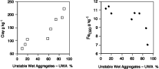
Figure 2. Relation between UWA and cangahua clay and Fe (cbd extract) contents.
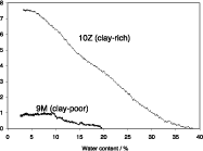
Figure 3. Shrinkage curves in function of water-content of clay poor (Plot 9M) and clay-rich (Plot 10Z) fragments
The cangahua can be considered as a rock in weathering process with higher expansive clay contents in the western part of the trial, especially in places were are localized the Bare plots. During this process, we observed a transition between the soil fragments to a soil structure. This transformation seems to be higher in the presence of strong biological activity in plots enriched with organic matter. Cemented fragments of hardened volcanic ashes have a stronger stability than the recent formed aggregates due to biological activity, which are therefore more prone to erosion than the previous soil fragments.
Geomorphologic and agronomic consequences
Coarse soil preparation and the conservation of hard fragments temporary limit the risk of runoff and erosion. However rapid infiltration can lead to the accumulation of water at the top of an impermeable untilled cangahua layer and therefore, generating landslides (Perrin et al., 2000). Fine soil preparation increases the crusting of the topsoil. It could limit erosion by increasing runoff but only in the first steps of the erosion process. The concentrated runoff can lead rapidly to the formation of gullies first step to the removal of the hardened layers.
Due to rapid crusting and strong sensitivity to erosion, flat terraces are recommended. Because of the high cost of work, terraces of slow formation with a limited slope of 10 to 15% and protected downstream by a wall in a cangahua itself have been experimented with successfully and are now adopted in some agricultural communities (De Noni et al. 2001; Zebrowski et al., 1997). These terraces by the time and a generalized sheet erosion.
In Mexico, where much work has been done on erodibility of tepetates, rainfall occurs once a year during a well-defined rainy season. In case of annual traditional crops like maize, the higher intensity corresponds to a period with maximum vegetation development so that the soil cover is at its maximum. However, in Ecuador, there are two distinct rainy seasons and very heavy rains can occur between two cultivation cycles so that bare soil could be exposed to erosion.
The potential production of Ray Gras could be estimated to 6 t ha-1 every 5 weeks. This potential production could be approach and Yields can reach over 5 t ha-1 after each cut, over 40 t ha-1 in irrigated condition with an initial N fertilization of 120 kg ha-1 and 80 kg ha-1 every 5 weeks, and 160 kg ha in P. Higher is the rate of N fertilization, higher will be the needs in P and after the 3rd cut, Ray grass shows deficiencies in K and S, which could be surprising in a volcanic environment. If K sulphate is introduced since the beginning of the trial, the high yields are constant after one year production (Germain et al., 2000).
High inputs of organic matter are unlikely because of their high cost, limited availability, and their very fast mineralization. The best solution for agricultural development of the cangahua surface may be the planting of a perennial grass pasture. The fibrous root system of the grasses not only ramifies and opens up the soil but also encompasses individual crumbs in a net-like web to form crusts resistant to the slaking action of water (Tisdall and Oades, 1982; Kay, 1990; Reid and Goss, 1981). Any other cultivation must be made with minimum tillage.
Conclusion
In the early stages of cangahua removal, water infiltration is rather complete. But since one month of exposure to natural rains crusting limits runoff. Crusting occurs rapidly especially when the soil is left without soil cover and when it has fine fragments. After soil tillage, the runoff is only temporarily reduced, and increases regularly after each rain. After three cycles of cultivation, there is no major difference in behaviour between coarse and fine preparation. Crusting is very fast and limits the pre-pounding rain even in plots with higher porosity.
After four years of cultivation, soil preparation, organic matter inputs, root density and mucilage production had no effect on the aggregate structure stability. Initial structural stability of fragments is determined by their mineralogical composition: clay-rich material with shrink-swell properties is less stable than material containing low amounts of clay, with less shrink-swell properties and higher iron oxides contents. Their contrasting attributes are a result of progressive weathering and therefore, influence erosion processes.
Runoff and erosion develop after cultivation and are particularly important in plots with the highest rate of unstable aggregates with high expansive clay content. The introduction of organic matter probably generates a new pedological structure, but does not improve general structural stability, probably because it is present in insufficient amounts. However, organic matter fertilizers need more tillage and the new pedological structure is much weaker than the lithological fragments that form the initial structure.
To avoid any risks of erosion, soil preparation should be coarse to limit the effect of erosion in the early stages of plant development. These soils must be cultivated on flat areas, be protected by a perennial crop (pasture), which may produce an improvement in soil stability though its roots and slowly develop a new stable pedological structure different from the fragmented lithological structure. Volcanic ash soils could be deficient in S.
References
Asseline, J., Valentin, C., 1978. Construction et mise au point d’un infiltromètre a aspersion. Cah. ORSTOM. Série hydrologie, X V, (4), 321-349.
Barthès, B., Azontonde, A., Boli, B.Z., Prat, C., Roose, E., 2000. Field scale runoff and erosion in relation to topsoil aggregate stability in three tropical regions (Benin, Cameroon, Mexico), European Journal of soil research, 51: 485-495.
Casenave, A.,Valentin, C, 1992. A runoff capability classification system based on surface features criteria in semi-arid aeras of West Africa. Journal of Hydrology, 130: 231-249.
De Noni, G., Viennot, M. Asseline, J. and Trujillo, G. 2001. Terres d’altitude, terres de risque. La lutte contre l’érosion dans les Andes équatoriennes. Latitudes, 23, IRD Paris.
Etchevers, J.D., Pérez, M.A. & Navarro, G. 1997. Dinámica de la materia orgánica y el N en tepetates habilitados para la producción agrícola. In: Memoria del III Simposio Internacional sobre Suelos Endurecidos (Quito, diciembre de 1996), (eds C. Zebrowski, P. Quantin & G. Trujillo), pp. 213-224. IRD, PUCE, UCE, Quito.
Fischer, R.V. & Schmincke, H.U. 1984. Pyroclastic Rocks. Springer-Verlag, Berlin.
Gale, W.G., Cambardella, C.A., and Bailey, T.B., 2000. Root-derived carbon and the formation and stabilization of aggregates. Soil Sci. Soc. Am. J., 64: 201-207.
Germain N., Duran M. et Podwojewski P., 2000. Fertilité d’un sol volcanique induré récupéré et fertilisation raisonnée d’un ray grass. Fertility of reclaimed volcanic ashsoil and comprehensive fertilizer management of ryegrass. Symposium “Soil functioning under pastures in intertropical areas”. Brasilia, 16-20 octobre 2000.
Haynes, R.J., Swift, R.S. & Stephen, R.C. 1991. Influence of mixed cropping rotations (pasture-arable) on organic matter content, water stable aggregation and clod porosity in a group of soils. Soil and Tillage Research, 19: 77-87.
Kay, B. 1990. Rates of change of soil structure under different cropping system. Advances in Soil Science, 12: 1-52.
Kemper, W.D., and Rosenau, R.C, 1986. Aggregate stability and size distribution. In: Methods of soil analysis, Part 1. Physical and mineralogical methods. Klute, A.Ed., Agronomy monograph n°9 (2nd edition), SSSA Book Series: 5, 425-442.
Mehra, O.P, and Jackson, M.L., 1960. Iron oxide removal from soils and clays by dithionite-citrate systems buffered with sodium bicarbonate. Clays and clay miner, 7: 317-327.
Perrin, J.L., Fourcade, B., Poulenard, J., Richard, D. et Sierra, A., 2000. Quito face à un risque d’origine naturelle: les laves torrentielles. Revue de géographie alpine, n°2, 43-57.
Perfect, E. and Kay, B.D., 1989. Relations between aggregate stability and organic components for a silt loam soil. Can. J. Soil Sci, 70: 731-735.
Podwojewski, P. and Germain, N., 2005. Evolution of the soil structure in a deep tilled hardened volcanic ashsoil (Cangahua) in Ecuador. European Journal of Soil Science, 39: 39-51.
Poesen, J., Ingelmo-Sanchez, F., 1992. Runoff and sediment yield from topsoils with different porosity as affected by rock fragment cover and position. Catena 19: 451-474.
Reid, J.B. and Goss, M.J., 1981. Effect of living roots of different plant species on the aggregate stability of two arable soils. J. Soil Sci., 32: 521-541.
Tisdall, J.M. and Oades, J.M. 1982. Organic matter and water-stable aggregates in soils. Journal of Soil Science, 33, 141-163.
Winckell, A. and Zebrowski, C, 1992. La cangahua en Equateur: le contexte paléogéographique de sa formation. In: Terra, vol. 10, Zebrowski et al. eds, Numero Especial Suelos Volcénicos Endurecidos, 107-112.
Winckell, A. and Zebrowski, C, 1997. Los paisajes andinos de la sierra del Ecuador. In: Los paisajes naturales del Ecuador. A. Winckell (Editor), CEDIG, Quito, Geografia basica del Ecuador. IV, (2), 3-207.
Zebrowski, C. 1997. Los suelos con cangahua en el Ecuador. In: Memoria del III Simposio Internacional sobre Suelos Endurecidos (Quito, diciembre de 1996), (eds C. Zebrowski, P. Quantin & G. Trujillo), pp. 128-137. IRD, PUCE, UCE, Quito.
1 IRD-IWMI, Hanoi, Vietnam;
2 IRD-IWMI, Bangkok, Thailand
![]()
![]()
![]()