![]()
![]()
![]()
Golabi, M.1 and A.M. Akhoonali2
|
Abstract Problems associated with areas around sandy soil hills are significant as soils picked up by wind result in soil erosion, desertification, human health problems and finally migration of farmer and people from these areas. These issues are important in desert management. For many years mechanical, chemical, physico – chemical and biological methods have been used to stablilize running sands in many countries. By undertaking these methods that are costly sands are often stablilized but with little economic benefit. In order to control soil loss from these areas the preservation of plant coverage through agriculture is a method that is often viewed as highly desirable. However, a problem associated with these soils is their high level of infiltration and deep percolation when common irrigation methods are used. However, small scale irrigation methods such as drip and porous pipe irrigation methods may produce better results as they provide water to the root system at a minimum level and at an adeqaute rate thereby minimizing deep percolation. In this way the subsurface leaky pipe irrigation method with vertical option was used at Albaji sand hills which are located in 28 kilometer of Ahvaz – Andimeshk road, Khuzestan Province in Iran in October 2003. To monitor the soil moisture pattern, five pieces of leaky pipe sections, 22 mm in diameter and lengths of 30, 45 and 60 cmwere installed on a polyethelene pipe with a 32 mm diameter and with 1.5 m distance between each piece of leaky pipe. Three heads of pressure were applied: 2, 4 and 6 m of water. The moisture patterns were observed along the pipe on a cross sectional basis and vertical and horizontal expansion of the wettting front were recorded. The moisture content at 10 points within the wetting pattern were measured with time. The results indicate that this system is suitable for light textured soils since it controls deep percolation with time and requires minimum pressure to operate. |
There are many areas around the world which are associated with sandy soils. Because these areas are often associated with arid or semi-arid climatology, crop coverage as a means for preventing soil erosion is minimal and sandis blown away by wind erosion. Therefore, agricultural lands around these areas are affected by desertification.
About 300,000 ha of sandy lands exist in Khuzestan Province in Iran and are surrounded by the Karkheh and Karoon Rivers. Because of the existence of a high rate of infiltration for sand in these areas, irrigation water is easily lost by deep percolation. Fortunately, salinity is not major in these sandy soil because of the high level of infiltration but a suitable method for irrigation is needed to manage these soils. A successful irrigation method will develop crop coverage which results in the prevention of wind erosion, development of an agricultural economy, and improved health and social affairs. It seems that the porous pipe irrigation technique is one of the best methods applicable to sandy hills, because it discharges a low level of water allowing slowirrigation. Porous pipe works like a clay pot which was used in Central Iran, Pakistan, India and Egypt centuries ago. Porous pipe can be used at the soil surface or subsurface. This pipe is alled by other names such as ‘Leaky Pipe’ (in USA) and ‘Proflex’, ‘Ecopore’ and ‘Tuporex’ in France. The porous pipe irrigation method is currently used in USA, Europe, Australia, China, Japan and other countries and many researchers such as Fok and Willardson (1971), Tollefson et al. (1985), Yoder and Mote (1995), Teeluck and Sutton (1998), Camp et al. (1998), Khorramian et al. (2001) and Akhoondali (1998, 2003) have evaluated different aspects of this irrigation method. However, these researchers have used this system with a common condition of horizontal installation of the porous pipe irrigation system.
Fok and Willardson (1971) presented a method for analysis and design of a subsurface irrigation system that uses field data, system capacity, depth and distance between pipes and irrigation frequency.
Tollefson et al. (1985) reported a pipe life up to 10 years and successful commercial installations.
Yoder and Mote (1995) evaluated discharging of unused porous pipes. In this study each piece of porous pipe was 0.3 m long and the manufacturing coefficient of variation was calculated for discharges at 14, 34.5, 69 and 138 Kpa pressure. The results showed that variation in discharge along the pipe was substantial for pipes of different series.
Teeluck and Sutton (1998) compared discharge uniformity of pieces of 6 m length under 10 and 20 Kpa of pressure head with filtered water and nonfiltered water. Results showed that for the two types water, discharge decreased with time but, nonfiltered water discharge constantly. Manufacturing coefficient of variation with filtering water was from 20% to 35% and these values were increased with time.
In a review, Camp (1998) reported that lateral drip depths ranged from 0.02 to 0.7 m, depending upon both soil and crop type.
To assess moisture movement in a light-textured soil, Akhoondali (2003) used horizontal porous pipe of 40 cm length at a soil depth of 30 cm and applied pressure heads of 4, 6, 8 and 10 meter of water for time periods ranging from 30-300 min.
The results showed that:
Khorramian et al. (2001), for evaluation of hydraulic characteristics of porous pipes, tested 6 meter lengths of these pipes under pressure ranging from 20 to 100 Kpa. The emission rate was compared and evaluated for three treatments including unused dry porous pipe, unused soaked porous pipe and used porous pipe.
The results indicated that: emission rate was approximately a linear function of pressure; emission rate of unused soaked pipe was always lower than unused dry pipe at constant pressure; and the emission rate in used porous pipe was very low.
As cited above, a lot of research has been done for horizontal setting porous pipe and evaluation of porous pipe characteristics hydraulic was done but, in Iran two research of vertical setting pipe were reported.
Akhoodali (1998) studied moisture movement pattern with vertically installed porous pipe in glass boxes on three types soil; light, medium and heavy textured. For this study three lengths of pipe (30, 45 and 60 cm) of 13 mm diameter were used under 2 m of water pressure and 1, 2, 3, 5, 7, 9, 14, 24, 34, 49, 64, 79, 94, 109, 124, 139, 154, 169, 184 min of time.
Results showed that:
Sandy hills in Khoozestan Province are located between eastern longitude of 47º40' to 49º20' and 31º5' and northern latitude 32º20'. These hills are developed from northwest to southeast and are comprising 3,500 ha and representing 5.4% of the total land area of Khoozestan and 29.5% of the agricultural lands of the province.
Table 1. The soil texture of Albaji hills
|
Particle type |
Coarse sand |
Medium sand |
Fine sand Very fine sand |
Silt |
Clay |
|
Particle diameter (mm) |
0.5-1 |
0.25-0.5 |
0.25-0.1 |
0.002-0.05 |
<0.002 |
| Percent | 0 |
28 |
65.5 |
2 |
2.5 |
| Texture | Sand |
This field study was done in October 2003 at the natural resources station, at Albaji located between 31º20'N 48º40'E and 20 m above sea level.
The field texture of the soil is fine sand, and its particle size analysis is presented in Table 1.
For this test, porous pipe (HD2216) was used. Three lengths of pipe (30, 45 and 60 cm) were provided, and one end was blocked.
For uniformity in each test, unused, dry pipes were used. In this test vertical installation was used for several reasons:
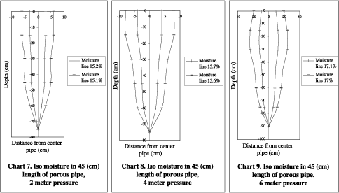
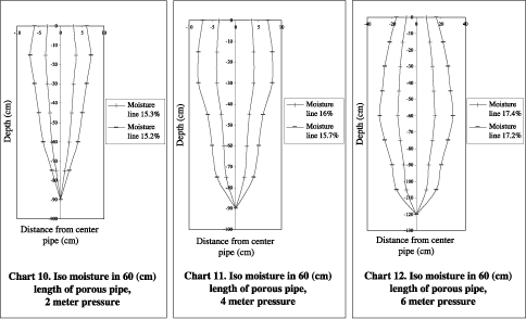
The experiment was done over five times (10, 30, 60, 180 and 300 min) with pressure heads of 2, 4 and 6 meters of water and three lengths of pipe (30, 45 and 60 cm). So, 45 units were involved. In this study, five pieces of leaky pipe of 22 mm diameter were installed on a polyethylene pipe 32 mm diameter and 1.5 m distance between each section of leaky pipe. The polyethylene pipe was linked to a Robine pump that pumped the required water from the source water to the system. The required pressure head was regulated by a control value and a gauge (Figure 1). Wetting patterns were observed along the pipes on a cross section and vertical and horizontal expansion recorded with time. In addition to vertical and horizontal records of soil moisture movement, a set of soil samples were taken from 10 points to measure soil moisture. These points were selected randomly on one side of the pipe. In this paper, the data are presented for the 300 min time period.
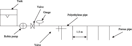
Figure 1. Schematic of system
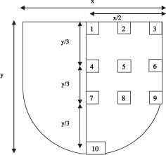
Figure 2. Schematic of moisture profile and the sample points
Results
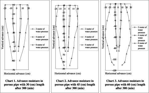
1. Vertical expansion frompipes of 30, 45 and 60 cm length
Table 2 and Figure 3 show that in porous pipe of 30 cm length for 2, 4 and 6 meter water pressure, vertical expansions were 45, 50 and 60 cm, for units of 45 cm length, 60, 65 and 85 cm vertical expansion, and for units of 60 cm length, 78, 85 and 110 cm vertical expansion.
Maximum vertical expansion occurred at 6 meter water pressure, and at this pressure, vertical expansion from the end of the pipe was equal to the length pipe. In other words, at 6 meter water pressure, the total vertical expansion was equal to approximately double the pipe’s length.
2. Horizontal expansion from pipes of 30, 45 and 60 cm length
Table 2 and Figure 3 show that the range of horizontal expansion in pipes of 30 cm length with 2 meter of water pressure was from 5 to 12 cm, with 4 meter of water pressure from 5-15 cm and at 6 meter of water pressure from 12 to 38 cm. For pipes of 45 cm length with 2 meter of water pressure, horizontal expansion ranged from 6 to 12 cm, at 4 meter of pressure from from 6 to 16 cm and at 6 meter of water pressure from 13 to 48 cm. For pipes of length 60 cm2 meter of water pressure, horizontal expansion was from 4 to 13 cm, for 4 meter water pressure from 5 to 16 cm, and for 6 meter of water pressure, from 20 to 60 cm. These data show that horizontal expansion was changed a little by changing the length of the pipe. However, with variation in pressure, horizontal expansion changed much more, particularly from 4 to 6 meter of water pressure. This pipe was designed for 6 and 8 meter water pressure.
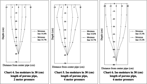
3. Moisture diagram
Table 3 and Figures 4-12 show that soil moisture decreases at the front of the wetting pattern because of the decreasing matrix potential gradient from pipe to wetting front. Along the pipe the amount of moisture increased because of increasing gravity force and with increasing pressure, the amount of moisture increased because of increasing discharge.
Table 2. Vertical and horizontal expansion (cm) in porous pipe after 300 min
| X, |
y |
x2 |
x1 |
y |
X2 |
X1 |
y |
X2 |
X1 |
y |
X2 |
X1 |
y |
X2 |
X1 |
y |
X2 |
X1 |
y |
X2 |
X1 |
y |
X2 |
X1 |
y |
X2 |
|
6 |
0 |
6 |
6 |
0 |
6 |
19 |
0 |
18 |
6 |
0 |
6 |
7 |
0 |
8 |
19 |
0 |
19 |
6 |
0 |
6 |
7 |
0 |
7 |
18 |
0 |
16 |
|
6 |
15 |
6 |
7 |
15 |
8 |
19 |
15 |
19 |
6 |
15 |
6 |
8 |
15 |
8 |
23 |
15 |
24 |
6 |
15 |
7 |
8 |
15 |
8 |
21 |
15 |
22 |
|
5 |
30 |
5 |
5 |
30 |
6 |
15 |
30 |
15 |
5 |
30 |
5 |
7 |
30 |
6 |
24 |
30 |
24 |
6 |
30 |
6 |
7 |
30 |
8 |
26 |
30 |
26 |
|
2 |
45 |
3 |
4 |
45 |
4 |
11 |
45 |
12 |
5 |
45 |
5 |
6 |
45 |
5 |
19 |
45 |
18 |
5 |
45 |
5 |
6 |
45 |
6 |
29 |
45 |
28 |
|
2 |
50 |
3 |
7 |
60 |
5 |
3 |
60 |
3 |
5 |
60 |
4 |
17 |
60 |
16 |
4 |
60 |
4 |
5 |
60 |
5 |
30 |
60 |
30 |
|||
| 3 | 65 | 3 | 12 | 75 | 11 | 2 | 78 | 2 | 4 | 75 | 4 | 25 | 75 | 26 | ||||||||||||
| 6 | 85 | 7 | 3 | 85 | 2 | 20 | 90 | 20 | ||||||||||||||||||
| 15 | 105 | 16 | ||||||||||||||||||||||||
| 10 | 110 | 10 | ||||||||||||||||||||||||
Table 3. Gravimetric moisture content at 10 points in the wetted profile around porous pipe after 300 min
|
2 |
4 |
6 |
2 |
4 |
6 |
2 |
4 |
6 |
|
| 1 | 14.7 | 14.9 | 16.3 |
15.2 |
15.8 |
17.1 |
15.4 |
16.0 |
17.5 |
| 2 | 14.5 | 14.6 | 15.0 |
15.0 |
15.5 |
16.8 |
15.2 |
15.8 |
17.0 |
| 3 | 14.1 | 14.2 | 14.8 |
14.9 |
15.3 |
16.5 |
15.0 |
15.5 |
16.7 |
| 4 | 14.9 | 15.1 | 16.5 |
15.4 |
16.0 |
17.4 |
15.6 |
16.2 |
17.7 |
| 5 | 14.8 | 14.8 | 15.4 |
15.1 |
15.6 |
17.1 |
15.3 |
16.0 |
17.4 |
| 6 | 14.4 | 14.5 | 15.0 |
15.0 |
15.5 |
16.9 |
15.2 |
15.6 |
17.0 |
| 7 | 15.0 | 15.3 | 16.7 |
15.6 |
16.2 |
17.7 |
15.7 |
16.4 |
17.9 |
| 8 | 15.1 | 15.0 | 15.5 |
15.4 |
15.9 |
17.3 |
15.4 |
16.1 |
17.7 |
| 9 | 14.7 | 14.7 | 15.2 |
15.3 |
15.7 |
17.0 |
15.2 |
15.8 |
17.3 |
| 10 | 15.5 | 15.5 | 15.6 |
15.5 |
16.0 |
17.6 |
15.5 |
15.9 |
17.8 |
The authors are grateful to Khuzestan water and power authority and research and standard of irrigation and drainage network office for their support.
Akhoonali, A.M. 1998. Determining moisture pattern for Khuzestan soils with subsurface leaky pipe irrigation. Research No. 486. Iran, Ahvaz, Shahid Chamran University.
Akhoonali, A.M. 2003. Evaluation of applying porous pipe with vertical option. Research No. 406. Iran, Ahvaz, Shahid Chamran University.
Barootzadeh, M. 1999. Evaluation of the possibility of tillage potato in sandy hills using drip irrigation. M.S. Thesis. 13-20.
Khorramian, M. and M. Mirlatifi 2000. Evaluation of Tarava porous pipe performance. Soil and Water Sciences Journal. Soil and Water Research Institute No. 2. 187-188.
Camp, C.R. 1998. Subsurface drip irrigation. A review Transaction of the ASAE. vol. 41(5), 1353-1367.
Fok, Yu. Si and Willardson, L.S. 1971. Subsurface irrigation system analysis and design. Journal of the Irrigation and Drainage Division, ASCE. Vol. (97). NO. IR3, 449-454.
Teeluck, M. and B.G. Sutton. 1998. Discharge characteristics of porous pipe micro irrigation lateral. Agric. Water Management. 38(2), 123-134.
Tollefson, S. 1985. The Arizona system, Drip irrigation design for cotton. In ‘Proc. Third International Drip, Trickle Irrigation Congress ASAE, 401-405.
Yoder, R.E. and C.R. Mote. 1995. Porous pipe discharge uniformity. Micro irrigation for a changing world. Conserving resources/preserving the environment. Proceedings of the Fifth International Micro Irrigation Congtress, ASAE, Orlando, Florida.
1 Ph.D. Student, Department of Irrigation Engineering, Faculty of Water Science Engineering, University of Shahid Chamran, Ahvaz, Iran, [email protected]
2 Assistant Professor, Department of Irrigation Engineering, Faculty of Water Science Engineering, University of Shahid
Chamran, Ahvaz, Iran.
Penning de Vries, F.W.T.1; S. Ruaysoongnern2 and S. Wong Bhumiwatana3
|
Abstract Water is a limiting factor on farms in Northeast Thailand because of weather and soils. Variable rainfall leads to high risks in cultivation. Catching and storing rainwater and subsequent use for irrigation reduces risk and increases farm productivity. A practical question posed by farmer organizations is ‘what is the optimal size of a farm pond?’ In trials, optimum values of around 12% of the farm area have been reported. For individual farms, however, this fraction may be much different due to features of farm soils, landscape and local climate, economic factors (prices of produce and multiple productive uses of water) and the preferred farming style (i.e. the farming household minimizes inter-annual risks, maximizes income, is innovative in trying the latest techniques, or has farming as a secondary source of income). To consider a wide range of variables and choices in a systematic and transferable manner, we developed the farm simulation model BoNam-FS (Farm Simulation). It was used to simulate sets of scenario’s (farming styles, soil types, weather patterns, innovations) to determine farm performance over a range of farm pond sizes. Benefits of innovations, such as pond sealing and alternative irrigation methods, can be quantified. The results can be analysed with the spreadsheet BoNam-SA (Scenario Analysis) and summarized in graphs. Results have been presented to farmer organizations to show the options for water management and how to pick a scenario that suits best a specific situation. BoNam-SA is available for further analyses, such as by farm advisors. BoNam-FS is available for in depth analysis of farm water balances in existing or new scenario’s . For detailed explorations, specific data from the farm-in-case are needed. |
Deforestation and unbalanced farming systems have brought much land and water degradation in N.E. Thailand since the 1960’s, particularly by nutrient mining (Bridges et al., 2001). Several farmer organizations (FOs) emerged in N.E. Thailand in the 1980’s (Chamrusphant, 2001), either spontaneously or promoted by NGO’s (Chutikul, 2001, Bepler, 2002). Since the early and mid 1990’s some FOs promoted the adjustment of farming practices to reverse degradation (Ruaysoongnern and Suphanchaimart, 2001). This often included construction of a farm pond and crop diversification. Investments for pond construction are often arranged through revolving funds, managed by the farmers groups, and entail loans that are repayable within 12 months (Bepler, 2002, Ruaysoongnern and Penning de Vries, 2005). In addition to empowering many individuals and setting common action agenda’s, these organizations gained a strong political influence in the government. Significant funds are now available to speed up the expansion of the number of farm ponds. Government spending will be increased further for 2005-2007 as a regional drought in 2004/2005 has given “water” an even higher prioity. The Land Development Department (LDD) advises the government on implementation of the pond development scheme. The new Thai constitution strongly promotes participation of the people in the “conservation, maintenance and use of natural resources” (Hungspreug, 2001), and LDD and FOs search how to make this effective and to design realistic loan schemes for individuals.
Goto and Koike (1997) report that modern farmers near Khon Kaen often cultivate 2-3 ha of land, divided into 2-3 plots and worked with 4-7 persons. On average, 50% of the area is in rice and 10-15% in vegetables. The authors also report that there are usually 1-2 rice crops per year yielding 2.7-3.7 t ha-1 cleaned rice of which only 10% is consumed domestically. Vegetables, 4-5 crops per year, include beans, cabbage and onions, are generally sold to middle men and yield 50-100 k Baht ha-1 yr-1. Pond water is used to irrigate vegetables, flowering plants and fruit trees. Some farmers produce and sell fish as well. Farmers may also grow some trees for convenience wood (e.g. teak, Eucalyptus) for sale when cash is needed. An analysis of modern farming systems and a comparison with non-improved systems has been carried out by Tipraqsa (2005). Cassava, a common crop in N.E. Thailand, is never irrigated and therefore not considered in this study.
The New Theory for agricultural development by His Majesty King Bhumibol of Thailand (LDD, 2005) underlies the thinking of FOs with respect to farm and livelihood development. It promotes integrated farming to achieve household food security, self-reliance and a reasonable income from agricultural products from a farm with ample biodiversity and a sustainable farming system. Farm ponds are crucial in the New Theory (Figure 1).

The water balance on farms is complex. Farm ponds receive water from rain and runoff from the fields and uncultivated surfaces. A high groundwater table may add to filling, but drainage from ponds is more common, particularly on sandy soils. Some farms pump groundwater for domestic and productive uses, but as a salt layer underlies the groundwater in some areas there is a threat that saline water is extracted (Srisuk et al., 2001). Roof water harvesting for domestic water is common (Bepler, 2002); water supply through pipes by water providers is uncommon.
The optimal size of a pond relative to the size of the farm is important but difficult to establish. It is important because the water surface itself is not productive. It is difficult to establish because it depends on many factors: the crops grown (type and area), on the prices they can fetch on the market, the local weather and soil types, and other factors. Also farmer objectives affect the optimum ratio. The track record of new farms is still short (Tipraqsa, 2005), so that farmers have not yet sufficient experiences to be used as a guideline. Experimentally, LDD found 12% to be an optimum (Khao Hin Sorn, 1999). In the New Theory, a pond as large as 30% of the farm surface is proposed. It would allow full irrigation of all crops year round, but could require water supplies from major reservoirs outside the farm. Irrigation only where and when really needed can reduce the water demand significantly and allows smaller and cheaper ponds. Realizing this complexity and local specificity, FOs asked scientists for help and formulated three pertinent questions (Box 1).
Box 1. Three questions to scientists formulated at a
meeting of farmer networks in N.E. Thailand, Kalasin, 20 January 2004; text in parenthesis by the authors.
|
When experience provides no guideline to determine the optimum water/land ratio on farms, trials can be carried out. Such trials should last at least 5-10 years and occur across N.E. Thailand due to the variability of the weather and differences in soils. They are therefore slow to provide conclusions and expensive. The LDD experiment station in Khao Hin Sorn carries out trials in one rainfall zone. An alternative approach, potentially much faster, with a wider range of answers, and cheaper, is through simulation modelling. Optimally, the modelling approach goes together with field research and calibration.
In a dynamic simulation model the way how crops, soils and ponds ‘respond’ to management and weather is calculated for short time intervals (here: one week). Calculations are repeated over periods of 1-10 years. Indicators of ‘farm performance’ are derived from the computed results. With little effort, the simulations can be repeated for many scenarios of farm management to explore the options available to the farmer. Characteristics of weather, soil, landscape, and other factors are kept as close as to the conditions of the end user as feasible. Management is characterized by planting dates and target yields, irrigation methods and mulching. From the values of the indicators in the different scenarios, the farmer can select the outcome that fits his/her farm best.
This way of identifying the optimum farm pond size makes full use of scientific knowledge and of local insights. The modelling approach supports non-specialist with applicable scientific knowledge. Croke et al. (2005) give examples from Australia of the impact of modelling support to local persons and organizations and of the improved water and land management.
Several models have been published that address optimization on farms. These include SWB (Annandale et al., 1999), Tradeoff Analysis Model (Antle and Stoorvogel, 2000), Dam Ea$y (Lisson et al., 2003), Planwat (Van Heerden, 2004) and TechnoGIN-3 (Wolf et al., 2004). But they do not provide all features required to answer the request of the FO (Box 1), particularly not with respect to multiples uses of water, farming styles and weather variability.
Outline. We developed the simulation model BoNam-FS (bon am is Thai for ‘pond’, Farm Simulation) to support farmers across N.E. Thailand to determine the optimum relative pond size for the conditions of any particular farm and for the preferred farming style of its farm manager. The model is built in the language SIMILE (Muetzelfeldt and Massheder, 2003); its outputs can be analysed with MS Excel. Running the model and comparing results for different scenario’s is user friendly. This paper presents briefly our approach in modelling to support FOs and some results obtained with BoNam version 3-09. A copy can be obtained from the first author. The data used to characterize the farms and locations in this paper are from actual observations and from measurements reported in literature. The data, however, may not be representative for a particularly farming situation because we want to demonstrate possible uses in contrasting environments and did not attempt to identify parameters from specific cases.
The actual simulation model consists of 15 modules: one for the water balance of each of five farm plots, one for each of the three productive activities (vegetables, rice and fish), one for inputs with respect to strategic decisions on farm layout and one for operational decisions in management, one for time management, two for weather and price data, and two to track simulated farm performance (water balance, income, etc.) and annual totals. A full description of the model is in preparation (Penning de Vries, 2006). (It is technically straight forward to add modules for other water demanding activities such as for sugarcane, fruit trees, feed crops and livestock. However, the number of farm management options for the users grow too large to be helpful, certainly in the early stages of support in decision-making with the model. Hence we opted at first for a small set of contrasting uses of water in BoNam. Further feedback from farmers may indicate that another selection of activities, or indeed a larger range of water use activities, is required). SIMILE provides transparency of the model and easy inspection and modifications. Several checks and double accounting in the model assure consistency in modelling processes and reduce errors. Because the farming season begins in July and may extend well into the next year with a second rice crop, we compute the annual totals from July onwards. To deal with uncertainty, a normal simulation run consists of 9 consecutive years. This allows the user to take into account carry over effects between seasons and to calculate realistic annual averages and estimate uncertainty.
The first question about an optimum ratio between land and water (Box 1) can be answered by repeating simulations for a range of pond sizes and varying the size of the irrigated plot. The first approach is needed when a farm pond is (re-) designed, the second when optimizing multiple uses of water from a fixed size pond. In this short paper, we deal with variable sizes.
Farm layout: the default farm surface area is 1 hectare; other values can be specified. It consists of five sections: (i) the farmhouse, yard and the unplanted area surrounding the pond, (ii) the pond, (iii) the rice field, (iv) a plot with vegetables and (v) a park with trees (Figure 2). Only the vegetable crop is irrigated, if possible, not the transplanted rice. Recognizing the importance of rice production for the household, any increase in pond area is at the expense of the vegetable plot. The water balance connects the plots, if there is excess water on the plots, it runs into the reservoir; if there is too much for it to contain, it runs off from the farm. Runon from nearby roads or field can be important. The dynamics of groundwater is insufficiently known to be simulated.
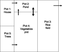
Figure 2. Approximate layout of the five plots on a farm. Single arrows show the direction of flow of runoff water. The double arrow suggests that this border between the vegetables plot and the pond can be moved between simulation reruns
Management. Management of the entire farm is considered rather than that of individual plots. Management is characterized by choice of planting dates and target yields of crops planted, irrigation levels, use of the soil amendments (e.g. bentonite) or mulch, and presence of fish. There are different styles of managing a farm enterprise, and these lead to different results. About 20 parameter values and settings in BoNam are affected by ‘style’. E.g., if a farmer goes for a relaxed style of farming, this will be reflected in selected crops and target yield levels, etc. We distinguish four styles:
Performance. Simulated results of the farm are expressed in four indicators: annual farm income, number of weeks per year that the pond is dry, quantity of water that runs of the farm, and the volume of water used in irrigation. While it is straight forward to add other indicators to the model (e.g. the length of the drought period in the rainy season), expressing farm performance in these four dimensions provides already a large amount of output. We consider that these four indicators give much insight into options for farm management but adaptations can easily be made if needed.
Input data. We use weekly data of evapotran-spiration and temperature (averaged over nine years) and rainfall data (from the Mekong River Commission) for the individual years for Korat (1995-2004, in SW corner of N.E. Thailand), Khon Kaen (1987-1996, in the centre), Ubon Ratchatani (1961-1969, S.E.) as well as for Nong Khai (1961-1969, N.E.). The average annual rainfall at these sites increases from 1345 via 1522 and 1,673 to 1,984 mm. The pattern of cumulative values of the highest and lowest rainfall sites are shown in Figure 3. The duration of the rainy period at these locations is about equal, the growing season longer in Nong Khai. The potential evapotranspiration (ET0) in Khon Kaen is 1971 mm yr-1 (RID, 1994). Assuming that this value is a fair approximation for all of N.E. Thailand, it shows that the risk of drought is significant in all locations particularly at the beginning and end of the growing season, particularly in the southeast. We do not address the question whether the climate of N.E. Thailand is slowly getting drier and the rainy season occurring later, but the eventual consequences of such changes could be explored through modelling.
Data from the soil map of Thailand could not be used for these simulations since the scale is too small. We characterized the rice soil on the farm as ‘clayey’ and the soil on the vegetables plot as ‘loamy’ (Penning de Vries et al., 1989). Simulations apply for conditions without runon from outside the farm and water supply by providers. Drainage from the pond is set at a small fraction of its contents per week (0.5%). Soil fertility is addressed implicitly in crop growth. The landscape of the farm is characterized by runoff patterns between the plots. For this paper, we did not pursue simulation of farms with sandy soils as their rate of drainage is high and building a pond not economically attractive. Moreover, even within a sandy area, heavier soils are present on parts of many farms.
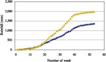
Figure 3. Cumulative average weekly values of precipitation for Korat and Nong Khai, representing the driest and wettest locations in N.E. Thailand, respectively
Crop simulated have characteristics of ‘lowland rice’ and of ‘bean crops’ in their development and growth parameters (Penning de Vries et al., 1989). Target yields are set by farming style and reflect variety choice and fertilizer level. Fish grow 10% per week if sufficient feed is supplied (related to ‘style’). Common market prices (2004) are used for the produce. Only gross income is computed.
Calibration. Since it is impossible to collect sufficient basic data for each case for which the model will be applied, it is good practice to collect data from a number of trials and to compare them with actual observations for the purpose of calibration. Much of this still needs to be done and ‘calibration’ is so far only done by ‘guestimation’; results should therefore be taken as indicative values only.
SIMILE allows inspection of the values of all model variables at any time interval in output tables or graphs. Export of these variables is possible for further analysis with other programs, such as MS-Excel. The set of macro’s for Scenario Analyses is called BoNam-SA.
Looking in great detail to individual variables is necessary when the model is build and tested. A comprehensive set of outputs could include weekly or monthly values of the soil relative water contents in the plots 3 and 4, levels of water stress in the crops, crop dry weights, and runoff between fields and from the farm, and the water level in the pond.
In the productive stage of modelling, however, one is interested in a few outputs only, such as the indicators of performance. We use four indicators of farm performance: (i) annual farm gross income (Baht yr-1) as it results from rice, vegetables and fish; (ii) number of weeks per year that a pond is dry as a measure of risk; (iii) the quantity of irrigation applied (m3 yr-1) that can be used to determine water use efficiency, and (iv) the quantity of runoff from the farm (m3 yr-1) to see the consequences of choices on neighbouring farms. In the next section, we provide examples of the first two indicators.
The question about the optimum size of the farm pond (question 1, Box 1) is relevant before a major investment of excavating a pond or constructing a reservoir and for detailing the conditions for a loan for this purpose. It can be answered by running the model for scenarios of relative pond sizes, and by inviting the farmer to select the answer that fits her/ him. For an illustration of the type of results provided, we ran the model for relative pond sizes from 0.0 to 0.3 (m2 pond surface m-2 farm) and for the four farm styles with otherwise the same input data and all management parameters set at default values. A first round of interactions with the FO Local Wisdom took place in Buriram (2004), and other rounds are planned.
The following graphs present three values for the indicator at each pond size. The middle one corresponds with the average level, the upper one with the level attained or exceeded in the best 25% of the years and the lower one with the level attained or not quite in the worst 25% of the years. The spread between the upper and lower values is a measure of the inter-annual variability in weather. Irregular patterns in the graphs are due to non-linear processes, such as failure or a second crop due to drought.
Results in Figure 4 for the indicator ‘farm income’ for the driest site (Korat) indicate that a pond size of 5-10% is optimal for the styles A-C, while ‘no pond’ is usually best for style D. There is no sharp optimum, and the value tends to be higher for the wetter years. Note also the difference in Y-axes: the styles B and C provide more income than style A and much more than D. The main reason why the income goes down at larger pond sizes is that the size of the vegetables plot, a major income earner, becomes small.
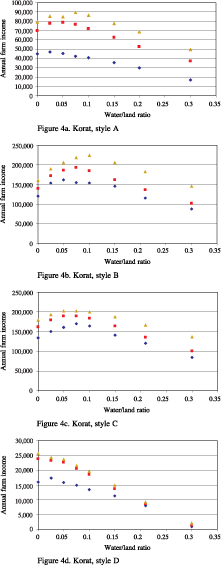
Figure 4 (a-d). The relation between pond size and average farm income in Korat under four farming styles
To illustrate the large difference between different parts of N.E. Thailand, we show in Figure 5 the indicator ‘number of dry weeks’, and give an indication of ‘risk’ related to climate. Selected are data from 2 locations (Korat, Ubon) and all for farming To demonstrate the value of the model for exploration of innovations, we reran the model for the same situations as in Figure 5, but reduced drainage from ponds to zero (as could be done with clay on the pond bottom, or with plastic sheets). The results are shown in Figure 6. The difference is not as large as might be expected because evaporation losses from the surface are as large as the (low) rate of drainage in Figure 5.
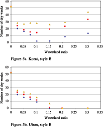
Figure 5 (a, b). The number of weeks that the pond is dry under farming style B in Korat and in Ubon
It is important to realize that in any situation the ‘optimum pond size’ is not the same for each of the four indicators. Moreover, the different styles, farmers give different weights to each of the indicators. As a result, determining ‘the’ optimum for a particular farmer cannot be done by reading only Figures 4, 5 or 6, and was suggested for brevity in the previous section. A more comprehensive set of graphs needs to be considered together in a multi-criteria analysis. How this can be done effectively and interactively for this model with Thai farm advisors has still to be established.
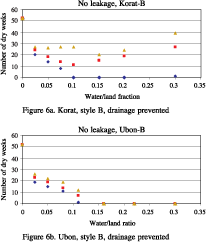
Figure 6 (a, b). The number of weeks that the pond is dry under farming style B but with sealed ponds to stop drainage
This sample of results demonstrates some of the capacities of the BoNam model and present only indicative values. Limited calibration and feedback, however, are still a handicap to the practical value of the results. On-farm observations and interaction sessions are planned for the near future.
Shape of the pond was not mentioned so far even though farmers are interested in this feature. The shape of the pond (oval, rectangular, multiple small ones) does not affect much the results of simulations and any particular choice won’t affect the results significantly. Practical advice, therefore, is to identify the shape(s) in agreement with landscape (lower parts of the farm and following the landscape). In low parts, upwelling of water from local acquifers could be very important. A factor farmers can influence is shading of the pond. This leads to a reduction of wind and hence of surface evaporation (but an increase of transpiration if trees provide shade) to reduce evaporation.
Local runon can be very significant. Yet, we observed on several occasions and different farms that farmers tend to overestimate the importance of rainfall in filling farm ponds and underestimate run-in; the quantities of drainage and upwelling are difficult to appreciate. A benefit of using the BoNam model can therefore be the refinement of the mental models FOs and farmers to in their daily operations with the farm water balance.
A model can also help to address consequences of variability and heterogeneity that otherwise can be difficult to judge. We avoided use of averaged rainfall data for simulation as Nonhebel (1994) found that use of such data may lead to overestimation of yields by 50% (unirrigated) to 15% (fully irrigated crops). However, there is still significant uncertainty in other important parameters, so that evaluation and calibration in the future needs more attention. Metselaar (1999) demonstrated clearly the importance of parameter inaccuracy in predictive modelling, and showed that calibration is indispensable before practical results can be obtained.
While it may be argued that the pnd on every farm is customized in size and shape, in practice this cannot be handled at a large scale by the contractors who build them. They provide only the standard size and shape, where farmer can only determine where on the farm and, within limits, the linear. On a 1 hectare farm, the LDD standard volume (fixed value of 1,260 m3) corresponds with a relative pond size of 4% (or about 15 × 25 m). Future scenario analysis should consider how to optimize for every growing season the use of the water in a pond of fixed size.
We thank the Farmer Organization ‘Local Wisdom’ for inspiration and advice, and a reviewer for valuable comments.
Annandale, J.G., Benade, N., Jovanovic N.Z., Steyn J.M. and du Sautoy N. 1999. Facilitating irrigation scheduling by means of the soil water balance model. WRC Report 753/1/99. Water Research Commission, Pretoria, S. Africa.
Antle, J.M. and Stoorvogel J. 2000. Integrating site-specific biophysical and economic models to assess trade-offs in sustainable land use and soil quality. www. tradeoffs.montana.edu/pdf/integrating.pdf.
Bepler, S. 2002. Consultancy report on Population and Community Development Association (PDA), IWMI-SEA, Bangkok, Thailand.
Bridges, M., Hannam I., Oldeman, R., Penning de Vries, F.W.T., Scherr S. and Sombanpanit S. (Eds.) 2001. Response to land degradation. Oxford, New Delhi, India and IBSRAM, Bangkok, Thailand.
Chamrusphant, V. 2001. The people of the Korat basin and their empowerment. 79-87 in: Natural Resource Management Issues in the Khorat Basin of N.E. Thailand: an overview. Kam, S.P., Hoanh, C.T., Trebuil G. and Hardy B. (Eds.). Limited Proceedings No. 7. IRRI, Philippines.
Chutikul, K. 2001. Roles and activities of institutions in regional development, with emphasis on agricultural development. 89-95 in: Natural Resource Management Issues in the Korat Basin of N.E. Thailand: an overview. Kam, S.P., Hoanh, C.T., Trebuil G. and Hardy B. (Eds.). Limited Proceedings No. 7. IRRI, Philippines.
Croke B.F., Ticehursta J.L., Letcher R.A., Newham L.T.H., Norton J.P. and Jakeman A.J. 2005. Integrated assessment of water resources: Australian Experiences. In: Integrated Assessment of Water Resources and Global Change: a north south analysis. E. Craswell, ed. Global Water System Project, University Bonn, Germany (in prep.).
Goto, J. and Koike, M. 1997. Ten farmer interview case study in Khon Kaen 1996. 210-212 in: JIRCAS publication, Bangkok, Thailand.
Heerden, P. van, 2004. PLANWAT. Manual for a computer simulation program for on farm water catchment and storage. Working Paper 82 with CD-ROM, IWMI, Sri Lanka.
Hungspreug, S., 2001. Water management in the Korat Basin, N.E. Thailand: policy, institutional, and management issues from the farm/villages to the region. 119-124 in: Natural Resource Management Issues in the Korat Basin of N.E. Thailand: an overview. Kam, S.P., Hoanh, C.T., Trebuil G. and Hardy B. (Eds.). Limited Proceedings No. 7. IRRI, Philippines.
Khao Hin Sorn, 1999. Annual Report 1998. Land Development Department, Bangkok.
Kono, Y. 2001. Modeling agricultural productivity in N.E. Thailand: background, project outline and prospects. 39-48 in: Natural Resource Management Issues in the Korat Basin of N.E. Thailand: an overview. Kam, S.P., Hoanh, C.T., Trebuil G. and Hardy B. (Eds.). Limited Proceedings No. 7. IRRI, Philippines.
LDD, 2005. Royal new Theory: Agricultural Land management. Land Development Department, Bangkok, http://www.ldd.go.th/EFiles_html/main% 20page/Ea0400.htm
Lisson, S.N., Brennan L.E., Bristow K.L., Keating B.A. and Hughes D.A. 2003. DAM EA$Y-software for assessing the costs and benefits of on-farm water storage based prduction systems. Agricultural Systems 76, 19-38.
Limpinutana, V. , 2001. Physical factors related to agricultural potential and limitations in N.E.
Thailand. 3-17 in: Natural Resource Management Issues in the Korat Basin of N.E. Thailand: an overview. Kam, S.P., Hoanh, C.T., Trebuil G. and Hardy B. (Eds.). Limited Proceedings No. 7. IRRI, Philippines.
Metselaar, K., 1999. Auditing of dynamic simulation models. PhD thesis Wageningen University, Netherlands.
Muetzelfeldt, R. and Massheder, J. 2003. The Simile visual modelling environment. Europ. J. Agronomy, 18, 345-358.
Nonhebel, S. 1994. The effects of use of average instead of daily weather data in crop growth simulation models. Agricultural Systems, 44, 377-396.
Penning de Vries, F.W.T., 2006. The farm level model to simulate multiple uses and multiple sources of water BoNam. Manual. (in prep.)
Penning de Vries, F.W.T., Jansen D.M., Ten Berge H.F.M. and Van Laar H.H., 1989. Simulation of several annual crops. Simulation Monographs PUDOC, Wageningen, Netherlands.
RID, 1994. Crop Water Requirements. Royal Irrigation Department, Bangkok, Thailand.
Ruaysoongnern, Sawaeng and Penning de Vries F.W.T. 2005. Development of Learning Alliances for the scaling up of multi-purpose farm ponds in a semi-arid region of the Mekong basin. In: Learning Alliance Conference, IRC, Delft, Netherlands (in prep.).
Ruaysoongnern, Sawaeng and Suphanchaimart N. 2001. Land use patterns and agricultural production systems with emphasis on changes driven by economic forces and market integration. 67-77 in: Natural Resource Management Issues in the Korat Basin of N.E. Thailand: an overview. Kam, S.P., Hoanh, C.T., Trebuil G. and Hardy B. (Eds.). Limited Proceedings No. 7. IRRI, Philippines.
Srisuk, K., Sriboonlue V., Buaphan C. and Hovijitra C., 2001. The potential of water resources in the Korat basin, N.E. Thailand. 99-113 in: Natural Resource Management Issues in the Korat Basin of N.E. Thailand: an overview. Kam, S.P., Hoanh, C.T., Trebuil G. and Hardy B. (Eds.). Limited Proceedings No. 7. IRRI, Philippines.
Tipraqsa, P., 2005. Rehabilitation of degraded marginal land by smallholder farmers in N.E. Thailand. Case study of Huai Nong Ian catchments, Waeng Yai and Chonnabot districts, Khon Kaen Province. PhD thesis university Bonn, Germany (in press).
Wolf., J., Ponsioen T. and Hengsdijk H. 2004. TechnoGIN-3: a generic tool for analysing cropping systems: application of the prototype for W. African conditions within the VINVL project. Research Report 2004-03, Alterra, Wageningen, Netherlands.
1 Monsoon Asia Integrated Regional Studies, Institute of Atmospheric Physics, Chinese Academy of Sciences, Beijing ([email protected]), formerly: International Water Management Institute, Pretoria, South Africa.
2 Khon Kaen University, Khon Kaen, Thailand ([email protected])
3 Land Development Department, Bangkok, Thailand ([email protected])
![]()
![]()
![]()