![]()
![]()
![]()
The total number of dams resulting from the merger equalled 3843, of which 3397 have surface areas, 3713 have capacity data and 3767 have co-ordinates (cf. table 1). Data from AGLW/FAO did not have any surface areas. No capacity figures were available from the DEAT publication because this concerned natural water bodies. More than 93% of all records were extracted from the Dam Safety Record data-set which were in some cases supplemented with information from the Institute for Water Quality Studies.
Table 1: Number of entries from each information source for 3 important data fields
| Main Sources | No. of entries with known co-ordinates | No. of entries with known surface areas | No. of entries with known capacities | Total No.of entries |
| AGLW/FAO Rome | 25 | 0 | 21 | 28 |
| Dam Safety Office (DWAF) | 3518 | 3343 | 3546 | 3583 |
| Hydrographical Survey Service (DWAF) | 142 | 1 | 125 | 148 |
| Hydrology Service (DWAF) | 44 | 21 | 21 | 45 |
| Dept. Environ. Affairs & Tourism | 38 | 32 | 0 | 39 |
| Total | 3767 | 3397 | 3713 | 3843 |
All co-ordinates from the DSO, Hydrographical Survey Service and AGLW/FAO Rome were obtained in degrees and minutes only (no seconds). As a result, accuracy may become a problem at a better scale. Where possible, as in the case of data from the Institute of Water Quality Studies, water bodies were linked to a database with more precise coordinates which were included in the database.
Although data from the WR90 were used for cross-checking (specifically with regard to the hydrozones), none of the dams from the WR90 CD were integrated in the database. This is due to the fact that it was not possible to get details on the source of surface area and capacity data which looked unrealistic.
A complete list of the data fields and summary statistics is given in annex III and available on disk (za_swb.dbf)
Table 2: Number of SWBs within each drainage region
| Drainage Region | Number with co-ordinates | Total |
| A | 237 | 241 |
| B | 251 | 260 |
| C | 377 | 383 |
| D | 322 | 327 |
| E | 211 | 215 |
| F | 1 | 1 |
| G | 439 | 443 |
| H | 277 | 282 |
| J | 115 | 118 |
| K | 90 | 92 |
| L | 104 | 104 |
| M | 6 | 6 |
| N | 41 | 41 |
| P | 56 | 56 |
| Q | 97 | 100 |
| R | 52 | 55 |
| S | 63 | 63 |
| T | 118 | 123 |
| U | 332 | 342 |
| V | 227 | 231 |
| W | 139 | 143 |
| X | 159 | 161 |
A point distribution file (za_swb.bna) was created in atlas GIS format based on the coordinates in the database. The point distribution file holds two identifiers for each point: the unique identifier in the database (SADC_ID) and the name of the water body. The co-ordinate file was overlayed with the drainage regions of South Africa using a mapping programme (Mapviewer), to produce a distribution map of SWBs in South Africa (figure 2).
The meta-database holds information on the source of each field and each record in the main database. The main meta-database (za_sourc.dbf) is basically a copy of the SWB database with data replaced by a source identifier. This source identifier can be linked to the source code database (za_code.dbf) which holds the exact information on each source (cf. annex V). The source identifying numbers are not logically sequenced as they were derived from the larger source file which was created for the complete SADC SWB database holding almost 20000 records.
Following files comprise the complete SWB dataset:
| za_swb.dbf | main database with 3848 SWB records in South Africa |
| za_sourc.dbf | main source file comprising source codes for each entry |
| za_code.dbf | meta-database source code file (cf. annex V) |
| za_swb.bna | point atlas GIS file of SWBs in South Africa with co-ordinates |
Characteristics of data fields and summary statistics on za_swb.dbf and za_sourc.dbf are provided in annex III and IV. The files can be linked in a regular database package using the SADC identifier so that a source code appears behind every entry. It follows that the coding file should be linked to define the numeric source code (cf. figure 1).
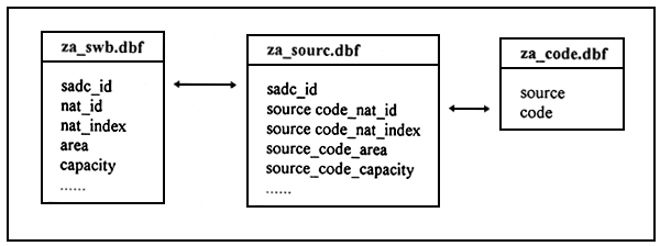
Figure 1: Linking of the database files
All corrections and modifications that were made by ALCOM to the original data are documented in annex and available in the following files:
| annex l.dbf | list of SWBs with co-ordinates interchanged by ALCOM (Annex I) |
| annex2.dbf | list of SWBs with possible wrong co-ordinates (Annex II) |
| za_check.dbf | list of SWBs with duplicate set of coordinates |
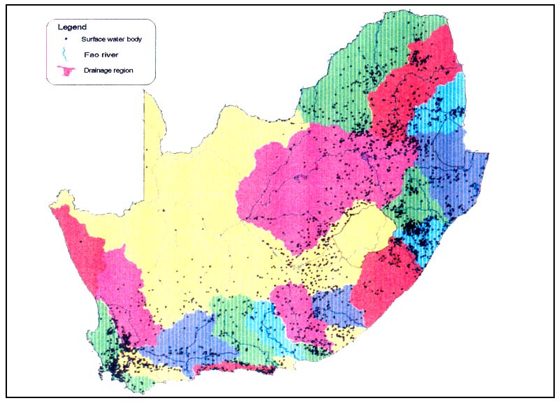
Figure 2: Distribution of Surface Water Bodies in South Africa
![]()
![]()
![]()