![]()
![]()
![]()
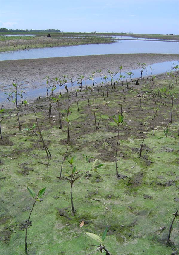
Returning to the original question: Was the tragedy caused by the 26 December 2004 Indian Ocean tsunami, and the destruction and death cause by tsunamis in general, preventable? This publication partly answers that question by evaluating the role played by coastal forests in the mitigation of tsunami damage. Evidence from post-tsunami surveys, field research and model simulations strongly support the notion that coastal forests can provide significant mitigation of tsunamis and storm waves. All forest types, with the exception of altered forests, demonstrate the ability to mitigate tsunami energy and force, reduce flow depth and velocity, and limit inundation area. These forests include mangroves, beach forests and plantations. Healthy, undegraded natural forests offer good protection to coastal areas, but plantations of closely-spaced trees with low, widely-branching canopies or significant ground vegetation can also provide equally good protection. Altered forests found around homesteads, hotel resorts and other development areas, on the other hand, are generally too widely-spaced, lack ground vegetation, and have introduced trees species not adapted to coastal wind and wave forces, and so are structurally weaker.
Notwithstanding the positive role many coastal forests have played, other forests proved to be ineffective against the tsunami waves. Evidence shows that coastal forests failed where waves were very large; forest width was limited; or trees were widely spaced, of small diameter or without branches near ground level. Any forest type could be susceptible, though degraded natural forests, altered forests and plantations are more likely to be deficient in one respect or another.
Besides failing to protect a coastal area, forests can become a liability under some circumstances. First, if a forest is levelled by a tsunami, the broken material will become floating debris with increased destructive force. Greater forest width can overcome the problem, but for very large tsunami such great widths may not be feasible. Small diameter trees associated with young plantations, and some mangroves are susceptible to uprooting or breakage along the trunk, but branches of larger trees are also at risk of breaking. A weak soil substrate also increases chances of uprooting. A second caveat relates to the gaps found in forest barrier created by homesteads, roads, beach access and other development. Unless very wide, these gaps increase flow velocity and force in and immediately behind the gap. Coastal planning therefore needs to recognize this hazard and minimize the creation of gaps, avoid vulnerable development within gaps, and make other contingencies as necessary.
While it is not feasible to establish a coastal forest “biosheild”– unbroken and of sufficient width and density – along the entire length of every coastline prone to tsunami, they can play a major role in protecting coastlines in Asia and the Pacific. Given their low cost of establishment and maintenance relative to other protective structures such as rock and cement seawalls and other ‘hard’ barriers, and their potential for generating other economic and environmental benefits, these ‘soft’ structures may justifiably become more widely utilized.
Extensive control forest in Ibaragi Prefecture on the Pacific coast of Japan. Such forests are designed to mitigate coastal hazards (strong coastal winds and blown sands, storm surge and tsunamis) and protect inland agriculture and habitation.
|
Wave height (m) |
Water |
Protect or Failed |
Near- or Far-field |
Forest type |
Width (m); spacing (m) |
Special circumstances |
Country, location |
Source |
|
15-30 |
fail |
near |
Beach |
~400 + |
Casuarina and other trees up to 50 cm dia snapped or uprooted; 5m sand dunes also levelled |
Lhoknga, West Aceh, Indonesia |
Latief and Hadi, 2006 | |
|
10 |
fail |
near |
Plantation |
~10 m in 1 or 2 rows |
Casuarina shelterbelt 50 cm dia withstood but spacing too wide; 10 cm dia broken |
Phang Nga, Thailand |
Tanaka et al, 2007 | |
|
~10+ |
10 (6) |
protect |
near |
Plantation |
250-300 |
Cashew plantation, fronted by 5-m wide casuarina shelterbelt. |
Ranong, Thailand |
Tanaka et al, 2007 |
|
8 |
~5 |
protect |
near |
Mangrove |
> 50 |
First 50 m broken above aerial stilt roots; mitigation by remaining mangrove |
Phang Nga, Thailand |
Tanaka et al, 2007 |
|
7-12 |
fail |
near |
Mangrove |
10 ha; 150 stems/m2 |
Dense, healthy mangroves snapped or uprooted |
near Banda Aceh, Indonesia |
Wetlands International, 2005 | |
|
7-9 |
4-6 |
protect |
far |
Mangrove |
200 |
Uprooted and collapsed, but enough energy absorbed that damage to village reduced |
near Hambantota, Sri Lanka |
Wetlands International, 2005, Ranasinghe, 2006 |
|
7 |
protect* |
far |
Mangrove |
~5-6 m |
* River bank vegetation on estuary reduced water depth |
Yan Oya River, Sri Lanka |
Yasuda et al., 2006 | |
|
6-9 |
fail |
far |
Plantation |
10-15 |
Casaurina shelterbelt badly damaged and uprooted in sections; tree diameters not documented |
Batticaloa, Sri Lanka |
IUCN 2005b | |
|
6-7 |
protect |
near |
Beach |
40 |
Near-field 2006 West Java tsunami |
Cikalong, West Java |
Latief and Hadi, 2006 | |
|
6 |
~4.5-5 |
protect |
far |
Beach |
155; dense |
Mostly due to pandanus (10m); also coconut, mangrove |
near Rekawa, Sri Lanka |
Tanaka et al, 2007 |
|
5.2-6.8 |
protect* |
near |
Altered |
100 |
* Protection by coconut grove from erosion |
Phang Nga, Thailand |
Hiraishi, 2006 | |
|
5-6 |
3 |
protect |
far |
Altered |
> 100; 3 |
Houses within first 100 m damaged; relatively dense coconut |
Kalutara, Sri Lanka |
Tanaka et al, 2007 |
|
5.0-5.5 |
fail |
far |
Beach |
200 |
Shrubs and small diameter trees (7-10 cm dia) broken and swept away |
Yala, Sri Lanka |
Tanaka et al, 2007 | |
|
5 |
3 |
fail |
far |
Altered |
500; 4-40 |
Widely-spaced coconut with habitation within |
Hikkaduwa, Sri Lanka |
Tanaka et al, 2007 |
|
4.5-5.5 |
protect |
far |
Beach |
100; dense |
Mostly due to thick pandanus; also coconut |
near Galle, Sri Lanka |
Ranasinghe, 2006 | |
|
4.5 |
protect |
far |
Plantation |
200; 2.5 |
Large damage reduction by 35-yr old casuarina (10-20 cm dia) shelterbelt |
Tamil Nadu, India |
Danielsen et al., 2005 | |
|
~4-7 |
3-5 |
protect |
both |
Plantation |
20-26; 1.6 |
Japanese pine, with undergrowth |
45 observations throughout Japan |
Shuto, 1987 |
|
4-5 |
protect |
near |
Mangrove |
50; dense |
Inundation distance was 400 meters at the sandy beach |
Ranong, Thailand |
Siripong, 2006 | |
|
4-5 |
protect |
far |
Mangrove |
10-15 ha |
Distance from sea and elevation also contributed |
Tamil Nadu, India |
Kathiresan and Rajendran, 2005 | |
|
~4 |
2.5 |
fail |
far |
Altered |
54; 7 |
Widely-spaced coconut grove |
Oluvil, Sri Lanka |
Tanaka et al, 2007 |
|
3-7 |
protect* |
near |
Mangrove |
~400; dense |
* Reduction of beach erosion in mangrove area |
Nicobar Islands |
Ramanamurthy et al., 2005 | |
|
3 |
fail |
near |
Beach |
200 |
Mature casuarina (50-100 cm dia) no lower branches |
Ranong, Thailand |
Tanaka et al, 2007 | |
|
2-3 |
~1-2 |
protect |
far |
Altered |
~200 + |
Relatively dense planted coconut, beach forest and horticultural groves |
Kerala, India |
Chadha et al., 2005 |
|
1.5-2.5 |
~1-2 |
protect |
far |
Beach |
15-20; dense |
Shrubs, small trees; Low, mostly non-breaking waves |
Maldives |
UNEP 2005 |
Table1: Collated information on tsunami damage in relation to wave and forest characteristics for the Indian and Pacific Oceans
![]()
![]()
![]()