![]()
![]()
![]()
John A. Howard
and
Jean-Paul LanlyJohn A. Howard, a forester, is the senior officer of FAO's Remote Sensing Unit.
Jean-Paul Lanly is the FAO Forestry Department's officer responsible for forest surveys.To many, remote sensing means satellites and a sophisticated, expensive technology. In fact, remote sensing for forestry is still being carried out for the most part with conventional cameras, films, aircraft and interpretative equipment adapted or developed for this work. The authors discuss these remote sensing photographic techniques as used in tropical forest surveys.
Tropical forests, in the broad sense - woody vegetation types ranging from open savanna woodland to closed high forest - cover a total area of approximately 19 million square kilometres, or 14% of the world's area, and slightly less than half of the world's forested area. They are nearly all located in the less developed parts of the world, and for the countries concerned they represent an important resource, from both the production and the conservation points of view.
As is widely recognized, the tropical forest cover is being rapidly degraded and/or depleted under the combined effects of shifting cultivation, overgrazing and destructive logging. Several comparative analyses have provided significant figures on the depletion of tropical forests in different parts of the world. For instance, the total forest cover of the Ivory Coast was reduced by 30% between 1956 and 1966 (Lanly, 1969), and 40% reduction occurred in the region of the Magdalena and Sinu valleys in Colombia between 1956 and 1965 (FAO, 1970).
In view of their economic and environmental importance, the tropical forests need to be continually monitored within each country at the various levels of planning, control and management, and also on a regional and worldwide basis, to alert the international community to the detrimental effects of forest exploitation and the measures to be taken.
As commonly applied in forestry, the term "remote sensing" relates to the collection from a space platform of data about objects on or near the earth's surface (Parker, 1962), but it is increasingly extended to include the analyses of the data collected. The space platform is usually a fixed wing aircraft, occasionally a helicopter, now sometimes a satellite and experimentally a rocket (e.g., Skylark - see Ridgway and Hardy, 1973).
In the past, the data-collecting device has been an aerial camera but mechanical scanners are now being increasingly used to obtain thermal imagery, radar imagery (SLAR imagery), and satellite imagery. Nonimaging aerial remote sensing is important in geophysical surveys; however, with a few experimental exceptions such as radar altimetry (Sayn-Wittgenstein, 1970) and laser beam profiling, only image-producing techniques are used in forestry.
This article deals with the use of photographic techniques as a part of remote sensing in the field of tropical forest surveys. By "photographic techniques" is meant those in which a single camera with one or more lenses or a multicamera system is used for sensing in the visible or near infrared parts of the spectrum, with one or more film-filter combinations, and with any type of platform.
Vertical aerial photography was first used in a tropical forest survey in Burma in the early 1920s (Blandford, 1924; Howard, 1970a). By the 1930s aerial photographs had been used in forest resource surveys as far apart as Zambia (Bourne, 1931) and Papua - New Guinea (Payers, 1971). In the Burma survey Irrawaddy delta), several forest types were identified from the photographs at a scale of 1:20000.
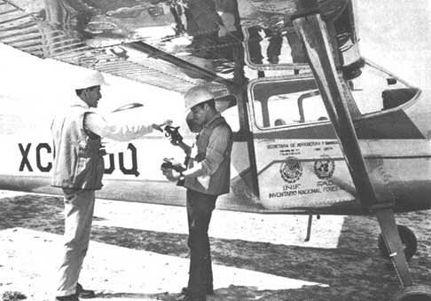
MEXICAN FORESTERS ENGAGED IN AERIAL SURVEY WORK Rockets are not absolutely essential
These early surveys using aerial photographs helped to establish an approach to tropical forest inventory similar to that of forest surveys in temperate regions, and which has continued up to the present time. That is the use of black-and-white panchromatic photography with a minus-blue filter (yellow filter), a medium focal length lens (i.e., 15.2 or 20.5 cm) and a minimum sun-angle of about 30". However, the small photographic format of the early aerial photography (4 X 5 inches) was replaced first by a 7 X 9-inch format, occasionally later by a 19 X 19-cm format, and finally by a 23-cm format (i.e., a 9-inch format).
After the second world war there was an immense surge forward in the taking of aerial photographs for topographic and planimetric mapping in the tropical countries. As these photographs were usually taken at a fairly small scale, the forest photointerpreter had, and usually still has, to work at scales between 1:30000 and 1:60000, and occasionally smaller. As examples of very small-scale aerial photographs in tropical countries, one can quote 1:80000 in the northern part of the Ivory Coast, 1:84000 in Papua-New Guinea, 1:92000 in some parts of the Sahelian zone, and recently 1:120000 in Kenya.
Somewhat surprisingly, small-scale photographs are not as restrictive as might be expected, because the information required from photographs of tropical forest areas is usually of a more general type than that required from forest surveys in many temperate countries. In tropical inventory, photointerpretation is often confined to the delineation of forested lands, broad forest types, and dominant structural units of vegetation (i.e., plant formations/subformations). This type of information facilitates the exclusion of areas in which marketable species do not occur; and, more generally, serves for a stratification ahead of ground sampling - thus increasing sampling efficiency - either by reducing the sampling error for an equal sampling intensity or by reducing the sampling intensity required for the same level of sampling error. These delineations are often made on or transferred to mosaics and maps compiled from the same photographs. Sometimes the only practicable forest stratification is one based on land units (Howard, 1970b). Also, the aerial photographs, through the use of measurements of slope and other terrain characteristics, help in the stratification of forested areas as regards accessibility, as in the FAO surveys in Madagascar (FAO, 1971b) and Gabon (FAO, 1973). In general, how ever, accessibility mapping has been neglected for forest inventory.
The above applications of photointerpretation refer to forest characteristics and classification. When the units for interpretation are the trees themselves, aerial photographs have proved much less useful in the tropics than in temperate zones, where, as in North America for instance, they have been mainly used at scales between 1:10000 and 1:15840 (i.e., 4 inches = 1 mile) to obtain information on individual tree and stand heights, number of trees per unit area, crown characteristics, crown widths and stand volumes per species
The identification of the species of individual trees from small- and medium-scale photographs in the tropics has been achieved in relatively few cases. There are several major reasons for this, among which: the many tree species occurring in tropical forests - even tropical woodland may contain over 40 tree species per square kilometre (Howard, 1959); the very variable phonology in space and time; and the poorly defined vertical layering (Rollet, 1974). Two or more tree crowns may appear as a single crown on the photographic image, and large crowns in the upper storey may be interpreted as two or more trees. However, at a scale of 1:5000, crown counts on panchromatic black-and-white photographs over a tract of rain forest in Surinam were reported: "to offer possibilities for assessments of the timber potential" (Versteegh, 1974).
Occasionally a species or genera is distinctive, such as Dipterocarpus spp. in Thailand and Doona congestiflora in Sri Lanka. Counts of Limba trees (Terminalia superba) carried out on 1:50000 panchromatic black-and-white aerial photographs in the southern part of the Congo, with errors (but not biases) less than ± 25%, allowed an approximate valuation of the stands with regard to this most important species (Centre technique forestier tropical, 1965). Usually, however, photo typing of a single species within mature forests of the tropics relies on the gregarious nature of the species, often linked with edaphic conditions: mangroves, littoral stands of Campnosperma panamensis, riparian forests of Guibourtia demeusei, Hura crepitans, Mora excelsa and Prioria copaifera, and pure stands of Leguminosae (e.g., Gilbertiodendron dewevrei and Monopetalanthus spp.).
As a plant subformation is a structural unit of vegetation and not a floristic unit (e.g., association), its spectral radiance/albedo is often distinctive, which results in a characteristics photographic relative grey scale value. Thus, sometimes, a species can be singled out through recognition of the (plant) subformation which contains it. The importance of relative grey scale values (Stellingwerf, 1966; Howard, 1970a) helps to explain why in tropical forest photointerpretation a wide range of photographic scales is acceptable; and, although requiring greater photointerpretative skill, as much usable forest information may be obtained from photographs at a scale of 1:80000 or smaller than from those at much larger scales. Infrared black-and-white photography has been used to advantage on several occasions in tropical Africa, since better haze penetration occurs at the longer wavelengths of infrared radiation reflected from the earth's surface. Contrast and sharpness are often much better and interpretation may be more reliable. Moreover, the boundaries of exposed moist soil and water surfaces are better defined. On several occasions infrared photographs have proved more useful than panchromatic photography in the identification of tropical species; for example Musanga cecropioides in the Central African Republic (Lanly, 1972), and Virola surinamensis in Guyana (FAO, 1971a).
Suprisingly little has been published on the role and application of aerial colour photography in tropical forestry (i.e., normal colour and infrared/false-colour photography). On first considerations, the taking of colour aerial photographs may appear to be much more expensive than black-and-white photography. Colour film is more costly (cost ratio possibly 1:5), more exacting to use (fewer flying hours per day and flying days per year), more expensive to process (cost ratio possibly 1:4), wastage is greater and the risk of damage to processed film by fungal attack in the tropics is considerable. However, to base a planning decision on these factors alone would be misleading, since the largest fixed cost factor, the taking of the photographs, remains approximately the same. For a large area having known favourable weather conditions, and readily accessible to contractors, the cost ratio of normal colour to black-and-white photography would probably not exceed 5:4 - the cost of preparing maps, which is relatively expensive, is additional. If, as often occurs, the colour photographs provide more usable information to the photointerpreter, or improve the efficiency of the forest resources survey, then the cost/benefit of colour vis-á-vis black-and-white can be expected to increase.
The main contribution of single camera colour photography to tropical forestry in recent years has been to improve the mapping accuracy of forest stand boundaries and to improve forest-type mapping, including the better separation of the understorey and age/height classes, and occasionally an improvement in the identification of tree species, especially when used in combination with other films (Stellingwerf, 1971). However, colour photography is still used considerably less in the tropics than in temperate regions and corresponding research is even more reduced.
Recently there have been several at tempts to use very large-scale colour panchromatic photography (e.g., 1:5000) to improve the identification of tree species. Experiences in Surinam (de Milde and Sayn-Wittgenstein, 1973) and in Cameroon and Gabon (Clement and Guellec, 1974) were mainly based on the stereoscopic interpretation of forest species from normal colour photographs. For example, 73% of the okoumés (Aukoumea kleineana) examined in Gabon had a characteristic image which was identifiable on the photographs.
Large-scale colour photography is also well suited, as in temperate regions, to the monitoring of insects and diseases, and fire-damaged forest stands (Wolff, 1966; Hildebrandt and Kenneweg, 1970). Black-and-white and colour 70-mm and 35-mm aerial photographs have also proved in east Africa to be valuable in wildlife surveys (Howard, 1970a).
Colour photography in the form of strips to supplement existing smaller scale photography for topographic and planimetric mapping may prove a useful development.
Multiband photography implies the use of two or more simultaneously operated cameras, or the use of a multilens camera with selected filters (usually narrow-band) and black-and-white (usually infrared). For convenience, the latter type of aerial photography will be termed multispectral.
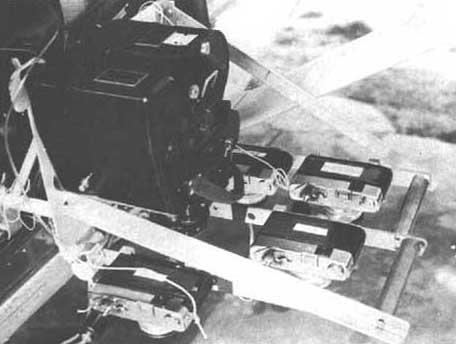
Some years ago, as in the French national forest inventory, multiband photography consisted usually of simultaneous black-and-white panchromatic photography (with a minus-blue filter) and black-and-white infrared photography (with a deep red/black filter). The Institut Géographique. National has also used this two-camera technique in Africa since 1960 (Stellingwerf, 1971). However, there is a tendency nowadays for these film-filter combinations to be replaced by or used in combination with simultaneous normal and infrared colour photography. Sometimes, a cluster of four 70-mm format or 35-mm format cameras are used. In a study carried out in Surinam by the International Institute for Aerial Survey and Earth Sciences' four 70-mm cameras were used. Experimentally, in North America, clusters of up to nine 70-mm cameras have been employed (Lauer, 1971).
Whereas multiband colour photography is based on the subtractive theory of colour and uses three-layer film, multispectral colour photography relies on single-layer black-and-white film and uses an additive colour viewer (in the laboratory) to combine three or four film exposures taken simultaneously into a single colour scene. Despite the disadvantage of a small film format, multispectral photography is potentially useful to foresters, since it is selective by recording in key parts of the solar spectrum (e.g. for disease detection). Several different types of additive colour viewers are marketed, principally for use with ERTS (Earth Resources Technological Satellite) imagery; and vary in price up to about US$30000. Although multispectral aerial photographs have been taken of tropical forested areas, there are no known published results relating to tropical forest resources.
Nearly all aerial photographs have been taken at flying heights of less than 9400 metres (i.e., within the troposphere) to provide photographs at scales larger than 1:85000. Recently, pressurized aircraft have been used for nonmilitary photography at altitudes up to about 20000 metres, providing imagery at scales of 1:120000 or smaller, and this type of photography may be expected to increase if regional and national land-use and land resource surveys are needed with a photographic resolution of 3 to 5 metres, which is considerably superior to the resolution of ERTS-1 imagery. There remains, however, a major attitudinal difference between high altitude aerial photography and outer space photography Skylab imagery, for example, was taken at an altitude of 660 kilometres.
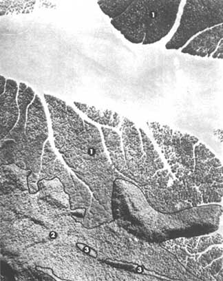
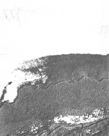
Outer space photography (Gemini-4, Mercury, Skylab, Skylark) like ERTS-1 imagery, provides a synoptic view of an extensive area of the earth's surface. A single Skylab 70-mm colour transparency covers a ground area of about 26500 square kilometres. Thus, the forester is able to observe major geological or geomorphic features influencing the forests of which he was not previously aware, and this, in turn, may influence his approach to forest resource inventory and regional and national forest management. Considerable information is available on drainage patterns and drainage densities. Conifers can be separated from hardwoods and often these in turn can be distinguished from "mixed" forest, regeneration, bare land, other plant formations (shrubland, grassland) and some other plant subformations (closed versus open woodland). On high quality Skylab colour transparencies, the photographic resolution of some ground objects has been observed as about 10 metres, which is indicative of the importance of space imagery in the future. Unfortunately, unlike ERTS imagery, present space photography covers but a small part of the earth's surface.
As pointed out earlier, the forester often has to work with photographs taken for purposes other than a forest resources survey. These photographs, frequently at a small scale and sometimes outdated, may not contain all classes of forest information or the detailed data needed for the survey; the deficiency is largely overcome by additional field sampling, which is usually expensive. Alternatively, the deficiency may be overcome by further aerial photography of selected ground areas. However, this second approach using supplementary photography has been neglected by foresters.
Several publications (e.g., Langley, 1969) advocate the use of supplementary photography in combination with multistage sampling from very small-scale photographs and/or satellite imagery. Supplementary large-scale aerial photography from light aircraft is taken of widely spaced strips (vertical strip photography) or of scattered small ground areas (vertical or oblique pin-point photography). Uses include updating of information on the forest cover and shifting cultivation as recorded on old photographs, improved identification of tree and shrub species, progress of forest disease and insect damage, and rangeland information on wildlife and domestic stock.
BLANDFORD, H.R. 1924, The aero-photo survey and mapping of the Irrawaddy delta. Indian Forester, 50:605-16.
BOURNE, R. 1931, Regional survey and its relation to stock-taking of the agricultural and forest resources of the British Empire. Oxford Forestry Memoir No. 13.
CENTRE TECHNIQUE FORESTIER TROPICAL. 1965, Quinze ans de travaux et de recherches dans les pays du Niar - 1949-1964. Synthèse des études, recherches et travaux en matière forestière dans les pays du Niari au Congo Brazzaville. Nogent-sur-Marne.
CLEMENT, J. & GUELLEC, J. 1974, Utilisation des photographies aériennes au 1/5000 en couleur pour la détection de l'Okoumé dans la forêt dense du Gabon. Bois et forêts des tropiques, No. 153.
DE MILDE, R. & SAYN-WITTGENSTEIN, L. 1973, An experiment in the identification of tropical tree species on aerial photographs. Proceedings Symposium IUFRO Subject Croup S 6.05, Remote Sensing, including Aerial Photography, Freiburg, 17-21 September 1973.
FAO 1970, Estudio de preinversión para el desarrollo forestal en los valles del Magdalena y del Sinu, Colombia. Inventario forestal, basado en el labor de Nikolaus Henning. Rome. FO:SF/COL 14. Informe Técnico 14.
FAO 1971a, Forest Industries Development Survey, Guyana. Inventory of a selected area in the Northwest District. Appendix 12. Based on the work of R. de Milde and D. de Groot. FO:SF/GUY 9. Technical Report No. 10.
FAO. 1971b, Inventaire et mise en valeur de certains périmètres forestiers, Madagascar. Carte pour l'évaluation de l'exploitabilité des forêts. Rome.
FAO 1973, Développement forestier, Gabon. Etude et classification des conditions de terrain pour l'exploitation forestière, par le Centre technique forestier tropical. FO:SF:GAB 68/506. Document de travail No. 7
HILDEBRANDT G.L. & KENNEWEG, H. 1970, The truth about false colour film. A German view. Photogramm. Rec., 6:448-451.
HOWARD, J.A. 1959, The classification of woodland in Western Tanganyika for type mapping from aerial photographs. Emp. for. Rev., 38:348-364.
HOWARD, J.A. 1970a, Aerial photo-ecology. London, Faber and Faber: New York, American Elsevier. 325 p.
HOWARD, J.A. 1970b, Multiband concepts of forest land units. Proceedings, 3rd International Symposium on Photo-interpretation, Dresden, p. 281 -316.
LANGLEY, R.G. 1969, New multistage sampling techniques using space and aircraft imagery for forest inventory. Proceedings, 6th International Symposium on Remote Sensing of Environment, University of Michigan, Ann Arbor, 2: 1179-1192.
LANLY, J.P. 1969, Regression de la forêt dense en Côte d'Ivoire. Bois et forêts des tropiques, No. 127.
LANLY, J.P. 1972, L'utilisation des photographies aériennes et des cartes pour l'évaluation des ressources forestières. A Application au cas de l'Afrique tropicale francophone. Document, Third Regional Cartographic Conference for Africa. FO:MISC/72/20.
LAUER, D.T. 1971, Multiband photography for forestry purposes. In Application of remote sensors in forestry, ed. by G.L. Hildebrandt, p. 21-36. Gainesville, Fla., International Union of Forestry Research Organizations.
ORR. D.G. 1968, Multiband colour photography. In Manual of colour aerial photography, p. 441-471. Falls Church, Va., American Society of Photogrammetry.
PARKER, D. 1962, Some basic considerations to the problem of remote sensing. Proceedings, First Symposium on Remote Sensing of Environment, University of Michigan, Ann Arbor, p. 1-5.
PAYENS, J. 1971, Personal communication. (Quoted in An historical outline of natural resource photo-interpretation in Australia, by J.A. Howard.) Revue Photointerpretation, 1971 (4).
RIDGWAY, R.B. & HARDY, J.R. 1973, Skylark over Woomera. Geogrl Mag., 289-297.
ROLLET, B. 1974, L'architecture des forêts denses humides sempervirentes de plaine. Nogent-sur-Marne, Centre technique forestier tropical.
SAYN-WITTGENSTEIN, L. 1970, Large-scale aerial photography and radar altimetry. In Application of remote sensors in forestry, ed. by G.L. Hildebrandt, p. 99-107. Gainesville, Fla., International Union of Forestry Research Organizations.
STELLINGWERF, D.A. 1966, Interpretation of tree species and mixtures on aerial photographs. Commission VII, International Symposium on Photo-interpretation, Paris.
STELLINGWERF, D.A. 1971, Aspects of the use of aerial remote sensors in tropical forestry. In Application of remote sensors in forestry, ed. by G.L. Hildebrandt, p. 89-98. Gainesville, Fla., International Union of Forestry Research Organizations.
VERSTEEGH P.J.D. 1974, Assessment of volume characteristics of tropical rain forests on large scale aerial photographs. ITC Journal, 1974(3):330-341.
WOLFF, G. 1966, Schwarz-weisse und falschfarbige Lufthilder als diagnostische Hilfsmittel für operative Arbeiten im Forstschutz. Commision VII, International Symposium on Photo-interpretation, Paris.
![]()
![]()
![]()