


WISDOM is a spatially-explicit method oriented to support strategic wood energy planning and policy formulation, through the integration and analysis of existing woodfuels demand and supply related information and indicators. Rather than absolute and quantitative data, WISDOM is meant to provide relative/qualitative values such as risk zoning or criticality ranking, highlighting, at the highest possible spatial detail, the areas deserving attention and, if needed, additional data collection. In other words, WISDOM serves as an ASSESSING and STRATEGIC PLANNING tool to identify priority places for action.
WISDOM is based on: a) the use of geo-referenced socio-demographic and natural resource databases integrated within a geographical information system; b) a minimum spatial unit of analysis at sub-national level; c) a modular, open, and adaptable framework which integrates information of relevance to wood energy from multiple sources; and d) a comprehensive coverage of woodfuel resources and demand from different energy users.
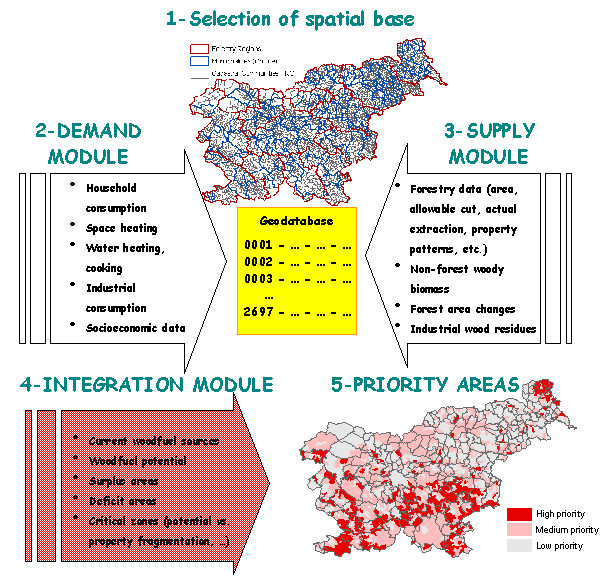
The use of WISDOM involves five main steps, as shown in the diagram in Figure 5:
Figure 5: Diagram of the main steps in the development of WISDOM Slovenia.
The WISDOM method is meant to provide several benefits: a) to allow a consistent and holistic vision of the wood energy sector over the entire country and to help in determining priority areas for intervention; b) to allow the definition of critical data gaps resulting from the thorough review and harmonization of wood energy data; c) to promote cooperation and synergies among stakeholders and institutions (such as those from forestry, agriculture, energy, and rural development) - in this, WISDOM combats the fragmentation (of information, of responsibility) that so heavily limits the development of the sector – and, d) to allow the concentration of actions to circumscribed targets and thus to optimize the use of available resources (human, institutional, financial, and others).
Table 3 summarizes key aspects of Slovenia WISDOM and the development of its modules: demand module, supply module, and integration module. Figure 5 provides an overview of the main steps in the development of WISDOM Slovenia. All elements are presented and discussed in detail further below.
Table 3: Main features of fuelwood flows in Slovenia
Main features of fuelwood use in Slovenia |
Slovenia is a biomass rich country. The large forest area (some 60 percent of the country) is accompanied by other land uses which are often rich of woody biomass and by consistent areas of abandoned farmland which revert to forest. The demand for woodfuels is concentrated on fuelwood (the production and use of charcoal being marginal) for household consumption in rural areas. A large part of fuelwood trade is informal as it is either collected by farmers in their own lands and forests or bought locally. The proportion of fuelwood coming from non-forest areas is estimated at over 20 percent of total household consumption. Industrial consumption, such as district heating systems, combined heat and power plants (CHP) and other industrial uses depend mainly on residues from wood processing industries [12]. These industrial uses are still rather marginal and sometimes characterized by obsolete technologies but may grow as viable energy policy alternatives. |
Objectives of Slovenia WISDOM |
To integrate the rich but fragmented information relevant for wood energy planning available in Slovenia in a spatially explicit dataset and to fill critical information gaps. To understand the true potential of wood energy as an economically and environmentally sound alternative or complement to fossil fuels. To identify the zones of the country most, or least, suitable to the development and implementation of wood energy projects. |
Minimum Administrative Spatial Unit of Analysis |
The spatial base was developed on cadastral communities (KO), which represent the basis of Slovenia territorial structure. With 2696 units, the KO allows for a highly discreet spatial analysis and may be aggregated at municipal level and at any other reporting level. Additional layers are settlements (5997 points). |
Demand Module |
The main sources for the development of the module were: a) census data on dwellings that use fuelwood; b) estimated energy requirements for heating and other domestic uses; industrial consumption (partial data on 65 biomass systems). |
Supply Module |
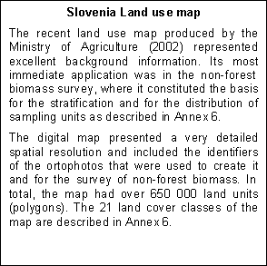
Concerning forest areas, the basis of the module was the rich and regularly updated SFS database on forest compartments (over 65 000) and its new digital map, which provided information on stocking, annual increment, assortments production including fuelwood, actual cut quantities, ownership data, etc., all at KO level. Concerning the non-forest fuelwood sources, a specific survey was carried out, following a two-phase approach based on available ortophotos, the new Land Use Map (2002) and field sampling. Additional layers included are: i) forest area changes 1975 -2000; ii) distribution of wood processing industries. |
Integration Module and priority zoning |
A GIS was created using an ArcGIS platform. The geodatabase created includes all available consumption and supply parameters for each of the 2696 KOs and other point data. An additional set of variables was created integrating supply and demand, such as various balances of production/consumption values to indicate the pressure on fuelwood resources and potential surplus of fuelwood for advanced wood energy initiatives. The indexing of all the variables and indicators and further grouping will be conducted to rank KOs into various categories and priority levels. As example, priority zoning was done in respect of fuelwood production potential, property fragmentation and overstocked young forests at thinning stages. |
The digital map of Katastrske Občine (KO) - cadastral communities – was used as spatial base. The KO layer is composed by 2696 units, which represent the basis of Slovenia’s territorial structure and can be aggregated (almost directly) to form municipalities, forestry regions, and practically all other administrative subdivisions (Figure 6, top map). KO subdivision is compatible with demographic and socio-economic data collected by the Slovenia Statistical Office.
Although the KO structure is very old, it is subject to continuous refinement. The most recent and consistent version of the KO map, updated in January 2003, was used as spatial base in the present study.
The forest compartment database contained KO reference codes, but the direct aggregation of forestry parameters at KO level could not be done since the correspondence with the digital KO map was not always consistent. To overcome this inconsistency the forest compartments map and KO map were intersected in order to establish a unique correspondence, as discussed under Supply module below.
Figure 6. Top: Cadastral communities (2696) and forestry
regions (14);
Below: Settlements (urban and rural) here shown by population size
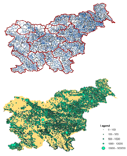
Another important cartographic layer represents the distribution of human settlements (Figure 6 bottom map), composed by 5997 points providing basic demographic data and divided into urban and rural. The settlements were also used to locate wood processing industries, district heating systems and other wood-based industrial plants.
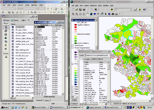
The spatial and statistical data was structured in the form of a geodatabase, named KOWISDOM, which combined the spatial and statistical elements and allowed a convenient handling in both Microsoft Access (database features) and ESRI ArcMap environments.
Figure 7 shows a screen grab of Access and ArcMap while viewing the file KOWISDOM. The attribute table of the file is viewed as both Access table (left) and shapefile and related table of attributes (right). The thematic contents of the database, i.e. the attributes associated to the KOs, resulted from the development of the Demand, Supply and Integration modules described below. The values are listed in Annex 4.
Figure 7: Screen grab of Access and ArcMap while viewing the KOWISDOM geodatabase
The attributes may be grouped in the following four categories:
Administrative elements: code and name of Cadastral Community (KO), Municipality, Region, and other administrative units; settlement locations with relative population data and urban/rural classification.
Demand-related variables: population variables (total fuelwood users, saturation, etc.); number and surface of dwellings using wood for heating; estimated household fuelwood consumption for house heating and cooking (original contribution of the current study); data (still rather incomplete) on existing biomass systems such as district heating systems, combined heat and power plants and other non-specified.
Supply-related variables: total and exploitable forest area; type and number of forest owners; total wood stocking and increment; area by forest phase development stage; forest area by accessibility class; annual allowable cut as well as actual extraction for main wood assortments and species group; area by land use classes (21 classes); estimated stocking volumes, increment and productivity of non-forest land use classes (original contribution of the current study).
Integration variables: This is a very open category where demand and supply-related variables may be combined. Key integration variables produced are (i) KO-level balances between fuelwood consumption and several supply scenarios and (ii), an example of priority zoning determined through the combination of surplus areas with ownership fragmentation and with forests at thinning stages.
At present, almost the entire consumption of fuelwood in Slovenia is absorbed by the household sector and principally for space heating, for which this fuel provides about one third of the national energy demand as revealed by the 2002 census [13]. However, in spite of its relevance, reliable statistics on fuelwood consumption did not exist.
To fill this essential information gap, new consumption estimates8 were therefore produced using the following data sources:
• Number of dwellings, surface and persons living therein that use wood as exclusive or primary fuel for space heating; fraction of occupied dwelling9. Source [13]
• Energy requirements for house heating (kWh/m2) by type of apartment, construction year, level of insulation and maintenance. The estimated energy requirement for heating only used, as main reference, the weighted average for single-family houses (see Annex 3). Source [9].
• Estimated additional energy requirements for cooking and water heating. The total energy requirement for heating and cooking was estimated by adding 30% to the amount required for heating only (see Annex 3). Source [8].
• Energy conversion factors; average wood energy
contents and conversion efficiency in Slovenia.
Fraction of apartments’ surface actually heated. Source [12].
Figure 8. Saturation of fuelwood users (fraction of the dwelling using primarily or exclusively fuelwood for space heating).
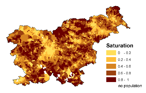
Census data on dwellings allowed estimating the saturation of fuelwood use for space heating by KO, as shown in Figure 8.
The data sets described above allowed for estimating the wood energy requirements described in Annex 3 and summarized in Table 4.
Table 4. Estimated wood energy requirements for space heating, water heating and cooking in Slovenia households.
kWh/m2 |
CUM/m2 |
tons/m2 |
||
Energy requirements per m2 |
208 |
0.11034 |
0.0800 |
|
| Estimated energy/wood consumption by dwellings using wood as exclusive or primary fuel. The estimates refer to the actually heated fraction of occupied dwellings. |
||||
| kWh |
CUM |
tons |
||
Total Slovenia |
11,618,290 m2 |
2,416,604,390 |
1,282,017 |
929,462 |
| kWh/dw |
CUM/dw |
tons/dw |
||
by dwelling |
191,312 dwellings |
12,632 |
6.7 |
4.86 |
| kWh/inh |
CUM/inh |
tons/inh |
||
| by inhabitant |
594,934 inhabitants |
4,062 |
2.2 |
1.56 |
Assumed wood energy efficiency = 65% = 1885 kWh/m3 [12]. |
||||
Figure 9. Fuelwood consumption by Slovenia households.
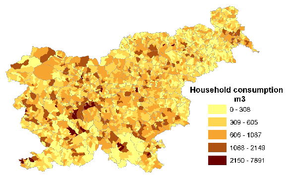
The spatial distribution of household fuelwood consumption for space heating, water heating and cooking in Slovenia households is shown in Figure 9.
Recommended further developments
The estimates of household consumption may be refined to reflect climatic variations using KO-level data on winter temperatures and length of heating seasons. Relevant parameters may be obtained from the Office of Spatial Planning of the Ministry of Environment, Social Planning and Energy, which produces Temperature Zones maps.
In addition to the above, the Demand module should include historical data to analyze recent trends and to allow some projection estimates10. Unfortunately, this is not an easy task, since the previous censuses did not collect data on the types of fuel used for house heating.
The information available on industrial wood energy consumption [10] [12] was fragmented and recent data [2] largely incomplete. Such information was composed by data on 5 district heating systems, 5 combined heat and power plants (CHP) and on 55 industries that have wood-fed boilers of which 21 with some consumption details and 34 without details beyond their location11.
Figure 10 shows the distribution of the biomass systems with some detail about the available information.
Figure 10. Distribution of biomass systems in Slovenia and available consumption data.
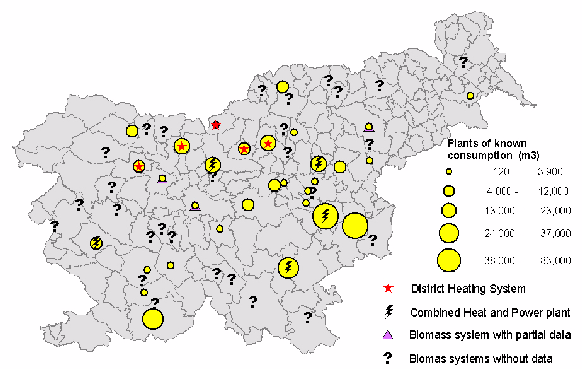
The total consumption from available biomass systems data at year 2002 amounts to some 390 000 m3. This is incomplete since for many units the consumption is not yet known. SFI studies [10] estimated the total consumption in 1997 at 432 000 m3.
Considering this information and the fact that few systems were established after 1997, the value entered in SWEIS was tentatively estimated at 500 000 m3.
In spite of the importance of forest products for energy use and in spite of the excellent existing data on forest resources and outputs, the official statistics fail to provide realistic data on fuelwood production in Slovenia. When we compare the figures of the Statistical Office of Slovenia on fuelwood production shown in Table 5 to the estimated consumption shown in Table 4 above it is evident that the former cannot represent the true amount of fuelwood produced from Slovenia forests.
Table 5: Statistical Office of Slovenia. Production of row wood categories ('000 m3)
1990 |
1995 |
1998 |
1999 |
2000 |
2001 |
2002 |
5-yr average |
|
TOTAL |
1790 |
1751 |
2132 |
2068 |
2253 |
2257 |
2283 |
2199 |
Logs |
979 |
918 |
1001 |
992 |
1120 |
1144 |
1164 |
1084 |
Pulpwood |
281 |
519 |
451 |
434 |
396 |
410 |
414 |
421 |
Other_industrial_wood |
335 |
88 |
142 |
137 |
205 |
408 |
425 |
263 |
Fuelwood |
195 |
226 |
539 |
505 |
532 |
295 |
280 |
430 |
Source [14] |
||||||||
It is apparent that 280 000 m3 of fuelwood (or 430 000, if we take the 5-years average) cannot satisfy the needs of some 600 000 people [13] that use of wood for household heating, cooking and water heating (to consider only the household sector). Fuelwood production is definitely much higher than reported in official statistics but hidden under other categories.
In order to develop the supply module with reliable and detailed data, the original forest compartment databases were used [11]. These databases are maintained by the SFS for the approximately 65 000 forest compartments that compose Slovenia forests. Compartment data relative to the period 1991-2001 were aggregated at KO level to form the databases described in Annex 5.
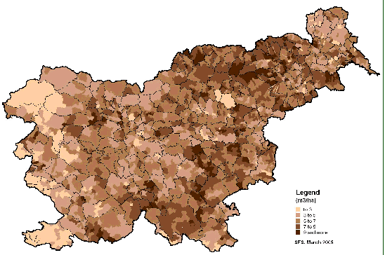
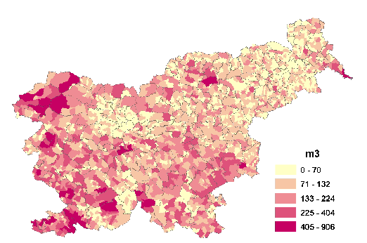
Some important characteristics of Slovenian forests according to KO level statistics, such as forest cover, stocking and mean annual increment, are shown in figures 11 to 13.
Figure 11. Share of KO surface covered by forest.

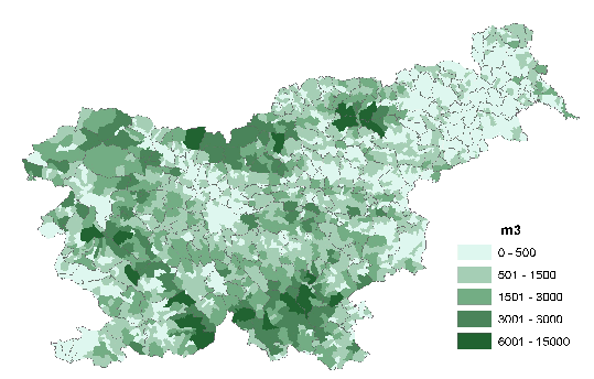
Figure 12. Average forest stocking – m3/ha of forest.
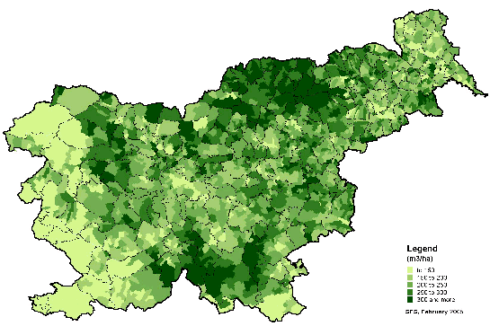
Figure 13. KO-level average of Mean Annual Increment (m3/ year / ha of forest).
Forest compartment databases maintained by the Forestry Service are extremely rich, with data on many aspects of Slovenia forests, including:
• total and exploitable forest area;
• type and number of forest owners;
• total wood stocking and increment;
• area by forest phase development stage;
• forest area by accessibility class;
• annual allowable cut as well as actual extraction for main wood products assortments and species group
This last dataset was the basis for the estimation of the amount of wood exploitable and actually extracted. The assortments considered, were the following:
• Fuelwood assortments from species group “Other hard broad leaved trees” (Carpinus, Ostrya, Fraxinus ornus, Robinia, Acer campestre, Sorbus, Quercus pubescens). This is the only assortment officially recognized as “fuelwood”.
• Non-timber assortments commonly used as fuel (including Larch, Beech, Oak, Chestnut, and other quality broadleaves – groups B, C, and D in Annex 5)
• Non-timber assortments of all species (all conifers included)
The first assortment (the one specifically classified as “fuel”) represents only a small fraction of the volume actually used as fuel estimated in the Demand Module (17% if we consider the allowable cut and 10% if we consider the actual cut). However, practically all foresters interviewed recognized that other non-timber assortments are also primarily used as fuel [11].
The second assortment class, i.e. “Non-timber assortments commonly used as fuel” represents today’s main “forest” fuelwood supply for household use. It is likely that In addition to the amount reported there is a certain amount of “informal” and unrecorded forest extraction.
Figure 14. KO-level distribution of allowable cut of all non-timber assortment.
The third assortment class “Non-timber assortments of all species” represents the potential wood energy supply for household and industrial use in the near future, especially if the actual extraction will be increased to match the sustainable production capacity or at least the conservative levels defined by forest managements’ allowable cut. The distribution of this assortment class is shown in Figure 14.
The volumes were estimates of both allowable cut and actually extracted amounts. The ratio between actual extraction and the allowable cut depended mainly on ownership factors. Over the period 1991-2001 the ratio appeared to be, on average, 0.54 for privately owned forests, rural communities and religious institutions and 0.76 for state forests [11]. Total values for all categories are given in Annex 4. Table 6 below reports the aggregated values of most relevant forest production parameters. These values are reported, in comparison with consumption levels, in Table 2 in the previous chapter.
Table 6: The most important data on the supply of fuelwood from the forests on the State level
Forests |
|
Total forest area |
1.185.306 ha |
Exploitable forest area |
1.104.794 ha |
Allowable cut by management plans |
|
Non timber assortments commonly used as fuel (group BCD)* |
1.407.000 m3 |
Non timber assortments of all species (all conifers included) |
2.148.000 m3 |
Volumes actually extracted (average over the period 1991-2001) |
|
Non timber assortments commonly used as fuel (group BCD) |
840.000 m3 |
Non timber assortments of all species (all conifers included) |
1.283.000 m3 |
Notes:
*See Annex 5 for explanation.
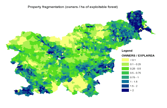
Among the many perspectives that this rich dataset provides, a particularly interesting one concerns forest ownership, which allows for the distinction of forest area by levels of property fragmentation shown in Figure 15. Fragmentation of forest properties poses many problems for the implementation of forest policies, as many owners have marginal interest in their forest lots or simply do not know where they are. In fact, the efficiency of execution of allowable cuts seems inversely related to the fragmentation of forest ownership.
Figure 15 : Forest ownership fragmentation. Number of forest owners per hectare of exploitable forest co-owners are not considered.
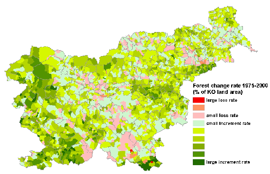
The recent study on forest area change over the period 1975-2000 [4] estimated that Slovenian forests have grown at an average annual rate of 0.4 %. The area of forest has increased of over 116 000 ha in 25 years, passing from 1 085 000 to 1 201 000 ha. The spatial pattern of forest area change is shown in Figures 16 and 17, the first in absolute terms (ha of change) and the second in relative terms (percent of KO area). The increase in forest area is due mainly to abandoned marginal farmlands.
Figure 16 : Forest area change over the period 1975-2000.
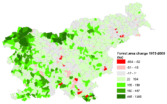
Figure 17 : Forest change rates as percent of KO land area over the period 1975-2000.
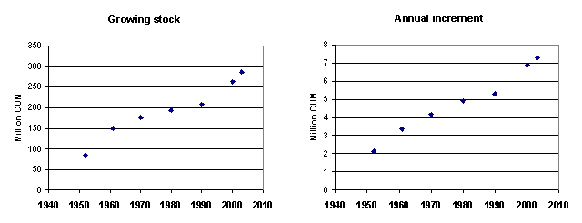
Other important aspects that strengthen the potential sustainable supply of fuelwood in the years to come are the steady growth in forest stocking, which grew from 207 million m3 in 1990 to 286 million m3 in 2003, and the similar growth of the mean annual increment, which increased from 5.3 million m3 in 1990 to 7.3 million m3 in 2003 [11] (Figure 18).
In fact, the current allowable cut, which is the basis of the sustainable productivity assumed in this study, is very conservative; it represents less than 60% of the estimated annual increment.
It can therefore be assumed that the potential supply of woodfuels could more than double today’s extracted volumes without limiting the timber industry or affecting the growing stock. On the contrary, fuelwood production especially through thinning operations would have a positive effect on forest health condition, on stands resistance to extreme weather conditions and on the quality of timber products.
Figure 18 : Change of growing stock and mean annual increment.
 Slovenian
landscape is rich in woody biomass both within and outside forest areas. In
addition, dense natural vegetation builds up in marginal abandoned farmlands
in a continuous process that produces a net increment of the country’s
woody biomass resources. However, although it is known that a significant
part of fuelwood for household use is collected by farmers in their own lands,
no information existed on the stocking and productivity of non-forest areas
or on the current and potential role of these areas in planning sustainable
wood energy systems.
Slovenian
landscape is rich in woody biomass both within and outside forest areas. In
addition, dense natural vegetation builds up in marginal abandoned farmlands
in a continuous process that produces a net increment of the country’s
woody biomass resources. However, although it is known that a significant
part of fuelwood for household use is collected by farmers in their own lands,
no information existed on the stocking and productivity of non-forest areas
or on the current and potential role of these areas in planning sustainable
wood energy systems.
This item represented a major information gap in the Supply Module. In order to acquire basic reference values, and therefore to fill such information gap, a survey of non-forest areas was implemented using the recent Slovenia Land Use Map, ortocorrected aerial photographs and field measurements.
A description of the design, sampling scheme and results of the non-forest biomass survey is provided in Annex 6, while summary results are given in Table 7.
Table 7: Summary results of non-forest woody biomass survey
Mean Stocking |
Mean Increment |
|||||||
Code |
Land use classes |
Total area (ha) |
m3/ha |
CV% |
m3/ha/yr |
CV% |
total stocking |
total increment |
1100 |
Fields and gardens |
213,985 |
3.0 |
119.56 |
0.10 |
121.69 |
649,466 |
21,958 |
1221 |
Intensive orchard |
5,049 |
33.1 |
78.84 |
1.12 |
79.53 |
167,004 |
5,675 |
1222 |
Extensive orchard |
19,849 |
32.1 |
48.94 |
1.14 |
47.83 |
637,212 |
22,591 |
1310 |
Intensive meadow |
159,652 |
8.5 |
82.43 |
0.28 |
85.27 |
1,358,629 |
44,579 |
1322 |
Extensive meadow |
187,930 |
19.5 |
73.74 |
0.67 |
73.77 |
3,670,979 |
126,499 |
1410 |
Re-growth on old farmland |
25,246 |
57.4 |
63.11 |
2.16 |
59.84 |
1,449,435 |
54,498 |
1500 |
Mixed use (agric / forestry) |
18,953 |
94.6 |
48.82 |
3.30 |
46.58 |
1,792,963 |
62,624 |
3000 |
Urban and built up areas, roads |
108,194 |
15.6 |
80.44 |
0.51 |
83.75 |
1,691,725 |
55,430 |
738,858 |
15.5 |
0.53 |
11,417,413 |
393,854 |
||||
The results achieved give us the first objective estimation of wood stocking and annual increment outside forest areas.
Inevitably, due to the very heterogeneous character of non-forest landscapes, the variability is very high, as shown by the coefficients of variation close to 100% for several classes (which means that the standard deviation and the mean have similar values). Preliminary statistical analysis indicates that the confidence interval, calculated through logarithmic transformation at 90% confidence, ranges between 0.3 and 26 m3/ha for stocking (mean 15.5) and between 0.12 and 3.21 for the increment (mean 0.53).
The productivity, in terms of fuelwood volume annually exploitable, has been estimated as 70% of the annual increment, which gives a national total of some 276 000 m3/ha/year. The spatial distribution, by KO, of the estimated fuelwood productivity is shown in Figure 19.
Figure 19 : Fuelwood productivity in non-forest land use classes.
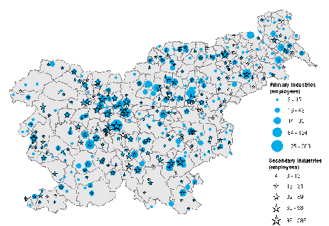
The best available information on wood residues from forest industries and their use for energy is in the 1998 study by SFI [10], which provides summary data with reference year 1995. For that year the total annual production of wood residues was estimated at 722 000 m3. The new data on wood industries that could be acquired in the frame of the project was limited to number of employees of primary wood industries (sawmills) and secondary wood industries (mainly furniture making) by settlements. This dataset is mapped in Figure 20.
Figure 20 : Distribution of primary and secondary wood processing industries.
In the near future there will be considerable detailed data on wood residues and other waste material, as a result of the full implementation of Government prescriptions (and EU regulations). For the time being, however, the information available is insufficient for a spatial analysis of residue production and consumption. In qualitative terms it is known that most residues are for industrial consumption, mainly by biomass systems within the wood processing industries or by district heating systems.
In the development of SWEIS the production of wood residues after the 1995 reference date [10] was estimated to decrease with direct correlation to the reduction trends of industrial wood products, as reported by the Slovenia Statistical Office [14]. Accordingly, the production at year 2002 was tentatively estimated at some 553 000 m3.
The integration module focused on the analysis of the supply/demand balance between fuelwood consumption and forest/non-forest production.
More specifically, the analysis concerned the KO-level balance between:
• household fuelwood consumption and
• several supply scenarios determined by current and potential forest and non-forest productivity. Key parameters used were
• actually extracted vs. allowable cut as per management plans;
• wood assortments and species groups commonly used as fuelwood vs. assortments and species potentially used as fuelwood (always limited to non-timber resources).
KO-level balance statistics were included in the WISDOM geodatabase and summarized in Annex 4.
The results, at national level, of the balance analysis and its possible scenarios are discussed in Chapter 2: “Results and Findings”. In the same Chapter, Figures 1 and 2 show the maps representing the geographic pattern of resulting surplus and deficit conditions of the two most representative scenarios:
• The current fuelwood consumption/production situation. The map reports the balance between the actually extracted wood from preferred fuelwood species (all non-timber assortments from hard broadleaved and Larch) plus the wood produced outside forests and the household consumption of fuelwood.
• The potential sustainable surplus of woody biomass on which the expansion of wood energy could be based. The map reports the balance between the total allowable cut of all non-timber assortments from all species (including assortments and species not used as fuelwood in households) plus the wood produced outside forests and the estimated household fuelwood consumption.
Table 2 in Chapter 2 summarizes consumption and production values and derived national level balances.
Since the information on industrial woodfuel production and consumption was still partial, the analysis was limited to supply/demand balance related to household consumption and forest/non-forest productivity.
On the other hand, this limitation did not seem to reduce the validity of the analysis done and the conclusions achieved for the household sector. In fact, as discussed before, there are two fairly independent woodfuel circuits: a “household” circuit that uses mainly fuelwood (and marginally charcoal) from forests and farmlands (the one represented by the balance analysis) and an “industrial” circuit that uses mainly residues from wood industries and paper mills.
To bridge between these two circuits and to study the potential for industrial wood energy development, the analysis focused on the determination of (i) the total woodfuel potential according to current forest management plans, and (ii) the zones of the country where there is a significant biomass surplus (after having satisfied household needs) that could feed district heating systems, power generation systems or other industrial plants.
As example of the power of the WISDOM geodatabase to assist in operational and strategic planning, one priority zoning analysis was carried out on a theme, arbitrarily selected, among the many that may interest forestry and wood energy planners.
The scope of the priority analysis was to identify the areas of the country most suitable for the implementation of field programs oriented towards: (i) the promotion of forest owners associations, (ii) the increase of woodfuel production and (iii) the execution of thinning in overstocked forests.
The priority zoning was determined through the combination of the following three aspects:
• high wood surplus considering current local consumption and potential sustainable productivity (see Figure 2),
• high fragmentation of forest property (see Figure 15), and
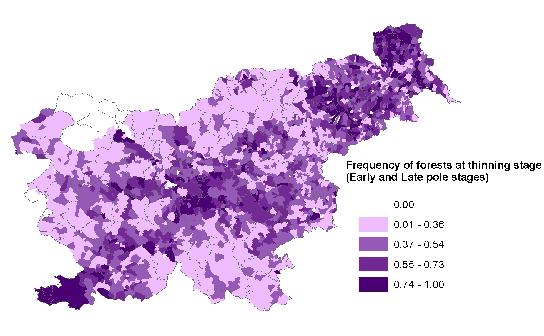
• high fraction of forests at early and late pole stages, which are the stages of forest growth that require thinning operations (see Figure 21).
Priority areas were determined by means of an indexing approach in which the range of values of each thematic aspects was first ranked into 5 categories, reflecting a priority level in respect of the problem under analysis (rank 1= low priority; rank 5= high priority).
In the example carried out, the following indices were created:
• Supply/demand balance index: (higher (positive) balance = 5; lower (negative) balance = 1)
• Property fragmentation index (high fragmentation = 5; lower fragmentation = 1)
• Thinning stage index (higher fraction of forest at pole stage = 5; lower fraction = 1)
Figure 21 : Fraction of KO forests requiring thinning operations.
The combined index, which may be called Thinning Priority Index (TPI) was calculated as follow:
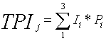
where,
TPIj = thinning priority index for each KO “j”
Ii = index for each of the 3 variables used in the analysis, ranging from 1 to 5
Pj = weights, set to 1 in this case
The resulting TPI was again ranked into 3 levels, where the new “high priority” index grouped the areas with high indices in respect of all three parameters. The thematic map resulting from this analysis is shown in Figure 4, Chapter 2: “Results and Findings”. The map provided a delineation of priority KO for the implementation of field programs geared towards solving the problem of “undone thinnings” through the promotion of owners associations and the increase woodfuel production.
As discussed earlier, WISDOM is conceived as a strategic planning tool to be maintained, deepened and, most important, used by wood energy planners. In this respect, the analytical conclusions and priority zoning so far defined should be considered as the first steps in the analysis of this sector and not the conclusion of a process. The priority zoning carried out, for instance, was an example of analysis rather than the definition of true priorities. Many other aspects can, and hopefully will, be mapped by wood energy planners using the WISDOM geodatabase.
8
See Annex 3 : Household fuelwood consumption estimates
9 See Annex 2: Summary
of statistical data received from Statistical Office of Slovenia.
10 More information
on fuelwood consumption would be generated after the completion of WISDOM
component through the analysis of “fuelwood user profile” that
was carried out by SFI using additional statistics from the census 2002 and
from the census of agricultural holdings (2000) (see variables in Annex 2).
11 Additional information
on wood waste was generated by SFI after the completion of the WISDOM component
of the Project (see Chapter “Project follow-up – WISDOM development”).
However, since the response to the questionnaires sent out was not complete
at the time of writing the estimated values were not replaced.
