


B. plurijuga (Zambezi teak) forests occur in Angola, Botswana, Namibia, Zambia and Zimbabwe in southern central Africa (Figure 1). Baikiaea plurijuga is the southernmost species of the genus that is mainly confined to the topical lowland rain forest of the Guinea-Congolian floral region. Baikiaea plurijuga’s spread southward into the Zambezian region is largely due to the moisture retention of the deep Kalahari sand that favours the regeneration of the species. KS teak forests are restricted to the Kalahari sand under an annual rainfall regime ranging from more than 1000 mm in south-east Angola in the north to less than 600 mm in north-western Zimbabwe in the south (Huckabay, 1986).
In Zimbabwe the KS teak forests are restricted to the western part of the country. The forests are located between latitude 170 05’S and 200 02’S and longitude 150 00’E and 190 00’E. They straddle two provinces, i.e. Matabeleland north and midlands and seven rural districts (Table 1). Almost all forests share common boundaries with at least one or more of the following land categories: communal lands, resettlement areas, large and small-scale commercial farms and national parks.
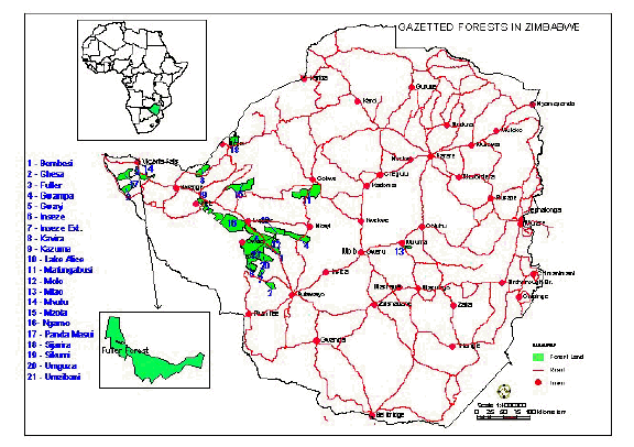
Figure 2. Protected KS teak forests in western Zimbabwe. (Source: Forestry Commission, 2006)
Table 1: Protected forest reserves in western Zimbabwe
District |
Forest land |
Area (ha) |
Productive (ha) |
Non-productive (ha) |
Binga |
Kavira |
28 200 |
8 600 |
19 600 |
Sijarira |
25 600 |
- |
25 600 | |
Mzolo |
67 000 |
35 000 |
32 000 | |
Bubi |
Bembesi |
55 100 |
39 240 |
15 860 |
Molo |
2 900 |
2 580 |
320 | |
Lupane |
Gwaai |
144 300 |
105 020 |
39 280 |
Lake Alice |
39 000 |
24 360 |
14 640 | |
Ngamo |
102 900 |
56 210 |
46 690 | |
Nkayi |
Gwampa |
47 000 |
35 490 |
11 510 |
Umguza |
Chesa |
14 248 |
6 780 |
7 468 |
Inseze |
35 200 |
24 550 |
10 650 | |
Inseze Extension |
8 400 |
6 010 |
2 390 | |
Umgusa |
32 200 |
28 500 |
3 700 | |
Umzibani |
2 471 |
2 260 |
211 | |
Hwange |
Fuller |
24 700 |
16 470 |
8 230 |
Kazuma |
24 000 |
15 420 |
8 580 | |
Panda Masuie |
33 500 |
29 300 |
4 200 | |
Sikumi |
55 700 |
24 750 |
30 950 | |
Gokwe |
Mafungabusi |
105 000 |
48 000 |
57 000 |
Totals |
847 419 |
508 640 |
338 779 |
(Source: Judge, 1975; Forestry Commission, 1994).
The dominant climatic characteristic in the KS teak forests of western Zimbabwe is a short and erratic rainfall season from mid-November to mid-March. The dry season ranges from April/May to October/November. The average annual rainfall for the region is about 600 mm. The long-term (45 years) average annual rainfall for Victoria Falls in the north is about 450 mm, for Gwaai forest in the central area it is 650 mm, for Chesa forest in the south it is 600mm, and for Mafungabusi forest near Gokwe in the north eastern area of the region about 680 mm (Anderson et al., 1993). There is considerable year-to-year variation, such that in some low rainfall years the average annual rainfall is below 300 mm and in high rainfall years above 800 mm. Mean annual temperature in the region is approximately 21.50C. Mean monthly temperatures in the hot and cold months are about 300C and 170C, respectively (Nyamapfene, 1991). In terms of agro-climatic classification the forests generally fall within Natural Region IV. Natural Region IV is suitable for extensive livestock production and wildlife ranching. The exceptions are parts of forest areas in Mafungabusi and Mzolo that fall in Natural Region III. The low and erratic rainfall comprises a major constraint to dryland crop production and is also a major determinant of the annual availability of grass for livestock production.
Kalahari sand covers the bulk of the protected KS teak forests. The sands comprise deep, unconsolidated and well-drained tertiary sands of Aeolian origin. The underlying geology is of sedimentary rocks overlying Karoo basalt and sedimentary deposits. These underlying formations are only exposed along rivers where the sands have been eroded. The dominant KS soils are uniform physically and chemically (Anderson et al., 1993; Nyamapfene, 1991). The extremely low occurrence of silt and clay particles (< 10 percent) is due to the absence of any weather resistant minerals (Lockett, 1979). The soils are also highly infertile. Permeability is rapid and there is very little runoff. High permeability and low fertility severely constrain the potential of the soils for dry land crop production.
The valley soils along drainage lines are different and much more varied. This results from differences in the parent material of reworked Kalahari sand, basalts, sedimentary and alluvial deposits. The common soil type in the valleys is locally known as “isibomvu”, literally meaning red sand soils. This type of soil is moderately well drained, deep, loamy sand highly favoured for agriculture.
There are three major soil colour divisions that can be recognised. These are the darker, finer and more fertile red sands; the pale, coarse, loose, infertile white or grey sands and the intermediate buff sands (Calvert, 1986). The red sands are the least extensive and are found adjacent to valleys and ridges where relief is relatively marked. The pale sands are associated with depressions and flatter areas where drainage is less free. The relatively extensive buff soils are intermediate between the two, in some places apparently overlying pale sands and in others red sands.
