![]()
![]()
![]()
by
C. Cossalter
Ingénieur des Travaux des Eaux et Forêts
Chef de la Mission Graine Indonesie
DISTRIBUTION OF EUCALYPTUS DEGLUPTA PROVENANCES AND LIMITS OF NATURAL RANGE IN INDONESIA
In Sulawesi (Celebes Island)
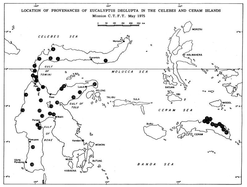
In the Indonesian province of Sulawesi (Celebes Island) Eucalyptus deglupta is known under the vernacular name of Kaju Leda. Between latitudes one degree North and two degrees South, pure stands of this species are growing at a number of locations, both coastal and at higher elevation. Examples of coastal sites in Annex 1 are: Dumoga 1, Tapa 2, Ongka 3, Tolitoli 4, Balukan 5, Kolawi 6, Saweiti 7, Tibao 8, Ampibabo 9, Marantalo 10, Sausu 11, Lariang 14, Kolonodale 16, Bongka 17, Ampana 18, Kabali 19, Batui 20, Balantal 21. Examples of higher elevation sites are: Palolo 12, Gimpu 13, Pindolo 15.
South of latitude 2° S, the natural stands which have been located are more rare, they are mainly concentrated in the coastal plain reaching from Palopo to Malili, north of the Bone gulf, between the S.E. and the S.W. peninsulas (Parara 23, Kaloukou 24, Tobou-Tobou 25, Todantana Padang 26, Mario 27, Kandoa 28). At similar latitudes the natural stand of the swampy plain of Sampaga (22) occurs on the west coast.
Below parallel four degrees South, E. deglupta is only found along two rivers (Wempalle river 29 and Berong river 30) flowing toward the west coast. These two locations do not contain stands but scattered trees growing along the torrents which cross the last ridges before reaching the coastal plain. The natural stand of Parenglui on the Berong river is the farthest location from the equator of the Indonesian E. deglupta. Parenglui is located at 5°15' S in the extreme S.W. of the island.
Mr. Ardikoesoema, forester from the Bogor Institute, has reported that natural stands of E. deglupta have been found on some mountains in the western part of Flores, in areas where rainfall is particularly high. If this information is correct, the natural limit of E. deglupta in Indonesia would reach 8°30' S, close to the N.W. limit of the range of E. urophylla. Provenances from Flores would be, with provenances from Papua New Guinea, the least equatorial within the entire species range.
In Ceram Island
Contrary to Celebes, where it occurs over a wide range of ecological conditions from the coast to elevated plateaux, it seems that in Ceram E. deglupta (called Kaju Patola in the vernacular language) is limited to a few sites located in the eastern part of the island. It grows along rivers with an average length of 10 to 15 km, which rise in the northern and eastern slopes of this mountainous island and flow across a narrow coastal plain covered, like the slopes, with tropical rain forest. The main stands of E. deglupta in this area are found on the banks of rivers which have the strongest flow (Samal river 35, Matakabo 36, Boebi 37, Masiwang 40) but it also occurs along smaller rivers (Wahi river 31, Taloearang 32, Moeal 33, Isal 34, Lola 38, Nif 39). The western limit seems to be the Wahai river, flowing north in the central part of the island.
Documents of the Agricultural Services in Ambon report that the species occurs also on the S.E. coast of Ceram. Unfortunately no further details are available about the accurate location and appearance of these stands. With the inclusion of this occurrence, the natural range of E. deglupta in Ceram would extend between latitude 2°45' S and 3°45' S. No mountain stand has been located in Ceram.
CLIMATIC DATA
Celebes Island
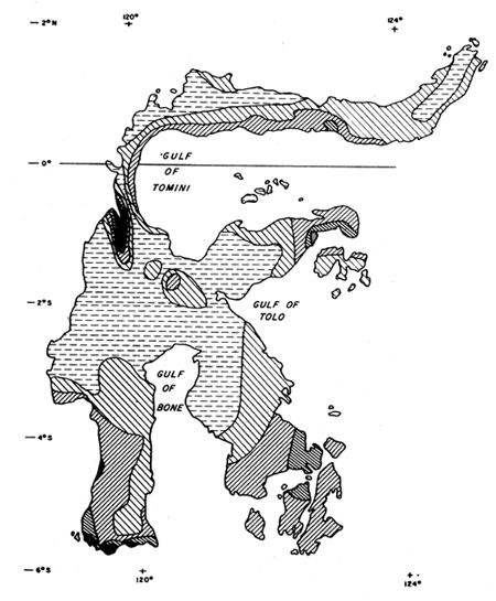
Climatic factors are the main reason why the species is restricted in Indonesia almost entirely to a strip 5 degrees wide, on both sides of the equator. Most of the provenances are concentrated in coastal plains close to latitude 0°. A hot and very humid climate, with high rainfall and no dry season, is particularly well suited for this species. The following climatic data are characteristic over a great part of the Celebes coast, independently of the exposure and aspect:
In a normal year, monthly rainfall is over 100 mm during a period of 9 to 11 months a year and less than 60 mm for one month. Exceptionally, the dry period (less than 60 mm a month) may last 3 or 4 months in a few places. This type of climate is typical of the provenances of the western coast to latitude 3° S (provenances 4,5,6,7,8,14,22), of the provenances of the coastal plain north of the Bone gulf (provenances 23,24,25,26), of the provenances of the Poso area on the Tomini gulf (provenances 11,17,18) and of the Kolonodale area on the Tolo gulf (provenances 16,19).
Provenances occurring on the plateaux of the central massif, near the Lindu and Poso lakes, have similar conditions (provenances 12,13,15), but mean annual temperature is slightly lower (around 22 to 24° C) due to the altitude which varies from 500 m to 1 000 m. The dry season is even less marked than on the coast. Monthly rainfall may drop under 60 mm for 1 or 2 months in the driest years but usually the dry period lasts only 10 to 20 days a year. In an average year, 11 months have more than 100 mm of rainfall and total rainfall in the year may reach 5 000 mm.
The coasts of Tomini gulf facing east and south, the tip of the Luwuk peninsula and the S.W. coast of the island are subject to drier climatic conditions. Average annual rainfall varies from 1 500 mm to 2 300 mm and there are 3 or 4 dry months with less than 60 mm of rainfall. The dry season may exceptionally last 5 to 6 months. The wet season (over 100 mm a month) usually lasts 7 to 8 months. This type of climate corresponds particularly to provenances 2,3,9,10,20,21.
Ceram Island
On Ceram island, the climate of the N.E. and east coast is intermediate between the two types of coastal climate in Celebes. Total annual rainfall is around 1 800 mm to 2 300 mm, the dry season normally lasts 1½ to 3 months, and 5 to 6 months during occasional dry years, the wet season lasts 7 to 9 months. Provenances 31 to 40 are subject to such conditions as are provenances 27 and 28 from the Bone gulf in Celebes.
All these types of climate found in the natural range of E. deglupta are classified as Afa code in the climatic description of Köppen.
REGENERATION, CHARACTERISTICS OF NATURAL STANDS AND HABITAT
Regeneration
Flower buds appear at the height of the wet season as rainfall and vegetative growth reach their maxima. Heavy flowering usually follows the wettest period. Within 12 weeks buds develop into mature capsules; when ripe, fruits keep their seeds for 2 or 3 more weeks before opening. The period of seed dissemination occurs at the end of the wet season, as the flood water retreats and large banks of gravel and sand mixed with silt are uncovered in the river beds and along the banks. The diminishing river flow deposits the seeds in full sunlight, on the banks bare of vegetation. These are ideal conditions for seed germination and for establishment and growth of seedlings (photo No. 1). Successive deposits of silt during the later flooding periods build up the soil of the future forest.
Characteristics of Natural Stands
E. deglupta is a light demander. It is very demanding in its water requirements and will tolerate neither poor drainage and stagnant water, nor a water table of excessive depth. Its requirements for soil water and regeneration explain both its habitat and the structure of the natural stands. It is restricted mainly to the banks and islets of rivers, which it colonises in pure, even-aged groups of limited area. These uniform high forest groups contain trees of slender form, growing at high density and all of approximately the same size.
During the first stage of development, the understorey is missing. Species of the tropical rain forest such as Vitex cofanus, Dillenia sp., Plerospermum celebicum, Calamus sp., Pangium edule, Dracantomelan mangiferum, Calophyllum soulathi become established late under the canopy of mature stands.
Under the oldest stands such as Tobou-Tobou on the Tomini river (provenance 25), a dense second stratum of forest has become established. The density of the dominant E. deglupta is around 30 to 40 trees per ha, the average tree reaches the following dimensions:
The biggest trees of this stand have a total height of 75 to 80 m and a DBH of 150 cm (photo No. 2). Closed stands of E. deglupta do not contain natural regeneration at any stage of their development.
Habitat
From the mouth to the source of a river, many suitable sites can be found for E. deglupta to become established. The species may occur along the last meanders of a river in the coastal plain. In Ceram it extends downstream as far as the river remains non-tidal. In Celebes no provenances have been found less than 15 km from the sea. It can also colonise banks of torrents in the upper valleys (photo No. 3).
Plateaux seem to be particularly suitable for the species to become established and to spread. On the Palolo plateau at the confluence of the Sopou and Lindu rivers, the banks of both rivers are covered with a mosaïc of groups varying in age from patches of seedlings to mature stands of approximately 100 trees per ha, 50 m tall and 1 m in DBH (photo No. 4). Gimpu plateau on the upper part of the Lariang river is another good example of the vigour of the species on this type of site.
The spread of the species mainly depends on the size of the stream. Along torrents running down steep mountain slopes, the species is restricted to some clumps of small area, sometimes only scattered trees (Tampak and Ampibabo rivers for instance). In Ceram the species occurs along large and medium sized rivers. Stands are more frequent and of bigger area on the bigger rivers. On these, they often increase as one goes upstream.
In areas like the coastal plain situated north of the Bone gulf, where there are 6 rivers, of which 5 are large, E. deglupta occurs at a number of locations without ever becoming common. Its occurence is occasional.
ANNEX 1
LIST OF EUCALYPTUS DEGLUPTA PROVENANCES IN THE CELEBES AND CERAM ISLANDS
CELEBES ISLAND
CERAM ISLAND
* Sites visited by C.T.F.T. Seeds Mission during May 1975.
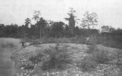
Patch of natural regeneration of Eucalyptus deglupta located on the banks of the Sopou river (Palolo plain, central Celebes, provenance No. 12). Photo COSSALTER No. 1.
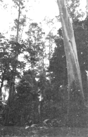
Stand of Tobou-Tobou on the banks of the Tomini river (central Celebes provenance No. 25). Photo COSSALTER No. 2.
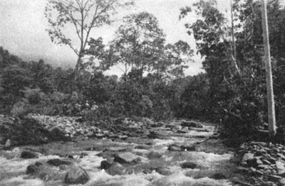
Eucalyptus deglupta growing on the banks of the Tampak river (central Celebes, provenance No. 27). Photo COSSALTER No. 3.
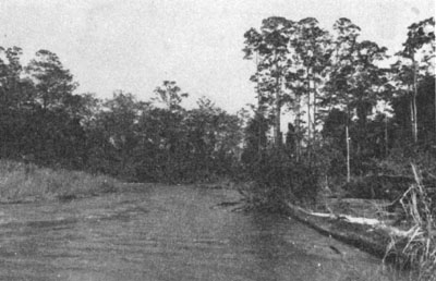
Clumps of Eucalyptus deglupta of various ages growing on the banks of the Lindu river (Palolo plain, central Celebes, provenance No. 12). Photo COSSALTER No. 4.
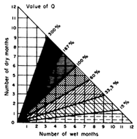
TYPE OF RAINFALL IN THE ISLANDS OF CELEBES AND CERAM
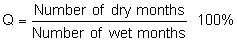
Based on the relationship between the number of dry and wet months
| Extract from the map: VERHAN DEL INGEN mapr djawatan meteorologi dan geofisik DJAKARTA |  | |
 |  | |
| ||
Remarks: For a given station, the value used for the number
of dry months is not the number of months of which
the mean monthly rainfall (calculated over a large
number of years) is less than 60 mm. It is the
number of months in which the rainfall every year
over a number of years is less than 60 mm. This
criterion is stricter than that of the number of
months of which the mean rainfall is less than 60 mm
and therefore results in a lower value for the number
of dry months, because there is no compensating effect
of one year on another. | ||
| The number of wet months is calculated in the same way. This method of calculating the length of the dry and wet seasons takes account of the staggering of the seasonal changes which may occur from one year to the next. It reduces the numbers of “dry” and “wet” months and increases correspondingly the number of “intermediate” months. | ||
  | ||
![]()
![]()
![]()