![]()
![]()
Hans Jurg Steinlin
HANS JURG STEINLIN is Professor of International Forestry and Land Use and Director of the Institute for Land use at Albert Ludwigs University, Freiburg, Federal Republic of Germany. Between 1973 and 1976, he was Director of the Forest Resources Division, FAO Forestry Department
The FAO/UNEP Tropical Forest Resources Assessment project has set a "base line" for objective measurement and comparison of tropical forests. This means that monitoring of the extent and condition of tropical ecosystems throughout the world is finally possible and practical.
About a third of the earth's surface has suitable climatic and other environmental conditions to support the growth of forests. Another a third - chiefly steppes, semi-deserts and deserts - is too dry to support closed forests and most types of open forest, and the remaining third is too cold for trees to grow. What is historically significant is that the area that can support forest growth is also the one offering the most favourable conditions for human life. From the earliest time, mankind - and, therefore, economic and social development - has tended to concentrate in the forested regions of the earth. It is here that over centuries man has cleared large forest areas and converted them to other land uses, and it is here that he has made the greatest changes in the earth's vegetation. This process of conversion is still taking place, but it has shifted from the temperate zones of Asia, Europe, and North America to the tropics and subtropics, where the population is now increasing most rapidly. In the industrialized countries of the temperate zones, the total forest area is now roughly constant or even slightly increasing. When forests in these countries disappear, the losses are compensated by reforestation or natural forest expansion into agriculturally marginal or sparsely populated rural areas.
Forests in the tropics are another matter. First of all, they assume a great variety of forms. In regions having high rainfall evenly distributed throughout the year, dense rain forests with high biomass production exist. In areas with lower annual rainfall and long dry periods, dense rain forests give way to closed forests that periodically shed their leaves. In areas with low annual rainfall or long dry periods, or both, vegetation consists of open forests, wooded savannas, shrub and thicket formations and semi-deserts where woody plants are marginal. From the ecological point of view, all the different forms of tropical forest are significant, and the disappearance of any one of them, even within a single region, may have serious consequences.
There are several reasons for the decline in the total forested area in tropical countries, and these vary from region to region, but the main and underlying cause is rapid population growth and the concomitant increased demand for farming and grazing land. In addition, land is needed to produce cash crops in order to earn the badly needed foreign exchange which is another requirement of countries with growing populations. Sometimes this conversion of forest land to other uses is the result of a planned, orderly development. At other times, it occurs spontaneously and without control through various kinds of shifting cultivation. In certain areas, commercial timber exploitation is also a factor in this conversion process, leading to unplanned agriculture where forests have been opened up.
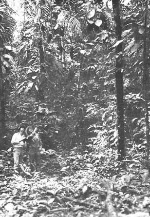
CONDUCTING A FOREST SURVEY IN COLOMBIA toward natural resource instead of waste
|
The disappearance of 4 million hectares a year of open forest, together with the almost imperceptible degradation of the remaining open forests as a result of excessive fuelwood cutting and over-grazing, may be more serious than the threat to the tropical rain forests. |
In developing countries, demands for more land are not limited to food and cash crops. They need to construct settlements and industrial plant, to extract minerals and to build dams, resulting in forest land being permanently converted to some other use.
Since the early 1970s, this noticeable decline of tropical forest - especially the destruction of rain forests - has aroused considerable concern throughout the world. Estimates of the extent of forest destruction differ widely - as do opinions about what to do about it. It should be pointed out, however, that not all studies adopt the same definition of "conversion" or "destruction". Some define conversion as the complete disappearance of forest in favour of other forms of land use; for others it is or includes a thoroughgoing modification of the original ecosystems, a mere degradation rather than a destruction of the natural forest. In the latter case, some studies would regard "degraded" land as still forested, while others would see it as having been "converted".
The reduction of tropical forests - whether moist or dry - should be viewed with ecological, economic and human consequences in mind. The degradation or disappearance of these ecosystems has obvious ecological effects on the immediate environment, but it may also affect distant areas, for instance, agricultural plains or valleys that depend upon forested highlands for their water. Such lands may suffer flooding or drought as a result of the destruction of the forests. Genetic damage and losses of plants, animals and insects can also be serious and possibly permanent. At its most severe, forest destruction can result in erosion which in turn may lead to desertification. The economic and human consequences include the loss of potential wood and paper products which may then need to be imported. The loss of forest, furthermore, may run counter to what is, for many developing countries, the most urgent of all needs - fuelwood for cooking and heating.
Continuous monitoring of the world's forest area was recommended in 1972 at the United Nations Conference on the Human Environment in Stockholm: the Conference proposed that the job be assigned to FAO and Unesco and that existing forest inventories and remote sensing be used. Subsequently, and as a direct result of the Stockholm Conference, the United Nations Environment Programme (UNEP) was founded in Nairobi. By the mid-1970s, FAO and UNEP had developed a joint project for monitoring the world's tropical forest areas. This was to be done mainly with remote sensing methods, satellite imagery and aerial photography. The area to be examined, it was agreed, was the entire land mass that constitutes the tropics in the southern hemisphere. Financial difficulties and doubts about the technical and organization feasibility of such an extensive operation prevented carrying out a large-scale project immediately. However, an experimental project covering three African countries - Benin, the United Republic of Cameroon and Togo - was carried out.
The project can only be judged as a success. It proved, first, that it is possible to monitor forest cover with the aid of a multi-phase technique using satellite imagery, aerial photographs and field observations. Second, it yielded highly interesting data about the forests of the three countries and about the extent and reasons for their destruction. This was a practical undertaking and its results should convince sceptics that the methods employed are indeed applicable to large-scale continuous monitoring of tropical forest areas.
UNEP and FAO were aware that two tasks had to be carried out simultaneously if large-scale continuous monitoring of the tropical forest cover was ever to become a reality.
One was to assist certain developing countries to attain the capability to monitor their own forest cover as soon as possible. The Togo, Benin and United Republic of Cameroon project aimed at this. This kind of budding up of national inventory monitoring capability will have to be done in many other countries of Africa, Asia and Latin America to create a basic level of expertise in this field available to all the forestry countries of the tropical world. Obviously, this will take a number of years.
In the meantime, the second task had to go forward. This was to assess tropical forest resources on a global basis through the compilation and organization of a mass of already existing information regarding the extent and condition of the world's tropical forest ecosystems. This information is widely scattered and too heterogeneous to be useful in making comparisons. It needs to be gathered in one place and converted to basic data in order to provide a satisfactory picture of the present status of tropical forest resources within a relatively short time.
|
The destruction of tropical forests causes famine, floods, erosion, and loss of plants and animals... Only a small part of annual forest losses in the tropics is offset by new plantations |
A project to this effect was launched at the end of 1978 under UNEP's Global Environmental Monitoring System (GEMS) with FAO doing the conceptual and operational world. Mr J.P. Lanly, who for many years has been responsible for FAO's extensive programme of forest surveys, headed the project. He was assisted by an internationally recruited team of experts. The results began to appear in published form after 32 months of intensive work involving about seven man-years of consultants' time, divided into three technical reports - one each for tropical America, tropical Africa and tropical Asia. Each report describes conditions in the various countries of the particular region, gives data on the sources used, and provides a regional summary. Regional results are compiled in one volume and discussed in terms of more general ecological problems.
These publications greatly enrich our knowledge of tropical forests. Not confined to rain forests only, the investigations treat in detail all types of forest and vegetation in 76 countries. In addition, Landsat Satellite images were acquired and interpreted where available data were inadequate. The material was processed in close cooperation with national forest services, which were then asked to comment on the findings for their countries.
One of the basic premises was to develop a uniform and simple classification system of forest and vegetation types. Up to this time, such a system, accepted on a world-wide basis, simply did not exist. Various systems had been suggested by plant geographers but these were not suitable for an inventory which was to include economic data and an examination of forests created, or at least strongly influenced, by human beings. The project, as is seen in its reports, rightly considered the classification system to be important. The system employed served its purpose and is relatively easy to apply.
The project divided naturally occurring woody vegetation into four main categories: closed tree formations, open tree formations, fallows of closed and open formations, and shrub formations. In closed formations, tree crowns, underlayer and undergrowth combine to close off most of the ground from the light so that it cannot develop a continuous grass cover. Open formations, by contrast, are marked by a continuous grass cover on the ground. Fallow refers to secondary vegetation which appears following the clearing of the original vegetation (e.g., in this case, forests), mainly through shifting cultivation. It is a sort of mosaic consisting of trees and shrubs of various ages and in various forms.
Closed tree formations cover about 1 200 million hectares, 96.6 percent of which are broadleaved forest, 2.9 percent coniferous forest and 0.5 percent bamboo forest. More than half - 57 percent - are in tropical America, with 25 percent in tropical Asia and 18 percent in Africa. Of coniferous forests, 72 percent are in tropical America, 25 percent in Asia and only 3 percent in Africa. The study subdivides closed forests into so-called "productive" and "unproductive" forests. Productive forests are those containing timber which, because of terrain, stand conditions and legal status, can be used for industrial purposes. They include about 860 million hectares of broadleaved forests, or 74 percent of all broadleaved forest and 72 percent of all closed tree formations. In unproductive forests, timber cannot be exploited either for statutory reasons (e.g., national parks, biosphere reserves) or because difficult terrain or stand conditions make harvesting unfeasible. The 300 million hectares of unproductive broadleaved forest include 13 percent which cannot be exploited for statutory reasons (39 million hectares) and 87 percent which are not exploitable because of terrain and stand conditions. The geographic distribution of productive and unproductive forests is similar to that for closed forests as a whole.
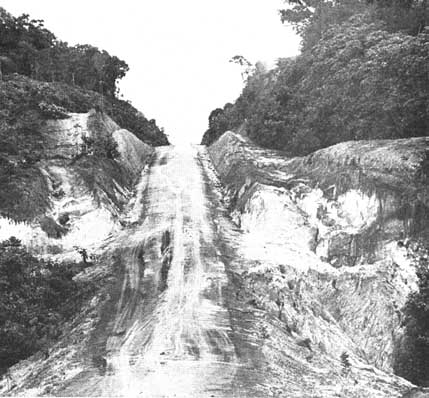
A FOREST ROAD IN BRAZILIAN AMAZONIA shifting cultivation follows the logging roads
Only 38 million hectares, or just over 4 percent, of all productive closed broadleaved tropical forests are at present under regular sustained management plans, of which 29 million hectares, or about 80 percent, are in India. Another 18 percent has been used for timber harvest without any accompanying management plan, and 78 percent is still in a natural state. Here, regional differences are particularly pronounced. Whereas in Asia 49 percent of productive broadleaved forests has been exploited at least once, the comparable figure is only 27 percent in Africa and 10 percent in tropical America. While closed tree formations are to be found mainly in humid and semi-humid regions, open tree formations are typical of drier areas. They cover 734 million hectares compared to 1 200 million hectares of closed forests. Open forests occur mainly in Africa, which has 486 million hectares or 66 percent of all open forest area followed by tropical America with 217 million hectares (30 percent) and Asia with 31 million hectares (4 percent).
|
The 76 countries covered by the Tropical Forest Resources Assessment project Tropical America (23 countries): Belize, Bolivia Brazil, Colombia, Costa Rica, Cuba, Dominican Republic, Ecuador, El Salvador, French Guyana, Guatemala, Guyana, Haiti Jamaica, Honduras, Mexico, Nicaragua, Panama, Paraguay, Peru, Suriname, Trinidad and Tobago, Venezuela. Tropical Africa (37 countries): Angola, Benin, Botswana, Burundi, United Republic of Cameroon, Central African Republic, Chad, Congo, Equatorial Guinea, Ethiopia, Gabon, the Gambia, Ghana, Guinea, Guinea-Bissau, Ivory Coast Kenya, Liberia, Madagascar, Malawi, Mali, Mozambique, Namibia, Nigeria, Rwanda, Senegal, Sierra Leone, Somalia, Sudan, Tanzania, Togo, Uganda, Upper Volta, Zaire, Zambia, Zimbabwe. Tropical Asia (16 countries) Bangladesh, Bhutan, Burma, Brunei, India, Indonesia, Democratic Kampuchea, Lao, Malaysia, Nepal, Pakistan, Papua New Guinea, the Philippines, Sri Lanka, Thailand, Viet Nam. |
So-called "shrub formations" take the place of open tree formations where there are more severe climatic conditions or where there is even greater pressure from grazing than that normally found among open tree formations. They cover 624 million hectares, only 15 percent less area than that occupied by open tree formations. Here again, Africa, with 443 million hectares, or 71 percent of the total area, heads the list, followed by tropical America with 146 million hectares (23 percent) and Asia with 35 million hectares (6 percent).
Fallows can be found within either closed or open tree formations. They cover at present about 410 million hectares, of which 239 million hectares replaced formerly closed formations and 170 million hectares replaced previously open formations. Only 73 million hectares, or 17 percent of the total, are in Asia, while 170 million hectares (42 percent) are in tropical America and 166 million hectares (41 percent) are in Africa. Compared with total forest area, the portion in fallow is very large: it amounts to 20 percent of the land now having closed tree formations, and 23 percent of the land that is now occupied by open formations. In many areas, fallows are increasing rapidly at the expense of undisturbed forest.
Considering the rate of tropical forest depletion during the past five years and the scope of various national development plans, it is estimated that about 7.5 million hectares of closed forests and 3.8 million hectares of open forests will disappear annually between 1981 and 1985, an annual reduction equivalent to 0.62 percent of closed and 0.52 percent of open forests, which comes to an overall rate of 0.6 percent deforested per year. It is striking that the rate of reduction is approximately the same in all three regions. However, the threat to coniferous forests is greater than that to broadleaved forests: in tropical America, 1.25 percent of surviving coniferous forests disappears every year. Along with the above must be considered industrial timber uses in the tropics. These are not intended to destroy forests but they can, in fact, significantly disturb and affect them.
Every year 4.4 million hectares of undisturbed closed forest are subjected to timber exploitation, mostly consisting of broadleaved forests. The logging intensity differs significantly. It is 8 m³ per hectare in tropical America, 13 m³ per hectare in tropical Africa, and 31 m³ per hectare in tropical Asia. Undisturbed Dipterocarp forests in Asia are being logged at a rate of 40-100 m³ per hectare, the commercial value of these species being substantial.
Therefore, to the 11.3 million hectares of tropical forest lost annually through deforestation caused essentially by population growth and subsistence agriculture a further 4.4 million hectares of closed forest affected by new logging activities must be added for a total of 15.7 million hectares annually. Since forests are being cleared principally by agriculture at a rate of 0.6 percent per annum and logging affects an additional 0.2 percent per year, the total annual rate of tropical forest reduction and disturbance is 0.8 percent. Although this is smaller than other estimates, it is still a heavy loss. Furthermore, as has already been mentioned, new logging roads open up hitherto undisturbed closed forests to even more unplanned, uncontrolled subsistence farming. The causes of forest destruction vary among regions and in the countries within those regions. Only a small part of forest loss is due to planned projects.
In Africa shifting cultivation accounts for about 70 percent of the destruction of forests. It is encountered at its worst in the nine countries of West Africa. More than half of all of Africa's deforestation is taking place there. In some places, agriculture is no longer practicable. Four percent of the total closed forest area and as much as 6 percent of the total productive closed forest area in Africa are disappearing annually in West Africa alone.
Conditions in central Africa are quite different. The 350 000 hectares of closed forest disappearing annually in the Congo-Cameroon block make up only 0.2 percent of the total area. In East Africa and Madagascar, however, annual forest destruction amounts to 1 percent of the total closed forest area and 1.65 percent of the productive area.
In Asia, the main areas of forest destruction are located in insular and continental Southeast Asia, where it reaches 1 and 1.1 percent respectively of the total productive closed forest area per year. Here, too, the principal cause is shifting cultivation, which often follows on the heels of industrial timber exploitation. The forest area is relatively stable in India, in Pakistan, in large parts of Burma and Cambodia, and in Papua New Guinea. Government-planned deforestation plays a greater role in Asia than it does in the other two regions. This is particularly true of Peninsular Malaysia, Sumatra and Kalimantan (in Indonesia), and Sri Lanka, where large-scale settlement projects are planned in the years to come.
Only a small part of annual forest losses in the tropics is offset by new plantations. In the reports of the project, new plantations are defined either as afforestation of previously unforested land, or reforestation of previously forested land with new and essentially different crops. For the period 1981-85, annual plantation in tropical countries is put at only about 1.1 million hectares, which includes 29 percent conifers, 55 percent quick-growing broadleaved trees and 16 percent other broadleaved species.
The great merit of the FAO/UNEP study is undoubtedly that it provides sober data and analysis instead of tendentious reports and estimates. This applies especially to the reduction rates of the world's tropical forests that may be expected in the future. Whether the study's forecasts will come true can only be borne out by reassessment in a few years. This means that the study cannot remain a once-only effort, but that permanent monitoring of tropical forest areas must be institutionalized in some form. The present study shows that rapid and continuous monitoring is particularly important and urgent in certain tropical areas where ecological damage is particularly serious or on the way to becoming so.
Since forest resources are not solely located in the tropics, a further step would be to include other forest areas of the world. This would give a more complete picture of global conditions. For the forests of the temperate and boreal zones, the lines of the present study might be followed. Fewer difficulties are likely to arise here than in tropical countries because a greater volume of material, most of it more accurate as well, is already available.
The 6th session of the FAO Committee on Forestry in May 1982, which was attended by many heads of forest services of the world's most important forest countries gave strong support to the project and to continuous monitoring. In its final report, the Committee specifically recommended that the project be extended to include more arid zones outside the tropics and also that "it take into account other components of forest ecosystems such as wildlife and soils".
|
The Tropical Forest Resources Assessment project reports: how to obtain them The reports of the Tropical Forest Assessment project may be purchased from the FAO sales agents listed on the inside back cover of Unasylva or directly from the FAO Distribution and Sales Section, Via delle Terme di Caracalla, 00100 Rome, Italy. Prices are subject to change. · FAO Forestry Paper No. 30, Tropical Forest Resources. A summary report of the entire project. English, French and Spanish editions. 106 pages. Price: US$4.70. · FAO Technical Report 1, Los recursos forestales de la América tropical. Regional synthesis In Spanish only, individual country briefs In English, French or Spanish depending upon the country. 343 pages. Price: US$14.00. · FAO Technical Report 2, Forest Resources of Tropical Africa, Part I: Regional synthesis, English and French editions, 108 pages, price: US$4.60; Part II: Country briefs, individual briefs in English, French and Spanish, depending upon the country, 586 pages, price: US$23.60. · FAO Technical Report 3, Forest Resources of Tropical Asia, in English except for country briefs of Indochina which are in French. 475 pages. Price: US$19.40 |
This article naturally cannot cover all the issues and conclusions contained in the four volumes which form the report on this project and which constitute an important source of information for those who deal with forest resources or with issues of worldwide ecology and the conservation of nature. The project report shows that rain forests are not the only part of tropical forests which are being threatened - and perhaps the threats to them are not even the most serious ones found among the various tropical ecosystems. The disappearance of 4 million hectares of open forest each year, together with an almost imperceptible degradation of the remaining forests as a result of continuous over-exploitation, especially through excessive fuelwood extraction and over-grazing, are still greater dangers. Finally, there is the consistent damage done by fire to large areas of forest. Fires are an especially critical problem in open country where population density is relatively high.
The reports of the Tropical Forest Resources Assessment project constitute an extremely valuable piece of work and contain a wealth of important information. The bibliographic data added to each country report are particularly valuable for the reader who would like to study in depth the problems of individual countries. Unfortunately, of the four volumes only the summary report, entitled with deceptive simplicity Tropical forest resources, FAO Forestry Paper 30, is published in English, French and Spanish. It is hoped that the other volumes will also be made available in these three languages. Not all figures are reliable to the same degree, and some data may contain flaws. The authors themselves point this out repeatedly, indicating the limitations arising from the way in which some of the information was obtained.
The obvious significance of the FAO/UNEP Tropical Forest Resources Assessment project is that it provides the missing base line from which continuous monitoring can now proceed. If it is followed up by such monitoring, it will become of historic importance, not only in the development of forestry as an applied science but in the exercise of environmental responsibility on the part of governments. Continuous monitoring of the world's tropical forest ecosystems would represent an important step toward natural resource husbandry instead of waste. And that would really be significant.
THE FAO FORESTRY MEDAL
Forestry for Development is the message of this striking FAO forestry medal. In gold, silver or bronze, it is an ideal personal memento. As a gift it will be valued and appreciated. One side shows the importance to man of wood for fuel and shelter. The renewability of forests through rational management is depicted on the other side with a new tree growing from the stump of an old one. The medal underlines the urgent need to increase fuelwood production as recommended in the FAO study AGRICULTURE: TOWARD 2000. The Forestry Medal is part of the FAO Coins and Medal Programme's concentration on forestry themes in 1984, the year of the 9th World Forestry Congress to the held in Mexico. Readers of UNASYLVA receive a 10 % discount. Use the order form.
Send this coupon to: Medals Programme (B-111) - FAO - 00100 Rome
|
FAO Forestry Medal |
Quantity |
Full price US $ |
Discount price US$ |
|
gold (18 carat) 28 mm (9/10 in.) |
|
280 |
252 |
|
sterling silver (925) 50 mm (2 in.) |
|
65 |
59 |
|
bronze 50 mm (2 in.) |
|
20 |
18 |
|
name | |||
|
address | |||
|
signature | |||
|
date | |||
![]()
![]()